Near-surface wildfire smoke forecast for 4 a.m. PDT August 3, 2020. NOAA HRRR-Smoke.
Smoke from southern California’s 20,000-acre Apple Fire is predicted to move north overnight Sunday. Monday morning it is expected to affect areas in areas of Arizona, Nevada, Utah, Wyoming, and Idaho.
The map above created by NOAA is for near-surface smoke which can affect humans more than vertically integrated smoke higher in the atmosphere.
NOAA predicts that a new fire in north-central Oregon, the Fir Mountain Road Fire seven miles south-southeast of Hood River, will produce smoke that will move into eastern Oregon, southeast Washington, and eastern Idaho. The fire started Saturday night, and Sunday morning was estimated at 70 acres. It seems surprising that it could be generating such a large quantity of smoke, however it is burning in slash piles from recent logging, as well as adjacent standing timber.
Fir Mountain Road Fire. Oregon Department of Forestry photo August 2, 2020.
Two air tankers collided July 30 while working on the Bishop Fire in southeast Nevada.
The Air Tractor Single Engine Air Tankers, SEATs, were involved in a mid-air collision Thursday afternoon according to Federal Aviation Administration spokeswoman Claire Morville. There was one person on board each aircraft.
At 10 p.m. MDT July 30 a spokesperson for the Bureau of Land Management, Chris Hanefeld, confirmed that the collision occurred earlier in the day at about 12:55 p.m. He said both pilots were killed in the crash. Recovery operations are currently underway and initial notifications are still being made.
“We offer our sincere condolences to the families of the two pilots and to all those working with the BLM Nevada Ely District,” said BLM Nevada State Director Jon Raby.
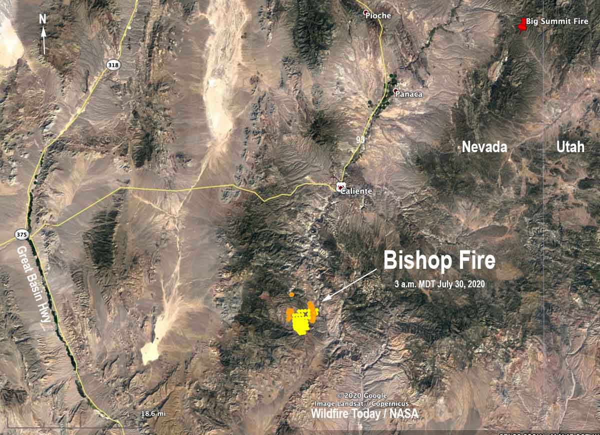
Map showing heat detected by satellites on the Bishop fire as late as 3 a.m. MDT July 30, 2020.
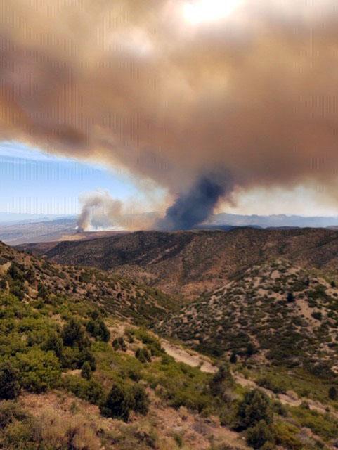
The Bishop fire, reported July 29, has burned 500 acres 14 miles south-southwest of Caliente, Nevada.
The accident occurred near the intersection of Kane Springs Road and Riggs Road, Ms. Morville said.
The fire is on land managed by the BLM. The two privately owned aircraft were under contract to the agency.
SEATs are small airplanes used to support wildland firefighters on the ground. They can deliver up to 800 gallons of fire retardant and operate in areas where larger airtankers cannot.
The names of the pilots have not been released.
Our sincere condolences go out to the pilots’ family, friends, and coworkers.
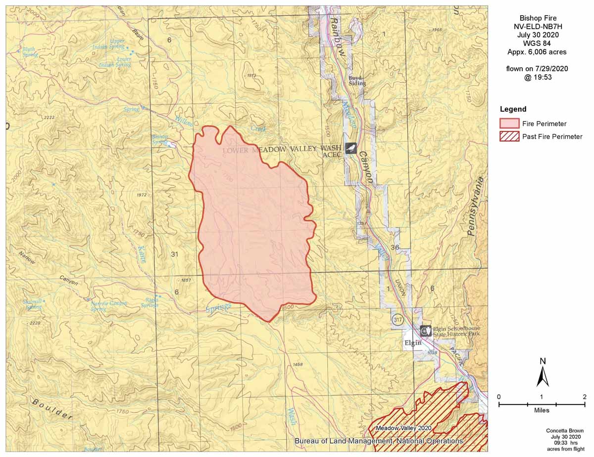
Bishop Fire map. Data from 7:53 p.m. MDT July 29, 2020. BLM.
Thanks and a tip of the hat go out to Tom. Typos or errors, report them HERE.
Most of the smoke was generated by the Caldwell Fire in northeast California
Wildfire smoke forecast for 6 a.m. MDT July 25, 2020. NOAA.
The map shows the forecast for the distribution of vertically integrated smoke from wildfires at 6 a.m. MDT July 26, 2020. Most of the smoke is from the Caldwell Fire in northeast California.
Preliminary evidence suggests exposure to wildfire smoke may increase susceptibility to COVID-19
The U.S. Forest Service has published a three-page fact sheet with information about the impacts of wildfire smoke during the COVID-19 pandemic. It covers the effects of smoke during the pandemic, who is most at risk, symptoms, masks and face coverings, and how to minimize potential health effects from wildfire smoke. The document has useful information and many links to additional materials.
Here are some excerpts:
The COVID-19 pandemic is overlapping with the occurrence of wildfires in the United States.
Wildfire smoke is a complex mixture of air pollutants that are harmful to human health.
Exposure to air pollutants in wildfire smoke can irritate the lungs, cause inflammation, alter immune function, and increase susceptibility to respiratory infections, likely including COVID-19.
Those with or recovering from COVID-19 may be at increased risk of health effects from exposure to wildfire smoke due to compromised heart and lung function caused by the disease.
Although N95 respirators provide protection from wildfire smoke, they might be in short supply as frontline healthcare workers use them during the pandemic.
Cloth face coverings that are used to slow the spread of COVID-19 offer little protection against harmful air pollutants in wildfire smoke because these coverings do not capture most small particles in smoke.
Satellite photo of smoke from fires in New South Wales and Victoria January 4, 2020. The red areas represent heat.
In northern Montana Thursday morning seven fires were discovered in Glacier National Park in the North Fork area. Park spokesperson Gina Kerzman said they have all been controlled but the Ford Creek Patrol Cabin built in 1928 which is on the National Register of Historic Places was destroyed.
Due to the suspicious nature of the fires, several investigators are on scene including the FBI and the National Park Service’s Investigative Services Branch, which is assisting remotely.
Anyone with information about the fires is urged to call 406-888-7077.
Resources responding to the fires included local county, state, and federal agencies with hotshot crews, engine crews, and law enforcement personnel.
The Ford Creek Patrol Cabin was built in 1928. The rustic log structure was a significant resource both architecturally and historically as part of a network of shelters approximately one day’s travel apart used by patrolling backcountry rangers.
The nomination of the Ford Creek Patrol Cabin to be on the National Register of Historic Places prepared in 1984 included this description:
“In 1928, Glacier National Park appropriated $2,000 for the construction of four identical snowshoe cabins. The Park hired private contractors to erect the buildings since the staff carpenter force was occupied with construction at Belton headquarters. Documents do not indicate the names of the contractors, although invitations to bid were sent to “several good log men in the vicinity.” The Park provided floor shiplap, roofing materials, cement, okem (chinking), cellar planks, windows and doors and their frames, shakes, and hardware. The contractor cleared the site, cut trees marked by the Park Engineer, built the cabin, and cleared the site.
“The project took three weeks and the cost for all materials and labor totaled $350. This cabin is one of many similar structures built in Glacier National Park during the 1920s and 1930s to facilitate the supervision of lands within the park boundaries. The park’s rugged topography and the often rapidly changing weather conditions made it imperative that these cabins be built at strategic points to protect rangers charged with park surveillance. The cabins were usually located 8 to 12 miles from a permanent ranger station. Thus, a park ranger could spend a number of days on patrol duty without returning to the station for supplies or shelter. The Ford Creek patrol cabin is significant because it illustrates an important aspect in the development and administration of Glacier National Park.
“It is a one-story, rectangular log structure with new corrugated metal on a gable roof, a metal stove pipe, and nine log purlins. The wall logs are saddle notched with sapling chinking and square-cut crowns. There is a concrete alignment foundation under the structure and porch posts. The roof extends to a full porch with a tie beam and vertical pole beneath the ends of seven purlins. There are shakes in the gable ends. The door is solid wood and “bear-proofed.” The windows are iron bars woven with barbed wire over six-light, wood frame casements. The structure is in good condition.”
Thanks and a tip of the hat go out to Kelly. Typos or errors, report them HERE.
Originally published at 3:18 p.m. PDT July 23, 2020
Lightning during the 48-hour period ending at 2:29 p.m. PDT July 23, 2020. The red areas are the most recent.
During the last 48 hours thunderstorms with lightning moved across several states in the northwest leading to the possibility of new wildfire ignitions. Most heavily affected were northern and northeast California, southeast Oregon, the south half of Idaho, and western Montana. Precipitation accompanying the cells was spotty.
Precipitation during the 48-hour period ending at 2 p.m. PDT July 23, 2020. NWS.