Wildfire potential, May through August, 2017

Posted on Categories UncategorizedTags ,

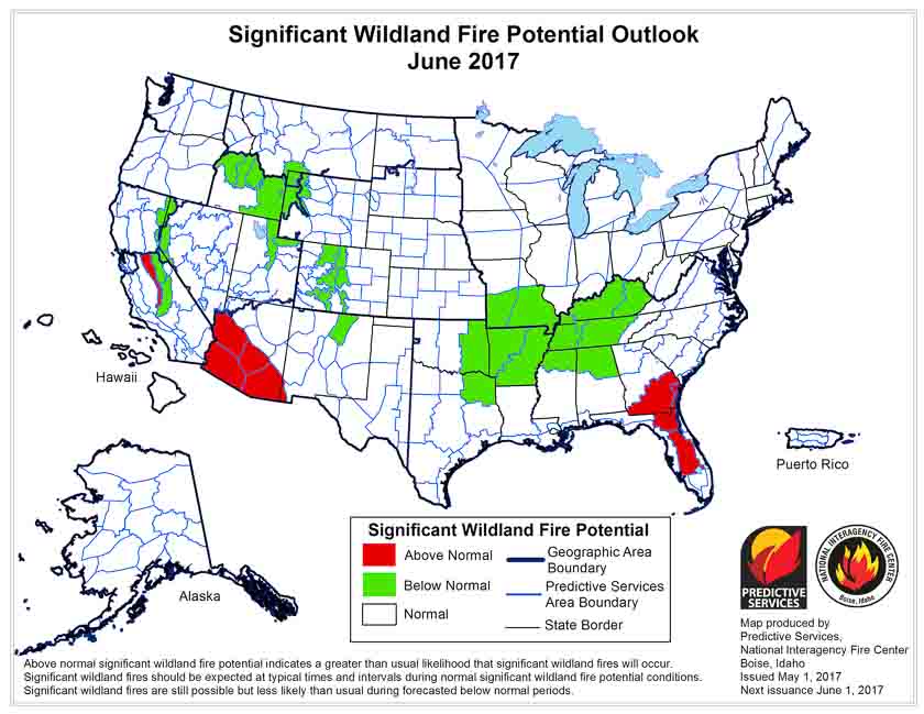
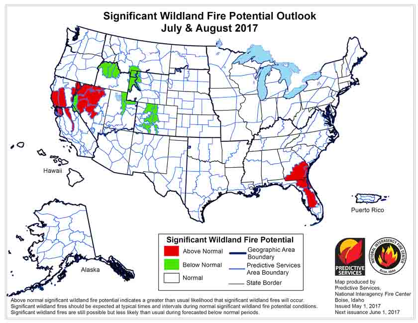
On May 1 the Predictive Services section at the National Interagency Fire Center issued their Wildland Fire Potential Outlook for May through August. The data represents the cumulative forecasts of the ten Geographic Area Predictive Services Units and the National Predictive Services Unit.

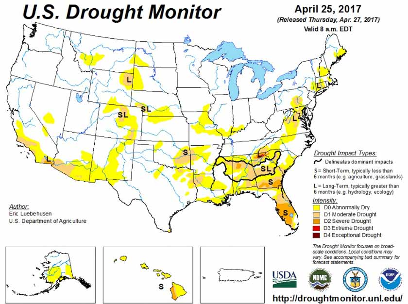
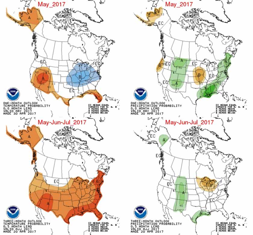
Below are the highlights of their report, NIFC’s graphical outlooks for May through August, the Drought Monitor, and NOAA’s temperature and precipitation forecasts.

Florida and southeastern Georgia continue to experience significant fire activity as warmer and drier than normal conditions persist. Worsening drought conditions in these areas continue to lead to increased fire activity and behavior. Recent precipitation events have not been significant or frequent enough to provide relief. The existing conditions and activity are expected to peak by early June before beginning to show improvement and subside as tropical patterns develop bringing beneficial precipitation.

Wildfire activity across the Southern Plains has begun to wane as the seasonal shift westward begins. Greenup has begun to take hold and precipitation events have become more common across the Central and Northern Plains.

Arizona and western New Mexico will see an increase in fire activity in May and June as the region enters the heart of its fire season. Heavy growth of fine fuels across southern Arizona and southwestern New Mexico have led to above normal fire potential along the Mexican border that should persist through June before the monsoonal rains arrive in early July and decrease activity.

As the fire season progresses into July, there are concerns with the seasonal shift west and north into California, and Great Basin. Exceptional winter and early spring precipitation is leading to the development of a substantial crop of fine fuels in the lower and middle elevations. The heavy loading of fine fuels could become problematic when they cure out in July. In the higher elevations, the mountain snowpack continues to melt at a normal to slower than normal rate. This should produce a delay in the onset of significant fire activity in the high elevations.

In Alaska, the south central portion of the state continues to be abnormally dry. While overall normal fire potential is forecast, bursts of more significant fire activity are possible across the interior portion of the state.

By mid-late July, the western fire season will begin to progress north into the Pacific Northwest and Northern Rockies. While a normal transition into fire season is expected in the lower elevations, a delayed entrance is possible in the higher elevations as both regions enter their fire seasons having seen abundant winter and spring precipitation and snowpack accumulation.

wildfire potential june 2017 wildfire potential july august 2017 Precipitation Temperature outlook map

What does Logistics do on a wildfire in Florida?

Above: Logistics Section Chief Cindy Schiffer with the Southern Area Blue Team. From the video.

We appreciate it when local units put together short videos, especially at a fire, showing the public what they are doing. This particular one, filmed at the 21,000-acre Cowbell Fire at Big Cypress National Preserve in south Florida, features Logistics Section Chief Cindy Schiffer explaining how her section provides the support firefighters need to continue battling the fire. It’s very well done.

New satellite aided firefighters during fire siege in Kansas and Oklahoma

Posted on Categories UncategorizedTags

Above: The image from the new GOES-16 satellite is from March 6, 2017 just as the wind was shifting 90 degrees from the southwest to the northwest near the Kansas/Oklahoma border.

This article is for the weather and remote sensing geeks out there and anyone who is interested in the latest developments about the real time detection of wildfires from space.

During the siege of wildfires on March 6 and 7 in Kansas, Oklahoma, and northern Texas strong winds before and after a frontal passage fanned existing small fires into huge firestorms that burned about a million acres in Kansas alone. Six people were killed and firefighters were stretched far beyond the capabilities of the mostly rural departments they served.

While this was going on a few meteorologists with access to the new, still being tested GOES-16 satellite were monitoring the emerging wildfire situation. This game-changing satellite orbiting hundreds of miles overhead has a baseline imager that will view the Earth with 16 different spectral bands (compared to five on current GOES satellites) and it will provide three times more spectral information, four times the spatial resolution, and more than five times faster temporal coverage than the current system. It also has the first satellite sensor dedicated to detecting real time lightning.

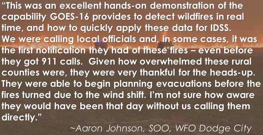
This video explains how data from GOES-16 was used as the fires were burning, including notifying fire departments of what the fires were doing, where they were, and what they were likely to do as the front passed, shifting the wind and the direction of fire spread 90 degrees from the southwest to the northwest.

If you don’t have time to view the entire 12-minute presentation, at least check out the change in direction of spread of the fires that begins at 8:30.

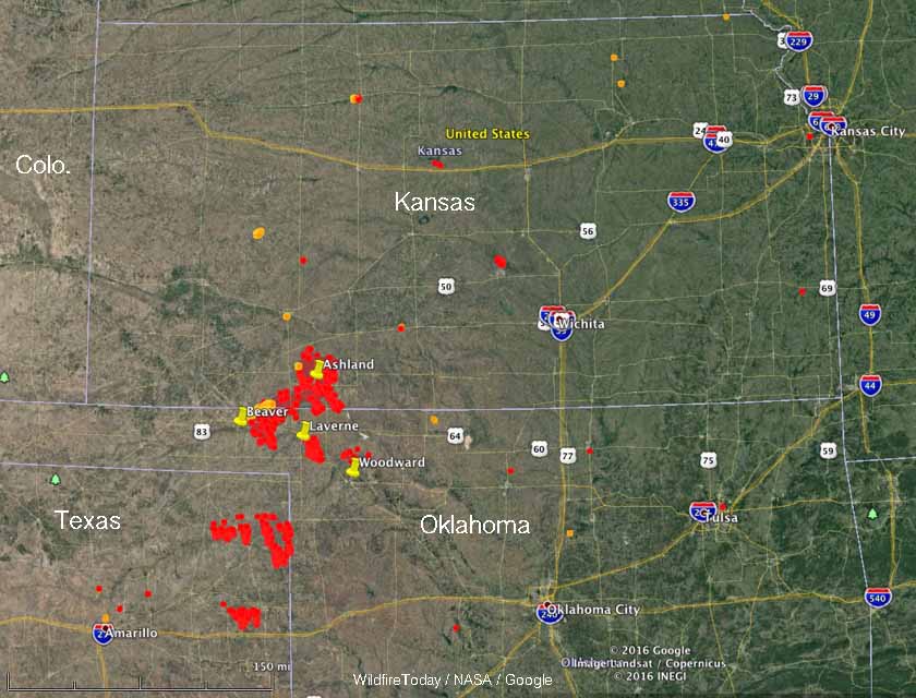
fires map kansas oklahoma texas
The red and yellow dots represent heat detected by a satellite in the 24 hours before 11:30 a.m. CST March 7, 2017. Map by Wildfire Today.

The images below are screenshots from the video.

GOES16 wildfire detectionGOES16 wildfire detection

Off duty Border Patrol agent connected to origin of 46,000-acre Sawmill Fire

There are reports that the fire was ignited by an exploding target

(Updated at 1:15 p.m. MDT April 28, 2017)

The U.S. Border Patrol has confirmed that one of their off duty agents is being investigated in the cause of the Sawmill Fire that has burned over 46,000 acres 23 miles southeast of Tucson, Arizona. In an email to several media outlets the public affairs office of the agency wrote:

We are aware that the Sawmill Fire investigation involves an off-duty Tucson Sector Border Patrol agent. The agent was involved in recreational shooting and immediately reported the fire after it begun. All questions regarding the investigation should be directed to the state fire agency.


Sawmill Fire
Firefighters conduct burnout operations On the Sawmill Fire along Empire Ranch Road on April 26, 2017. Inciweb photo.

The Green Valley News reported earlier that multiple sources they spoke with said a recreational shooter using exploding targets started what became the Sawmill Fire. Those reports also said the shooter tried to put it out, but when that failed, he notified authorities.

Exploding targets are known to have started numerous fires and are banned many areas.

On Thursday resources assigned to the Sawmill Fire included 799 personnel, 16 hand crews, 67 engines, and 5 helicopters. The suppression cost to date was $3 million.

Articles on Wildfire Today tagged exploding targets.

Report released on fatal BLM engine rollover

BLM Unimog Engine 2410 when it was new in 2006. BLM photo.

The Bureau of Land Management has released an Accident Investigation Factual Report for the July 10, 2016 engine rollover north of Winnemucca, Nevada in which two firefighters were killed and a third was seriously injured.

Jacob O’Malley and Will Hawkins lost their lives in the single-vehicle accident on Nevada State Route 140 when a rear tire suddenly and catastrophically failed. The truck only had four tires, there were no duals on the rear. When the right-rear rim dragged along the pavement the left-front was in the air, eliminating any possibility of control by the driver. The 33,000 pound GVWR engine fishtailed and then rolled several times.

The cab was higher than the water tanks and pump package, so it took the majority of the impact as the top of the vehicle struck the roadway during the rollover. All three occupants were wearing seat belts but with the top of the cab and the A pillar being damaged or sheared off, the restraint system failed to operate as designed. Mr. Hawkins was ejected from the cab and then was hit by the rolling wreckage.

Below is an excerpt from the report:

Finding 3.1 (Material): During the rollover, the upper cab structure (made of reinforced carbon fiber) sheared away from the truck frame, exposing the vehicle’s occupants to a hazardous environment. The disintegration of the cab compromised the driver’s and right side passenger’s seatbelt systems.

Discussion 3.1: The lack of cab crashworthiness did not cause the rollover; however, it contributed to the fatal conditions which occurred during the crash. The reinforced carbon fiber cab on the Unimog was manufactured in France and was built to United Nations Code ECE r29 (commercial vehicle occupant protection), which exceeds U.S. cab crashworthiness standards. The U.S. National Highway Traffic Safety Administration (NHTSA) submitted a report to Congress in 2015 on the need for improved heavy truck crashworthiness standards; however, no action has been taken on this report as of February 2017.

There are 41 articles on Wildfire Today about the rollovers of wildland fire apparatus.

We still stand behind what we wrote in a 2015 article about the many firefighter fatalities from rollovers:

The wildland fire agencies should fund research conducted by engineers to determine how to prevent the passenger compartments in their fire engines from collapsing in accidents.

Thanks and a tip of the hat go out to Eric.
Typos or errors, report them HERE.

Firefighters make progress on the Sawmill Fire in Arizona

Above: Map of the Sawmill Fire east of Green Valley, Arizona as of April 26, 2017. 

Firefighters battling the 46,954-acre Sawmill Fire 23 miles southeast of Tucson have been able to slow the spread over the last two days in spite of strong winds. Satellite imagery from early Friday morning did not show any large concentrations of heat over the previous 24 hours. This does not mean the fire is out, and there is no doubt a lot of line building and mopup work still has to be accomplished.

For the last two days the Sawmill Fire has been most active on the northeast side where aircraft have been assisting firefighters on the ground to slow the spread.

A Red Flag Warning for strong winds is still in place for the fire area as well as most of southern Arizona and southwest New Mexico.

On Thursday the Arizona Department of Transportation reopened Arizona Highway 83 south of Interstate 10.

The Pima County Office of Emergency Management has lifted the pre-evacuation order for residents on the west side of Arizona Highway 83. Residents in the Hilton Ranch area remain under pre-evacuation notice. An evacuation order remains in place for Rain Valley.