Above: Clouds in the satellite photo obscure some of the smoke produced by wildfires in SC, GA, NC, and TN.

For the latest articles at Wildfire Today about wildfire smoke check out the articles tagged “smoke”.
News and opinion about wildland fire
Above: Clouds in the satellite photo obscure some of the smoke produced by wildfires in SC, GA, NC, and TN.

For the latest articles at Wildfire Today about wildfire smoke check out the articles tagged “smoke”.
This is the forecast for the distribution of wildfire smoke for 6 p.m. ET, Sunday, November 13, 2016. Courtesy of NOAA. It was produced at 1 p.m. ET, November 12, 2016.
For a satellite photo of actual wildfire smoke on Friday, click HERE.
For the latest articles at Wildfire Today about wildfire smoke check out the articles tagged “smoke”.
Above: Smoke from wildfires drifts into Tennessee, North Carolina, and northern Georgia, November 12, 2016. NASA, with notations by Wildfire Today.
As the siege of wildfires continues in the southeast United States the smoke from the blazes continues to impact residents in the area. As the wind direction changes from day to day different populations are affected. Most of the smoke Saturday was blowing to the west and southwest.
We did some quick mapping and found that on Saturday approximately 4.5 million residents were experiencing moderate to heavy smoke in northern Georgia, northern Alabama, eastern Tennessee, and western North Carolina. Almost the entire state of Alabama was affected by lesser concentrations.

Continue reading “Tennessee and North Carolina receiving the worst of the smoke on Saturday”
These photos are from the very impressive Rough Ridge Fire in north Georgia 13 miles west of Blue Ridge. They were uploaded to InciWeb Friday.
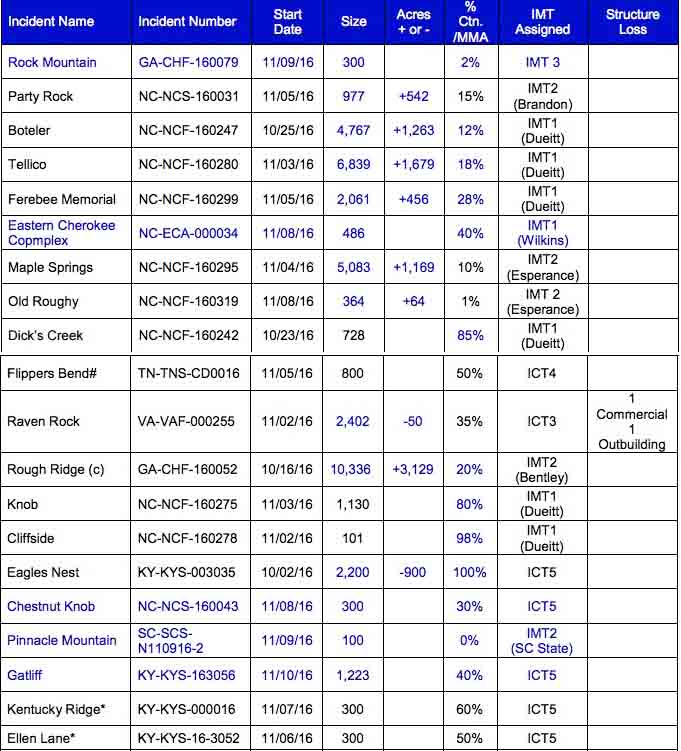
The fire has burned 10,336 acres and currently threatens 48 structures. Approximately 227 personnel are assigned.

Above: The map shows the location of some of the larger wildfires in North Carolina, South Carolina, and Georgia November 11, 2016.
(UPDATED at 4:59 p.m. ET November 11, 2016)
The intense wildfire activity that has been going on for weeks in the southeast United States ramped up a bit over the last 24 hours as extremely low relative humidities allowed some of the blazes to continue to spread aggressively Thursday night. A weather station southeast of Asheville, NC 9 miles northwest of the 977-acre Party Rock Fire recorded 9 percent RH early Friday morning. Night time humidities in that part of the country are usually far above 50 percent at night.
The good news is the conditions will moderate a little over the next several days after the passage of a cold front.

There are currently 31 uncontained wildfires in the Southern Geographic Area. Here some other numbers about the fires in the region (data from the National Interagency Coordination Center and the Southern Area Coordination Center):

Continue reading “Heavy wildfire activity continues in North Carolina and Georgia”
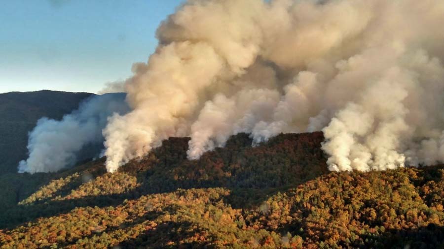
Above: Party Rock Fire near Chimney Rock, NC. Photo by Cathy Anderson.
(UPDATED at 11:53 a.m. ET November 12, 2016)
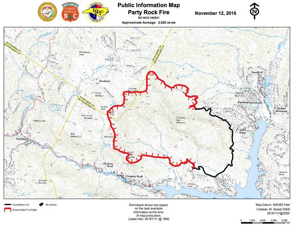
The Party Rock Fire at Chimney Rock, North Carolina continued to spread on Friday and has now blackened 2,626 acres according to information from the Incident Management Team at 7 p.m. on Friday.
Areas under mandatory evacuation orders include the entire community of Chimney Rock, the Highway 74-A corridor west of Chimney Rock, Rumbling Bald Resort, and some areas in the Town of Lake Lure.
There are no reports of any structures being destroyed.

On Friday air tankers and helicopters dropped water and retardant to help slow the spread of the fire and to protect the communities.
A section of Highway 74-A was closed for a period of time Friday afternoon.

The weather has changed to be more in favor of the firefighters. After some single-digit relative humidities earlier in the week, on Saturday it should bottom out at 30 percent in the fire area after having risen to around 80 percent overnight. The wind will not be a major problem, and is predicted to be out of the northeast at 4 to 6 mph with gusts of 5 to 10 mph. The high temperature will be 53 degrees. Sunday will be about the same, but a little warmer and drier.
****
(Originally published at 2:01 ET November 11, 2016)
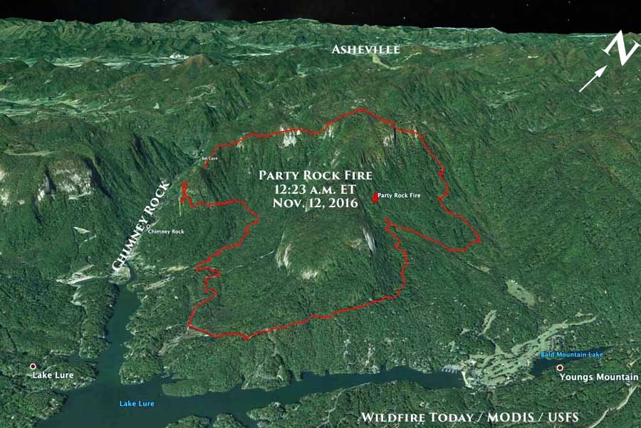
The rapid spread of the Party Rock Fire overnight is causing evacuations for some areas within the community of Chimney Rock, North Carolina. The fire is just west of Lake Lure, on the north side of Chimney Rock, and is 18 miles southeast of Asheville.
Here is a link to a map with details about the evacuation.
The fire started November 5 in Chimney Rock State Park and is being managed by Dan Brandon’s North Carolina Type 2 Incident Management Team. As of Thursday evening it had burned 977 acres and was being fought by 165 personnel.
Part of the reason for the increased fire activity over the last 24 hours was the extremely low relative humidity. It is not uncommon for this part of the country to have the RH go up near 100 percent at night, but Thursday afternoon it got down to 10 percent, went up to around 30 percent at midnight, then dropped as low as 9 percent before sunrise. At 2:04 p.m. ET on Friday it was 27 percent, still low for North Carolina. Aggravating the situation was 10 to 20 mph wind gusts out of the west and southeast.
The forecast calls for the RH to rise into the 40s later Friday afternoon and into the 70s during the night. The wind Friday afternoon will be out of the north and northwest at 8 mph with 20 mph gusts. The temperature will be around 60. These conditions will be challenging for firefighters
Saturday the RH will be in the 40s under sunny skies.