Red Flag Warnings, October 13, 2016

The National Weather Service has posted Red Flag Warnings or Fire Weather Watches for areas in California, Nevada, Arizona, Wyoming, Nebraska, South Dakota, and Colorado. For most of the locations the conditions will persist into Friday.

The Red Flag map was current as of 9:50 a.m. MDT on Thursday. Red Flag Warnings can change throughout the day as the National Weather Service offices around the country update and revise their forecasts and maps.

wildfire red flag warnings
Red Flag Warnings (red) and Fire Weather Watches (yellow) for October 13, 2016.

Smokejumpers on a 1-acre fire get chased by another fire

“We do not have a safety zone, and our escape route is threatened.”

Above: File photo. Smokejumpers at Missoula board a Twin Otter, August 11, 2012. Photo by Bill Gabbert.

I didn’t know the Bleacher Report covered anything other than sports, but earlier this week they published a lengthy article about smokejumpers unfortunately titled, “Superheroes Are Real”. It is mostly well written by Rachel Monroe and explores rookie training, firefighting, and aspects of waiting at an airport for a fire dispatch.

Much of the story is told from the viewpoint of Erik Vermaas, who had at least one memorable quote:

[Hotshots] walk in single file in fire camp,” says Vermaas, the second-year jumper. “You can just tell smokejumpers are different. They’re not a number. These dudes roll through fire camp and it’s like, Who the f*** is that? You can tell.

Part of the article describes how “last summer” three of them jumped on a fire in the Selway-Bitterroot Wilderness, near the Idaho-Washington-Oregon border and by the fourth day had the one-acre blaze pretty much wrapped up.  The excerpt below picks up on that fourth day:

****

“…At nine that morning, a pilot flying overhead radioed the crew: You guys know you’ve got a fire-start right next to you? One of the other jumpers volunteered to bushwhack up the ridge to check out what was going on. It was slow going; the jumpers had been working in the thick, 20-foot-high brush that made walking a quarter-mile feel more like walking four. When the scout made it to the top of the ridge, he immediately radioed back: Let’s get out of here.

The fire had crowned—that is, started burning in the tops of the trees. The wind was pushing it toward the jumpers, and it was moving fast. In other circumstances, maybe the jumpers would have radioed for a plane to dump a tanker of retardant on the flames to slow things down, but by around 11 a.m., all those little fires had merged into a big one, and the smoke was so thick the helicopters couldn’t see a damn thing. Vermaas and the other jumper waited anxiously for the scout to fight through the brush back to them. The other jumper with Vermaas, a guy with decades of experience, barked into the radio: We do not have a safety zone, and our escape route is threatened. “That means,” Vermaas explains, “you basically are running out of options.”

Vermaas heard the loud, gunning sound of what he thought was a helicopter; he watched the treetops sway and felt a momentary surge of relief—until he realized that it wasn’t a chopper making that sound, or all that whooshing wind. The danger was the fire itself, ripping its way through the treetops toward them. No plane or rescue vehicle could make it anywhere near them; they’d have to get themselves out of this mess, and fast.

By the time the third crew member showed up, Vermaas says, “it was already f****** go time.” The jumpers ditched their gear—“We made the decision, ‘F*** the gear, f*** everything, leave it, we’re going’”—and made their way through the brush, racing the fire down toward the river. Vermaas tried not to think about what would happen if the fire spotted and caught below them—fire burns fastest uphill, and when it gets going even the most fleet-footed smokejumper doesn’t stand a chance. All three jumpers made it down to a creek and safe haven, but it was close.

Vermaas stood in the creekbed, then watched as the trees swayed with the energy only a fire could create—when wildfires burn hot enough, they can generate their own weather. Half an hour or so more and those flames would’ve burned right over them. Days later, a salvage crew went in to look for the jumpers’ gear. The only remnants they found were metal grills from their jump helmets and six fasteners from their parachutes. Everything else had been reduced to ashes…”

****
Thanks and a tip of the hat go out to Paul.

Helping a family deal with a line of duty firefighter fatality

This is a wonderful story about how after the 2004 line of duty death of a wildland firefighter, the family was immeasurably helped by the firefighter’s crew, the agency, and the Wildland Firefighter Foundation (who produced this video in 2016). And it continued for more than a decade.

Sequoia NP reintroduces fire where it had been excluded for decades

This week the National Park Service reintroduced fire to an area in Sequoia National Park where it had been unnaturally excluded for decades. The 187-acre Dorst prescribed fire near Dorst Campground is expected to help restore a more natural density of fuels and vegetation.

All photos were provided by the NPS.

Dorst prescribed fire Sequoia National Park
Dorst prescribed fire, October 10, 2016. NPS photo.

Dorst prescribed fire Sequoia National Park

Pile burning on the Beaverhead-Deerlodge NF

Over the last week Derek Wittenberg has been working with his colleagues on the Beaverhead-Deerlodge National Forest in western Montana (map) burning piles that were created while building a fuel break on the Pole Fire. Other piles were part of a project to promote a Whitebark Pine stand that is resistant to Blister Rust.

He posted photos and videos on his Instagram page that are used here with his permission.

Piles like these are often burned while there is snow on the ground in order to minimize the chance of the fires spreading out of control. Some of the keys to success are constructing the piles so that some material remains relatively dry even after rain or snow, and using firefighters that are skilled with a drip torch.

The crew took advantage of the opportunity to conduct training with a Very Pistol.

Veri pistol training and pile burning

A photo posted by Derek Wittenberg (@ridebigmtn) on

#burnpilesinstyle

A video posted by Derek Wittenberg (@ridebigmtn) on


Continue reading “Pile burning on the Beaverhead-Deerlodge NF”

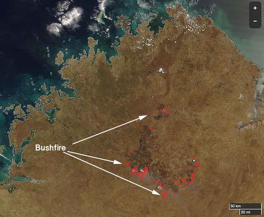
Bushfire in Western Australia burns millions of acres


A huge bushfire in the Kimberley region of Western Australia has burned approximately 2.4 million acres (1 million hectares). Since it started from lightning two weeks ago it has been spreading across cattle stations on both sides of Gibb River Road and recently began approaching Aboriginal communities. Not all fires in sparsely populated areas of Western Australia are aggressively suppressed but firefighters have been working around the clock this week to put in a fireline on the north side near Gibb River Road station.

Kimberly region bushfire map
The Kimberley region of the north part of Western Australia. The red dots represent heat detected by a satellite October 10, 2016. The black areas near the dots are most likely recently burned. Note the graphic scale at bottom-right.  MODIS/Wildfire Today.

Below is an excerpt from an article at ABC.NET in Australia:

Indigenous ranger groups from across the region have converged on the area to help, some travelling hundreds of kilometres. There is concern about the impact the bushfire will have on the landscape, which covers both prime grazing country and biodiversity hotspots.

The fire is now heading towards properties managed by the Australian Wildlife Conservancy. The group’s national operations manager Tim Allard said it would have a harsh impact on native species.

“It’s a significant fire and a significant chunk of land has been burnt in one event,” he said.

“It’s decimated the habitat for so many animals … [and] the other issue is it destroys all of the refuge for native animals to hide from feral cats.”