The National Weather Service has posted Red Flag Warnings and Fire Weather Watches for areas in California, Nevada, Utah, Idaho, Oregon and Montana.
The maps were current as of 7:45 a.m. MDT on Sunday. Red Flag Warnings can change throughout the day as the National Weather Service offices around the country update and revise their forecasts and maps. For the most current data visit this NWS site.
Drones shut down air operations over the Pioneer fire for 45 minutes on Sunday, while the fire continued to spread due to erratic weather conditions.
In a post on InciWeb, the incident management team said the drone incursion came at a critical time for firefighters.
Aviation operations once again stopped for 45 minutes during a critical period of fire suppression due to an unmanned aircraft incursion. IF YOU FLY WE CAN’T. PLEASE DO NOT FLY DRONES IN OR NEAR THE FIRE AREA.
Such a delay seems to have become common place on many fires, and last week incident management teams in California and Montana reported halting air operations due to drones in the area.
A spokeswoman for the National Interagency Fire Center has urged people not to flying drones into wildfire areas, and has said that people caught flying drones in wildfire zones could face criminal charges.
Meanwhile, the Pioneer fire has burned 27,271 acres and is 27 percent contained.
***
Crews on the 18,933-acre Pioneer fire north of Idaho City are facing a weekend of windy weather, which will likely fan the flames of a fire that has been burning since July 18.
Here’s the outlook for Sunday’s weather:
A passing cold front this evening may produce thunderstorms with gusty, erratic winds and increased fire behavior.Smoke will likely again be visible from great distances.
Crews are also grappling with poor access, steep terrain, dry forests and old mining sites, according to posts on InciWeb.
On Friday, heavy smoke from the fire drifted east and triggered warnings for unhealthy levels of smoke pollution. Smoke from the Pioneer fire was also drifting into Northern Colorado.
Smoke from U.S. wildfires, July 29, 2016. Weatherunderground.
Smoke from western wildfires in Idaho and Colorado is expected to worsen over the weekend as it drifts east.
The Pioneer fire burning outside of Boise emitted a pillowing plume of smoke on Friday that could be seen from miles away. As of Friday night, the Idaho Department of Environmental Quality had issued an unhealthy air quality warning for areas around Ketchum, due east of the Pioneer fire.
Colorado residents are also likely to see more smoke in the area this weekend as smoke from the Pioneer fire drifts east and mixes with plumes from Colorado’s Beaver Creek fire.
Firefighters are anticipating that it will take them until late October to contain the Beaver Creek fire, which is burning in one of the forests hardest hit by mountain pine beetle.
Tactics being used to contain the blaze have already emerged as a case study in how to suppress fire in an environment transfigured by thousands of dead trees.
Beetle-kill trees in the area thwarted firefighters’ attempts at a direct attack — downed trees made building a fireline difficult and gusts from helicopter rotors only caused more trees to fall, according to a lessons learned report published on July 27.
An indirect approach containing the fire became essential when initial attack crews felt radiant heat from flames a half a mile away:
Because of the extreme fire behavior exhibited early on in the Beaver Creek Fire, firefighters knew a direct attack would be both dangerous and ineffective…Firefighters removed fuels, wrapped buildings, laid hoses and sprinklers around the structures, and strategically burned out around buildings in advance of the fire.
The conditions in the Routt National Forest, along the Colorado-Wyoming border, also proved challenging to firefighter safety, according to a post from the incident management team on InciWeb.
The fire is burning in heavy beetle killed timber. The infested trees are subject to blowing over contributing large amounts of down timber and providing fuel for extreme fire behavior when strong winds and terrain features are in alignment, making the timbered areas unsafe for firefighters.
The fire, which started on June 19 in north-central Colorado, spread by several hundred acres during a hot, windy and humid day this week and forced firefighters to pull back to safety zones, The Denver Post reported.
As of July 29, the fire had burned 30,137 acres and is 12 percent contained.
Map of the Soberanes Fire at 2:30 a.m. August 2, 2016.
Damage assessment teams have identified 57 residences and 11 outbuildings that have been destroyed in the Soberanes Fire between Big Sur and Monterey, California.
The Incident Commander, Todd Derum, reports that firefighters have achieved 18 percent containment after fighting the blaze for 12 days, which has now blackened over 43,000 acres.
Several areas are still under evacuation orders.
On the west side the fire has come close to reaching the Pacific Ocean, while the east side is 14 to 18 miles west of US Highway 101.
Resources assigned to the fire include: Engines: 510, Water tenders: 51, Helicopters: 17, Air Tankers: 6, Hand Crews: 107, Dozers: 72, Other: 14, Total Personnel: 5,451.
The Soberanes fire in Big Sur continues to rage with little containment, and on Sunday it prompted more evacuations of local residents.
Businesses in the area have already begun to suffer from the shutdown of various state parks in the famously scenic coastal region, according to a story from Market Watch.
As of Monday morning, the fire had burned 40,618 acres and was 18 percent contained, according to InciWeb.
The rugged firefighting conditions mixed with hot weather have made the fire harder to contain:
Extremely remote and rugged terrain with limited access coupled with hot and dry weather and an above average cured grass crop has resulted in a high resistance to control.
— Alameda County Fire (@AlamedaCoFire) July 29, 2016
The Soberanes fire in Monterey County has shifted California’s focus from Los Angeles to Big Sur, where the fire has shut down several state parks, destroyed dozens of homes and continues to burn with little containment.
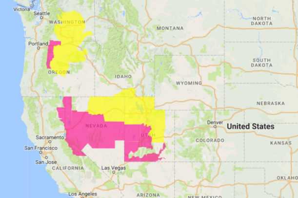
The National Weather Service has posted Red Flag Warnings and Fire Weather Watches for areas in California, Nevada, Utah, Idaho, Oregon and Washington.
The maps were current as of 5:37 a.m. MDT on Friday. Red Flag Warnings can change throughout the day as the National Weather Service offices around the country update and revise their forecasts and maps. For the most current data visit this NWS site.