Soberanes fire destroys more homes in Monterey County

Thanks to wildfiretoday.com reader, Rick Baldridge, for sending us this photo, taken when the fire started on July 23.

(Updated 5:50 a.m. MDT, July 28, 2016)

The Soberanes fire in Monterey County has destroyed 34 homes, according to the Wednesday night update posted on CALFire’s information site.

The fire has already taken a heavier toll — a privately-contracted bulldozer operator died Tuesday night from injuries sustained in an accident while working on the fireline.

The fire has burned 23,688 acres and remains only 10 percent contained.

***

(Updated 5:47 a.m. MDT, July 27, 2016)

The Soberanes fire in Monterey County has triggered a local emergency declaration, which will allow affected counties to access emergency funds to help cover costs during and after the fire.

As of Tuesday night, the fire had destroyed 23,500 acres and remains 10 percent contained. It has destroyed 20 homes and continues to threaten 1,650 other structures, according to the latest information posted on InciWeb. The fire has also shut down several state parks, according to The Mercury News.

The cause of the fire is still under investigation.

***

(Updated 10 p.m. MDT, July 25, 2016)

While the Sand fire rages in L.A. County, the Soberanes fire near Big Sur in Monterey County has forced evacuations as it continues to spread with little to no containment.

Some quick stats (see more here):

  • 16,100; 10 percent contained
  • 1,650 structures threatened; 20 homes destroyed, 2 outbuildings
  • Resources:
    Engines: 210
    Crews: 42
    Helicopters: 14
    Air Tankers: 6
    Dozers: 56
    Water Tenders: 20
    Total Personnel: 2,285

CAL Fire’s Chief Public Information Officer Daniel Berlant shared some spectacular photos on Twitter:


L.A. County wildfire destroys 18 homes, kills one

A fire raging in Los Angeles County destroyed at least 18 homes and killed one person, whose body was found outside of a home in Santa Clarita, according to local media reports. 

Thousands of homes remain threatened as the Sand fire doubled in size from Friday to Saturday. Officials had planned to lift evacuation orders for some threatened neighborhoods, but changed their minds after an unexpected wind event, according to updates on inciweb.com.

Drones have also caused problems for firefighting efforts on the Sand fire, according to a posting from the incident management team on inciweb.com.  Local media reported that a drone flying in the Bear Divide area of the Angeles National Forest suspended flight operations on Sunday for 30 minutes.

On Friday, a similar incident shutdown fire operations in Montana.

Some quick facts about the Sand fire:

  • Started: July 22, around 2:15 p.m. PST
  • Cause: Undetermined
  • Total personnel: 1,673
  • Size: 22,000 acres
  • Resources: 122 engines, 39 hand crews, 15 helicopters and 8 dozers.


Drone stalls airtanker flights over Montana fire

Montana law enforcement officials have seized a drone that shut down airtanker flights Saturday over the Fritz fire, burning outside of Billings. 

The incident comes less than a month after the Federal Aviation Administration sent a mass email to all people who have drones registered with agency asking that they not fly during wildfires. 

The email warned that “drone operators who interfere with wildfire suppression efforts are subject to civil penalties of up to $27,500 and possible criminal prosecution.”

(Read a copy of the email here.)

The Fritz fire has destroyed at least one home and burned more than 1,000 acres, according to local media reports. As of Sunday, local media said it was at 40 percent containment. 

The fire ignited Friday evening, and that night a private drone was spotted flying in the area. The Billings-Gazette reported law enforcement officials took possession of the drone on Friday. 

It appears that flight operations were shut down for a half-an-hour.  

Drones, like other aircraft, are subject to temporary flight restrictions put in place during a wildfire, according to information from the National Fire Information Center. 

According to information compiled by NIFC: 

“Individuals who are determined to have interfered with wildfire suppression efforts may be subject to civil penalties and potentially criminal prosecution.” 

West Antelope fire spreads overnight, sending smoke over Salt Lake City

West Antelope Fire 412 am July 23, 2016 (1)
A heat map of the West Antelope fire, captured at 4:12 a.m on Saturday, July 23, 2016, two days after the fire’s start.

Since Friday, Salt Lake City residents have been watching smoke billowing from Antelope Island, where a wildfire grew exponentially overnight.

Lightning is believed to be cause of the fire, which ignited Thursday night in the Utah State Park northwest of Salt Lake City. The fire grew from a few hundred acres on Friday to around 8,000 acres by Saturday morning, said Shayne Ward, a public information officer.

“That’s coming from some of the resources on the ground,” Ward said of the estimated size. An aircraft has yet to fly over the fire to take a more exact reading of its size, Ward said on Saturday.

Meanwhile, several Bureau of Land Management Engines, a dozer, a helicopter and two Single Engine Airtankers are helping crews contain the blaze. Officials have requested a larger airtanker, which is on its way, Ward said.

Fire and smoke were visible from Salt Lake City on Friday night.

Officials from the Utah Department of Natural Resources posted on Twitter to warn area residents to keep their drones out of the skies while firefighting aircraft headed to Antelope Island.

On a state-run website, utahfireinfo.gov, officials listed seven active wildfires in the state.

Check back on wildfiretoday.com for more updates on this fire. 

Utah Wildfires, July 23, 2016

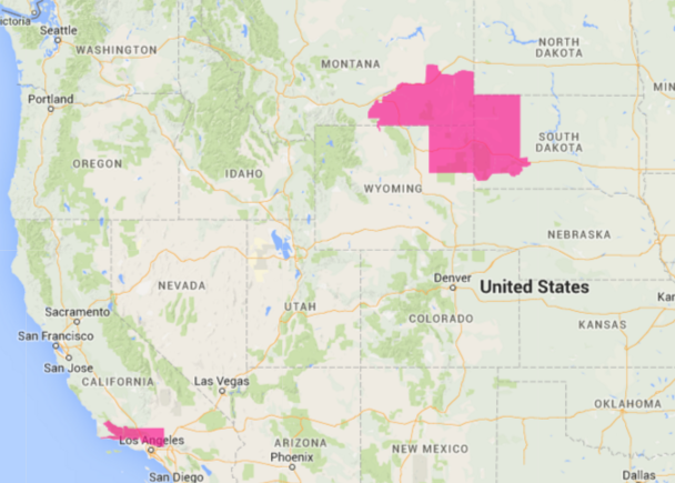
Red Flag Warnings, July 23, 2016

Screen Shot 2016-07-23 at 12.44.28 PM

The National Weather Service has posted Red Flag Warnings for areas in Southern California, Wyoming, Montana and South Dakota.

The maps were current as of 10:36 a.m. MDT on Saturday. Red Flag Warnings can change throughout the day as the National Weather Service offices around the country update and revise their forecasts and maps. For the most current data visit this NWS site.

Red Flag Warnings July 22, 2016

Red Flag Warnings July 22, 2016The National Weather Service has posted Red Flag Warnings or Fire Weather Watches for areas in California,  Washington, Wyoming, Montana, and Idaho.

The maps were current as of 7:20 a.m. MDT on Friday. Red Flag Warnings can change throughout the day as the National Weather Service offices around the country update and revise their forecasts and maps. For the most current data visit this NWS site.