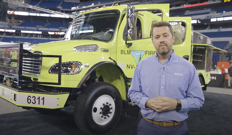
Pierce Manufacturing has produced a video walk around of the Bureau of Land Management’s Freightliner wildland fire Type 3 heavy fire engine, escorted by Scott Kiernan, Chief Engineer at Pierce. The apparatus is designed to carry 3,000 pounds of equipment, 800 gallons of water, and 20 gallons of foam. The rear-mounted pump is driven with a separate engine.
New BLM Engine 6311, rear of cabin. Image from Pierce video.
Due to previous fatal rollovers, the BLM wanted a safe cab. The new engine is equipped with side roll protection and public service vehicle (PSV) seats. The roll cage maintains the cab structure in the event of a rollover crash. The vertical framework structure integrated into the body and subframe can withstand a 60,000 pound static load and will not deflect below the cab height in a crash.
Example of data from satellite-based location reports, Caldor Fire, September, 2021. Dingell Act Resource Tracking (DART) team image.
In September during the late stages of the Caldor Fire which burned about a quarter-million acres near South Lake Tahoe, California an interagency team conducted a pilot deployment of location tracking and common operating picture technologies. They tested three different systems that track hardware mounted on vehicles or carried by personnel. They also evaluated real time video shot by an aircraft and made instantly available to firefighters. Other pilot projects were conducted on the Tussock Fire in Arizona in May, and the Tamarack Fire which burned from California into Nevada in July.
These two categories of information comprise what we have called the Holy Grail of Wildland Firefighter Safety — knowing the real time location of the fire and firefighters. Dozens, if not more, firefighters have been killed when this information was not known. If you think about firefighter entrapments, many could have been prevented if, for example, the Crew Boss, Division Supervisor, or Safety Officer had access to this real time situational awareness information.
Tracking fire resources
Legislation passed March 12, 2019 addressed this issue. The John D. Dingell, Jr. Conservation, Management, and Recreation Act mandated that the *five federal land management agencies “jointly develop and operate a tracking system to remotely locate the positions of fire resources for use by wildland firefighters, including, at a minimum, any fire resources assigned to Federal type 1 wildland fire incident management teams”, due by March 12, 2021.
Tracker (white box) installed on BLM engine. BLM photo.
The Bureau of Land Management has installed hardware for Location Based Services (LBS) which are now operational on more than 700 wildland fire engines, crew transports, and support vehicles. Vehicle position and utilization data are visually displayed via a web-based portal or mobile device application.
“The LBS system has been implemented program wide and used successfully during the 2021 fire year by wildland fire managers and dispatchers to view nearly real time locations of BLM firefighting vehicles,” said Jessica Gardetto, BLM Chief of External Affairs. “The system and its viewer are gaining widespread use, especially as LBS data is visible in the Enterprise Geospatial Portal (EGP). EGP is widely used in dispatch centers and by fire managers to display wildland fire information viewable by multiple agencies and accessible by all cooperators.”
The US Forest Service is thinking about it.
“Based on the results of these pilot programs, strategies are being prepared for the adoption of tracking units for all agency-owned or operated incident vehicles and interagency hotshot crews,” said Stanton Florea, Fire Communications Specialist for the Forest Service.
We asked the Forest Service if they had installed any tracking units, and if so how many, and did not receive an answer by publication.
(UPDATE December 10, 2021. Wildfire Today received additional information from Mr. Florea today. He said the Angeles National Forest in Southern California has installed location trackers on engines and other fire vehicles. He explained that, “The USDA Forest Service and its Dept. of Interior partners are working on developing an investment proposal to support the acquisition and operation of a system.”)
Real time mapping or video
A requirement of the Dingell Act was that was due by September 12, 2019 was to “…develop consistent protocols and plans for the use on wildland fires of unmanned aircraft system technologies, including for the development of real-time maps of the location of wildland fires.”
We asked Ms. Gardetto about the status of real time mapping. She said the agency has developed plans and protocols for real-time mapping processes, “but they remain constrained by connectivity in remote locations. Real-time mapping capacity is dependent on the availability of technology and subsequent deliverables, though again, real-time mapping services by UAS are not generally requested by incident management teams or fire management personnel.”
If the service does not exist, it is unlikely that any firefighting resources are going to request it during an incident.
We asked the US Forest Service about the status of providing real time mapping to firefighters on the ground and did not receive an answer by the time of publication.
(UPDATE December 10, 2021. Wildfire Today received additional information from Mr. Florea today. He mentioned, as we described below, the pilot deployment on the Caldor Fire of a military aircraft with Distributed Real Time Infrared (DRTI) live video. There was no indication of widespread or routine deployment of real time video.)
Findings from the pilot deployment on the Caldor Fire
The pilot deployment on the Caldor Fire of common operating picture technologies showed that the technology exists, and it is a matter of selecting the hardware and support systems that can make the information available to firefighters.
It is impressive from a technological perspective. The three tracking systems they worked with were:
Everywhere Hub devices: Garmin inReach® Mini and inReach® SE+ send the data to the Enterprise Geospatial Portal (EGP) for viewing in a variety of tracking systems.
Team Awareness Kit (TAK). A smartphone app that uses a phone’s GPS to track its user’s location, and displays the locations of other TAK app users.
Vehicle trackers on BLM fire apparatus. Uses both cellular and satellite connections to send the vehicle’s location to the EGP.
On the Caldor Fire a military aircraft with Distributed Real Time Infrared (DRTI) program also was deployed and provided fire managers with the only source of live aerial video. DRTI is a collaboration between the U.S. Forest Service and the Air National Guard. This program provides real-time intelligence to fire managers using Air National Guard RC-26 aircraft equipped with high resolution thermal infrared and visible light cameras. These aircraft downlink a live video stream of wildland fires to National Guard soldiers on the ground, who can receive the video on a handheld military ROVER radio and display it on a tablet or television screen for fire managers to view.
DART focused on issuing Everywhere Hub devices to specific divisions on the east zone of the Caldor Fire in an attempt to saturate areas of fireline, ensuring that as many resources as possible in the areas were tracked. A total of 185,382 position reports were received during the 14-day DART deployment on the Caldor Fire.
Elon Musk’s Starlink system
Starlink satellite dish providing internet service on the Caldor Fire. BLM photo.
The new technologies used included Starlink, a system developed by an Elon Musk company to eventually provide internet connectivity virtually anywhere in the world via a 23-inch satellite dish. (There is a newer version that is smaller and lighter, 12 by 19 inches weighing in at only 9.2 pounds.) The dish was tested by DART as a means to provide high-speed, low-latency internet service to remote areas of the Caldor Fire. They also used a Jagwire Server, which serves the aircraft’s live video stream to firefighters over cellular internet, and the Android Team Awareness Kit (ATAK) with an Unmanned Aerial System (UAS) Tool plugin. Speeds of 100-200 mbps down and 30 mbps up were found at the Starlink Dish.
*Five federal land management agencies involved in wildland fire are National Park Service, Fish and Wildlife Service, Bureau of Indian Affairs, Bureau of Land Management, and Forest Service.
Shows climate change has driven a significant increase in Australia’s forest fire activity over the last three decades
Climate change factors, wildfire weather and activity. From the research.
From CSIRO
A lengthening of the fire season towards Autumn and Winter was identified, along with an increase in fire activity in cooler and warmer regions including alpine forests in Tasmania and tropical rainforests in Queensland.
The research published in Nature Communications is the first of its kind and combines analysis of previous forest fire sites with eight drivers of fire activity including climate, fuel accumulation, ignition, and management (prescribed burning).
Thirty-two years of satellite data and 90 years of ground-based datasets from climate and weather observations, and simulated fuel loads for Australian forests, formed the basis of the research, which allowed researchers to identify climate change driven increases versus natural variability.
CSIRO scientist, Dr. Pep Canadell, said the research was one of the most extensive studies of its kind performed to date, and was important for understanding how continued changes to the climate might impact future fire activity.
“While all eight drivers of fire-activity played varying roles in influencing forest fires, climate was the overwhelming factor driving fire-activity,” Dr Canadell said.
“The results also suggest the frequency of forest megafires are likely to continue under future projected climate change.”
Over the last 90 years, three of the four mega fire years occurred after the year 2000. A mega fire year is defined as the cumulative burned area of forest over one year of more than 1 million hectares.
Australia’s mean temperature has increased by 1.4 degrees Celsius since 1910, with a rapid increase in extreme heat events, while rainfall has declined in the southern and eastern regions of the continent. Globally fire activity is decreasing, however, the extent of forest fires in Australia is increasing.
Burned area, whole of continental Australia including Tasmania, linear fit. From the research.
When comparing the first half (1988 – 2001) with the second half (2002-2018) of the record studied, the research showed that the average annual forest burned area in Australia increased 350 per cent, and 800 per cent when including 2019.
Comparing the same time period, the research showed a five-fold increase in annual average burned area in winter and a three-fold increase in Autumn, with Spring and Summer seeing a ten-fold increase.
“In Australia, fire frequency has increased rapidly in some areas and there are now regions in the southeast and south with fire intervals shorter than 20 years. This is significant because it means some types of vegetation won’t reach maturity and this could put ecosystems at risk,” Dr Canadell said.
“Understanding these trends will help to inform emergency management, health, infrastructure, natural resource management and conservation.”
Bushfire. Courtesy of CSIRO.
The research was conducted by J. G. Canadell, C. P. Meyer, G. D. Cook, et al.
In February and March high fire potential expected for Southern Plains, Southeast Colorado, and Eastern New Mexico
The forecast for wildland fire potential issued December 1 by the National Interagency Fire Center predicts that the December potential for wildfires will be higher than average in Central Montana, Hawaii, and the coastal areas of Georgia and the Carolinas. By February and March the fire danger will be higher than average across eastern New Mexico, west Texas, western Oklahoma, southeast Colorado, and western Kansas.
The data from NIFC shown here represents the cumulative forecasts of the ten Geographic Area Predictive Services Units and the National Predictive Services Unit.
Temperatures far above average have been breaking records the last few days across much of the West, but especially in Oregon, Washington, Idaho, Montana, and the Dakotas. The heat combined with strong winds has resulted in a number of wildfires in Montana on Tuesday and Wednesday of this week.
Below:
An excerpt from the NIFC narrative report for the next several months;
Additional NIFC monthly graphical outlooks;
NOAA’s three-month temperature and precipitation forecasts;
Drought Monitor;
Keetch-Byram Drought Index.
“Climate outlooks for winter indicate above normal temperatures are likely along the southern tier of the CONUS, with the highest probabilities likely in the Southeast. Below normal temperatures and above normal precipitation remain expected across the Pacific Northwest and through portions of the northern Rockies and northern High Plains. The Great Lakes is also likely to experience above normal precipitation through February. Below normal precipitation will likely accompany above normal temperatures across the southern half to one-third of the western US, through much of Texas, along the Gulf Coast, and into the Carolinas.
“Above normal significant fire potential will continue on the plains of central and eastern Montana in December as this area remains snow-free with periodic dry and windy conditions. Additionally, leeward sides of the Hawai’ian Islands and the Coastal Plain in the Carolinas and Georgia are forecast to have above normal significant fire potential in December. Through winter, above normal significant fire potential is expected to expand into much of Florida and Georgia, while returning to normal potential in the Carolinas.
“Critical fire weather could bring periods of elevated fire potential to the southern Plains in December and January. However, there is greater confidence in above normal significant fire potential emerging by February across eastern New Mexico, west Texas, western Oklahoma, southeast Colorado, and western Kansas. Above normal potential is likely to expand eastward across Texas and Oklahoma and to lower elevations in southeast Arizona and southern New Mexico during March. This above normal potential will be acute during wind-driven events.”
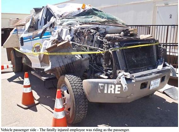
Department of the Interior, Bureau of Indian Affair engine rollover fatality that occurred June 9, 2012 on the Montezuma Fire in Arizona. Killed in the accident was the BIA engine boss Anthony Polk, 31, of Yuma, Arizona. Two crewmembers were injured, one very seriously. Photo from the report.
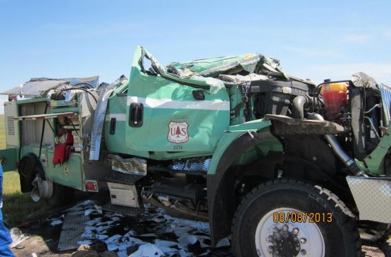
In 2009 we started to notice that rollovers of fire apparatus was far too common, and too often resulted in death or serious injuries. By July 17, 2015 we had reported on 17 rollovers of fire vehicles responding to or working on wildland fires that resulted in 44 injuries or fatalities to firefighters working on or responding to a wildland fire. That does not include non-rollover vehicle accidents, rollovers of heavy equipment (of which there were quite a few), or accidents that occurred in Australia and Canada. By that date we had had enough, and wrote an article that strongly advocated rollover protection be added to wildland fire engines, Fire vehicle rollovers — how serious a problem is it?
By Carrie Bilbao, BLM Fire Public Affairs Specialist
The BLM National Fire Equipment program (NFEP) located at the National Interagency Fire Center (NIFC) in Boise, Idaho provides standardized wildland fire engines, crew carriers, helitack support vehicles, command vehicles, bulldozers, and other specialized wildland fire apparatus to four agencies in the U.S. Department of Interior.
Following a fatal traffic accident in July 2016 that tragically took the lives of two BLM firefighters when their wildland fire engine was involved in a single-vehicle rollover, the national fire equipment and fire and aviation contracting programs began extensive research on rollover protection systems (ROPS). When they started working with private industry, there were no manufacturers developing ROPS for heavy trucks. Initially, NFEP and BLM Fire contracting educated the manufacturers and private industry that there is a need to invest in a ROPS to protect our field firefighters. Then they started working with private industry and truck manufacturers to design and test ROPS.
Roll bar protection was installed in new BLM Fire engines at NIFC in August 2021. Photo by Carrie Bilbao, BLM.
The safety features of ROPS include seats with side impact airbags, seatbelt pre-tension system, and internal roll cage. The new seat system senses a rollover event and releases air from the seat and retracts the seatbelt to pull the occupants to the lowest seating position and secures them to the seat, all in fractions of a second. This increases the crush area above their heads and protects them from projecting forward. The airbag also deploys, which gives the occupants protection in the roll. The internal roll cage provides stability to the chassis to prevent it from collapsing, potentially crushing firefighters inside in the event of a rollover accident. A “superstructure” is also integrated into the fire body. It is designed to increase the cab crush angle, providing more survivable space for the occupants. The superstructure, new seats, and roll cage will provide the wildland fire community with the safest cab ever. The NFEP’s development and integration of this technology will benefit the entire wildland fire community.
Seats equipped with side impact airbag and seatbelt pre-tension system will better protect firefighters. Photo by Carrie Bilbao, BLM.Tilt testing on a new Fort Apache Hotshots crew carrier. Photo by Mike Hislop, BLM.
“While firefighter safety is at the forefront of everything we do, it is inherently a dangerous job,” said Elden Alexander, the BLM National Fire Equipment program manager. “On a single fire dispatch, fire resources can respond 100 miles on the highway, traverse steep mountain roads, and then transition to using equipment off-road while suppressing fire. This new design adds an extra feature to keep firefighters safe. We are extremely proud of what we have accomplished and are already looking forward to the next phases of safety systems in the rest of our fire fleet. Simply said, we aren’t done yet.”
In 2021, the NFEP retrofitted 14 heavy engines with the newly developed ROPS. In the future, ROPS will be added to each contract and will be built by the manufacturer prior to being issued to the field. The outstanding work on ROPS will greatly improve the crashworthiness and survivability of our off-road wildland fire engines for all wildland fire engine personnel and will set a new industry standard. Integrating additional cab protection in all BLM Fire apparatus including crew carriers, water tenders, and dozer transports remains a priority for NFEP. The advancement in ROPS safety technology will benefit not only the U.S. Department of Interior fire programs, but well beyond them.
For the outstanding work done on research and development of this innovative safety feature, the NFEP and BLM FAD contracting recently received the DOI Safety and Health Award of Excellence. This award recognizes individuals or groups who have performed an outstanding service or have contributed unusual value to the occupational safety and health of employees, visitors, and volunteers.
The person who was awarded a patent in 2017 for describing a system of drones that could be used to drop liquids on wildfires wrote a paper earlier this year with two other authors that claims to have determined how many drones would be needed for suppressing a small section of a fire.
The patent, #WO2017208272A1, awarded to Marco Ghio, is quite vague and does not supply any technical details. It says that instead of applying fire retardant or water in a conventional manner, a “rain” concept would be used:
Dropping small quantities of firefighting liquid or drizzling it over the fire, and its subsequent spreading on a large area instead of in a concentrated manner. This method, both theoretically and experimentally, is acknowledged as being particularly effective, whereas, on a practical level, it is effectively used in domestic and/or industrial firefighting systems.
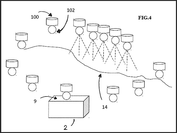
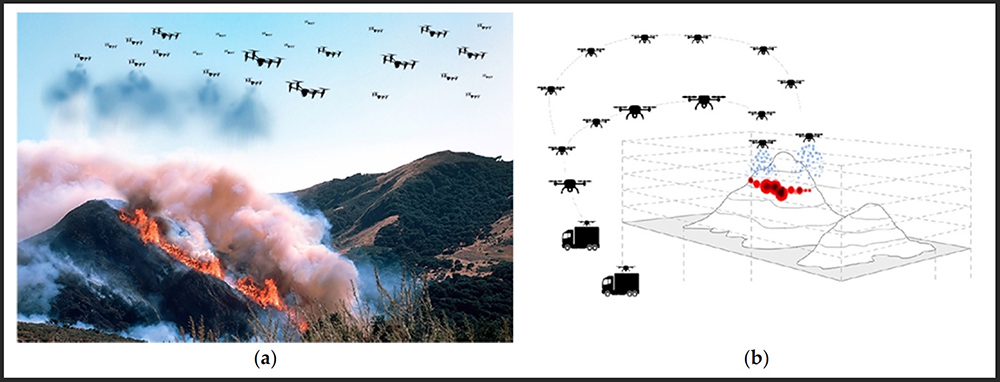
Figure 1. (a,b) Representations of the proposed firefighting system based on the use of a swarm of collaborative UAVs. (From the research)
In the United States fire retardant dropped from an approved air tanker is applied at coverage levels ranging from 1 to 9 gallons per 100 square feet, depending on the situation. It is not clear what coverage level “rain” would produce.
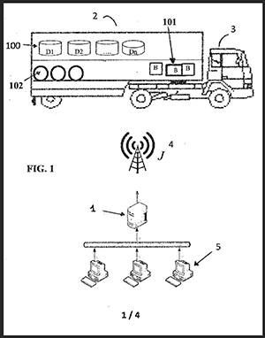
Drawing from the patent
The patent specifies that drones would transport the liquid in removable containers. Upon returning empty to the mobile base the containers would be autonomously replaced with full containers, along with a charged battery if needed.
The drones and the other equipment would be transported in standard metal shipping containers which would be strategically positioned. The system would include “a control unit for the coordination of missions, the flight paths to be followed, and the selection of the ideal drop points optimized according to the environmental conditions.”
Details about how all of this would be accomplished are not specified.
The patent and the research paper written by Mr. Ghio, Elena Ausonio, and Patrizia Bagnerini assumes that the cargo capacity of the drones would be 5 to 50 liters (1 to 13 gallons), much less than currently carried by helicopters (up to 3,000 gallons) and fixed wing aircraft (up to 17,500 gallons) that routinely fight wildfires.
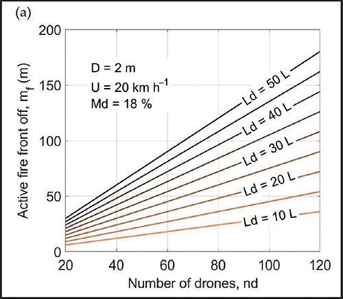
Their analysis (below) takes into account wind speed, flame length, the length of fire line to be suppressed, and the dead fuel moisture. It indicates that about 75 linear meters (246 feet) of the fire’s edge could be extinguished with 120 drones each carrying 20 liters (5 gallons) or 80 drones carrying 30 liters (8 gallons). The vegetation is assumed to be grass or brush, but not timber. The example below assumes that the wind speed is 20 km/hour (12 mph) and the dead fuel moisture is 18 percent. A moisture content of 18 percent for 1-hour and 10-hour time lag fuels is quite high for a very active wildfire. It should not be very difficult to suppress a fire under those fuel conditions.
Figure 4a shows the linear meters of fire that can be arrested by using the firefighting system. For example, approximately 70–75 linear meters of active front can be extinguished with 120 drones each carrying 20 L or with 80 drones carrying 30 L. Assumptions are that the wind speed is 20 km/hour and the dead fuel moisture is 18 percent. (from the research)
Our take
In my opinion the most difficult part of using drones to assist firefighters would be applying the retardant or water at the exact location where it can be useful. That is difficult enough when you have good communication with ground personnel, adequate aerial supervision, and experienced highly qualified air crews in helicopters or air tankers.
I don’t think the principle of “rain” in the application of retardant or water from dozens or hundreds of drones is a thing, at least when you’re talking about drones that can just carry a few gallons of water and must have the batteries replaced every 20 minutes. The suppressant still has to be delivered in a timely manner in a quantity and at the location where it can be useful. Maybe when drones are carrying 50 to 100 gallons of water, and the technology improves for placing the retardant on target, it might be useful in very remote areas when the fire is very small, less than 1/10 of an acre, and the wind speed does not exceed 5 mph.
Rain Industries is working on an Unmanned Aerial System (UAS) that could carry up to 400 pounds of cargo, or 50 gallons of water.
Drone Amplified, the developer of the IGNIS prescribed fire system currently being used for aerial ignition, and Parallel Flight Technologies, have received a $650,000 grant from the US Department of Agriculture to support further development of a large-scale Unmanned Aerial System (UAS) for prescribed fire. Parallel says their hybrid gas/electric UAS can carry 100 pounds for up to two hours, numbers that are much larger than battery operated drones. When paired with the upgraded aerial ignition payload under development which will hold and dispense 3,500 incendiary spheres, it will have eight times the payload carrying capacity of drones being used today, and ten times the flight duration.