Oldest know charred pine fossil found

The fossil of a pine tree was preserved as charcoal within rocks in Nova Scotia

From the BBC:

****

“The charred pine twigs date back 140 million years to a time when fires raged across large tracts of land. Pine trees now dominate the forests of the Northern Hemisphere.

fossilized pine twig
False color image of the fossilized pine twig that is a few milimeters long. Photo by H. Falcon-Lang.

The research suggests the tree’s evolution was shaped in the fiery landscape of the Cretaceous, where oxygen levels were much higher than today, fuelling intense and frequent wildfires.

“Pines are well adapted to fire today,” said Dr Howard Falcon-Lang of Royal Holloway, University of London, who discovered the fossils in Nova Scotia, Canada.

“The fossils show that wildfires raged through the earliest pine forests and probably shaped the evolution of this important tree.”

Serendipitous find
The specimens, which are described in Geology journal, were preserved as charcoal within rocks from a quarry.

“It was only when I digested [the samples] in acid that these beautiful fossils fell out,” Dr Falcon-Lang told BBC News.

“They were sitting in my cupboard for five years before I actually worked out what was there.”

Plant oddities
The fossils are just a few mm long but probably came from trees resembling the Scots Pine that now cover large areas of Scotland.

“One of the oddities about pine trees today is that they are one of the most fire adapted species on our planet,” explained Dr Falcon-Lang.

“These oldest pine fossils are preserved as charcoal, the product of fire, suggesting that the co-occurrence of fire and pines is something that’s very ancient, that goes back to the very origin of these first pine trees.”

Dr Falcon-Lang plans to return to the quarry this summer to recover more specimens.”

Thanks and a tip of the hat go out to Matthew.

Sky lantern starts wildfire in Colorado

Report says three sky lanterns were released — one started a fire.

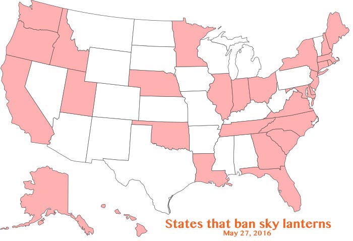
sky lanterns banned states

There is a report that a sky lantern started a wildfire in Colorado on Saturday, March 12. A writer on Pinecam.com said that between 11:00 and 11:45 p.m. one of three of the devices that were released landed in vegetation and started a small brush fire. It occurred near Pine Grove, which is another name for Pine, Colorado. (map)

If this had happened in August rather than March, we might be writing a different story. The town is at 6,700 feet elevation, so there’s a good chance that the fuels are still somewhat wet or there could be snow. Nearby ridges are at 7,000 to 8,000 feet.

Sky lanterns were blamed for starting other fires just last month. One near Sun Prairie, Wisconsin burned 15 acres and another is thought to have ignited a four-plex structure in Santa Rosa, California.

Sky lanterns are banned statewide in 30 states, but not in Colorado.

These devices are small plastic or paper-covered hot air balloons powered by an open flame. They can travel uncontrolled for more than a mile, sometimes landing while the fire is still burning.

Articles on Wildfire Today tagged sky lantern.

Thanks and a tip of the hat go out to Allen.

Poll: which fire weather mapping product do you prefer?

Fire weather 3-14-2016

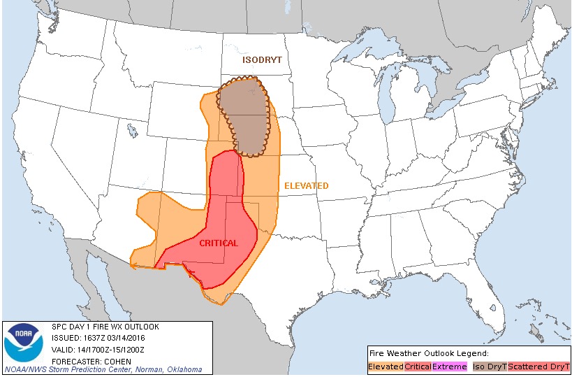
Today we have two very different fire weather mapping products. Both provide information about the predicted fire weather for today, March 14.

The map above is produced by the Storm Prediction Center in Norman, Oklahoma. It does not display Red Flag Warnings or Fire Weather Watches. Instead, it designates areas with “critical” and “elevated” fire weather forecasts. It also shows an area in South Dakota and Nebraska that has the possibility of “Iso DryT” — isolated dry thunderstorms. We checked the more detailed text fire weather forecasts for the Iso DryT areas and only found one that briefly mentioned that issue.

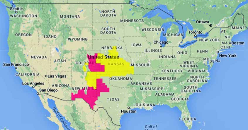
Below is the type of map that we have been using for years on Wildfire Today. It only provides information about Red Flag Warnings or Fire Weather Watches — which is good to know. Especially if you want to supply information to the public using just a few words that can convey an important message.

Both maps can be found HERE.

wildfire Red Flags 3-14-2016

Which map do you prefer us to use on Wildfire Today? Let us know by choosing an answer in the poll below — then click on the hard to see “vote” box below.

Which fire weather map do you prefer for Wildfire Today?

View Results

Loading ... Loading ...

Wildland fire emissions worse in polluted areas

Posted on Categories Uncategorized

A University of California Riverside study shows biomass grown in areas of poor air quality releases more pollutants when burned than biomass grown in clean air.

Above: Smoky conditions on the Pleasant Valley Prescribed Fire west of Pringle, SD, March 10, 2016. Photo by Bill Gabbert.

When plant matter burns, it releases a complex mixture of gases and aerosols into the atmosphere. In forests subject to air pollution, these emissions may be more toxic than in areas of good air quality, according to a new study by the University of California, Riverside and the U.S. Forest Service’s Pacific Southwest Research Station.

The results suggest biomass burning of polluted forest fuels may exacerbate poor air quality—and related health concerns—in some of the world’s most heavily polluted areas, among them, the Los Angeles metropolitan area, which is expected to suffer from more wildfires as drought conditions continue.

The study, which was led by Akua Asa-Awuku, a researcher at the Center for Environmental Research and Technology (CE-CERT) at UC Riverside’s Bourns College of Engineering, was published March 2 in the journal Environmental Research Letters.

As people burn fuels—in cars, power plants and factories—nitrogen is released into the atmosphere and absorbed by plants. While essential for plant growth, an over-abundance of this biologically-available nitrogen can result in ‘nitrogen saturation,’ a phenomenon previously reported by Forest Service scientists in Riverside.  Nitrogen saturation can cause a cascade of adverse effects including a decrease in biodiversity, changes in plant species, soil acidification and water contamination.

In this paper, UCR and Forest Service researchers teamed up to explore a previously unstudied aspect of nitrogen saturation: its effect on the gases and aerosols released during burning of forest fuels from an area experiencing nitrogen saturation.

Scientists conducted the study in the San Bernardino Mountains, a 60-mile stretch of federal and private forest land to the east of the Los Angeles metropolitan area. Since the pollution concentration decreases from west to east, as the distance from Los Angeles increases, the forests offered a rare opportunity to compare emissions from wildland fuels subjected to different levels of chronic air pollution. At sites 55 miles apart, the researchers collected recently deposited material from the forest floor, called litter, which is a primary fuel in these forests. Both sites have a similar mixture of conifer tree species, and, at the time of collection, had experienced similar temperatures and rainfall.

As shown in previous studies, the litter from the polluted site, which had endured high levels of atmospheric nitrogen oxides and ozone, had higher nitrogen content than litter from the clean site. The researchers then burned the litter in controlled lab tests, collected the emissions and analyzed them. The results showed:

  • Fuel from the polluted site released more nitrogen oxides, which contribute to the formation of smog and ozone. In some cases, polluted fuels released 30 percent more nitrogen oxides than fuels from the clean site.
  • Polluted fuels released more small fine particles (PM<2.5), which are known cause of respiratory health problems.
  • The composition of the particles from polluted regions were different; they were less likely to evaporate but underwent similar atmospheric processing as emissions from clean fuels exposed to sunlight.

Continue reading “Wildland fire emissions worse in polluted areas”

Prediction for winds gusting to 50 mph raise Red Flag Warnings in New Mexico

The National Weather Service has issued Red Flag Warnings for areas in New Mexico and western Texas. The forecast calls for strong winds Saturday afternoon gusting up to 50 mph with relative humidities in the low teens or single digits.

The predicted red flag conditions mysteriously stop at the eastern and northern New Mexico border and don’t occur in Texas, Oklahoma, or Colorado except further south in the part of west Texas that is south of New Mexico. The same thing occurs to a lesser extent in southwest New Mexico where the red flag warnings in New Mexico are not in the forecast for Arizona across the imaginary line between the states. Examples of this phenomenon are tagged “red flag borders” on Wildfire Today.

The map was current as of 9:25 a.m. MDT on Saturday. Red Flag Warnings can change throughout the day as the National Weather Service offices around the country update and revise their forecasts and maps. For the most current data visit this NWS site.

Connecticut volunteer firefighters arrested for arson

Posted on Categories UncategorizedTags

In a television interview, one of them apologized but did not admit setting the fire.

firefighter arson David G. Korot Vincenzo M. Marino
David G. Korot (left) and Vincenzo M. Marino

Two volunteer firefighters, David Korot, 19, and 21-year old Vincenzo Marino, firefirefighters with the Drakesville Volunteer Fire Department in Connecticut were arrested Wednesday night and charged setting a wildland fire that burned 14 acres near Torrington. Both were released on $5,000 bonds and are scheduled to face a judge in Bantam Superior Court on March 28.

Mr. Marino appears in the video below, probably much to the chagrin of his attorney, if he is smart enough to obtain one.