Report concludes that USFS should revise fire protection agreement with CAL FIRE

An audit conducted by the U.S. Department of Agriculture’s Office of Inspector General concluded that the U.S. Forest Service has assumed a disproportionate share of the fire suppression burden specified in interagency agreements with the California Department of Forestry and Fire Protection (CAL FIRE).

The USFS enters into fire protection agreements with other land management agencies when, after evaluating geography and the location of fire suppression resources, it appears to make economic sense that Agency A protect portions of Agency B’s lands in some areas, and vice versa. But there are inherent differences, on a broad scale, between the National Forests in California and lands CAL FIRE is charged to protect. The private property has more people and structures on or close it, therefore more wildland-urban interface (WUI). When fires approach or burn private property and homes in a WUI, it historically has generated a much more aggressive and expensive response than fires in a typical USFS forested area. While the acres exchanged in these agreements may on the surface appear to be more or less equal, the responsibility to protect them from wildfires can be very different — and more costly.

State lands in California near National Forests generally have more grass, brush, and WUI areas than Forest land in the same general area. The table below, from the IG report, shows the difference in costs for putting out fires in the three different types of fuel.

Fire Suppression costs per acre

The Inspector General found that in California, the USFS has assumed responsibility for protecting almost 2.8 million acres of private land, exchanging the protection of land that is inexpensive for land that is more difficult, and therefore more expensive, for example WUI areas near forests. State officials, according to the report, took responsibility for
land that was comparatively inexpensive to protect, such as grassland.

The Inspector General recommends that the USFS reassess its fire protection responsibilities with CAL FIRE.

In addition to the inequalities regarding areas that are protected, the Inspector General uncovered other issues:

OIG also found that local cooperators used indirect cost rates for firefighting activities that may have been excessive and unreasonable. FS did not safeguard its assets by establishing policies and procedures to review indirect cost rates charged by local cooperators. As a result, we questioned over $4.5 million in administrative costs paid to nine cooperators in California. In addition, FS overpaid $6.5 million to Colorado State University for unallowable administrative costs during a 4-year period. Although FS identified this issue and ceased future overpayments, it has not recovered the overpayments.

On a side note, the illustrations on the cover of the USDA Inspector General’s report, emphasizing radishes, chickens, and carrots, shows how land management and the suppression of wildfires seems to be an afterthought within the Department even when issuing a report about firefighting. IG report coverThis is in spite of the fact that the USFS spends about $1.2 billion annually on fire suppression, which consumed 52 percent of its budget in fiscal year 2015. The five major federal land management agencies in the USDA and Department of the Interior employ over 13,000 wildland firefighters, a group of employees that should be difficult to overlook, but often is.

This prompts us once again to think about how things might be different if all of the federal land management agencies, or perhaps only their fire departments, were in a stand-alone agency, emphasizing at number one, fire protection, rather than radishes.

Thanks and a tip of the hat go out to Tom.

Throwback Thursday: remember this prescribed fire at Malheur?

Revisiting an article from February 27, 2014

Rx fire at Malheur Nat'l wildlife Refuge. USFS photo by Shane Theall.
Prescribed fire at Malheur Nat’l wildlife Refuge. USFS photo by Shane Theall.

According to the U.S. Fish and Wildlife Service. their….

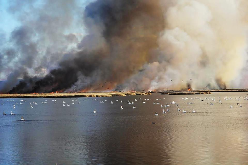
Malheur Fire Program and the Burns Interagency Fire Zone conducted a 2,250-acre prescribed fire on the Deer Park Unit of Malheur National Wildlife Refuge this week [late February, 2014]. Located in southeastern Oregon’s high desert, at the northern end of the Great Basin, the 187,000-acre National Wildlife Refuge is famous for its spectacular concentrations of wildlife. With its abundant water resources in an otherwise arid landscape, the Refuge hosts more than 320 bird species and 58 mammal species.

Rx fire at Malheur Nat'l Wildlife Refuge. USFWS photo by Carla Burnside.
Prescribed fire at Malheur Nat’l Wildlife Refuge. USFWS photo by Carla Burnside.

Changes at the state fire chief positions in Colorado and Montana

There will be transitions at the top of the state wildfire organizations in Colorado and Montana.

In Colorado, Paul Cooke, the Director of the Division of Fire Prevention and Control, is retiring. He became the Director in 2012 after the Colorado legislature and Governor Hickenlooper made major changes in the organization and structure of state-level fire and life safety programs. Chief Cooke will remain in the position until his successor is appointed and onboard.

In Montana the Department of Natural Resources & Conservation (DNRC) recently selected Mike DeGrosky as the new Fire and Aviation Bureau Chief following the retirement of Ted Mead in December. The Fire and Aviation Management Bureau provides resources, leadership and coordination to Montana’s wildland fire services to protect lives, property, and natural resources; working with local, tribal, state, and federal partners to ensure wildfire protection on all state and private land in Montana.

“Our effort to involve a number of DNRC staff members as well as external partners was met with support and enthusiastic participation across the state, and I found it both rewarding and inspiring to see so many people engaged in the process. We offered Mike DeGrosky the position and he accepted enthusiastically. The DNRC welcomes Mike and is excited to have him join our team,” said Bob Harrington, Forestry Division Administrator.

Mike comes back to DNRC with over 38 years of wildland fire and incident management experience as well as extensive experience in facilitation, consulting, and conflict resolution experience in wildland fire and natural resource organizations.

From 1982-1995 Mike worked for the DNRC in various positions including Rural Fire Forester, Fire Management Specialist, Unit Fire Supervisor and Fire Program Manager. Other services and roles in his career include Volunteer Fire Department Captain, Training Officer, and consultant to fire and emergency management organizations.

DeGrosky is a graduate of the University of Montana, College of Forestry and Conservation, holds a Master’s degree in organizational leadership from Fort Hays State University, and a PhD in Business Administration with an emphasis in organizational leadership from Northcentral University.

“I am looking forward to working with each of you. I will put a high priority on getting out and meeting local officials, fire service organizations and agency partners. I am pleased to be back with the Department and look forward to our work together,” DeGrosky said.

He began working part-time in late January and will assume the duties as Chief full time on February 8, 2016.

Sky lantern ignites fire in California four-plex; Oregon may strengthen their ban

Sky Lantern poster

Investigators determined a fire that burned a portion of a four-plex structure in Santa Rosa, California was started by a sky lantern, sometimes called a Chinese lantern.

Below is an excerpt from an article in the Press Democrat:

…Investigators suspect [the] fire started when a floating paper lantern landed on the shake roof of a four-plex on Butte Drive off Hardies Lane. Firefighters limited the fire to a small section of the room, Lowenthal said.

“We found the remnants of a sky lantern on the roof,” Lowenthal said.

He said they suspect this is the second fire caused by a sky lantern in the neighborhood south of Piner Road in recent weeks…

Meanwhile legislators in Oregon have introduced a bill that would strengthen the laws regulating sky lanterns. Presently they are banned over state protected lands during fire season.

Below is an excerpt from the Statesman Journal:

…Just last week, a sky lantern released to celebrate a wedding in New Zealand set a home on fire.

Oregon Rep. David Gomberg, D-Lincoln City, is co-sponsoring a bill to ban the lanterns. He calls them “flying Sterno cans.”

“They are very pretty. And they’re pretty dangerous,” he said.

They’re also cheap: Walmart offers a set of 10 for $15.99.

Sen. Betsy Johnson, D-Scappoose, is the other sponsor.

“Given the stressed condition of our forests, whether it’s disease or drought or mismanagement, conflagration has become a clear and present danger,” Johnson said. “I believe one of the highest responsibilities of the legislature is not to let Oregon burn down on our watch.”

Counting Oregon, sky lanterns are banned in 29 states.

If you’re still not convinced that sky lanterns should be banned, here is an article about the problems they cause in Taiwan. It includes a photo of a dead owl tangled in a sky lantern.

Evaluation of fatal explosion in West, Texas

Above image: A screen grab from the video produced by the U.S. Chemical Safety Board about the explosion in West, Texas in 2013.

You may remember the terrible fire and explosion that injured 260 people and killed 15 in the small town of West, Texas April 17, 2013. Ten firefighters died. The incident occurred at the West Fertilizer Company when 30 tons of fertilizer grade ammonium nitrate exploded after being heated by a fire at the storage and distribution facility.

The U.S. Chemical Safety Board just released this excellent video with professional quality animations explaining how it occurred. They also point out some training, zoning, and regulatory issues that if implemented may have prevented a large-scale catastrophe.

Powerline Fire burns near headquarters of Big Bend National Park

(UPDATED at 7:35 p.m. CST February 5, 2015)

Big Bend National Park reports that the 1,792-acre Powerline Fire is 98 percent contained. They will begin demobilizing firefighting resources Saturday.

****

(UPDATED at 5:42 p.m. CST February 4, 2016)

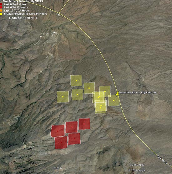
Below is an updated satellite map of the Powerline Fire in Big Bend National Park in south Texas.

Map Powerline Fire 148 pm CST 2-4-2016
Map showing heat detected by a satellite (the red squares) on the Powerline Fire at 1:48 p.m. CST February 4, 2016. The fire appears to be spreading toward the southwest.  Some areas of the fire, especially east of the road, burned and cooled between satellite over flights, and were not detected. The park headquarters and employee housing area can be seen north of the fire.

****

(UPDATED at 10:55 CST, February 4, 2016)

Powerline Fire
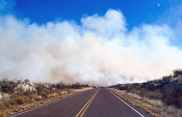
Poweline Fire in Big Bend National Park, the afternoon of February 3, 2016. NPS photo.

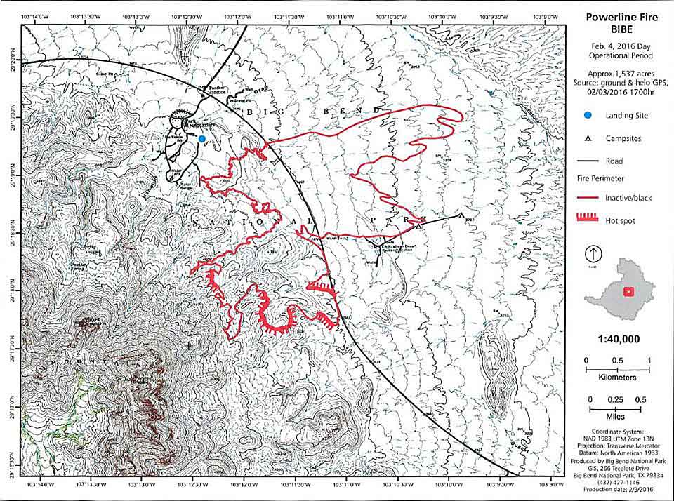
Better mapping has revealed that the Powerline Fire in Big Bend National Park in south Texas had burned 1,537 acres as of 5 p.m. CST on Wednesday, which is a revision of the earlier estimate of 1,995 acres.

Late on Wednesday the park reported that the fire had approached the southern side of the road between Panther Junction and Rio Grande Village, but it had not jumped the road since Monday February 1st and there was no active fire on the north side of the road.

Powerline Fire map
Map of the Powerline Fire for the February 4 operational period. Park Headquarters and the employee housing area are just northwest of the fire. NPS.

Continue reading “Powerline Fire burns near headquarters of Big Bend National Park”