Legislation announced to raise pay for federal wildland firefighters to at least $20 an hour

Would also pay “portal to portal” on fire assignments and provide housing stipends

3:53 p.m. MDT Oct. 19, 2021

Wildland Firefighter Classification and Pay Parity Act

Today federal legislation was announced that would benefit wildland firefighters in several ways. The Tim Hart Wildland Firefighter Classification and Pay Parity Act. (Update Oct. 26, 2021. The bill now has a number: H.R.5631 – Tim Hart Wildland Firefighter Classification and Pay Parity Act.)

The bill would increase their take home pay by raising firefighters’ salaries and would provide other benefits:

  • Raise federal wildland firefighter pay to at least $20 an hour, and add “portal-to-portal” compensation;
  • Create a federal wildland firefighter classification series, so wildland firefighters are appropriately classified for the dangerous work they are doing;
  • Provide health care and mental health services to temporary and permanent wildland firefighters, including:
    • creating a national “Federal Wildland Firefighter Cancer and Cardiovascular Disease Database” to track chronic disease caused by on the job environmental exposure throughout the lives of current and past wildland firefighters, and
    • launching a mental health awareness campaign, a mental health education and training program and an extensive peer to peer mental health support network for wildland firefighters and immediate family.
  • Ensure all federal wildland firefighters earn retirement benefits for temporary seasonal employment, retroactively applying to the last 10 years of service (this has been corrected, and applies to service since 1989;
  • Provide 1 week of mental health leave for wildland firefighters;
  • Provide housing stipends for all firefighters on duty more than 50 miles from their primary residence; and
  • Provide tuition assistance for all permanent federal employees in the wildland firefighter classification.

The bill would affect the approximately 15,000 firefighters that work for the National Park Service, Bureau of Land Management, Bureau of Indian Affairs, Fish and Wildlife Service, and Forest Service. Their salaries are far below that found in some county, state, and municipal fire departments which has resulted in an exodus of trained and experienced fire personnel to other organizations, and makes recruitment of their replacements difficult.

Currently, wildland firefighters are primarily classified as “forestry technicians,” paid an hourly wage of $13.45 at the starting GS-3 level, and are often can’t afford the costs of housing while on the job. According to recent studies, firefighters nationwide commit suicide 30 times as often as the general public and have a 30% increased risk for cardiovascular diseases, and 43% increase for lung cancer.

The proposed legislation was announced during a virtual press conference Tuesday. Speakers in support included Rep. Joe Neguse (CO) and co-sponsor Rep. Salud Carbajal (CA). Other co-sponsors include Rep. Katie Porter (CA) and Rep. Liz Cheney (WY). Mr. Neguse is Co-Chair of the Bipartisan Wildfire Caucus.

The bill is named after Tim Hart, a smokejumper who died May 24, 2021 after a hard landing while parachuting into the Eicks Fire in New Mexico. Mr. Hart’s widow, Michelle Hart, was one of the speakers at the virtual press conference, expressing her support of the legislation.

“Tim would be humbled and honored to have this legislation be a part of his legacy,” she said. “These issues were deeply important and personal to him. Wildland firefighters deserve to be recognized and compensated for the grueling conditions in which they work and for putting their lives on the line every day. This legislation is a major step forward in achieving that goal.”

The legislation has not yet been introduced, and after that step it has to make it through several committees before it can be voted on in the full House of Representatives. One of those committees, the National Parks, Forests, and Public Lands subcommittee, is chaired by Mr. Neguse who said he will arrange for a hearing on the bill.

Mr. Neguse said he was reasonably certain that a companion Senate bill will be introduced in the coming weeks.

The bill is endorsed by Grassroots Wildland Firefighters, International Association of Firefighters, U.S. Hotshots Association, National Smokejumper Association, Wildland Firefighter Foundation, Eric Marsh Foundation, National Federation of Federal Employees, and Team Rubicon.

The Grassroots Wildland Firefighters, one of the organizations that provided input as the legislation was being formulated, issued a statement on the legislation:

“We urge all members of congress to support Tim’s Act, if you represent a district impacted by wildfire or any type of natural disaster, please understand how these needed fixes impact the well-being of the men and women responding to those incidents.” said Luke Mayfield, GWF Vice President, adding that, “simultaneously Grassroots Wildland Firefighters will work to keep firefighters and their families briefed on how the bill would impact their lives.”

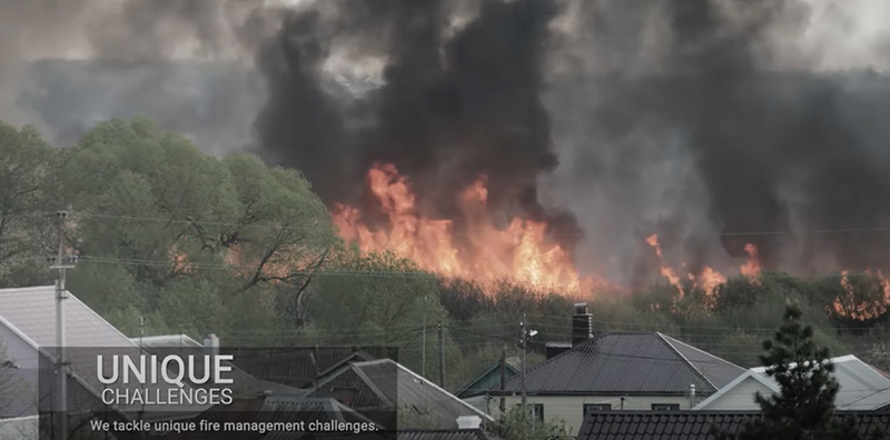
BLM produces video about their fire management activities

BLM video fire management
Still image from the BLM video below.

Yesterday the Bureau of Land Management published a slickly-produced three-minute video that is an introduction to the wildland fire management activities of the agency.

The BLM’s description of the video:

“The BLM, a leader in wildland fire management, conducts a broad range of actions to protect the public, natural landscapes, wildlife habitat, recreational areas, and other values and resources. The agency’s national fire and aviation program, BLM Fire, which focuses on public safety as its top priority, consists of fire suppression, preparedness, predictive services, vegetative fuels management, community assistance and protection, and fire prevention through education. To meet its wildland fire-related challenges, the BLM fields highly trained professional firefighters and managers who are committed to managing fire in the most effective and efficient manner.”

Method developed to predict onset of strong winds 8-10 hours in advance

Upper-air profiles detected with sodar can measure upper-air winds before they begin at the surface

Sodar system
Sodar system used in the upper-air profiler pilot test. Image courtesy of Sonoma Technology.

A team of researchers with Pyregence have developed a system for predicting when strong upper-air winds will descend to the surface 8 to 10 hours in advance. Strong wind is the environmental factor that is virtually always present during catastrophic wildfire events that destroy hundreds of structures and put thousands of residents at great risk. Fuel conditions, humidity, and topography are also important factors, but few fires become fire storms without strong winds. Predicting the onset of a wind event can affect the deployment of firefighters, the tactics they employ on existing fires, and allow better decisions about preemptive power shutoffs, community warnings, and evacuations.

A device called sodar blasts a very loud 91-decibel pulsing beep into the sky which is then scattered by atmospheric turbulence back to the sodar, allowing profile calculations of wind speed, direction, and height.

Below is an excerpt from an article at Pyregence.org:


Profilers offer distinct advantages over other data collection methods. Most upper-atmosphere weather data is collected using radiosondes, instruments carried aloft, generally by balloon, two times a day. Profilers, by contrast, gather data two or three times every hour, and they also collect more detailed information throughout the lowest levels of the atmosphere—factors that allow for more accurate forecasts.

In 2003, for example, a profiler in New Mexico detected intensifying upper-air winds that had been missed by nearby radiosonde observations. The profiler helped forecasters accurately predict a midnight wind surge, giving fire crews the information they needed to rapidly contain the spread of the fire.

“Sodars have the ability to provide information that you can’t get from other instruments, and that are not available in the surface meteorological network,” says Kenneth Craig, a Senior Atmospheric Scientist and Meteorologist with Sonoma Technology, an environmental consulting firm that conducted the study for Pyregence.

DETECTING DESCENDING WINDS

For the Pyregence pilot test, the sodar system collected data from July 25 through October 26, 2020 [north of Santa Rosa in Northern California.]

Although a number of high-wind events occurred at the site during the pilot study period, a Diablo event that developed in late September proved particularly revealing.

Between 3 and 4 p.m. on September 25, strong winds developed 300–600 meters above ground level. Then, just after 1 a.m. that night, surface wind gusts of about 35 mph were recorded. The next day saw a similar pattern: strong winds developed aloft in the mid-afternoon and then gradually descended to the surface around midnight.

Both days, that is, saw high winds develop first in the upper atmosphere and then, about 8–10 hours later, descend to the surface. That time gap offers a window of opportunity to improve wildfire preparedness, especially during active fire situations.

[…]

BETTER DATA MEANS IMPROVED FIRE FORECASTS

The Extreme Weather Team concluded that a statewide network of strategically placed upper-air profilers could improve short-term forecasts of surface winds and help scientists who model fire behavior better understand the complex interactions of the atmosphere and wildfire.

How many sodars are needed? Although the scientists who led the study cautioned that they had not conducted a detailed analysis of this issue, they indicated that a relatively small number—perhaps in the range of 10–15 sodars carefully positioned across California—could dramatically improve the ability to predict strong winds.

“You don’t have to blanket every geographic area with instruments—there’s always a balance between the cost and the benefit,” Craig says. “But a handful of strategically placed sodars would fill gaps in our observing network and provide valuable information to support situational awareness and forecasting efforts.”

Do we need a new paradigm for protecting iconic groves of remaining giant sequoias?

Can we prevent the annual loss of 10 percent of the giant sequoias

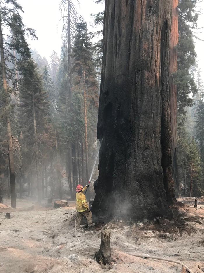
Firefighter on the Windy Fire burning giant sequoia tree
Firefighter on the Windy Fire applies water on a burning giant sequoia tree. Photo uploaded to InciWeb Oct. 11, 2021.

In 2020, 10 to 14 percent of all giant sequoias across the tree’s natural range in the Sierra Nevada that were at least four feet diameter were killed in the Castle Fire when a substantial proportion of all sequoia groves touched by the fire burned with unprecedented severity.

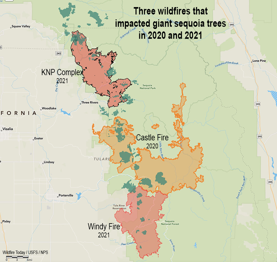
There are two fires currently burning which are destroying more of these iconic beasts of trees, the KNP Complex just north of the Castle Fire, and the Windy Fire which has spread into the south side of the Castle Fire. These three fires were primarily in the Sequoia and Kings Canyon National Parks and the Sequoia National Forest.

Three Fires, giant sequoia trees
Three fires in two years that killed giant sequoia trees. The green areas represent groves of giant sequoias.

According to a very preliminary estimate by the KNP Complex incident management team which was later removed from Facebook, “hundreds” of the iconic trees may have been killed in one day, October 4, in the Redwood Mountain Grove, the largest giant sequoia grove on Earth.

Under normal conditions giant sequoia trees can live for more than 3,000 years, which is 38 times the life expectancy of a human in the United States. The multi-year drought and higher temperatures have led to extremely dry fuel moistures which is causing wildfires in California and other areas to burn with unusual intensity, making even some of the giant sequoias with bark up to a foot thick susceptible to wildfires burning under these conditions.

KNP Complex of fires. Giant sequoias
KNP Complex of fires. Giant sequoias in the Giant Forest, posted Sept. 19, 2021. InciWeb.

It will take a few years for the final death toll to be determined in the Castle Fire, but a report released June 25, 2021 estimating the mortality found that areas which burned with high intensity, which was 30 percent of the Castle Fire grove areas, killed many giant sequoias. Below are the mortality and survival numbers from the report for the Alder Creek Grove, which shows 97.3 percent mortality in high fire severity areas, and 55.1 percent in moderate severity locations.

Giant Sequoia mortality, Alder Creek Grove, Castle Fire, 2020. NPS.

The early data for the 2020 Castle Fire translates to an estimated loss of 7,500 to 10,600 large sequoias (those with trunk diameters of four feet or more).

It could be many months or up to a year before a complete inventory determines the additional giant sequoia mortality from the fires in 2021, the Windy Fire and KNP Complex.

On October 12 the US Forest Service reported that in the Windy Fire all but four mature giant sequoias were killed in one of the smaller groves, Starvation Creek, which according to earlier information had about 30 mature sequoias. Three other groves, the FS said, had less severe damage, and four still have not been evaluated and may not be until Spring or Summer of 2022. This information only applies to the Sequoia National Forest and Giant Sequoia National Monument, and does not include the Sequoia and Kings Canyon National Parks and the KNP Complex.

Probably millions of trees are killed every year in wildfires. Should we care that 10,000 or so extremely large ones were wiped out in 2020, with trunk diameters that exceed 20 feet, that can be more than 300 feet in height and live more than 3,000 years?

These big trees are a link with our past. They represent the fact that some living things can thrive for a very long time if no one comes along to totally screw things up.

What can be done?

Fix the climate? It won’t happen quickly. The reality is that even if all of the industrialized nations overnight adopted climate-friendly policies and practices, it could be decades before CO2 and other climate gasses would decrease to the point where the climate would begin to return to pre-1850 conditions.

Harden the giant sequoia groves? Reducing the ground and ladder fuels beneath the huge trees can make them more resistant to fire. The Sequoia and Kings Canyon National Parks have been treating many of the groves with prescribed fire since the 1960s. The Sequoia National Forest also has an active prescribed fire program. But the federal agencies have not had the funding and personnel to conduct thinning and prescribed fire projects in all of the groves. And California air quality regulations and residents who complain about smoke from prescribed fires restrict the windows for when the burns can take place.

Rethink the way limited firefighting resources are allocated to going fires? In a September 23, 2021 public briefing, one of the Operations Section Chiefs on these fires explained that he did not have enough hand crews and other resources to be able to work on all of the high priority areas on his fire at the same time, and was forced to shift them around based on fire activity. It sounded like Whack-A-Mole. This was due at least in part to the numerous ongoing fires, which were competing for the same resources. Other fires had similar shortages and unfilled resource orders.

We asked Rebecca Paterson, a Public Affairs Specialist for Sequoia and Kings Canyon National Parks, if all of the resource requests or orders placed by the incident management team had been filled would there have been less giant sequoia mortality?

“It would be impossible for us to determine what could have been and we do not want to speculate,” Ms. Paterson replied.

The role of Multi-Agency Coordinating Groups in allocating scarce firefighting resources

We also asked Ms Paterson, “Beyond placing resource requests and orders, was anything else done in an attempt to procure additional resources? Such as conversations by high-ranking NPS and USFS personnel with regional and national level entities or the National Multi-Agency Coordinating Group (NMAC)?”

Ms. Paterson: “The NPS representative to the National Multiagency Coordinating Group was aware of the competing resource needs across multiple geographic areas during Preparedness Level 4 and had daily contact with the Southern California Geographic Area as their NMAC liaison. NMAC makes resource allocations to geographic areas not specific incidents. The geographic areas then assign resources to incidents. We do not know what conversations may have occurred within the United States Forest Service.”

The Operating Plan for the NMAC sets the priorities for the group when allocating resources:

  1. Protection of human life.
  2. Maintain initial attack capability.
  3. Protect communities and community infrastructure, other property and improvements, and natural and cultural resources.

The 2021 Multi-Agency  Coordination System Procedure Guide for FIRESCOPE California uses a point system for establishing priorities for resource allocation among incidents. The maximum score is 60 for each fire. Only up to 5 points can be attributed to “Natural Resources (Threatened and Endangered Species Habitat, Watershed, Forest Health, Soils, Air Shed, etc.).” Up to 15 points can be assigned to structures and infrastructure.

It is probably safe to assume that when multiple large fires are burning most of the priorities for allocating scarce resources are decided by individuals with a history of on the ground firefighting. They may or may not have a bias toward assigning fire personnel to protect buildings, rather than fires where 3,000-year old trees 300 feet tall and 20 feet in diameter are being destroyed.

Today, the last giant sequoias on Earth live on land the size of Cleveland (48,000 acres) in about 73 groves scattered along the western slopes of the Sierra Nevada. The northernmost grow in Placer County in Tahoe National Forest, and the southernmost groves are in Giant Sequoia National Monument. They need a great amount of water and depend on the Sierra snowpack that accumulates over the winter months and soaks into the ground when it melts. Years of drought, declining snowpack, and increasingly intense wildfires are putting the species at greater risk.

If these massive plants were able to already live for thousands of years, it is irresponsible to not ramp up our efforts to protect them when human-caused climate change is suddenly leading to the destruction of large segments of their populations, 10 to 14 percent last year alone.

As we get deeper into the bowels of climate change it is going to be increasingly difficult to maintain the status of all living things on the planet, except for cockroaches, Keith Richards, and Clint Eastwood.

The Bottom Line

Since only approximately 100,000 of these mammoth trees are left that are larger than four feet in diameter, government employees allocating firefighting resources need to strongly consider their value to the nation and the world, and that some of them have been living for thousands of years. It is disheartening to see hundreds of them destroyed in a matter of hours, especially if due in part to sending resources, instead, to in some cases protect structures that have not been hardened to FireSafe standards or constructed under reasonable county and city building codes.

We need to continue to manage the fuels beneath these big trees, and redouble the prescribed fire programs around them that began in the 1960s. Congress and the President need to increase the fuel management funding for Sequoia and Kings Canyon National Parks, Sequoia National Forest, and Giant Sequoia National Monument to make this possible.

flames fire giant sequoia Windy
Flames spread around a large tree on the Windy Fire. Mike McMillan, BIA. Uploaded to InciWeb Sept. 22, 2021.

In Congressional hearing Forest Service Chief Randy Moore recommended improved pay for federal wildland firefighters

He was asked about the Tamarack Fire which was not aggressively attacked for 13 days

2:27 p.m. PDT Oct. 13, 2021

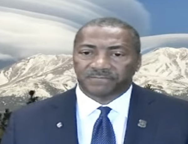
USFS Chief Randy Moore
USFS Chief Randy Moore during Sept. 29, 2021 Congressional hearing.

In a Congressional committee hearing September 29 the new Chief of the U.S. Forest Service hit a lot of the right notes in his testimony. It was before the House of Representatives Agriculture Committee’s Subcommittee on Conservation and Forestry. The hearing was titled, “The 2021 Wildland Fire Year: Responding to and mitigating threats to communities.”

In his prepared statement, Chief Randy Moore, apparently standing in front of a real or virtual photo of Mt. Shasta topped by lenticular clouds, said “America’s forests are in a state of emergency and it’s time to treat them like one.”

He spoke for several minutes about issues related to the status of federal wildland firefighters. Here is an excerpt:

“We must maintain a stable resilient firefighting force. That starts with taking care of our brave men and women who fight fires.

“They deserve better work/life balance and benefits. They deserve a supportive workplace in return for the grueling hard work they do. At a time of increased stress, suicide, and depression they also need counseling and support services to prevent tragedy. They deserve better pay, above all. Federal wages for firefighters have not kept pace with states.

“We must also modernize our wildland fire management system. This includes improving the use of technology. It also includes upgrading our models and systems for decision making and strengthening our cooperative relationships.

“We will never hire enough firefighters, we will never buy enough engines or aircraft to fight these fires. We must actively treat forests. That’s what it takes to turn this situation around. We must shift from small scale treatments to strategic science-based treatments across boundaries. It must start with those places most critically at risk. We must treat 20 million acres over 10 years. Done right in the right places, treatments make a difference.”

Later the committee went on to talk more about firefighter pay, filling positions that are now occupied by detailers, aggressive forest management,  timber harvesting, and other issues.

An interesting but very brief discussion occurred at 1:41:08 (see the video above) when Representative Doug LaMalfa of California’s 1st Congressional District (Oroville) asked the Chief about a report of difficulties in the working relationship between the Forest Service and CAL FIRE that surfaced during the Caldor Fire west of South Lake Tahoe according to 60 Minutes September 26, 2021.

“I think I have different information than you do, Congressman,” the Chief said. “I am not aware of any problems between the Forest Service and CAL FIRE. As I indicated earlier that relationship is really solid. So, I am not aware of anything that might be going on.”

Earlier Representative LaMalfa tried to get the Chief to say the Forest Service is committed to aggressive initial attack on new fires, but the Chief preferred to use the term “aggressive forest management.” (He later said that they already do aggressive initial attack.)

Representative LaMalfa asked about the Tamarack Fire near Markleeville, CA which started as a single tree on July 4, 2021 and was monitored but not suppressed for 13 days while it was very small until it suddenly grew very large. It burned at least 15 structures and more than 67,000 acres as it ran from California into Nevada jumping Highway 395 and prompting the evacuation of 2,000 people.

In the hearing Chief Moore said that after the fire started the Forest Service “spiked out a small crew to monitor” the fire. If that was the case, they apparently took no action, because the USFS reported on July 10 that it was 0.25 acre, they were not going to insert crews due to safety concerns, and it “posed no threat to the public, infrastructure, or resource values.”

In describing the situation, the Chief said that when the Tamarack Fire started on July 4 there were 100 large wildland fires and 27,000 fire personnel had been deployed. “We would have loved to have had enough crews to put on that fire,” the Chief said. “What we should be talking about is a very active forest management program. There will always be situations where you can second guess decisions that were made.”

The national Situation Report from July 5, 2021 shows that there were only 33 large uncontained fires at the time and 7,652 personnel had been mobilized. On July 22 the incident management team working on the Tamarack Fire reported that 1,200 personnel were assigned to the fire.

Characteristics of structures that burned in the 2018 Camp Fire

The blaze in Northern California destroyed 18,804 structures, most of which were in Paradise

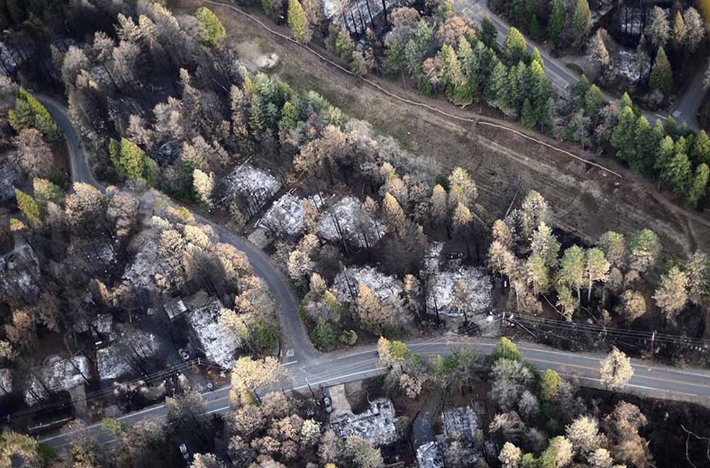
Camp Fire structures
Aerial image showing a portion of Magalia just NW of Paradise, illustrating a gradient of fire damage to overstory vegetation with distance from destroyed homes. At least in some areas, burning homes may have influenced the effects to overstory vegetation more so than burning overstory vegetation influenced the outcome to homes. Photo: Owen Bettis, Deer Creek Resources.

In a paper published October 4, 2021, researchers analyzed the structures that were destroyed and those that survived the Camp Fire that ran through the city of Paradise, California in 2018. They considered at least four primary characteristics of structures:

  • Were they built before or after the adoption in 2008 of Chapter 7A of the California Building Code which requires certain fire resistance measures, including exterior construction materials used for roof coverings, vents, exterior walls, and decks and applies to new construction of residential and commercial buildings in designated fire hazard severity zones.
  • Distance to nearest destroyed structure.
  • Number of structures destroyed within 100 meters.
  • Pre-fire overstory tree canopy within 100 meters

They found that the last three criteria were the strongest predictors of survival. Homes more than 18 meters from a destroyed structure and with less than 53 percent pre-fire overstory canopy within 30 to 100 meters survived at a substantially higher rate than homes in closer proximity to a destroyed structure or in areas with higher pre-fire overstory canopy. Most fire damage to surviving homes appeared to result from radiant heat from nearby burning structures or flame impingement from the ignition of near-home combustible materials. The researchers concluded that building and vegetation modifications are possible that would substantially improve outcomes. Among those include improvements to windows and siding in closest proximity to neighboring structures, treatment of wildland fuels, and eliminating near-home combustibles, especially within 1.5 meters of the structure.

The authors noted that while 7a includes requirements not found in many building codes, a few others are more complete incorporating multiple construction classes based on anticipated radiant heat, flame, and ember exposure levels. For example Chapter 7A does not consider the interaction between components such as siding, window, and the under-eave area on an exterior wall.

There is an opportunity for much needed improvement in both current building codes and how we live in wildfire prone WUI areas.

Below is the complete Conclusion section from the research.


Conclusions

The results of this study support the idea that both proximities to neighboring burning structures and surrounding vegetation influence home survival with wildfire. Denser developments, built to the highest standards, may protect subdivisions against direct flame impingement of a vegetation fire, but density becomes a detriment once buildings ignite and burn.

Recent examples of losses in areas of higher density housing include the wind-driven 2017 Tubbs Fire in northern California, where house-to-house spread resulted in the loss of over 1400 homes in the Coffey Park neighborhood (Keeley and Syphard 2019), and the wind-driven 2020 Almeda Fire in southern Oregon, which destroyed nearly 2800 structures, many in denser areas in the towns of Talent and Phoenix (Cohen and Strohmaier 2020). Once fire becomes an urban conflagration, proximity to nearby burned structures becomes especially important because occupied structures contain significant quantities of fuel, produce substantial heat when burned, and are a source of additional embers. For density to be protective, home and other structure ignitions would need to be rare.

Fifty-six percent of homes in Paradise built during or after 2008 did not survive, illustrating that much improvement is needed in both current building codes and how we live in wildfire prone WUI areas before proximity to nearby structures becomes a benefit rather than a vulnerability. The threat posed by nearby burning structures as well as our finding of an apparent strong influence of vegetation 30–100 m from the home—a distance that in most cases encompasses multiple adjacent properties—demonstrates that neighbors need to work together to improve the overall ability of homes and communities to resist wildfire exposures.

To maximize survivability, homes need to be designed and maintained to minimize the chance of a direct flame contact, resist ember ignition, and survive extended radiant heat exposure. Our analyses demonstrating the strong influence of nearby burning structures on home survival suggests improvements to resist radiant heat exposures may be warranted in the California Building Code—i.e., increasing the standards for buildings within a certain minimum distance of other structures.

Some possible improvements might include noncombustible siding with rating minimums tied to proximity to other structures, both panes in windows consisting of tempered glass, or installation of deployable non-combustible shutter systems. Additionally, certain options for complying with Chapter 7A are better for resisting radiant heat and flame contact exposures and could minimize fire spread to other components. Whereas the International Code Council’s Wildland Urban Interface Building Code (International Code Council 2017) provides three ignition-resistant construction classes to allow for material restrictions as a function of exposure level, Chapter 7A consists of one level, so is binary in nature in that a building either needs to comply, or it does not. The Australian building code for construction in bushfire prone areas, AS 3959 (Standards Australia 2018), incorporates six different construction classes based on anticipated radiant heat, flame, and ember exposure levels. Interaction between components, for example, siding, window, and the under-eave area on an exterior wall, is not considered.

Our summary of damaged but not destroyed homes in Paradise was in line with other reports showing a high proportion of home ignitions indirectly resulting from embers (Mell et al. 2010). Embers frequently ignited near home combustibles such as woody mulch, fences, and receptive vegetative fuels with flames and/or associated radiant heat then impacting the home itself, supporting awareness of the importance of combustibles within the first 1.5 m (5 ft) of the building on home survival.

A re-interpretation of defensible space fuel modifications is needed to increase the building’s resistance and exposure to embers and direct flame contact, especially in the area immediately around a building and under any attached deck or steps. This does not diminish the value of defensible space fuel modifications 9 to 30 m (30 to 100 ft) away from the home, which not only reduces fuel continuity and the probability of direct flame contact to the home, but also provides firefighters a chance to intervene.

While our data show a relationship between home loss and vegetative fuels (high pre-fire overstory canopy cover likely associated with a greater litter and woody fuel abundance, as well as other wildland understory vegetation) that can contribute to fire intensity and ember generation, the WUI fire loss issue has been described as home ignition problem more so than a wildland fire problem (Cohen 2000; Calkin et al. 2014). The damaged home data were in line with this view, with few homes showing evidence of continuity with wildland fuels that would contribute to flame impingement, but numerous homes with near home fuels, both from manmade and natural sources, that led to direct or indirect ember ignitions.

California’s Mediterranean climate will continue to challenge its residents with regular wildfire exposure throughout the state. Whether through modifying the nearby surface and vegetative wildland fuels or the home itself, adapting to wildfire will take time. The good news is that the trend in survival is improving with newer construction practices. However, with 56% of houses built after 2008 still succumbing to the Camp Fire, much room for improvement remains.

Our data suggest it is possible to build (and maintain) buildings that have a high probability of surviving a worst-case scenario type of wildfire, even in fire-prone landscapes such as the Paradise area. Newer homes built after 1972, where the nearest burning structure was >18 m away, and fuels associated with vegetation 30–100 m from the home kept at moderate and lower levels (<53% canopy cover) had a 61% survival rate—an approximately 5-fold improvement over the Paradise housing population as a whole. Survival percentages substantially higher still are potentially possible if all components of risk, including ember generation in nearby wildland fuels, continuity of wildland and other fuels on the property, and home ignitability are sufficiently mitigated.


Citation:

Knapp, E.E., Valachovic, Y.S., Quarles, S.L. et al. Housing arrangement and vegetation factors associated with single-family home survival in the 2018 Camp Fire, California. fire ecol 17, 25 (2021). https://doi.org/10.1186/s42408-021-00117-0