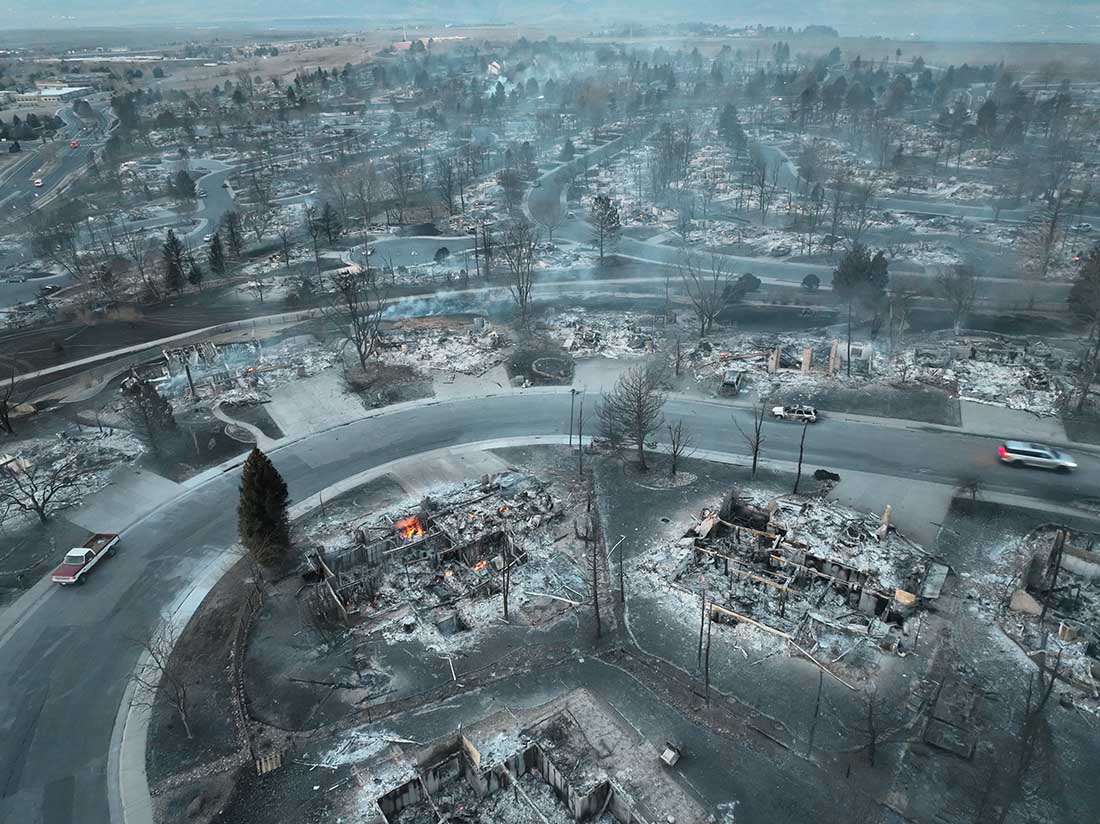
Early Friday morning, about 20 hours after the Marshall Fire ignited, a drone operated by Twitter user WxChasing/Brandon Clement flew over subdivisions that were devastated by the December 30 fire. It found block after block of ash piles, some still smoldering. In many scenes there was scarcely a structure still standing. (Scroll down to see the video.)
All of the reasons why some houses did not burn even though dozens around them were consumed could not be determined from the video, but there was one common feature — the survivors were more distant from the neighboring homes. Many houses in the subdivisions were only 10 to 20 feet apart based on archived imagery in Google Earth.
The fire was driven by very strong winds gusting at 60 to 100 mph, extremely dry conditions after months of drought, and relative humidity in the mid-20s. These are the very worst fire conditions. The weather paired with the nearly back to back structures led to the fire spreading through a continuous human-made fuel bed. When one house burned the convective and radiant heat easily ignited its neighbor, which ignited its neighbor, etc.
The fire in the vegetation and structures lofted burning materials far downwind, creating distant spot fires in the home ignition zone on bone dry lawns, mulch beds around ornamental plants, and on structures. It is unknown at this point how many had been designed and built to be fire resistant, such as the characteristics of the roof, vents, siding, doors, windows, foundation, fences, eaves, and decks. A FEMA publication (13 MB) has excellent detailed recommendations. Headwaters Economics found that the cost of building a fire-resistant home is about the same as a standard home. Local building codes could regulate these features. But if the lot size is so small that residences are only 10 to 20 feet apart, if one becomes fully involved, the neighbors also burn, especially during windy conditions.
So far we have listed some factors that affect the vulnerably of structures during a wildland-urban interface fire: home spacing and lot size, the envelope of the structure itself, fire codes, and the home ignition zone. Others are:
Safety zones where residents can shelter in place;
Road and driveway width, wide enough for large fire trucks;
Turnarounds at the end of roads;
Signage, and;
Emergency water supply.
The video below of the Marshall Fire devastation was shot by WxChasing/Brandon Clement at first light on December 31, 2021, the day after the fire started. Not long after, snow began falling. The National Weather Service in nearby Boulder recorded an accumulation of eight inches.
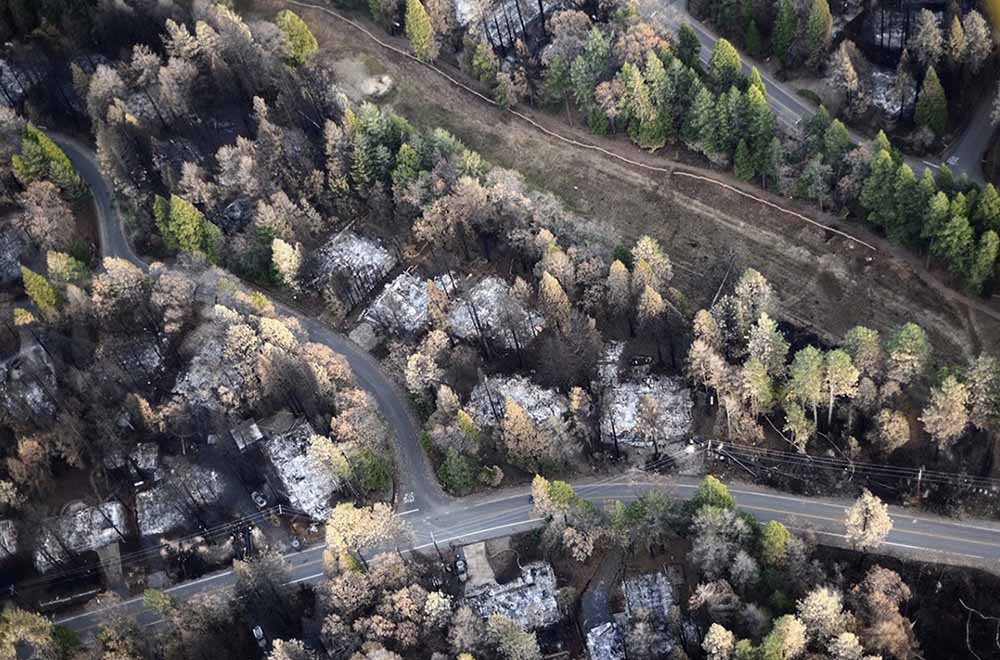
The blaze in Northern California destroyed 18,804 structures, most of which were in Paradise
Aerial image showing a portion of Magalia just NW of Paradise, illustrating a gradient of fire damage to overstory vegetation with distance from destroyed homes. At least in some areas, burning homes may have influenced the effects to overstory vegetation more so than burning overstory vegetation influenced the outcome to homes. Photo: Owen Bettis, Deer Creek Resources.
In a paper published October 4, 2021, researchers analyzed the structures that were destroyed and those that survived the Camp Fire that ran through the city of Paradise, California in 2018. They considered at least four primary characteristics of structures:
Were they built before or after the adoption in 2008 of Chapter 7A of the California Building Code which requires certain fire resistance measures, including exterior construction materials used for roof coverings, vents, exterior walls, and decks and applies to new construction of residential and commercial buildings in designated fire hazard severity zones.
Distance to nearest destroyed structure.
Number of structures destroyed within 100 meters.
Pre-fire overstory tree canopy within 100 meters
They found that the last three criteria were the strongest predictors of survival. Homes more than 18 meters from a destroyed structure and with less than 53 percent pre-fire overstory canopy within 30 to 100 meters survived at a substantially higher rate than homes in closer proximity to a destroyed structure or in areas with higher pre-fire overstory canopy. Most fire damage to surviving homes appeared to result from radiant heat from nearby burning structures or flame impingement from the ignition of near-home combustible materials. The researchers concluded that building and vegetation modifications are possible that would substantially improve outcomes. Among those include improvements to windows and siding in closest proximity to neighboring structures, treatment of wildland fuels, and eliminating near-home combustibles, especially within 1.5 meters of the structure.
The authors noted that while 7a includes requirements not found in many building codes, a few others are more complete incorporating multiple construction classes based on anticipated radiant heat, flame, and ember exposure levels. For example Chapter 7A does not consider the interaction between components such as siding, window, and the under-eave area on an exterior wall.
There is an opportunity for much needed improvement in both current building codes and how we live in wildfire prone WUI areas.
Below is the complete Conclusion section from the research.
Conclusions
The results of this study support the idea that both proximities to neighboring burning structures and surrounding vegetation influence home survival with wildfire. Denser developments, built to the highest standards, may protect subdivisions against direct flame impingement of a vegetation fire, but density becomes a detriment once buildings ignite and burn.
Recent examples of losses in areas of higher density housing include the wind-driven 2017 Tubbs Fire in northern California, where house-to-house spread resulted in the loss of over 1400 homes in the Coffey Park neighborhood (Keeley and Syphard 2019), and the wind-driven 2020 Almeda Fire in southern Oregon, which destroyed nearly 2800 structures, many in denser areas in the towns of Talent and Phoenix (Cohen and Strohmaier 2020). Once fire becomes an urban conflagration, proximity to nearby burned structures becomes especially important because occupied structures contain significant quantities of fuel, produce substantial heat when burned, and are a source of additional embers. For density to be protective, home and other structure ignitions would need to be rare.
Fifty-six percent of homes in Paradise built during or after 2008 did not survive, illustrating that much improvement is needed in both current building codes and how we live in wildfire prone WUI areas before proximity to nearby structures becomes a benefit rather than a vulnerability. The threat posed by nearby burning structures as well as our finding of an apparent strong influence of vegetation 30–100 m from the home—a distance that in most cases encompasses multiple adjacent properties—demonstrates that neighbors need to work together to improve the overall ability of homes and communities to resist wildfire exposures.
To maximize survivability, homes need to be designed and maintained to minimize the chance of a direct flame contact, resist ember ignition, and survive extended radiant heat exposure. Our analyses demonstrating the strong influence of nearby burning structures on home survival suggests improvements to resist radiant heat exposures may be warranted in the California Building Code—i.e., increasing the standards for buildings within a certain minimum distance of other structures.
Some possible improvements might include noncombustible siding with rating minimums tied to proximity to other structures, both panes in windows consisting of tempered glass, or installation of deployable non-combustible shutter systems. Additionally, certain options for complying with Chapter 7A are better for resisting radiant heat and flame contact exposures and could minimize fire spread to other components. Whereas the International Code Council’s Wildland Urban Interface Building Code (International Code Council 2017) provides three ignition-resistant construction classes to allow for material restrictions as a function of exposure level, Chapter 7A consists of one level, so is binary in nature in that a building either needs to comply, or it does not. The Australian building code for construction in bushfire prone areas, AS 3959 (Standards Australia 2018), incorporates six different construction classes based on anticipated radiant heat, flame, and ember exposure levels. Interaction between components, for example, siding, window, and the under-eave area on an exterior wall, is not considered.
Our summary of damaged but not destroyed homes in Paradise was in line with other reports showing a high proportion of home ignitions indirectly resulting from embers (Mell et al. 2010). Embers frequently ignited near home combustibles such as woody mulch, fences, and receptive vegetative fuels with flames and/or associated radiant heat then impacting the home itself, supporting awareness of the importance of combustibles within the first 1.5 m (5 ft) of the building on home survival.
A re-interpretation of defensible space fuel modifications is needed to increase the building’s resistance and exposure to embers and direct flame contact, especially in the area immediately around a building and under any attached deck or steps. This does not diminish the value of defensible space fuel modifications 9 to 30 m (30 to 100 ft) away from the home, which not only reduces fuel continuity and the probability of direct flame contact to the home, but also provides firefighters a chance to intervene.
While our data show a relationship between home loss and vegetative fuels (high pre-fire overstory canopy cover likely associated with a greater litter and woody fuel abundance, as well as other wildland understory vegetation) that can contribute to fire intensity and ember generation, the WUI fire loss issue has been described as home ignition problem more so than a wildland fire problem (Cohen 2000; Calkin et al. 2014). The damaged home data were in line with this view, with few homes showing evidence of continuity with wildland fuels that would contribute to flame impingement, but numerous homes with near home fuels, both from manmade and natural sources, that led to direct or indirect ember ignitions.
California’s Mediterranean climate will continue to challenge its residents with regular wildfire exposure throughout the state. Whether through modifying the nearby surface and vegetative wildland fuels or the home itself, adapting to wildfire will take time. The good news is that the trend in survival is improving with newer construction practices. However, with 56% of houses built after 2008 still succumbing to the Camp Fire, much room for improvement remains.
Our data suggest it is possible to build (and maintain) buildings that have a high probability of surviving a worst-case scenario type of wildfire, even in fire-prone landscapes such as the Paradise area. Newer homes built after 1972, where the nearest burning structure was >18 m away, and fuels associated with vegetation 30–100 m from the home kept at moderate and lower levels (<53% canopy cover) had a 61% survival rate—an approximately 5-fold improvement over the Paradise housing population as a whole. Survival percentages substantially higher still are potentially possible if all components of risk, including ember generation in nearby wildland fuels, continuity of wildland and other fuels on the property, and home ignitability are sufficiently mitigated.
Citation:
Knapp, E.E., Valachovic, Y.S., Quarles, S.L. et al. Housing arrangement and vegetation factors associated with single-family home survival in the 2018 Camp Fire, California. fire ecol 17, 25 (2021). https://doi.org/10.1186/s42408-021-00117-0
It will apply for one year after the Governor declared a state of emergency
Glen Cove Fire south of south of Vallejo, California, northeast of the I-80 Carquinez Bridge, October 27, 2019. Photo by @arrowstewtoe.
The California Department of Insurance is invoking a law passed in 2018 that bans insurance companies from dropping or refusing to renew homeowners policies in zip codes within or adjacent to the perimeters of recent fires. This will apply for one year after the Governor declared a state of emergency in October, 2018 and will affect at least 800,000 homes in wildfire disaster areas in Northern and Southern California. The action by Insurance Commissioner Ricardo Lara is the result of Senate Bill 824 that he authored last year while serving as state senator.
In his announcement about the localized ban, the Commissioner went a step further and called on insurance companies to voluntarily cease all non-renewals related to wildfire risk statewide until December 5, 2020.
Many homeowners in California are finding that the premiums on their policies have doubled or tripled in the last two years, and insurance companies in some cases are canceling or refusing to renew policies on residences in areas where wildfires have occurred. California’s property insurers are beginning to retreat from areas they identify as having higher wildfire risk.
Local governments are concerned that this trend could disrupt local real estate markets and cause property values to decline, reducing tax revenue available for vital services to residents such as fire protection, community fire mitigation, law enforcement, road repairs, and hospitals.
The California Department of Insurance has identified some of the zip codes affected by the temporary ban on dropping or refusing to renew homeowners policies. The following fires with the affected zip codes are listed: Saddleridge, Eagle, Kincade, Tick, Getty, Hill, and Maria.
CAL FIRE has not yet provided the fire perimeter maps for the Water, 46, Hillside, Easy, Sky, and Glen Cove Fires, therefore the zip codes near these fires is not yet available.
Opinion: Could this be a tipping point?
I have wondered for years when the insurance companies were going to drastically raise their rates or refuse to issue policies in wildfire-prone areas. I figured that when it occurred it could be a tipping point that could lead to broad positive actions affecting the resiliency of communities at risk from wildfires. Either that, or those areas could experience significant outward migration of residents, causing economic disruption.
Fire-prone communities, if they are going to survive over the long term, have to learn to live with fire. Sticking their heads in the sand and thinking fires can’t happen to them is not recognizing reality.
Here are the broad areas that need to be considered:
Home spacing and lot size
Envelope of the structure itself
Home ignition zone
Community infrastructure and planning
Wildland-urban interface
The only effective way to ensure that residents understand and implement these five tasks is to make them mandatory by establishing Fire Codes at the local and state levels.
Above: Homes being rebuilt in the Coffey Park area of Santa Rosa. Screenshot from Sacramento Bee video.
In Santa Rosa, California the 1,200 homes that were destroyed in the 2017 Tubbs Fire are being rebuilt without a requirement that they adhere to the stricter building codes required in rural areas of California that would make them more resistant to being consumed in the next wildfire.
…Coffey Park [neighborhood] is rebuilding quickly: The community organization Coffey Strong says more than half of the 1,200 homes that burned down in 2017 are finished, and hundreds more are under construction.
But some wildfire experts wonder if Coffey Park isn’t courting danger by ignoring a state building code designed for wildfire-prone areas.
“They’re setting themselves up for the next disaster,” said Chris Dicus, a wildfire expert at Cal Poly San Luis Obispo. “I was disappointed to see they didn’t build up to code.”
Coffey Park residents seem resigned to the risk of another fire. They consider it part of the cost of living in a neighborhood they love. When asked about building codes, they say yes, another monster like the Tubbs Fire would be devastating — but no amount of fire-resistant roofing would likely change that.
“If it’s going to burn down, it’s going to burn down,” said Charlie Catlett, a retired physician who moved back home a little more than a week ago, after the latest evacuations were over.
Chapter 7A of the California Building Code designed for the state’s areas at high risk from wildfire can be optionally adopted by cities, but is mandatory in rural areas designated by CAL FIRE as being at high risk of wildfires. It lays out standards for roofs, exterior walls, vents in exterior walls and attics, windows, exterior doors, decking, and outbuildings.
Analysts studying the aftermath of the Camp Fire which destroyed much of Paradise, California found that homes built to fire-safe standards had a much higher survival rate than those that were not. Beginning in 2008 new construction in the city was required to follow Chapter 7A. Fifty-one percent of the homes built under that standard survived, while only eighteen percent built before 2008 did.
Headwaters Economics found that the cost of building a fire-resistant home is about the same as a standard home.
Adopting sensible building codes is very important, but a holistic approach is required to keep from repeating wildfire disasters:
Structures that burned in the Puntzi Fire in British Columbia.
A reporter asked me what needs to be done to keep from repeating disasters like we have seen recently in California at Paradise, Redding, and the Napa Valley. I told him that there is no one thing that needs to be done, such as raking or “forest management”, it requires a comprehensive holistic approach.
The principle of the weakest link in the chain applies here. If one of the categories of improvements to protect a development is sub-par, the individual structures and the entire community in a fire-prone environment is at risk. And if a homeowner does not do their part, it can endanger their neighbors.
Reducing the chances that a fire in a populated area will turn into a disaster that burns thousands of homes involves at least six categories of factors: home spacing, envelope of the structure itself, home ignition zone, community infrastructure, wildland urban interface, and fire codes.
Home spacing/lot size
Cities, counties, and planning boards are often under pressure to approve new housing developments. They want to expand their tax base. Developers try to fit as many homes into a new subdivision as possible to maximize their investment. This too often results in homes that are 20-feet apart. If one is ignited by a burning ember that may have traveled a quarter of a mile from a fire (or a burning home) the radiant heat alone can ignite the homes on both sides. Then you can have a self-powered conflagration spreading house to house through a city. When the structures are that close together, the homeowners have not reduced the fuel in the Home Ignition Zone, and the home itself is not built to FireWise standards, a massive disaster can be the result.
If a homeowner wants, or is required, to reduce the flammable material within 100 feet of their residence, what are they expected to do if there is another home 20 feet away that is really a large assembly of flammable material?
A neighborhood on Debbie Lane in Paradise, California, before and after the Camp Fire that started November 8, 2018. The homes were 14 to 18 feet apart.
Some of the homes in Paradise, California that burned were less than 20 feet apart. According to measurements using Google Earth, we determined that the structures in the photo above were 14 to 18 feet from each other.
The National Institute of Standards and Technology released a report on the 2012 Waldo Canyon Fire that burned 344 homes and killed two people in Colorado Springs, Colorado. They concluded that current concepts of defensible space did not account for hazards of burning primary structures, hazards presented by embers, and the hazards outside of the home ignition zone. In addition, NIST recommended:
High-density structure-to-structure spacing in a community should be identified and considered in [Wildland Urban Interface] fire response plans. In the Waldo Canyon fire, the majority of homes destroyed were ignited by fire and embers coming from other nearby residences already on fire. Based on this observation, the researchers concluded that structure spatial arrangements in a community must be a major consideration when planning for WUI fires.
After studying the Carr Fire that destroyed 1,079 residences at Redding, California earlier this year, retired CAL FIRE Battalion Chief Royal Burnett reached similar conclusions.
It was easy to figure out why the houses on the rim burned — they were looking right down the barrel of a blowtorch. Even though they had fire resistant construction, many had loaded their patios with flammable lawn furniture, tiki bars and flammable ornamental plants. Palm trees became flaming pillars, shredded bark became the fuse, junipers became napalm bombs. Under current standards houses are build 6 to an acre; 10 feet to the property line and only 20 feet between houses. Once one house ignited, radiant heat could easily torch the next one.
2. Envelope of the structure itself
Included in this category are characteristics of the roof, vents, siding, doors, windows, foundation, fences, eaves, and decks. A FEMA publication (13 MB) has excellent detailed recommendations. Headwaters Economics found that the cost of building a fire-resistant home is about the same as a standard home. When implemented, Chapter 7A of the California Building Code, regulates these features.
3. Home Ignition Zone
The NFPA and FireWise programs recommend reducing flammable material within 100 feet of structures and spacing the crowns of trees at least 18 feet apart that are within 30 feet of the home, 12 feet apart at 30 to 60 feet, and 6 feet apart at 60 to 100 feet. Another house that is 15 to 50 feet away is also fuel, and if it ignites will be a serious threat.
Road and driveway width, wide enough for large fire trucks
Turnarounds at the end of roads
Signage, and
Emergency water supply.
Again, the FEMA document has great recommendations.
5. Wildland-Urban Interface
There is of course much that can be done surrounding the places where people live that would reduce the vegetation or fuel and decrease the intensity and ember generation potential of a fire as it approaches an urban area. Large scale fuel management projects including fuel breaks and prescribed fire programs are usually conducted by state and federal agencies.
A fuel break does not have to be devoid of vegetation, but it should have minimal tons per acre that would therefore burn with less intensity and with fewer fire brands being lofted downwind. This could enable firefighters to make a stand and create a place from which to ignite a backfire, perhaps aided by aircraft dropping water or retardant.
6. Fire codes are essential
The only effective way to ensure that residents understand and implement these five tasks is to make them mandatory by establishing Fire Codes at the local and state levels.
Analysts studying the aftermath of the Camp Fire which destroyed much of Paradise, California found that homes built to fire-safe standards had a much higher survival rate than those that were not. Beginning in 2008 new construction in the city was required to follow a standard, Chapter 7A of the California Building Code, designed for the state’s areas at high risk from wildfire. Fifty-one percent of the homes built under the 7A code survived, while only eighteen percent built before 2008 did.
Chapter 7A lays out standards for roofs, exterior walls, vents in exterior walls and attics, windows, exterior doors, decking, and outbuildings. Remember, the cost of building a fire-resistant home is about the same as a standard home.
The warming climate is demonstrating that wildfires are becoming increasingly perilous. It is the responsibility of state and local governments protect their citizens by enacting sensible standards.