Three significant new fires in Washington

(UPDATED at 5:34 p.m. PT, July 21, 2015)

Today much of the eastern part of Washington is again under a Red Flag Warning until 8 p.m. for westerly winds of 15 to 25 mph and a relative humidity of 10 to 20 percent.

I-90 Fire between Vantage and George
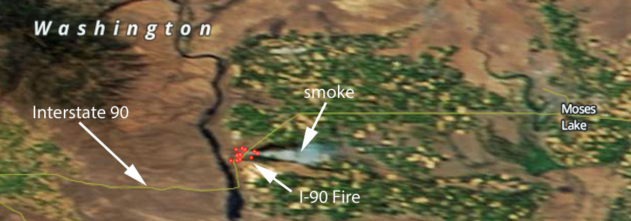
I-90 Fire July 20, 2015
Satellite image showing the location of the I-90 Fire July 20, 2015 (click to enlarge)

We have seen this referred to as the “I-90 Fire” today. It has burned about 900 acres and has a state Type 3 incident management team assigned. Interstate 90 has been subject to intermittent closures and at 7 a.m. on Tuesday was closed.

Blue Creek Fire

UPDATE at 5:34 p.m. PT, July 21, 2015: 

The Blue Creek Fire has grown to 4,000 acres, the Union-Bulletin reports, and has destroyed one residence on Klicker Mountain Road and seven outbuildings near the intersection of Klicker Mountain Road and Blue Creek Road. More areas are threatened including the Bluewood Ski area and the Mill Creek Watershed.

The Union-Bulletin has a gallery of excellent photos of the fire.

****

A helicopter working on the Blue Creek Fire 10 miles east of Walla Walla, Washington, had a mechanical failure while in flight Monday evening, according to the Union-Bulletin which quoted Heather Lee of Walla Walla County Emergency Management. The pilot autorotated the helicopter and walked away from the incident. He refused to be transported to an hospital, Ms. Lee said. Fire Aviation has more information about the helicopter incident.

mapBlue Creek Fire
The red, yellow, and brown squares represent the location of heat detected on the Blue Creek Fire by a satellite at 12:45 p.m. July 21, 2015. The map is looking north, and Walla Walla can be seen on the left side. (click to enlarge)

The fire has grown to 2,500 acres due to extreme fire behavior and long-range spotting. Very little information is being provided by the Washington DNR, but they reported that 32 engines and 3 helicopters are assigned, and eight structures have burned . Evacuations and road closures are in effect.

Colvin Creek Fire, now part of the PC Complex of five fires

A Type 2 incident management team (Leitch/Holloway) is assigned to this complex which has burned 100 acres. Very little information is being provided about this complex of fires.

****

(Originally published at 4:43 p.m. PT, July 20, 2015)

Three new fires have erupted in Washington recently. Much of the state is under a Red Flag Warning on Monday.

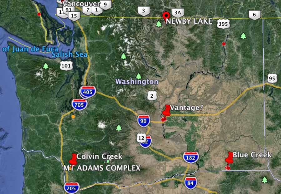
Washington fires, 7-20-2015

Fire between Vantage and George

On Sunday a fire between Vantage and George required the closure of Interstate 90. Later in the day it reopened, but on Monday the fire awakened, or it may be a new ignition in the same area — reports are unclear at this point. But the Interstate is again closed between mileposts 138 and 149 and approximately 50 structures are being evacuated.

KOHO radio reports it has burned 700 to 800 acres.

Blue Creek Fire

The Blue Creek fire is causing evacuations along Blue Creek Road 10 miles east of Walla Walla. Monday afternoon the Blue Mountain Interagency Dispatch Agency Center said it had burned at least one structure and about 350 acres of vegetation. Several air tankers were working the fire Monday afternoon.

You can listen to some of the radio traffic at an online scanner.

Colvin Creek

Monday morning the reported size of the Colvin Creek Fire was 70 acres, and a Type 2 Incident Management Team, WA Team 5 (Leitch/Holloway), was responding. The fire is 11 miles southeast of Kalama.
Vane mount for Kestrel weather meter

Kestrel vane mount
Kestrel Portable Vane Mount. Kestrel photo.

Many wildland fire crews carry some sort of pocketable weather monitoring device, ranging from a sling psychrometer to an electronic weather meter which can cost up to many hundreds of dollars.

After seeing a Tweet by Southeast England Wildfire Group about a wind direction vane mount for a Kestrel weather meter, we checked it out and it’s a real thing. It is designed to be tripod-mountable and can hold any Kestrel weather meter. The idea is that the mount will rotate so that the back of the meter always faces into the wind, enabling accurate wind speed readings. This could be useful if you’re going to be in the same place for a long time, your meter can log the data which you intend to upload onto a computer, or if your meter has Bluetooth capability.

It has received mixed reviews on Amazon, and is priced at $41.18 to $63.06 from various sellers, some without Prime free 2-day shipping. At one point it came with a small tripod (which was criticized by reviewers), but appears now to come without it.

New York Times, on California’s drought and its effect on wildfires

NY Time fire article
NY Times article article about California’s drought and the effect on wildfires. (click to enlarge)

The New York Times has a visually stunning article about the drought in California and its effect on wildfires. It was published about four days before record-setting rain in the south part of the state caused flooding and a bridge washout on a heavily-travelled Interstate Highway. This one rain event, however, will not turn around the drought, or have any lasting effect on the trees and brush that have already died due to lack of water.

The article was written by Haeyoun Park, Damien Cave, and Wilson Andrews. The photos are by Zackary Canepari. If you enjoy seeing awesome photos, especially of wildfires, check it out — preferably on a computer with a large monitor.

Thanks and a tip of the hat go out to Roy.

Five more 20-person crews from the U.S. sent to assist Canadian firefighters

Five additional federal wildland fire suppression crews traveled to Alberta, Canada this past weekend to further assist the province with fire suppression operations. Previously, five federal fire crews, as well as thirty fireline management personnel, traveled to the Canadian provinces of Alberta and Saskatchewan the weekend before.

The 20-person crews were mobilized through the National Interagency Coordination Center in Boise, Idaho under a federal agreement with Canada. They came from the states of Colorado, Idaho, South Dakota, and Utah. In addition to personnel, the National Interagency Coordination Center has sent 300 radios to support operations in British Columbia. The air tanker that was sent to Alberta on July 5 returned to the United States last week.

The states of Michigan, Minnesota, South Dakota, and Wisconsin, through interstate forest fire compacts, are also providing wildland firefighting personnel to support the provinces of Manitoba and Saskatchewan.

Canada is experiencing an busier than normal fire season; fires in the four provinces receiving assistance have burned more than six million acres this year. For more information on Canada’s current fire situation, visit www.ciffc.ca.

Red Flag Warnings, July 20, 2015

wildfireRed Flag Warnings July 20, 2015

While record-setting rain pauses the wildfire season in southern California, parts of Washington, Oregon, and northern California are under Red Flag Warnings and Fire Weather Watches today.

The map was current as of 9:38 a.m. MDT on Monday. Red Flag Warnings can change throughout the day as the National Weather Service offices around the country update and revise their forecasts and maps. For the most current data visit this NWS site or this NWS site.

Record rainfall pauses fire season in southern California

Precipitation last 24 hrs SoCal
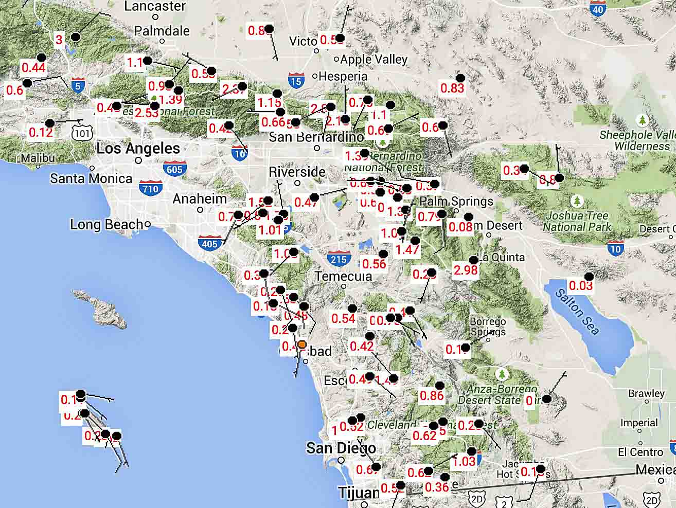
Precipitation for the 24-hour period ending at 8 a.m. PT, July 20, 2015 in southern California. (Click to enlarge.)

The remnants of Hurricane Dolores passed over southern California Sunday setting precipitation records across the area, putting a sudden pause on the wildfire season. All-time rainfall records were set in Los Angeles, San Diego and more than a dozen other cities.

A bridge on Interstate 10 between Palm Springs and the Arizona border washed out and nearby highways that could have served as detours were closed.

Bridge washed out on I-10
A truck sits precariously at a bridge washout on Interstate 10 east of Palm Springs. The driver had moderate injuries. Photo from CAL FIRE/Riverside County Fire Department.

Here are some of the highest precipitation amounts at weather stations in and near National Forests for the 24-hour period that ended at 8 a.m. PT, July 20, 2015:

  • Warm Springs near Castaic, 3.0″
  • Pinyon, San Jacinto Mountains, 2.9″
  • Cameron, east of San Diego, 1.03″
  • Rock Camp, near Lake Arrowhead, 2.8″
  • Mormon Rock, near the recent North Fire, 1.15″

Below is an excerpt from an article at The Weather Channel:

…San Diego broke its all-time July rainfall record Saturday when 1.03 inches fell. That broke not only the July single-day record of 0.83 inches set July 25, 1902, but also the record for an entire July’s rainfall, which was 0.92 inches July 1-31, 1902.

It’s also more rain than San Diego saw in all of January this year; on average, January is the second-wettest month and July the second-driest, with January averaging 66 times more rainfall than July. The only other time July has out-dampened January in San Diego was 1976, when July had 0.02 inch to January’s trace.

San Diego added to its total Sunday with another 0.66 inch of rain as of 11 p.m. The month-to-date total of 1.70 inches, which fell in less than 36 hours, is more rainfall than San Diego had seen in the previous 101 Julys combined; a total of 1.68 inches fell during July from 1914 through 2014 in San Diego.

Los Angeles has also broken its July rainfall records. Downtown Los Angeles picked up 0.36 inch Saturday, which broke the July full-month record of 0.24 inch from July 1-31, 1886. Los Angeles International Airport saw 0.32 inch of rain, tying the record for all of July set in 1992.