Over 3,500 rental cars burned at Southwest Florida International Airport at Fort Myers, Florida April 3, 2020. Photo by Charlotte County Sheriff’s Office.
Yesterday a fire at the Southwest Florida International Airport at Fort Myers, Florida destroyed 3,516 rental cars that were stored in an overflow parking area on the east side of Terminal Access Road. Firefighters on the ground were assisted by helicopters dropping water on the flames. The cars were stored in a grassy field, a fact that may have helped the fire spread. Vicki Moreland, communications director for the airport, said even though 3,516 cars burned, another 3,800 cars in the lot were saved. She said the cause of the fire is being investigated by the State Fire Marshal.
Over 3,500 rental cars burned at Southwest Florida International Airport at Fort Myers, Florida April 3, 2020. Photo by Florida Forest Service – Caloosahatchee Forestry Center.
The main road leading to the terminal was closed during the fire but reopened at 11 p.m. Friday. Saturday morning, Florida Forest Service personnel returned to the scene to make sure the fire did not pick back up again, according to Melinda Avni, FFS mitigation specialist.
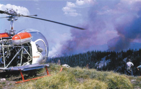
The Charlotte County Sheriff’s Office reported that one of their Huey helicopters flown by Chief Pilot Shane Engelauf made over 80 water drops on the fire.
Over 3,500 rental cars burned at Southwest Florida International Airport at Fort Myers, Florida April 3, 2020. Photo by Charlotte County Sheriff’s Office.A small pyrocumulus cloud forms over the convection column of smoke as over 3,500 rental cars burned at Southwest Florida International Airport at Fort Myers, Florida. Photo by Sean Tully, April 3, 2020.
Twelve years after 13 smokejumpers were killed on the Mann Gulch Fire 13 miles north-northwest of Helena, Montana, 20 jumpers were entrapped on a fire in northern Idaho 83 miles southwest of Missoula, Montana.
It happened August 4, 1961 on the Higgins Ridge Fire in the Nez Perce National Forest after an eight-man crew from Grangeville, Idaho had jumped in the area, followed by 12 men from the Missoula jumper base, the last arriving at 1 p.m. The fire behavior on the two-acre fire was fairly benign until a passing cold front brought a sudden increase in the wind at 4:15 p.m. which resulted in the fire spreading rapidly. The 20 men took refuge in a previously burned area. As the wind increased to 50 mph the supervisors of the two squads, Dave Perry and Fred “Fritz” Wolfrum, instructed the firefighters to remain calm and to clear an area for themselves in the ashes.
Lightning was bursting from the pyrocumulus cloud over the fire as the men in their newly issued orange fire shirts covered their heads with their arms when the fire burned around them. They helped each other swat out the flames on their clothes during the ember shower.
They did not hear it because of the roar of the fire, but they looked up and saw the red skids of a helicopter. It was a Bell 47B-3 that had seating for three people abreast, with the pilot in the middle.
Below is an excerpt from the April, 1994 edition of “The Static Line” published by the National Smokejumper Association:
…The pilot was Rod Snider of the Johnson Flying Service and he had spotted the men and their orange [fire shirts].
Fritz and Snider quickly organized an evacuation plan. Snider had to drop down vertically and take off the same way because of old snags surrounding the jumpers [a maneuver that requires more power than departing from a ridge]. On the first few trips Rod took out two jumpers on each run, having them ride in the cabin. Then, with the helicopter getting hotter, Rod told them he would take four out on each trip. Two rode in the cabin and two hung on to the [cargo trays]. Rod was able to ferry all 20 jumpers to the Freeman Ridge fire camp. Fritz and Tom were among those on the last trip out.
Some of the jumpers were treated at St. Patricks’s Hospital for smoke-burned eyes. Within several days most of the jumpers who had been on the Higgins Ridge Fire were out jumping on more fires.
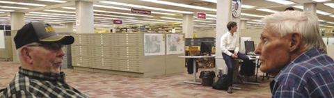
L to R: Helicopter pilot Rod Snider with James Van Vleck. Photo by the National Museum of Forest Service History, June, 2019.
In June, 2019 a reunion was held in Missoula for the firefighters that were involved in the Higgins Ridge Fire. Eleven of the jumpers gave oral interviews and participated in a panel discussion at the National Museum of Forest Service History (video of the panel). Mr. Snider made the trip and gave his oral history, but unfortunately had to return home the night before the panel discussion due to a family emergency.
Below are excerpts from an article in The Missoulian, August 2, 2019:
“It was hard to find them,” said Snider, 89, a quiet man who received awards for his heroism but shuns the obvious mantle of hero.
“The wind was really cooking in there and you couldn’t see the heliport all the time to get down. I had to come in high and drop down into it when I could see a little break,” Snider said in an oral history interview before he left town.
What made you risk your life to do it? an interviewer in Missoula asked.
“Oh, it had to be done. It had to be done,” Snider replied. “I don’t know. You just can’t leave guys down in the position that they were in.”
His helicopter, a Bell 47G-3 that Snider christened “Red Legs” for its painted landing skids and support legs, was one of the first with a supercharger. But the overload was nonetheless hard on it, he said.
“I felt a little uneasy, because I knew I’d over-boosted everything, But when they gave an inspection later on they couldn’t find anything wrong with it,” Snider said.
The following year Snider received the Pilot of the Year Award from the Helicopter Association of America in Dallas and the Carnegie Medal for Heroism.
In 1976, the nation’s bicentennial year, Tom Kovalicky, 84, of Grangeville and Stanley, Idaho, successfully nominated Snider for the North American Forest Fire Medal, which was being revived for the first time since 1956. Snider and his wife were flown to New Orleans for the presentation that October. And in 2002 he was inducted into the Museum of Mountain Flying Hall of Fame.
An article about the fire dated February 21, 2003 at the National Smokejumper Association’s website was written by a firefighter who was on the Higgins Ridge Fire a year before he became a smokejumper.
Higgins Ridge Fire
by Gary Shaw
The year was 1961 when cumulus clouds built up every afternoon promising rain, but delivering isolated dry lightning storms. This was the year before I became a smokejumper. It was my second year to work on the Moose Creek District of the Nezperce National Forest. The preceding summer I had spent as a lookout fireman on top of Bailey Mountain. This year I had been working trail crew for a couple of months until the sky erupted at the end of July and left fires all over the district.
My trail partner (Ron) and I had been cutting a trail from the Selway River to Big Rock Mountain and were currently holed up in a cabin there when a helicopter picked us up to transport us to a small fire on Higgins Ridge. We were to meet a crew walking in from Elbow Bend on East Moose Creek. We saw smokejumpers parachute into the fire area on our way to the fire. We landed on the uphill side of the fire, grabbed our shovels and pulaskis and started for the fire. We could see the jumpers’ orange shirts through the smoke.
Before we could get to the fire a large cumulous cloud covered the sun and the wind picked up to 25 or 30 m.p.h. The fire blew up in our faces, and we were forced to retreat back into a large rockslide.
The jumpers weren’t so lucky. They were trapped in the middle of it with no escape route. They dug in, buried their faces in wet bandanas in the dirt, and tried to find air to breath as the fire roared from a manageable 2 acres to a 1280 acre holocaust. It was late evening, and the fire was beautiful to watch. It was crowning, and trees several hundred feet ahead of the fire would begin to tremble and then burst into flame like a fireworks display.
The fire was so hot that canteens of water near the jumpers started exploding. When things looked at their bleakest, the cavalry arrived in the form of Rod Snider(NCSB-51) in a Bell 47G-3B helicopter from Johnson’s Flying Service in Missoula. It was getting dark when he flew into the middle of the fire and started bringing Jumpers out four at a time, which is two more than the maximum the copter was supposed to carry. He had two guys on the seat and two more on the runners. He made five trips into the fire and rescued twenty jumpers. The manifold pressure on the copter engine was 200% above maximum, and when the engine was torn down later, two pistons fell apart. I heard that “Crash” received 20 cases of beer the next week.
My trail partner and I stayed on the fire through mop-up. The other crew arrived without tools, which were to be dropped in by air. Unfortunately, communications left something to be desired. We kept requesting tools and instead received three separate drops of sleeping bags. Each person had a half dozen sleeping bags, but Ron and I were the only ones who had a shovel and pulaski to work on the fire. So we did.
When the tools finally arrived and we got the fire under control, I walked down to the area where the jumpers had been trapped. I found exploded water cans, unexploded gasoline cans (go figure), and a personal gear bag with all their cameras melted together. I could see Minolta, Canon, and Nikon logos on the fused metal and glass. I sent the lot back to Missoula. The fire had been so hot that there were no snags, just pointed stumps and ashes over a foot deep.
I remember two of the rescued jumpers departed the chopper and immediately asked for a cigarette. Now that’s a habit!
I’ve always wondered what that fire looked like from the other side. If anyone reads this that remembers, let me know.
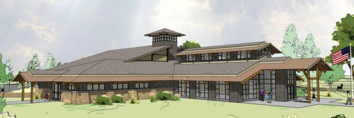
The group that organized the oral history and panel about the Higgins Ridge Fire was organized by the National Museum of Forest Service History. Wildfire Today first wrote about the museum in 2009 five years after they began their effort to raise $10.6 million to build a national museum to commemorate the 100+ year history of the U. S. Forest Service. Their vision began in 1994 when they obtained 36 acres west of the Missoula airport where they hope to build a 30,000 square-foot building.
An architect’s concept of the future National Museum of Forest Service History.
The museum’s fund drive received a significant boost this month when it received a $2 million contribution from the estate of Bill Cannon, a Forest Service retiree.
From the Ravalli Republic:
…Cannon spent most of his Forest Service years in California and Oregon, with an interlude in Hawaii where he was assigned to state and private forestry work. He finished his career in Washington, D.C., where he worked on program planning for the Forest Service’s state and private programs.
Meanwhile, according to a press release announcing his gift, he used his avocation of studying financial markets to become an adept investor.
Cannon became impressed with the National Museum of Forest Service History on a field trip to the site while in Missoula for the 2000 U.S. Forest Service retiree reunion.
Thanks and a tip of the hat go out to Kelly. Typos or errors, report them HERE.
The fire was approximately 18 miles southwest of Medicine Lodge
Tanker 95 makes a drop on the EWB fire in Barber County, Kansas March 25, 2020. From the Kansas Forest Service Facebook page.
Firefighters from 11 agencies battled a wildfire in southern Kansas on March 25 assisted by two UH-60 National Guard Blackhawk helicopters and a privately owned S-2 air tanker.
Kansas Governor Laura Kelly issued a disaster declaration for the EWB Fire burning in Barber County just north of the Oklahoma border about 18 miles southwest of Medicine Lodge.
“The declaration authorizes the use of state resources and personnel to assist with response and recovery operations in affected counties that meet certain criteria,” the governor’s office explained.
Wildfire Today’s very unofficial estimate of the size of the fire based on satellite detections of heat puts it at approximately 4,000 acres. By the end of the day firefighters had mostly stopped the spread of the fire.
Below is an excerpt from the Kansas Forest Service Facebook page, posted March 26, 2020.
Yesterday afternoon, Air Tanker 95, piloted by Bill Garrison, under contract with the Kansas Forest Service was assigned to the EWB Fire in Barber County. Air Tanker 95 made five drops on the EWB Fire with the support of KFS DFMO Bryce Haverkamp who tied in with the local incident commander. This fire brought back memories for many involved as it followed the burn scar from the Anderson Creek Fire of 2016. The collaborative efforts of many agencies and firefighters across the area prevented a wildfire from becoming what could have been a catastrophic wildfire. With social distancing, it may be a while before you are able to thank your local firefighters for their hard work on stopping the EWB Fire – so be sure to send them a text, give them a call, direct message on social media, or air five to thank them for everything they do to protect our Kansas communities.
Map showing heat on the EWB fire detected by a satellite at 2:55 p.m. CDT March 25, 2020. Wildfire Today.
Thanks and a tip of the hat go out to Matt. Typos or errors, report them HERE.
Three fires occurred March 17 along SW Platte River Road near Foxton in Jefferson County, Colorado. Jefferson County Sheriff photo.
Three fires that started Tuesday afternoon caused evacuations on SW Platte River Road near Foxton in Jefferson County, Colorado about 20 miles southwest of Denver.
At least 50 acres burned, but evacuations were lifted by 7:13 p.m. MDT except for River Road and Resort Creek Road.
The cause of the fires is under investigation.
Three fires occurred March 17 along SW Platte River Road near Foxton in Jefferson County, Colorado. Screenshot from CBS4 video in Denver.
Thanks and a tip of the hat go out to Bean. Typos or errors, report them HERE.
A fire in the panhandle has burned over 29,000 ares
Map of the 412 Fire in Beaver County, Oklahoma. Data from 1:30 p.m. CDT March 8, 2020, by Oklahoma Forestry Services. The map shows a small fire northwest of the larger 412 Fire which is the Beaver Road Fire that occurred Sunday, March 1, 2020.
(UPDATED at 8:01 p.m. CDT March 8, 2020)
After more accurate mapping the Oklahoma Forestry Services reported Sunday afternoon that the Beaver Fire in Beaver County has burned 29,120 acres and is 50 percent contained. Crews continue to improve fireline and mopup hot spots.
On Saturday Cody Rehder of the Oklahoma Highway Patrol wrote on Twitter, “The town of Beaver is being evacuated at this time. The fire has reached the SW edge of town. Structures are on fire and the HS football field as burned.”
Photos from the 412 Fire in Beaver County, OK. Photos by Cody Rehder of the OK Highway Patrol, March 7, 2020.
(UPDATED at 12:55 p.m.CST March 8, 2020)
The Beaver fire in the panhandle of Oklahoma is still estimated to be 13,000 acres, but that could change after more accurate mapping is complete. Saturday the Oklahoma Forestry Services responded to 30 new wildfires.
In a Sunday morning update the OFS said, “OFS are over the fire in an [Oklahoma Highway Patrol] aircraft mapping the fire and coordinating with ground resources. Rain chances do enter the southwestern part of the state this afternoon and gradually move east through the state, but going fires from yesterday will remain active.”
A new fire Sunday morning, the Crow Fire, in Latimer Co. near Panola Mtn. OFS photo.
(Originally published at 9:37 p.m. CST March 7, 2020)
The 412 Fire in the Oklahoma panhandle has destroyed structures and burned approximately 13,000 acres, the Oklahoma Forestry Services (OFS) announced in an update at about 8 p.m. CST Saturday. At about 7:30 p.m. Saturday the OFS said fire had been at least temporarily stopped at the EW 100 road three miles north of Beaver.
The communities of Beaver and Forgan are under evacuation orders. Firefighters from Oklahoma, Texas, and Kansas are battling the fire along with Air Tanker 95, a privately owned S-2 aircraft formerly operated by the California Department of Forestry and Fire Protection. The air tanker is under a call when needed arrangement in Kansas, operated by Ag Air Service out of Nikerson, Kansas. The aircraft can carry up to 800 gallons and still has the radial engines, unlike the S-2s operated by CAL FIRE today that have been converted to turbine engines.
Air Tanker 95. Photo by Kansas Forest Service.
There are no details available as to the number of structures that have been destroyed or the locations. Damage assessments are underway.
Red Flag Warnings in northwest Oklahoma, March 7, 2020.
The area was under a Red Flag Warning on Saturday. Strong winds pushed the fire approximately 14 miles across plains.
The 412 Fire occurs one day after the three-year anniversary of the huge Starbuck Fire that burned half a million acres across Oklahoma and Kansas. State and county officials estimated the fire caused at least $50 million in damages.
The 412 Fire near Beaver was one of 19 wildfires the OFS responded to across the state Saturday.
Satellite image showing heat detected on the 412 Fire in the Oklahoma panhandle at 5 p.m. DST March 7, 2020. GOES-17 NASA image.412 Fire, March 7, 2020. Photo by Oklahoma Forestry Services.
Thanks and a tip of the hat go out to Matt. Typos or errors, report them HERE.
Satellite photo showing the vegetation fire on Kaho‘olawe Island February 25, 2020. Sentinel 2, processed by Wildfire Today.
The fire that started over the weekend has burned about 6,400 acres on Kahoʻolawe island southwest of Maui in Hawaii. The Maui Fire Department sized up the blaze Wednesday and confirmed that due to unexploded ordnances left over from 49 years of the military using the island as a bombing range it is unsafe for firefighters on the ground or the air to attempt to suppress the fire.
Storage facilities for the Kaho‘olawe Island Reserve Commission burned in the fire. Photo Feb., 25, 2020 by Kaho‘olawe Island Reserve Commission
The Kaho‘olawe Island Reserve Commission’s main storage facilities have burned.
“Losing the KIRC storage facility, more commonly known as ‘Squid’, to the fire yesterday was a huge setback,” the Commission reported February 26 in a news release. “Squid was home to the majority of our restoration and irrigation supplies and equipment, along with five 2500 gallon water catchment tanks, a fleet of all-terrain vehicles used to transport volunteers and gear to work sites, and water craft used for ocean management projects and activities. All of these things are vital to the restoration efforts undertaken by KIRC staff and their volunteer force.”
The fire has blackened an area on the west side of the island that is about three miles by three miles, covering about 20 percent of the 10-mile long island.
Kaho‘olawe Island fire. Photo by Maui Fire Department.Map, 3-D, showing the location of the fire on Kaho‘olawe Island February 25, 2020. Google/Wildfire Today.