Firefighters gain more containment on Electra Fire

Four miles southeast of Jackson, California

Updated 9:59 a.m. PDT July 7, 2022

Electra Fire map 11:15 p.m. July 6, 2022
The red line on the map was the perimeter of the Electra Fire at 11:15 p.m. July 6, 2022. The green line was the perimeter about 24 hours before. Most of the fire is within the footprint of the 2015 Butte Fire (white line).

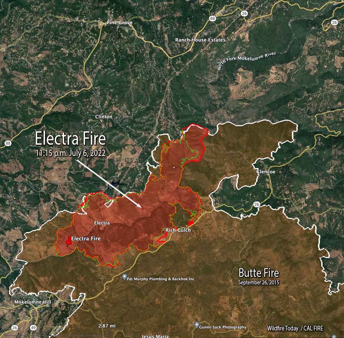
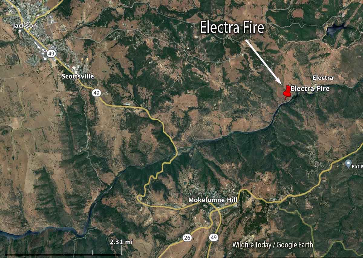
Most of the 372-acre growth of the Electra Fire Wednesday was on the northeast side east of Clinton Bar Road, where crews conducted a firing operation. There was also growth on the southeast side in the Rich Gulch area near Highway 26.

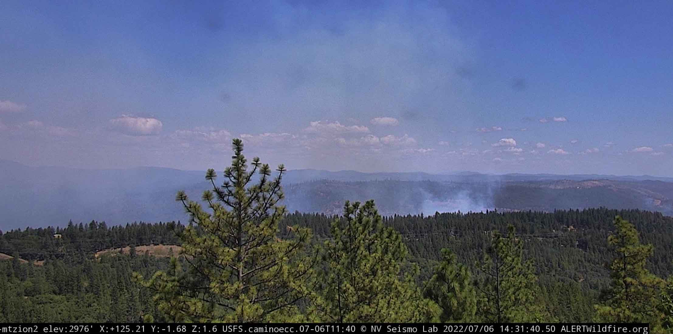
Fire behavior moderated Wednesday night due to increased humidity. Several small spot fires were detected and mitigated with the support of intel platforms and one of the first uses of a CAL FIRE helicopter (C-101) conducting night-flying operations dropping water, using one of the new Firehawk ships.

The wind has been moderate since the Electra Fire started July 4. The prediction for Thursday is 6 to 10 mph winds out of the southwest in the afternoon, 86 degrees, and about 30 percent relative humidity.


Updated at 3:01 p.m. PDT July 6, 2022

Electra Fire map, northeast side, 1:39 p.m. MDT July 6, 2022
Electra Fire map, northeast side. The red squares represent heat detected by satellites at 1:39 p.m. PDT July 6, 2022. The red line was the perimeter at 11:50 p.m. MDT July 5, 2022.

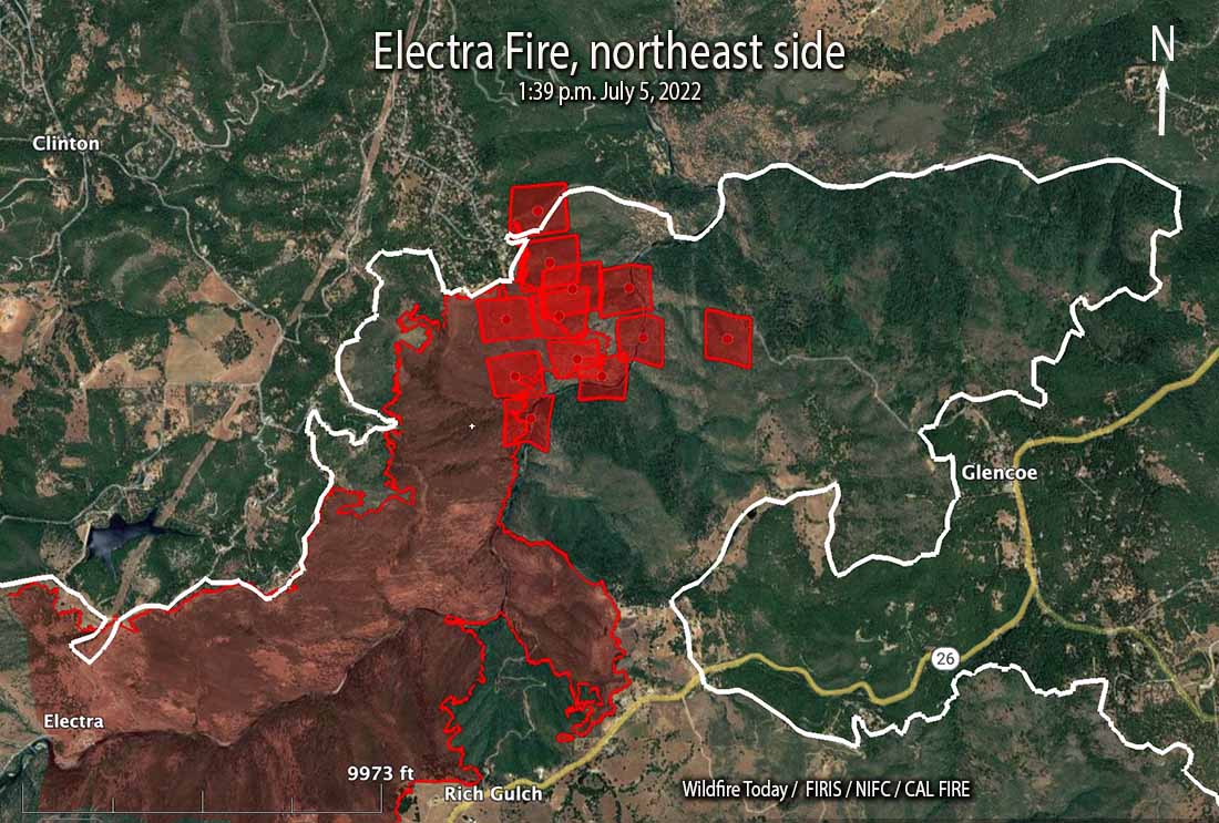
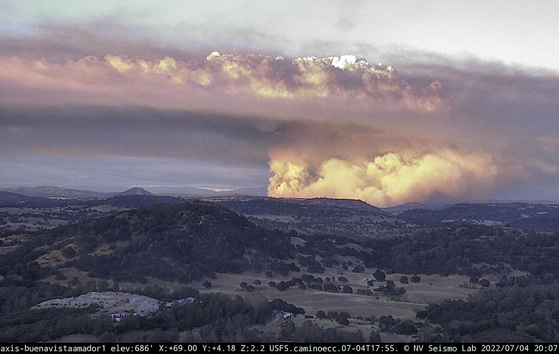
The Electra fire 4 miles southeast of Jackson, California was not as active in the early portion of Wednesday afternoon as it was the previous two days. A satellite overflight at 1:39 p.m. only detected large heat sources on the northeast side southeast of Clinton Bar Road. There is no doubt there were many small heat sources scattered around the fire which could not be seen by the sensors on the satellite, but if it was vigorously spreading those areas would have shown up in the data.

Electra Fire, northeast side
Electra Fire, northeast side, looking southeast from Mt. Zion at 2:31 p.m. MDT July 6, 2022.

Wednesday afternoon at 2 p.m. CAL FIRE announced changes regarding road closures and evacuation status.

AMADOR COUNTY

Evacuation Order Update: The Amador County Sheriff’s Office is removing the road closure at the intersection of Lower Clinton Road and Butte Mountain Road. The new road closure will be moved to the Upper Clinton Road and Butte Mountain intersection. All residents along Clinton Road and Butte Mountain Road within this area are clear to return home. The evacuation order for this area has been reduced to a warning. Visit www.bit.ly/AmadorCountyEvacMap for more information.

Evacuation Warning Update: The warning zone running east from Jackson, along Hwy 88 to Previtali Road has been removed. All existing Evacuation Orders and Warnings not listed above remain in effect.

Road Closures: Tabeaud Road southbound at Highway 88, Mount Zion Road southbound at Highway 88, Upper Clinton Road at Butte Mountain Road, Clinton Road at West Clinton Road, and Electra Road at Highway 49

CALAVERAS COUNTY

All evacuation orders, evacuation warnings, and road closures remain unchanged.
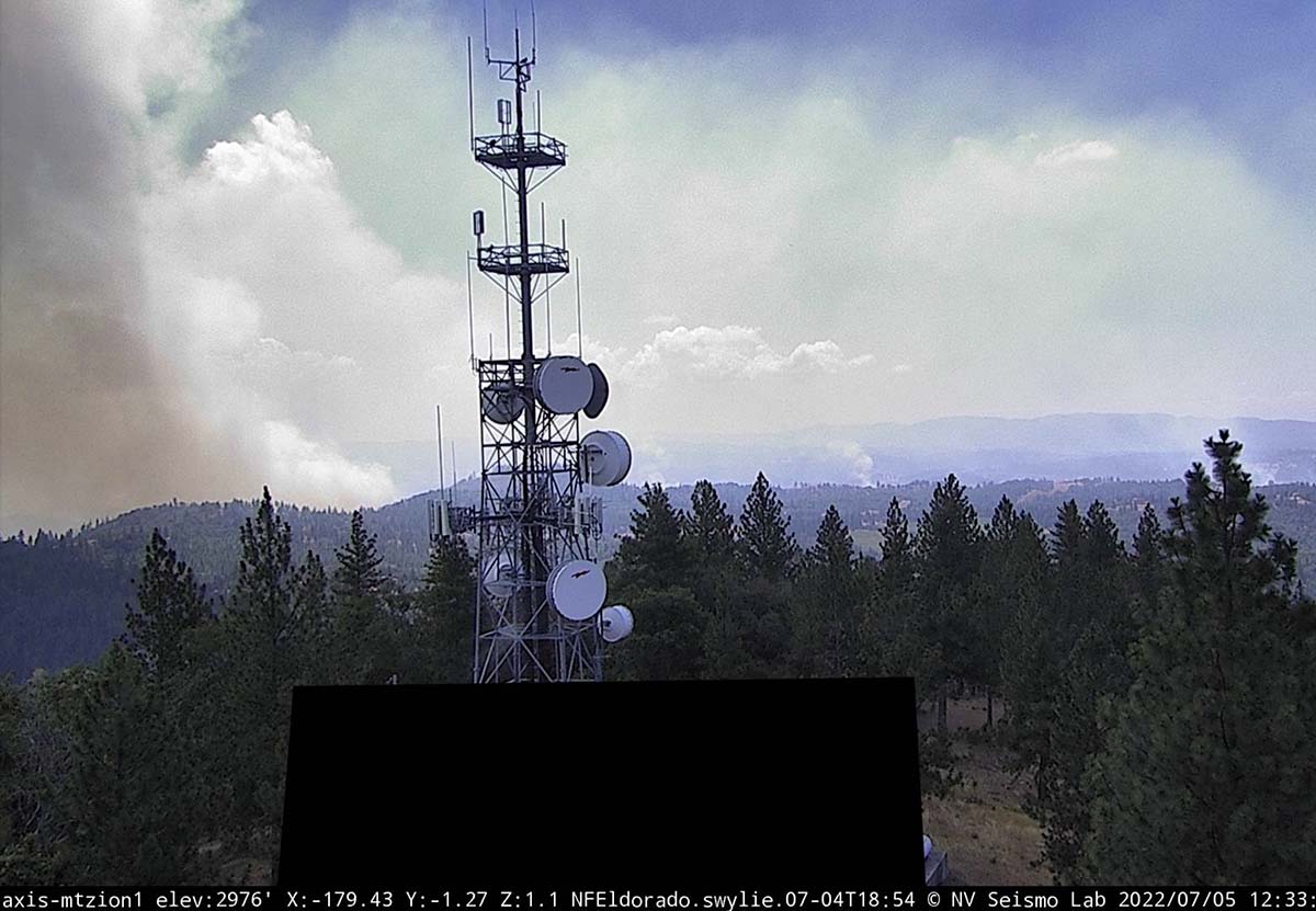

9:37 a.m. PDT July 6, 2022

Electra Fire 3-D map 1150 p.m. MDT July 5, 2022
3-D map of the Electra Fire map at 11:50 p.m. MDT July 5, 2022. Looking northeast.

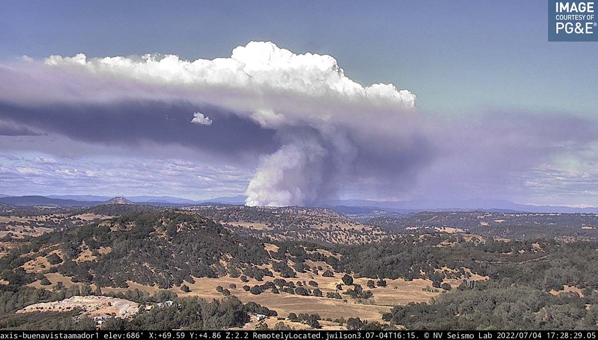
On Tuesday the Electra Fire four miles southeast of Jackson, California was not as active as it was on Monday, which allowed firefighters to make progress aided by numerous drops by air tankers and helicopters. Crews have been constructing direct fireline and burning out where possible, gaining containment, even though the official containment percentages are very low.

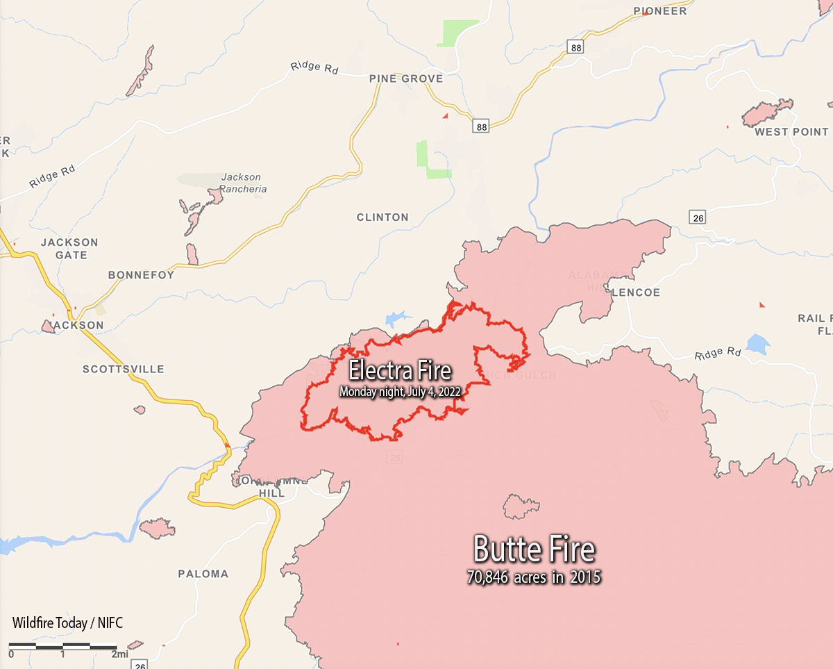
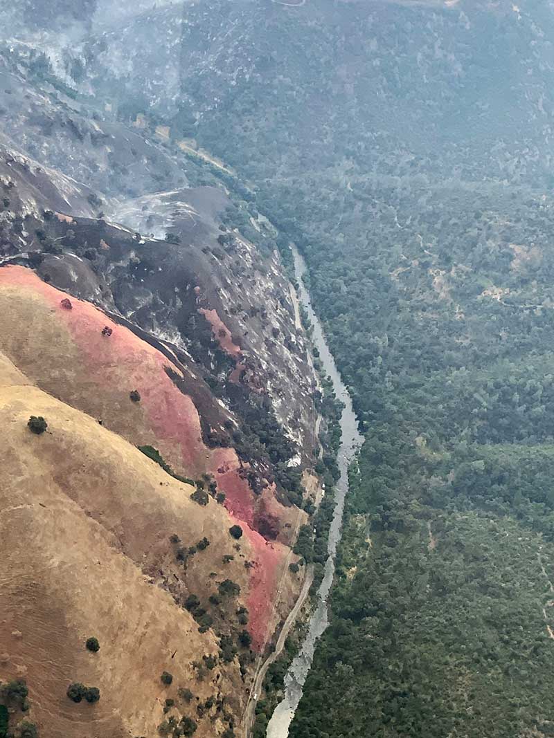
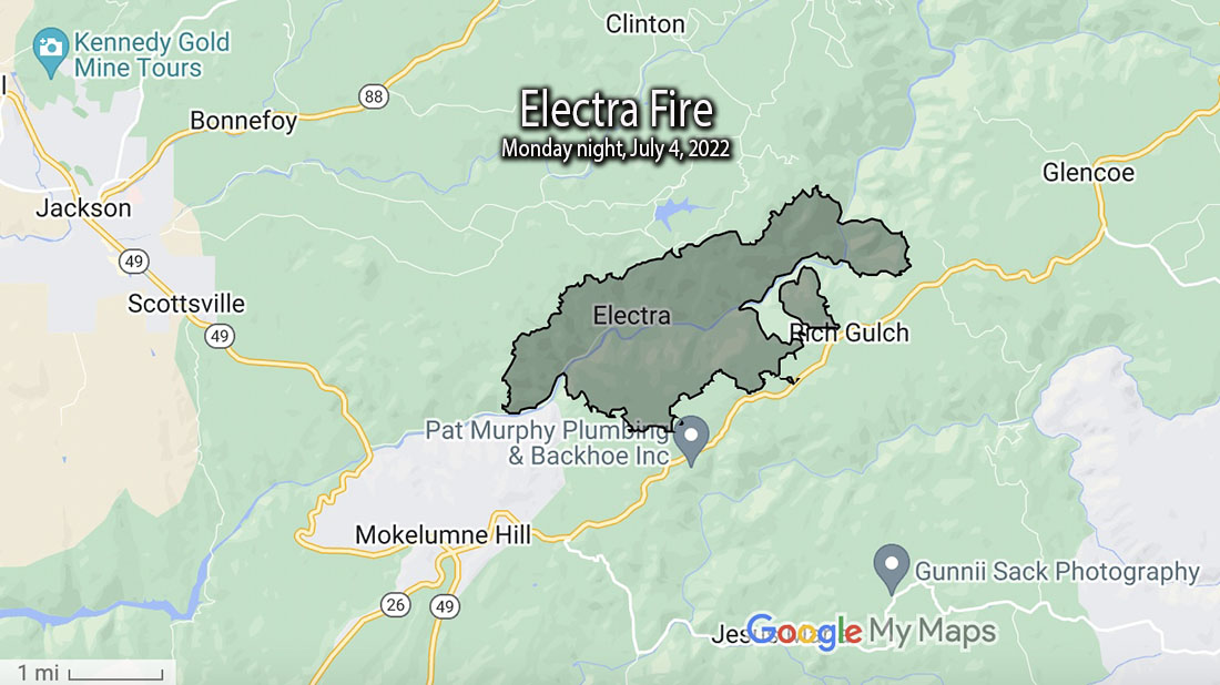
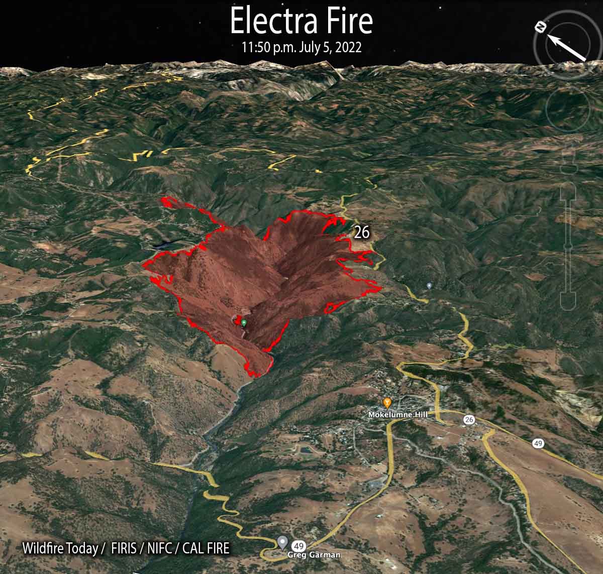
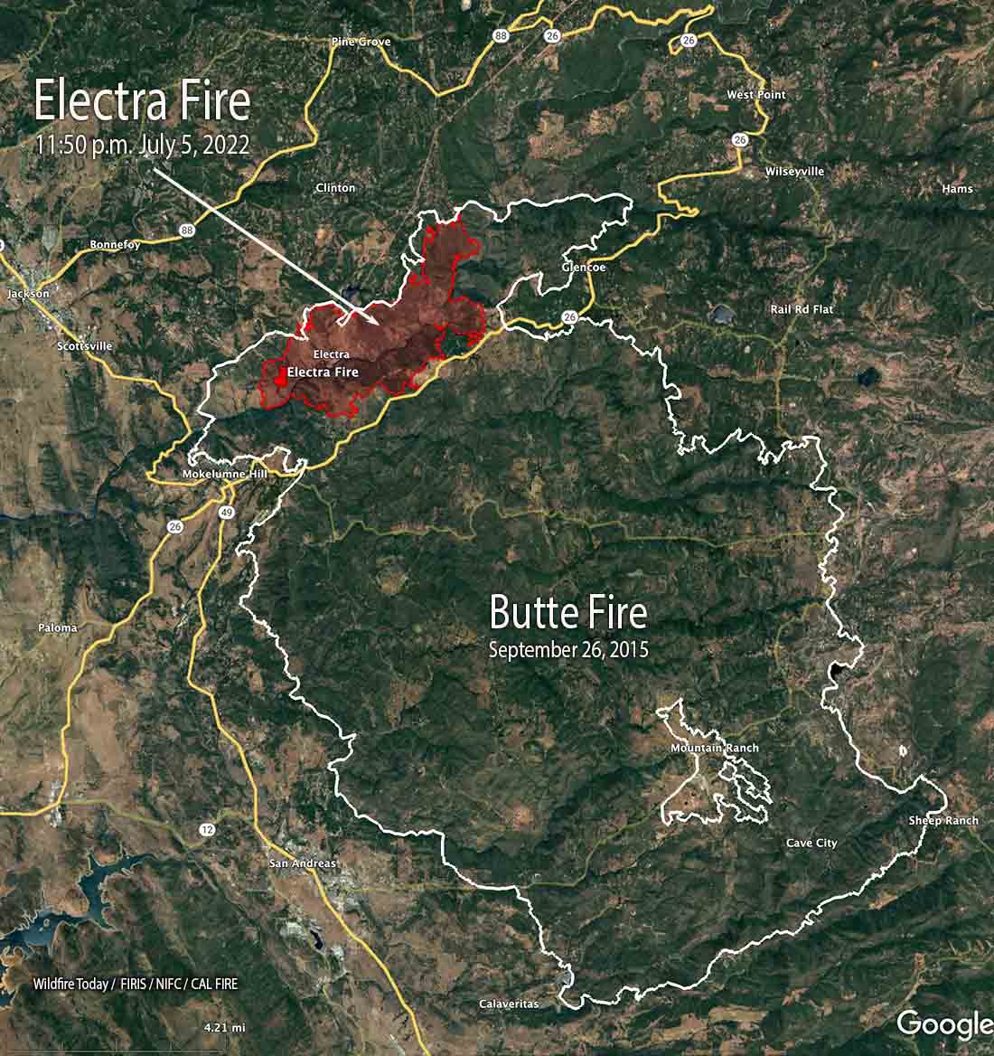
As of Tuesday night the 3,900-acre fire was almost entirely still within the footprint of the Butte Fire that burned more than 70,000 acres in September of 2015. It has burned both sides of the drainage along the Mokelumne River and reached but not crossed Highway 26 on the south side near Rich Gulch.

To see all articles on Wildfire Today about the Electra Fire, including the most recent, click HERE.

Electra Fire map 1150 p.m. MDT July 5, 2022
Map of the Electra Fire at 11:50 p.m. MDT July 5, 2022; and, the 2015 Butte Fire.

The most recent growth of the Electra Fire has been on the north and northeast sides, where firefighters are working to protect homes near Quail Drive and Clinton Bar Road. Where possible they are taking advantage of firelines used during the Butte Fire, firing out or backfiring from those areas.

The Amador County Sheriff’s office has created an online map showing the areas under evacuation orders.

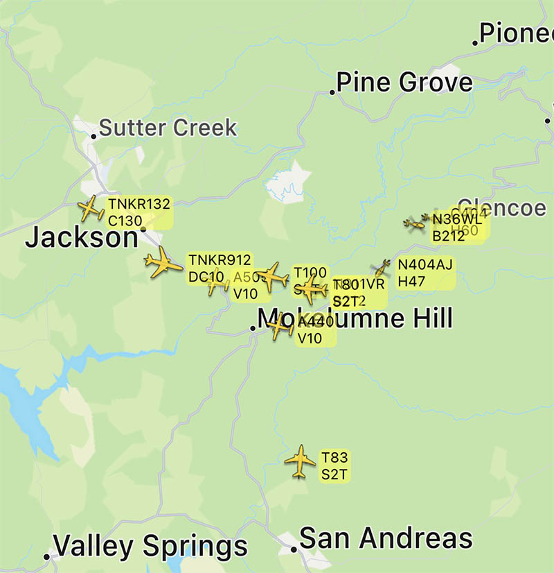
Resources on the fire Tuesday included 200 fire engines, 26 water tenders, 7 helicopters and 41 dozers for a total of 1,334 personnel.

The weather forecast for Wednesday calls for skies clearing in the afternoon, 84 degrees, 40 percent relative humidity, and 5-10 mph afternoon winds out of the southwest and west gusting to 15.

Two CAL FIRE firefighters, Emily Eymann and Jessica Moser, rescued a pair of dogs, loading them into a US Forest Service truck for evacuation as the Electra Fire approached.

Electra Fire prompts evacuations southeast of Jackson, CA

Approximately 5 miles southeast of Jackson

Updated 1:39 p.m. MDT July 5, 2022

Electra Fire history July 4, 2022
Map showing the current Electra Fire, as of Monday night, and the 2015 Butte Fire.

The activity on the Electra fire southeast of Jackson, California has been increasing since noon Tuesday. Several air tankers are dropping retardant, including a DC-10, MD-87, C-130, and S-2T.

The Amador County Sheriff’s office has created an online map showing the areas under evacuation orders.

To see all articles on Wildfire Today about the Electra Fire, including the most recent, click HERE.

As of the Monday night mapping data, the Electra Fire has been burning entirely within the footprint of the huge Butte Fire that blackened more than 70,000 acres in 2015 while leading to two deaths and 135 destroyed homes.

Electra Fire 12:33 p.m. July 5, 2022
Electra Fire, looking south from Mt. Zion at 12:33 p.m. July 5, 2022.
Map Butte Fire
CAL FIRE’s map of the Butte Fire obtained Sept. 12, 2015. No information was provided about the date of the perimeter.

Resources working the fire include 128 engines, 22 water tenders, 33 dozers, 39 hand crews, and multiple aircraft.

On Monday approximately 100 recreational visitors and PG&E employees had to shelter in the Electra Powerhouse, but were safely evacuated from the area by 9:30 p.m.

The control objectives are to keep the fire east of Hwy. 49, south of Hwy. 88, north of Jesus Maria Road, and west of Hwy. 26 and Railroad Flat Road.

About 450 structures are threatened.

The weather at the Golden Chain Highway weather station south of Jackson at 1:20 p.m. Tuesday was 80 degrees, 49 percent relative humidity, and 6 mph winds out of south gusting to 12 mph. The forecast is for the RH to drop to about 40 percent by late afternoon.  Monday afternoon while the large convection column was raging, the nearby weather stations recorded a minimum RH of around 60 percent — remarkably high for such vigorous fire behavior.

Electra Fire
Electra Fire at the Mokelumne River. July 4 or 5, 2022.

Updated 5:25 a.m. PDT July 5, 2022

Electra Fire map, Monday night July 4, 2022
Electra Fire map, Monday night July 4, 2022. Data from FIRIS.

The Electra Fire 5 miles south of Jackson, California grew substantially Monday evening and into the night, but the activity slowed in the very early hours of Tuesday. Most of the growth was on the north and east sides after it crossed the Mokelumne River and reached highway 26 near Rich Gulch.

The FIRIS mapping crew estimated the size at 3,034 acres at about 1 a.m. Tuesday.

Electra Fire 8:07 p.m. July 4, 2022
Electra Fire, looking north from the Buena Vista camera at 8:07 p.m. July 4, 2022.

6:00 p.m. MDT July 4, 2022

Electra Fire, location
Map showing the location of the Electra Fire.

The Electra Fire that started Monday afternoon near Electra Road approximately 5 miles southeast of Jackson, California has prompted evacuations. At 5:06 p.m. a mapping aircraft estimated the size at nearly 390 acres. It is on both sides of the Mokelumne River.

perimeter map of the Electra Fire
Approximate perimeter of the Electra Fire at about 5:20 p.m. July 4, 2022. FIRIS aircraft.

At 5:36 the Amador County Sheriff Office said a mandatory evacuation order has been issued for all residents in the Butte Mountain Road area. Butte Mountain Road will be closed except for egress purposes.

An evacuation warning is in effect for all residents in a two mile radius around Lake Tabeau.

Electra Fire 5:28 p.m. July 4, 2022
Electra Fire, looking northeast from the Buena Vista camera at 5:28 p.m. July 4, 2022.

Soon after it started the fire was putting up a very large plume of smoke topped by condensation and a pyrocumulus cloud, indicating extreme fire behavior.

Aircraft near the Electra Fire in Northern California
Aircraft near the Electra Fire in Northern California at 5:23 p.m. July 4, 2022. FlightRadar24.

Wildfire at Centerville, Utah prompts evacuations

The police reported that fireworks is the most likely cause, but it is under investigation

Updated at 5:03 p.m. MDT July 4, 2022

Deuel Creek Fire
Helicopter drops water on the Deuel Creek Fire Monday afternoon, July 4, 2022. Image from Division A.

The Deuel Creek Fire in the foothills east of Centerville, Utah was  mapped Monday at 128 acres. Firefighting resources assigned include multiple helicopters and 7 engines for a total of 80 personnel; an additional 3 hand crews are en route.

Monday afternoon the fire was less active than it was during the night, but still has potential for growth with the strong winds and low humidity. The fire is between Deuel Creek and Parrish Creek.


12:51 p.m. MDT July 4, 2022

Deuel Creek Fire map, 3:54 a.m. MDT July 4, 2022
The red dots on the map represent heat on the Deuel Creek Fire detected by satellites as late as 3:54 a.m. MDT July 4, 2022. Looking east.

A fire that was reported around midnight Sunday night resulted in the evacuation of about 89 homes on the east side of Centerville, Utah. It started near Center Street and Firebreak Road north of Bountiful. The evacuations were later lifted.

Fire authorities estimate it has burned approximately 100 acres, mostly on a steep slope 10 miles north of Salt Lake City.

“All indications are that this fire was human caused, the most likely source being fireworks,” wrote the Centerville Police Department on Twitter at 5:50 a.m. Monday. “We will be working with fire investigators to determine the cause.”

Much of Western Utah, including the greater Salt Lake City Area, has been under a Red Flag Warning Sunday and Monday for single-digit humidity and strong winds.

A Type 3 Incident Management Team will assume command of the fire Monday morning.

Regarding the tweet below, Spencer J. Cox is the governor of Utah.

Rices Fire prompts evacuations in Nevada County in Northern California

Updated at 5:18 p.m. PDT June 29, 2022

Map of the Rices Fire, by FIRIS, at ~9 a.m. June 29, 2022
Map showing the progression of the Rices Fire, by FIRIS, at ~9 a.m. June 29, 2022

At 1 p.m. Wednesday cameras pointed at the Rices Fire show that it is not putting up much smoke.

Rices Fire 1:02 p.m June 29, 2022
Rices Fire as seen from the Barr Ranch camera, looking north at 1:02 p.m June 29, 2022.

Mapping at mid-morning on Wednesday found it had burned 820 acres.


Updated at 9:07 a.m. PDT June 29, 2022

Rices Fire map
Rices Fire map, estimated perimeter, June 28, 2022.

Updated at 8:03 a.m. PDT June 29, 2022

Rices Fire, 7:29 a.m. June 29
Rices Fire, as seen from the Barr Ranch camera looking north at 7:29 a.m. June 29, 2022.

The spread of the Rices Fire in Northern California north of Bridgeport west of French Corral slowed overnight. The latest size estimate from CAL FIRE is 769 acres.

Tuesday night the relative humidity went up to 36 percent after reaching 6 percent Tuesday afternoon. Very early Wednesday morning the wind was from the northeast at 4 mph gusting to 10.

The spot weather forecast for Wednesday issued Tuesday afternoon, predicted 91 degrees, east winds 3 to 7 mph shifting to the southwest at 5 to 8 mph after 9 to 10 a.m., with 10 percent relative humidity. Without strong winds this is not considered extreme conditions, but with ultra low humidity and fuel moistures there will still be considerable resistance to control.


8:15 p.m. PDT June 28, 2022

A wildfire in Nevada County in Northern California is prompting evacuations near Birchville. Since it started at about 2 p.m. Tuesday it had burned approximately 520 acres by 6:30 p.m. It was reported near Rices Crossing and Cranston Roads and is believed to have originated from a structure fire that spread into vegetation.

Evacuation information is at CommunityZonehaven.com.

Rices Fire
Rices Fire, as seen from the Barr Ranch camera, looking north at 7:54 p.m. June 28 2022.

A nearby weather station Tuesday afternoon recorded a high of 100 degrees recorded, relative humidity as low as 6 percent with 6 mph southwest winds gusting to 15 mph. The forecast for Wednesday calls for 91 degrees, east winds 3 to 7 mph shifting to the southwest at 5 to 8 mph after 9 to 10 am., with 10 percent relative humidity.

We will post more information as it becomes available.

map Location of the Rices Fire, June 28, 2022.
Approximate location of the Rices Fire, June 28, 2022.
Rices Fire, satellite photo map, 7:31 p.m. PDT June 28, 2022
Rices Fire, satellite photo, 7:31 p.m. PDT June 28, 2022

Firefighters attack Ridge Fire near Mt. Shasta community in Northern California

9 a.m. PDT June 26, 2022

map Location of Ridge Fire
Map showing the location of the Ridge Fire at 1 a.m. June 26, 2022.

At about 9 p.m. Saturday firefighters responded to the Ridge Fire two miles northwest of the city of Mt. Shasta, west of Interstate 5 in Northern California. Infrared cameras showed multiple heat sources. It is not known if there was more than one ignition or if spot fires occurred from a single fire. The size estimate from CAL FIRE is 10 acres.

It is in an area with difficult access, on private land about a quarter mile outside the Shasta-Trinity National Forest.

The weather after sunset at the Mt. Shasta weather station two miles away in the community, recorded 2 mph winds out of the southeast switching to the northeast after 9 p.m. The relative humidity in the town, which may not be representative of conditions near the fire on ridge, increased overnight from 10 to 63 percent.

The forecast for Sunday at the fire area calls for 93 degrees, 12-15 percent relative humidity, and 2 to 6 mph winds out of the southeast becoming south in the afternoon.

Ridge Fire
Ridge Fire as seen from Mt. Bradley, 8:21 a.m., June 26, 2022.

Dempsey Fire west of Mineral Wells, continues to challenge Texas firefighters

Dempsey Fire, June 25, 2022. Texas Forest Service
Dempsey Fire, June 25, 2022. Texas Forest Service.

The Dempsey Fire six miles west of Mineral Wells, Texas has crossed the Brazos River in several places. It was very active again Saturday, but not to the extreme levels seen on Friday.

When the fire was mapped by an aircraft at 8 p.m. Saturday the northwest side had reached Fortune Bend Road and spotted across. The northeast side of the fire was close to Wrangler Field and had not reached Grassy Ridge Road or Lewis Road. It was about three miles south of Graford, one mile west of highway 337, and two to three miles south of highway 254.

To see all articles on Wildfire Today about the Dempsey Fire, including the most recent, click HERE.

The size at that time, accounting for the large unburned areas along the river, was about 10,000 acres. Sunday morning the Texas Forest Service reported it had burned 11,597 acres.

Dempsey Fire map, 8 p.m. CDT June 25, 2022
Dempsey Fire map, 8 p.m. CDT June 25, 2022.

On Saturday crews continued to construct line, hold the fire along roadways, engage spot fires, and hold the fire along the Brazos River where they could. Aircraft assisted firefighters on the ground with drops from helicopters and air tankers.

Dempsey fire morning briefing, June 26, 2022
Dempsey fire morning briefing, June 26, 2022. Texas Forest Service.

The weather forecast for the fire area issued at 5:55 a.m. Sunday calls for sunny skies becoming partly cloudy after 3 p.m., 100 degrees, 25 percent relative humidity, and 9 to 13 mph winds out of the west shifting to the northeast in the afternoon with gusts to 23 by 5 p.m. The variable wind direction should slow the growth to the north, but will be a challenge to firefighters as they work to remain safe as the direction of spread changes.

Dempsey Fire, satellite photo, 5:31 p.m. CDT June 25, 2022
Dempsey Fire, satellite photo, 5:31 p.m. CDT June 25, 2022. NOAA.
Dempsey Fire
Dempsey Fire, the afternoon of June 25, 2022. Texas Forest Service.