Forest Service hoped to have 16 CWN air tankers working, but could only find 5

There are also 18 large air tankers working now under Exclusive Use contracts

Wrentham Market Fire
An MD-87 air tanker drops on the Wrentham Market Fire in northern Oregon, June 29, 2021.

This article was first published at Fire Aviation.

More than 21,000 personnel are battling 66 large wildfires in the early portion of an extremely busy fire season and the US Forest Service (FS) has activated all of the privately owned large air tankers (LATs) that they possibly can. There are no more available in the country.

The FS is the federal agency responsible for contracting for the large fire-slowing aircraft that can carry 3,000 to 4,000 gallons of retardant, or in the case of the DC-10’s, up to 9,400. The FS does not operate any government-owned air tankers; they are all privately owned, working under contracts administered by the FS.

As this is written on July 28, there are 18 LATs active on Exclusive Use (EU) contracts and 5 on Call When Needed (CWN) contracts, for a total of 23. In addition, the FS has borrowed the only LAT that Australia has, a 737, which flew across the Pacific a few days ago.

Five military C-130 Modular Airborne FireFighting Systems (MAFFS) have been called into action that can carry up to 3,000 gallons of fire retardant. Theoretically there should be eight available at all times during the fire season, but we were unable to find out from the FS if it would be possible to activate the additional three.

Some of us who follow the industry and aerial firefighting may or may not be surprised that the FS could only muster 23 LATs on EU or CWN contracts, because for years the agency has told the public and Congressional Committees that they have “up to 35 (or 34)” air tankers.

On May 17, 2021 Fire Aviation was told by a spokesperson for the FS that this year they would have 34 LATs if needed — 18 on Exclusive Use Contracts guaranteed to work, 8 “surge” LATs guaranteed to work for a shorter period of time, and another 8 on Call When Needed (CWN) contracts. Of those 16 surge and CWN aircraft, only 5 could be produced.

In a Senate Committee hearing on June 9, 2020 John Phipps, US Forest Service Deputy Chief for State and Private Forestry said, “We have up to 35 large air tankers (LATs)… and we are well under way for our planning and preparedness for the upcoming western fire season.”

On December 5, 2019 the FS said they had signed Call When Needed (CWN) agreements for air tanker services with six companies for a total of 35 aircraft. The number “35” was misleading because most if not all of the 13 large air tankers on exclusive use (EU) contracts at the time also had CWN contracts; some were being double-counted. That brought the CWN number down to around 22.

It turns out that leaning on that “up to” 34 or 35 number year after year has been a very weak crutch. “Up to 35” can mean any number between zero and 35. It should not be that difficult to count these huge aircraft, especially considering how much they cost to operate.

Some of the Western states have either realized that they can’t count on the federal government to supply them with air tankers when the need arises, or they have recently adopted a more aggressive approach to attacking new fires. Three states this year have leased a total of five LATs that are inspected and carded by the FS, capable of working on EU or CWN contracts for the FS if they had been offered the opportunity. California has augmented their fleet of 23 S-2T’s with two BAe-146’s and one MD-87, Colorado has hired one BAe-146, and Oregon is leasing an MD-87. In addition, the state of Washington has picked up on contract one LAT that had been working on an Alaska contract, a Q-400 operated by Conair. As far as I know the Canadian-converted Q-400 has not been blessed by the Interagency Air Tanker Board in the US, but the state organizations are not bound by that organization. There are also a handful of 1,600-gallon scoopers (CL-415 type) working for states, and too many 700-gallon single engine air tankers to count.

“Three [aircraft that have Forest Service CWN contracts] are operating in Canada,” said Stanton Florea, a Fire Communications Specialist for the FS. “Seven are not operational. They were either not built as airtankers, the companies cannot staff them, or the companies are not making them available to be on contract.”

There is a possibility, Mr. Florea said, that Canada could loan the US some air tankers or scoopers if they were available, through an agreement between the US National Interagency Fire Center and the Canadian Forest Fire Centre. However, the provinces of British Columbia, Manitoba, and Ontario have their hands full with their own fires — they are flying in firefighters from Australia to provide assistance.

CWN aircraft may or may not be immediately available during the fire season, with mechanics and crew members available to suddenly drop what they were doing and start flying fires. In 2017 the average daily rate for large federal CWN air tankers was 54 percent higher than aircraft on exclusive use contracts. But CWN costs are charged to the virtually unlimited fire suppression accounts, so the Forest Service does not care about using taxpayer’s dollars in that manner. And they are not held accountable.

While these numbers may have changed since 2018, it is unlikely that the differential between EU and CWN has changed much.

Over the last 10 years the average number of LATs on EU Forest Service contracts was 14.0 for the United States. The average number on EU contracts from 2000 through 2009 was 28.3. This year there are 18, which is 5 more than last year.

The FS goes as far as they can with the limited, insufficient funds appropriated by Congress and approved by the President. If the planes don’t exist when needed, new and emerging wildfires can more easily escape initial attack and grow into huge blazes, or megafires that can consume more than a million dollars of taxpayer funds each day. In the 14 days the Dixie Fire has been burning homes and hundreds of thousands of acres in Northern California, it has also been eating an average of $4.5 million in suppression funds every day. If some of that was instead spent on prescribed burning and additional EU air tankers, it might save money in the long run.

One of the lessons learned this year and others like it, is, Congress must appropriate adequate funds for the five land management agencies to pay firefighters a living wage, conduct more prescribed fires, and have at least 40 large air tankers and 50 large Type 1 helicopters on exclusive use 10-year contracts instead of 1-year contracts.

The peak of the Western US wildfire season is usually in August, but in 2020 the day with the highest number of fire personnel mobilized was September 19 when the record was set with 32,727 assigned to wildfires.

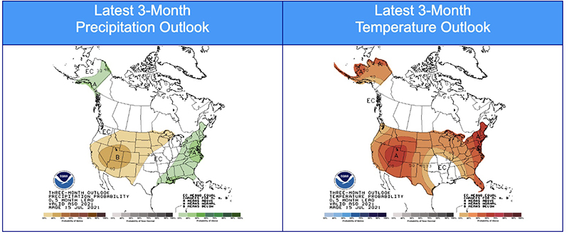
The outlook for August, September, and October predicts weather that will be hotter and drier than average for the Western US, which, if accurate, will lead to an above average fire season in the Western US. The live fuel moistures and Energy Release Components in many areas are already near or above the all time extremes.

Three-month outlook
Three-month outlook for August, September, and October, 2021.

Firefighters are utilizing tactical firing operations to slow spread of the Dixie Fire

The blaze south of Chester, California has burned more than 212,000 acres

Dixie Fire map,
Dixie Fire map. The white line was the perimeter at 11 p.m. PDT July 27, 2021. The green line was the perimeter about 48 hours earlier. The red dots represent heat detected by a satellite at 2:49 a.m. PDT July 28, 2021.

A mapping flight Tuesday night found that the Dixie Fire south of Chester, California grew by about 14,000 acres in 24 hours, to bring the total up to 212,799 acres. Much of the expansion was on the northwest side where crews are preparing firelines and conducting burning operations when the weather cooperates. There was also movement on the east side north of Bucks Lake where difficult, rocky terrain is a challenge for firefighters, and near Twain and Crescent Mills. Another burning operation has been ongoing on the Mt. Hough road northeast of Quincy.

To see all articles on Wildfire Today about the Dixie Fire, including the most recent, click HERE.

The Incident Management Team reports that 34 structures have been destroyed, in addition to another 19 described as minor.

Resources assigned to the fire Tuesday evening included 82 crews, 319 engines, and 34 helicopters, for a total of 5,301 personnel.

The thick layer of smoke over the southern half of the fire lifted Tuesday morning and early afternoon, but smoke settled into the lower elevations in the evening. Air operations were also active Tuesday, including on the south perimeter near Bucks Lake. Trace amounts of rain fell in localized spots of the fire which slowed the progression of the fire and limited firefighters’ tactical firing operations.

Channel 7 KRCR has an interesting story about how firefighters have been applying large amounts of water about two miles northeast of the fire in the community of Taylorsville, in an effort to keep things wet in case of an ember shower.

Man fires several shots at Firehawk helicopter in Southern California

The person was found and arrested after an hours-long search

Joshua James Chimarusti
Joshua James Chimarusti. Photo by Ventura County Sheriff’s Department.

On Thursday morning, July 22, 2021, Joshua Chimarusti was arrested after he fired several rounds from a handgun at a Ventura County Firehawk helicopter in Southern California.

On July 21, 2021 at approximately 9:15 PM, the crew of Ventura County Firehawk Copter 4 was conducting nighttime training operations in Lake Casitas when they became aware of gunfire directed at them. The pilot of Copter 4 took evasive action and identified a suspect vehicle leaving the area at a high rate of speed.  Copter 4 followed the suspect vehicle into Oak View where it came to a stop in the 200 block of Olive Street. The suspect, who was later identified as Joshua Chimarusti, exited the vehicle, and fired additional shots from a handgun at Copter 4. Mr. Chimarusti ran away to avoid being arrested.

An extensive search of the area was conducted by by patrol Deputies, various investigative units, K9, UAV, a small SWAT contingent, and Ventura County Copter 3. Mr. Chimarusti was ultimately located and taken into custody in the early morning hours of July 22, 2021. The handgun he used during both shootings was also located and seized as evidence. Ventura County Copter 4 did not sustain any damage from the incident.

Mr. Chimarusti was arrested and booked for attempted murder, assault with a firearm upon a peace officer or fire fighter, shooting at an occupied aircraft, discharge of a firearm with gross negligence, prohibited person in possession of a firearm, and carrying a loaded unregistered firearm. He had a court appearance scheduled for arraignment in Ventura County Superior Court on July 26.

Ventura County FireHawk
File photo of Ventura County FireHawk Copter 4 testing new tanks at 69Bravo, June 9, 2021 near Topanga, California . Photo from 69Bravo cameras.

Ventura County purchased three military HH-60L Blackhawk helicopters and is converting them into FIREHAWKS that will be used for fighting wildland fires, personnel transport, search and rescue, law enforcement, and medical evacuation.

The County has a joint Fire Department and Sheriff’s Department Aviation Unit. In addition to the FIREHAWKS, they have one Bell 206 Jet Ranger, one Bell 212 HP, one Bell 205B, and two UH-1A Hueys.

Firefighter reported missing on Montana wildfire found hours later

Granite Pass Complex
Map showing heat detected by a satellite on the Granite Pass Complex during the seven-day period that ended July 26, 2021.

A firefighter on the Granite Pass Complex about 28 air miles southwest of Missoula, Montana was found about five hours after he was reported missing July 25.

The individual had been scouting an area suitable for a fireline and missed his scheduled check-in. At about 7:30 p.m. Missoula County Dispatch was notified of the missing firefighter, and California Interagency Incident Management Team 15 began multiple attempts to contact him. After there was no success, the team began to search by ground and air.

Missoula County Sheriff’s Office Deputies and Missoula County Search and Rescue were dispatched at 8:20 p.m. The individual’s vehicle was located in the vicinity of the White Mountain Lookout and Pilot Knob, southwest of Missoula at approximately 9:40 p.m.  The Missoula County Search and Rescue and the Sheriff’s Office issued a Mutual Aid Request to Two Bear Air for aviation assistance. Airspace was cleared with the Incident Management Team and Two Bear Air began assisting Missoula County Search and Rescue ground resources.

The individual who had been reported missing realized they were not in their intended location and could not contact anyone by radio or phone. To minimize impacts to himself and local search and rescue resources, he explained later that he found an area suitable to stay the night.

He was located by Missoula County Search and Rescue just after midnight on July 26, 2021. He was tired and thirsty but uninjured and able to make his way out unassisted by search personnel.

Two Bear Air provides aviation support in portions of the Northwest to search and rescue teams. It is run by a philanthropist at no cost to taxpayers. Fire Aviation has several articles about the organization.

The Granite Pass Complex consists of four wildfires burning in the vicinity of Lolo Pass on the Nez Perce-Clearwater National Forests in Idaho and the Lolo National Forest in Montana. They are being managed together under one Type 2 Incident Management Team. Since the fires started from lightning on July 12 they have burned a total of about 3,700 acres.

Granite Pass Complex firefighters
A fire crew from Georgia works on the Granite Pass Complex of fires. Posted July 24, 2021 on InciWeb.

Tamarack Fire lifts evacuation orders for nearly 2,000 residents

The fire 15 miles southeast of South Lake Tahoe has burned more than 67,000 acres in California and Nevada

10:32 a.m. PDT July 26, 2021

Fire history, Tamarack Fire
Map showing the perimeter of the Tamarack Fire July 25, and the history of fires in the area since 1990.

Law enforcement authorities in Alpine and Douglas Counties ended evacuations Sunday in 15 communities near the Tamarack Fire 15 miles southeast of South Lake Tahoe, enabling nearly 2,000 residents to return to their homes. The number of people still under evacuation orders is now approximately 300. A map is available showing the current status of evacuations.

The fire has burned 67,764 acres.

Monday morning authorities reopened Highway 395 on the east side of the fire and Highway 88 on the west.

The fire history map above shows that the Tamarack Fire burned into the footprints of multiple fires from previous years, including Washington (2015), Slinkard (2017), Holbrook (1994), and possibly Tre (2012). Not shown on the map is the East Fork Fire that burned in the notch in the perimeter east of Woodfords a few weeks before the Tamarack Fire. Depending on the vegetation type and the recency of the earlier burn, a new fire will usually slow down when it encounters a fire footprint, exhibiting less resistance to control. If it is not too windy, a combination of aerial and ground-based firefighters can often be effective in slowing or stopping the spread in those areas.

Tamarack fire
Tamarack fire July 25, 2021. The brown areas represent evacuation zones. Map produced by the fire Incident Management Team. Accessed at 9:30 a.m. PDT July 26, 2021.

The National Situation Report indicates that 15 structures have burned. A map is available showing the location of destroyed and damaged structures.

Hand crews were able to complete containment of the northern edge and several other critical locations on the fire Sunday. Monday’s priorities include finishing containment on the northeast corner and securing more of the southern edge.

Thunderstorms are in the forecast Monday afternoon, and there is a chance for rain into the evening.

Southeast side of Tamarack Fire
Southeast side of Tamarack Fire July 25, 2021. InciWeb.