Tamarack Fire spreads east, crosses state line into Nevada

Burns 8 structures and over 50,000 acres

12:42 p.m. PDT July 22, 2021

Tamarack Fire map
Tamarack Fire map. The white line was the perimeter at 8 p.m. PDT July 21, 2021. The green line was the perimeter about 24 hours before.

From the Incident Management Team, Thursday morning, July 22:

There was active fire behavior [Wednesday] afternoon with crowning, short crown runs and prolific spotting as the winds  built up. Fuels remain extremely dry. The fire grew about 10,000 acres [Wednesday] to approximately 50,129 acres. It pushed to Hwy 395 and burned north and south along the highway but did not cross the highway. Active fire also pushed towards, but didn’t cross, Hwy 88 as firefighters were able to keep the fire south of the highway. Hwy 88 & 89 remain closed in the fire area to all traffic except incident personnel. A portion of Hwy 395 closed [Wednesday] for firefighter and public safety.

Over 800 people have been evacuated and over 500 structures are threatened. There are over 1,200 personnel working on the fire and more resources are on order. Firefighting operations continued throughout the night. Night operations include structure protection and firing operations when conditions are right.

The objective for managing the fire is full suppression, and all efforts will be directed towards meeting that objective with public and firefighter safety as the highest priority. Uncontrolled fire with extreme fire behavior continues to be a threat to surrounding communities, public, and firefighters.

Wednesday afternoon the fire was pushed by 15 to 25 mph winds gusting out of the west and southwest up to 33 mph while the relative humidity was in the low teens. The forecast for the east side of the fire Thursday afternoon calls for 82 degrees, 15 percent RH, and 15 mph winds gusting out of the southwest at 24 mph. This could put more pressure on the Highway 395 corridor.

To see all articles on Wildfire Today about the Tamarack Fire, including the most recent, click HERE.

On Friday, conditions will be similar but with winds maxing out at 7 mph from variable directions.

Satellite photo fires in CA WA OR

The National Situation Report for Thursday reduced the number of reported structures destroyed from 10 to 8.

Resources assigned to the fire Wednesday evening included 27 crews, 96 engines, and 9 helicopters for a total of 1,213 personnel.


7:33 a.m. PDT July 21, 2021

Map of the Tamarack Fire
Map of the Tamarack Fire. The white line was the perimeter at 6 p.m. PDT July 20. The Green line was the estimated perimeter about 24 hours before. The red dots represent heat detected by a satellite at 3:18 a.m. PDT July 21, 2021.

The Tamarack Fire spread further east on Tuesday, crossing the state line from California into Nevada (see map above). The fire started July 4 southwest of Markleeville, California and from that point has now spread 15 miles northeast and 10 miles to the north.

After it passed the state line near Leviathan Mine Road it continued east. During a satellite overflight at 3:18 a.m. PDT Wednesday July 21 it was about two miles west of US Highway 395 and 5 miles northwest of the junction of 395 and Highway 208.

Satellite Photo, Dixie and Tamarack Fires
Satellite Photo, Dixie and Tamarack Fires at 6:26 p.m. PDT July 20, 2021.

The Incident Management Team reports that 10 structures have been destroyed.

Tuesday night voluntary evacuations were issued “for all residents in Leviathan Mine Rd. and Holbrook Junction areas.” More information is at InciWeb.

A mapping flight at 6 p.m. PDT Tuesday determined that the fire had burned about 41,800 acres, but it continued burning later into the evening.

Resources assigned to the fire Tuesday evening included 27 hand crews, 99 engines, and 9 helicopters for a total of 1,219 personnel.

Poll: how many fire personnel will be mobilized this year?

Dixie Fire, July 20, 2021
Dixie Fire, July 20, 2021. AlertWildfire.

It’s not even August yet, and the National Interagency Coordination Center’s Incident Management Situation Report showed today that over 19,000 personnel are assigned to wildfires. On Sept. 19, 2020 there were 32,727, the highest number ever recorded.

Will the highest daily number this year be OVER or UNDER that record set last year?

Choose Over or Under in the poll below, then click on the hard to see VOTE button. The poll will close at the end of the day July 31, 2021.


Will the highest number of personnel mobilized at one time for fires this year be OVER or UNDER the record of 32,727 set in 2020?

  • Over (72%, 482 Votes)
  • Under (28%, 192 Votes)

Total Voters: 674

Loading ... Loading ...

Dixie Fire grows to nearly 60,000 acres in Northern California

25 miles north of Oroville

Updated at 7:17 p.m. PDT July 20, 2021

Map of the Dixie Fire
Map of the Dixie Fire. The white line was the perimeter July 19. The red dots represent heat detected by a satellite at 3 p.m. PDT July 20, 2021.

The Dixie Fire 13 air miles northeast of Paradise, California was very active again Tuesday afternoon. The convection column of smoke did not reach the towering heights seen in previous days, probably because the 15 to 20 mph winds recorded at Flea Mountain gusting between 20 and 28 mph mitigated massive vertical development, blowing the smoke rapidly off to the northeast.

(To see all articles on Wildfire Today about the Dixie Fire, including the most recent, click HERE.)

A satellite overflight at 3 p.m. (see the map above) showed large amounts of heat on the north  and northeast sides — north and south of Highway 70. At that time the fire was moving closer to the communities of Twain, Caribou, and Paxton.

Satellite Photo, Dixie and Tamarack Fires
Satellite photo, Dixie and Tamarack Fires at 6:26 p.m. PDT July 20, 2021.
Dixie Fire
Dixie Fire as seen from Bald Mountain, looking NE at 1:23 p.m. PDT July 20, 2021. AlertWildfire.

2:23 p.m. PDT July 20, 2021

Firefighters on the Dixie Fire
Firefighters on the Dixie Fire. Strike Team 9163G looking at a very impressive pyrocumulus cloud, July, 2021. CAL FIRE photo.

The Dixie Fire grew by tens of thousands of acres Monday, reaching 59,984 acres by the end of the day. It now stretches for about 15 miles along the Feather River Canyon and Highway 70, an area known for its steep, barely accessible terrain.

The fire is burning on both sides of the canyon, an area where firefighters have in the past had problems with radio communication caused by the steep slopes.

It is moving to the north and northeast during the day. After sunset Monday, down-canyon winds brought smoke to lower elevations south and southwest of the fire.

Satellite Photo, Dixie Fire
Satellite Photo showing smoke from the Dixie Fire 12:31 p.m. PDT July 20, 2021. NOAA GOES 17.

Evacuation orders are in effect for some areas in Plumas and Butte Counties. A map is available, and CAL FIRE has other evacuation information.

Resources assigned Tuesday morning included 63 hand crews, 23 helicopters, 141 engines, 49 dozers, and 29 water tenders for a total of 2,409 personnel.

The fire has burned very close to communities in Feather River Canyon, including Dixie, Tobin , Belden, Storrie, Rock Creek, and Rodgers Flat. There are reports that at least two structures have been destroyed, but CAL FIRE has not released any information on the topic since the fire started on July 14. Other towns north and northeast of the fire are Caribou, Twain, Paxton, Crescent Mills, and Greenville. Monday night Lake Almanor was about 9 miles northeast of the head of the fire.

Map of the Dixie Fire
Map of the Dixie Fire, showing the location at the end of the day on July 19, 2021. CAL FIRE.

The image below shows a sample of the aircraft that were working on the fire at 1:13 p.m. PDT July 20, 2021. The fire is at upper-right, and the Chico Airport, where some air tankers are reloading, is at lower-left.  Others not seen were flying south to reload at Sacramento McClellan Airport. Observed at this point in time were several helicopters, an MD87, a BAe-146, two S-2Ts, air attack aircraft, and two military C-130s equipped with Modular Airborne FireFighting Systems.

aircraft on the Dixie Fire
Some of the aircraft on the Dixie Fire at 1:13 p.m. PDT July 20, 2021. Flight Radar 24.

PG&E says their equipment may have started the Dixie Fire

The fire has burned more than 30,000 acres 25 miles north of Oroville, California

4:08 p.m. PDT July 19, 2021

Dixie Fire 3-D map
Dixie Fire 3-D map July 18, 2021.

In a report to the California Public Utilities Commission, Pacific Gas and Electric explains that on July 13 the company’s equipment may have ignited the Dixie Fire which has burned more than 30,000 acres along Highway 70. The fire is 25 miles north of Oroville. It has burned over or around the communities of Dixie, Merlin, Rock Creek, Storrie, Tobin, and Belden. Remarkably, CAL FIRE has not reported any burned structures, but says 810 are threatened.

PG&E said that at 7 a.m. on July 13 their system detected a loss of power in Feather River Canyon. From a distance their troubleman could see what looked like a blown fuse on a 12 kV power line. Because of challenging terrain and a closed bridge, the report said, another 9 hours and 40 minutes elapsed before he could access the site. He found that two fuses were blown and a live tree was leaning onto the power line. There was a fire on the ground near the base of the tree.

(To see all articles on Wildfire Today about the Dixie Fire, including the most recent, click HERE.)

At that time the company called 911 to report the fire. The operator said they were aware of the fire and units were responding.

The Dixie Fire has burned 14 miles northeast through Feather River Canyon and stretches 5 miles northwest from the river.

Map of the Dixie Fire
Map of the Dixie Fire. The white line was the perimeter July 18. The red dots represent heat detected by a satellite at 3:54 a.m. PDT July 19, 2021.

The fire was very active Saturday and Sunday moving to the east and north, becoming well established on the southeast side of the Feather River, mirroring what was happening on the other side of the canyon.

Firefighters are constructing direct fire lines to stop the spread and are building indirect contingency lines to protect the communities at risk. Much of the fire is in steep terrain.

Evacuation orders are in effect for some areas in Plumas and Butte Counties. A map is available, and CAL FIRE has other evacuation information.

Dixie Fire
Dixie Fire as seen from Jarbo Gap, looking northeast at 4:04 p.m. PDT July 19, 2021.

Resources assigned to the Dixie Fire Monday morning included 54 hand crews, 17 helicopters, 110 engines, 29 dozers, and 19 water tenders for a total of 1,918 personnel.

Below is very impressive video of pyrocumulus (the white cloud) forming over the intensely burning Dixie Fire Sunday afternoon.

Suspect fires handgun at airport in Idaho, firefighters flee

A 911 caller said the suspect was attempting to steal a helicopter

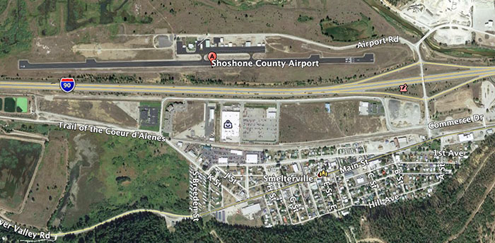
Map, Shoshone County Airport
Map, Shoshone County Airport. Wildfire Today / Google Earth.

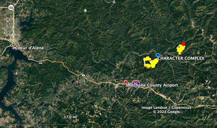
On Saturday July 17, wildland firefighters at the Shoshone County Airport in Smelterville, Idaho 30 miles southeast of Coeur d’Alene, encountered a dangerous situation that is not covered in the dozens of training courses they take.

From the Shoshone County Sheriff’s Office:


At approximately 5:52pm, Shoshone County Sheriff’s Office (SCSO) dispatch received a 911 call reporting an armed subject approaching fire personnel in their helicopter at the Shoshone County Airport in Smelterville Idaho. A second 911 caller reported the subject was attempting to steal a helicopter.

At the airport during this incident, there were between 30 to 70 fire fighter personnel present on scene due to the local active fires.

At approximately 5:57pm, a SCSO Deputy arrived on scene and quickly located the armed suspect (Oregon resident). The suspect then discharged a handgun several times into the ground and air as fire fighter personnel were fleeing the immediate area. The SCSO Deputy ordered the suspect to drop the weapon, he complied soon after and was taken into custody with the assistance of a 2nd SCSO Deputy and an Idaho State Police Trooper without further incident. Several other SCSO units and other law enforcement agencies arrived shortly after.

For clarification, NO law enforcement officers discharged a firearm and no one was injured during this incident.

The investigation is ongoing and no further information will be released at this time.

End of Shoshone County Sheriff’s Office report.


In the video below, the narrator says he’s at the Kellogg, Idaho airport. Kellogg is immediately east of Smelterville.

Map, Shoshone County Airport
Vicinity map, Shoshone County Airport. Google Earth.