Cameron Peak Fire spreads south and east

The fire is west of Fort Collins, Colorado

Updated October 18, 2020   |   7:52 a.m. MDT

The map above shows the perimeter of the Cameron Peak Fire collected by a USFS fixed wing aircraft at 9:47 p.m. MDT Oct. 17, 2020. The red shaded areas represent intense heat. Processed by Wildfire Today. The preliminary mapped size was 203,251 acres, a number that may be fine-tuned later.


Updated October 17, 2020   |   12:50 p.m. MDT

We are trying something new on Wildfire Today — creating a Google Map containing the perimeter of the Cameron Peak Fire. One of the main differences from our usual maps is that you can zoom in to see more detail. But keep in mind the perimeter is the approximate location, and can rapidly change as the fire spreads. The data came, as usual, from an overnight USFS fixed wing mapping flight. Let us know your thoughts about this type of map.


Updated October 17, 2020   |   7:53 a.m. MDT

Cameron Peak Fire map
Map of the active part of the Cameron Peak Fire. The red line was the perimeter at 9:58 p.m. MDT October 15, 2020. The white line was the perimeter about 24 hours before.

Strong winds throughout Friday night pushed the Cameron Peak Fire to the south and east. After 7 p.m. sustained wind speeds at the Colorado State University Mountain Campus weather station were from the west-southwest at 23 to 39 mph gusting at 35 to 66 mph.

Extreme fire behavior and spotting a mile ahead has been reported by firefighters. Approximately 31,220 structures are threatened.

In light of the strong winds, the incident management team ordered an additional 200 structural fire engines with associated supervisory personnel.

Since the fire started August 13, four residences and 96 other structures have been destroyed.

A fixed wing aircraft mapping flight at 10:20 p.m. Friday showed the fire edge had spread about two miles to the south over the previous 24 hours. Satellite overflights around 3 a.m. showed significant additional heat to the south, but the sensors could have been detecting heat in the smoke column, rather than fire on the ground.

The weather forecast for the east side of the fire on Saturday predicts sustained 22 to 28 mph winds out of the west-northwest gusting at 37 to 46 mph. The high temperature should be 60 degrees with 28 percent relative humidity. The wind will decrease after sunset, slowing to 3 to 5 mph out of the south or southwest by 12 p.m.

The mapping flight at 10:20 p.m. Friday estimated the size of the Cameron Peak Fire at 187,537 acres, but that figure may be fine-tuned by the incident management team, especially if they include fire spread that occurred after the flight.
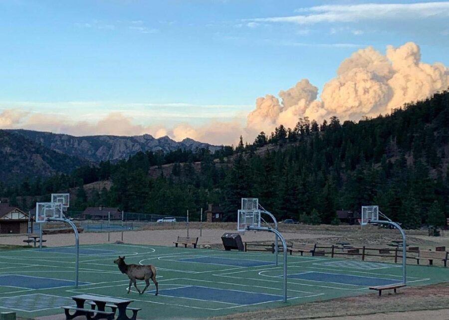
Cameron Peak Fire
Cameron Peak Fire, as seen from the Estes Park YMCA October 16, 2020. InciWeb.

Updated October 16, 2020   |   9 p.m. MDT

Map Cameron Peak Fire Colorado
Map of the Cameron Peak Fire. The red line was the perimeter at 9:58 p.m. MDT October 15, 2020. The red dots represent heat detected by a satellite at 1:24 p.m. MDT October 16, 2020.

The Cameron Peak Fire west of Fort Collins, Colorado has been extremely active on Friday, forcing firefighters to withdraw for their own safety from Miller Creek, The Retreat, and Storm Mountain.

Additional mandatory evacuations were ordered for Highway 34 from the Dam Store to just west of Soul Shine Road. More voluntary evacuations are also in effect. Larimer Emergency Telephone Authority (LETA) has details about the evacuations. NOCOALERT has maps of the areas.

Friday evening the incident management team reported the fire had burned 173,536 acres.

Cameron Peak Fire Colorado smoke
Cameron Peak Fire, from the Estes Park Safeway 10-16-2020. InciWeb.

Since 1 a.m. on Friday the weather has been very favorable for rapid fire spread. Overnight a weather station at the Colorado State University Mountain Campus recorded 30 degrees, relative humidity in the mid-teens, and a 10 mph west wind gusting at 20 to 30 mph.

Conditions worsened after sunrise Friday with temperature in the 50s, humidity remaining in the mid-teens, and 10 to 30 mph southwest to west winds gusting at 22 to 48 mph. By 6 p.m. the wind had calmed a bit — 10 mph with gusts of 20 to 35 mph.

The weather forecast for the east side of the Cameron Peak Fire calls for very strong winds Friday night through 10 p.m. Saturday, 22 to 29 mph out of the west or northwest gusting at 29 to 46 mph. The high temperature will be in the low 60s Saturday and around 50 Sunday. The relative humidity will be around 30 percent Saturday and in the high 40s Sunday. These conditions could be favorable to additional spread of the fire to the east Friday night and Saturday.

Breezy conditions take over Sunday at noon through Tuesday with 8 to 10 mph winds out of the west gusting at 17 to 22 mph. The minimum humidity will be around 40 percent.
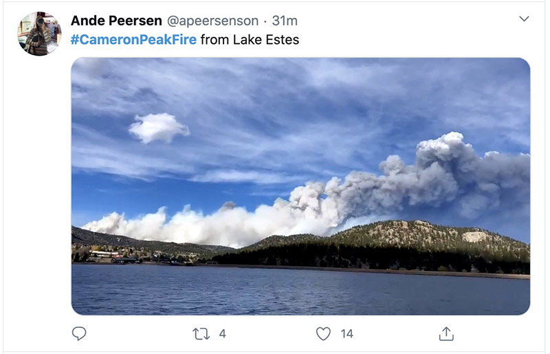
Cameron Peak Fire Colorado smoke
Cameron Peak Fire by @Apeersenson. Posted at 5:29 p.m. MDT 10-16-2020.
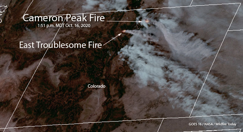
Cameron Peak Fire Colorado satellite photo
Cameron Peak Fire. Satellite photo at 1:51 p.m. MDT 10-16-2020.
smoke forecast Cameron Peak Fire Colorado
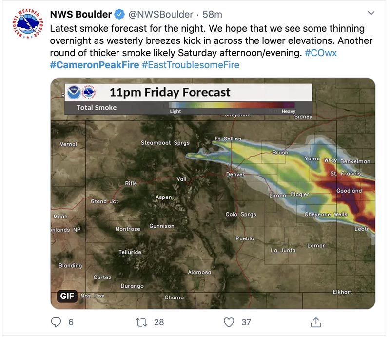
Cameron Peak Fire smoke forecast for 11 p.m. Friday 10-16-2020.

Trump administration reverses decision to deny California’s request for fire disaster assistance

A disaster declaration allows cost-sharing for damage, cleanup and rebuilding

Updated October 16, 2020   |   3:25 p.m. MDT

Friday afternoon the Trump administration reversed their decision to deny the request submitted by California for a disaster declaration for six destructive wildfires in 2020.

Governor Gavin Newsom announced that the President has approved California’s request for a Major Disaster Declaration to bolster the state’s emergency response to wildfires across the state and support impacted residents in Fresno, Los Angeles, Madera, Mendocino, San Bernardino, San Diego and Siskiyou counties.

“Just got off the phone with President Trump who has approved our Major Disaster Declaration request. Grateful for his quick response,” said Governor Newsom.

A Presidential Major Disaster Declaration helps people in the impacted counties through eligibility for support including crisis counseling, housing and unemployment assistance and legal services. It also provides federal assistance to help state, tribal and local governments fund emergency response, recovery and protective measures.


October 16, 2020   |   8:20 a.m. PDT

Fires California aid request denied

The Trump administration has denied the request submitted by California for a disaster declaration for six destructive wildfires in 2020. A declaration would allow cost-sharing for damage, cleanup and rebuilding between the state and federal government. The state plans to appeal the decision.

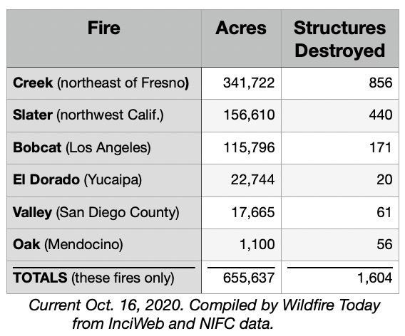
According to data compiled by Wildfire Today from InciWeb and the National Interagency Fire Center, the six fires in the aid request burned a total of 655,637 acres and destroyed at least 1,604 structures.

One of the six, the 341,722-acre Creek Fire northeast of Fresno, is the largest single fire in the state’s recorded history that was not part of a complex or the result of multiple fires burning together. It is still very active and grew for another 4,067 acres Thursday, producing large quantities of smoke affecting much of central California.

The other fires in the aid request were the Slater in northwest California, Bobcat near Los Angeles, El Dorado east of Yucaipa, Valley in San Diego County, and Oak near Mendocino.

From ABC News:

Federal Emergency Management Agency press secretary Lizzie Litzow told ABC News in a statement Friday that “the damage assessments FEMA conducted with state and local partners determined that the early September fires were not of such severity and magnitude to exceed the combined capabilities of the state, affected local governments, voluntary agencies and other responding federal agencies.”

FEMA, however, did approve four fire management assistance grants in five California counties for wildfires included in the state’s disaster request, according to Litzow.

“These grants will deliver millions of dollars of assistance for emergency expenses and funds to help reduce the risks of future disasters,” she said. .

Under the Fire Management Assistance Grant Program, FEMA provides assistance in the form of grants for equipment, supplies, and personnel costs for the mitigation, management, and control of any fire on public or private forest land.

Mr. Trump has threatened numerous times to stop sending federal money to California, including during a Cabinet meeting October 17, 2018:

So I say to the Governor, or whoever is going to be the Governor of California, better get your act together cause California we’re just not going to continue to pay the kind of money that we’re paying because of fires that should never be to the extent.

The President reaffirmed the issue November 10, 2018 in a tweet:

There is no reason for these massive, deadly and costly forest fires in California except that forest management is so poor. Billions of dollars are given each year, with so many lives lost, all because of gross mismanagement of the forests. Remedy now, or no more Fed payments!

Trump tweet Nov 10, 2018 forest fires california

On January 9, 2019 Mr. Trump again addressed the issue in a tweet:

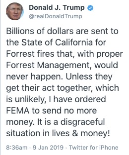
Billions of dollars are sent to the State of California for Forrest (sic) fires that, with proper Forrest (sic) management, would never happen. Unless they get their act together, which is unlikely, I have ordered FEMA to send no more money. It is a disgraceful situation in lives and money!

Trump President forrest
Tweet by President Trump which was deleted Jan. 9, 2019, then reposted with correct spellings.

According to a 2015 report by the Congressional Research Service the federal government manages 46 percent of the land in California. The California Department of Forestry and Fire Protection manages or has fire protection responsibility for about 30 percent.

Climate change is part of the equation that has resulted in longer fire seasons, extremes of heat and cold, drought in some areas, high fire danger, and dry fuels that are very receptive to rapid fire spread.

Creek fire burned gas station
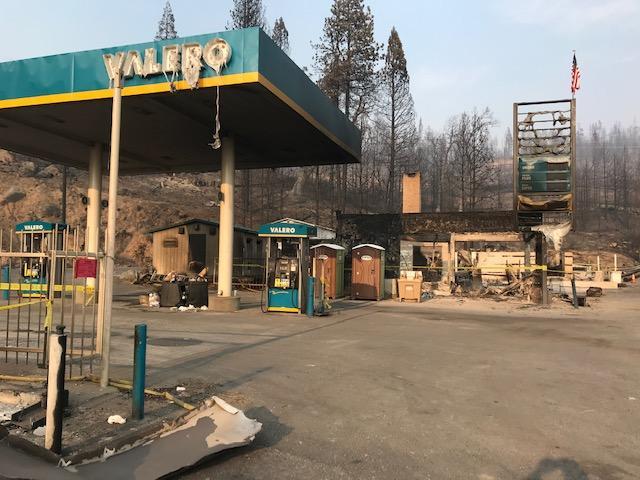
Gas station on the Creek Fire, photo by Daniel R. Patterson, PIO
national guard helicopters creek fire california
Helicopters from the California National Guard mobilized for the Creek Fire. Photo by Daniel R. Patterson, PIO.

Strong winds push Cameron Peak Fire east, prompting more evacuations

The 135,000-acre fire is west of Fort Collins, Colorado

Updated October 15, 2020   |   7:33 a.m. MDT

Map of the Cameron Peak Fire 3:06 a.m. MDT October 15, 2020
Map of the Cameron Peak Fire. The red line was the perimeter at 7:46 p.m. MDT October 13, 2020. The red dots represent heat detected by a satellite at 3:06 a.m. MDT October 15, 2020.

By mid-afternoon on Wednesday the very strong winds gusting to 50 mph that pushed the Cameron Peak Fire about 17 miles to the east toward Fort Collins slowed. A satellite showed very little spread east of Buckhorn Road which is about 6 miles west of Horsetooth Reservoir. Most of the additional acres Wednesday night were on the south side of the 17-mile run, northeast of Rocky Mountain National Park.

At 6:16 a.m. Thursday the Incident Management Team reported the fire had grown to 164,140 acres.

To see all articles on Wildfire Today about the Cameron Peak Fire including the most recent, click here.

Overnight a weather station at the CSU Mountain Campus recorded 5 mph winds out of the west gusting at 10 to 14 mph while the relative humidity remained low, in the low 20s, with a low temperature of 30 degrees.

A mapping flight scheduled for Wednesday night had to be cancelled due to clouds over the fire.

The weather forecast for Fort Collins calls for a shift in the wind, to come out of the east. This could reduce the smoke in the city and the threat to property between Buckhorn Road and Horsetooth Reservoir.


Updated October 14, 2020   |    10:36 p.m. MDT

Map Cameron Peak Fire, Oct. 14, 2020
Map of Cameron Peak Fire, afternoon of Oct. 14, 2020. Incident Management Team.

The Incident Management Team updated their map of the Cameron Peak Fire which was pushed by strong winds about 17 miles to the east Tuesday night and Wednesday. By mid-afternoon Wednesday it had reached Buckhorn Road about 6 miles west of Horsetooth Reservoir.

During the extreme growth of the fire structures burned, but until the intensity of the blaze decreases it could be days before the details will be available.

Now at 158,300 acres, it has become the largest fire in the recorded history of Colorado, surpassing the Pine Gulch Fire which blackened 139,007 acres north of Grand Junction a month ago.

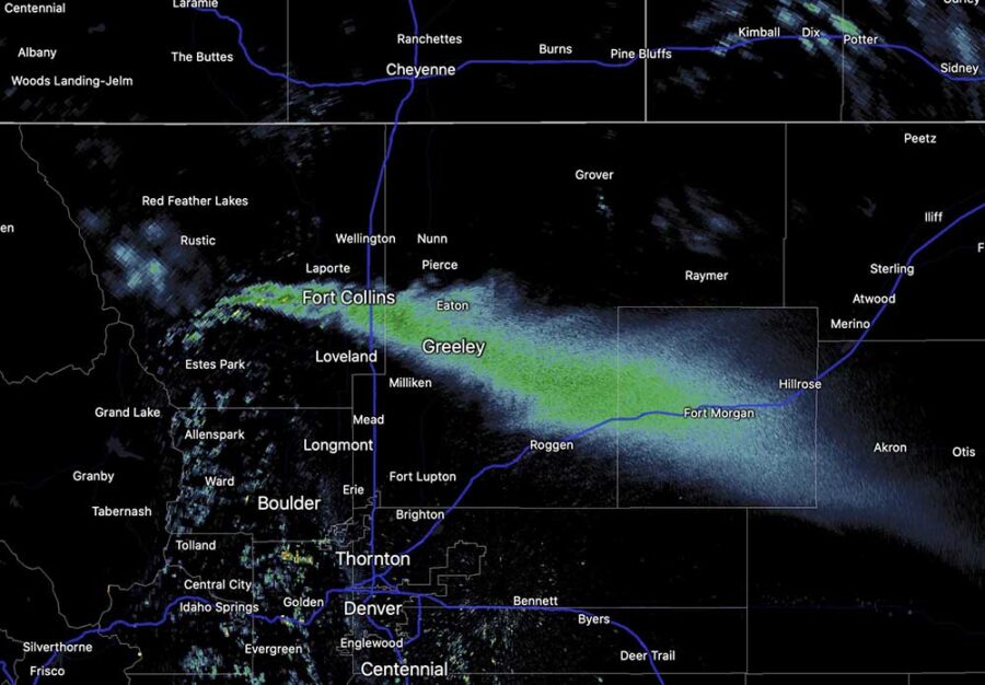
The huge pyrocumulus cloud that formed over the fire was creating rain 100 miles downstream from the smoke plume at 9 p.m. MDT Wednesday.

Cameron Fire pyrocumulus radar


Updated: October 14, 2020   |    4:18 p.m. MDT

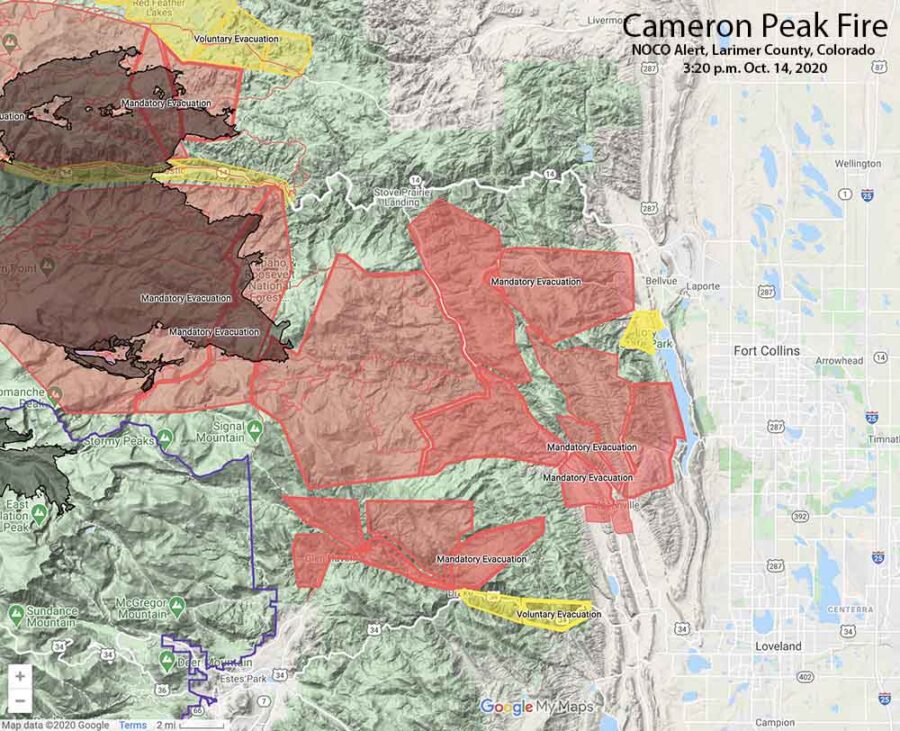
Map showing Cameron Peak evacuations 3:20 p.m. MDT, October 14, 2020
Map showing Cameron Peak evacuations at 3:20 p.m. MDT, October 14, 2020. Map by NOCO Alert, Larimer County.

The map above shows the mandatory evacuations have extended east to Horsetooth Reservoir.

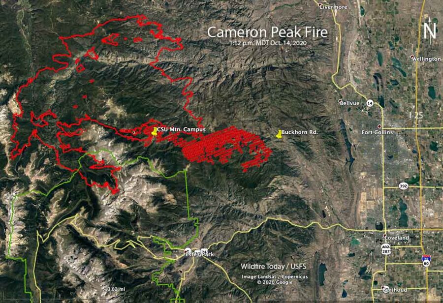
A satellite pass at 1:12 p.m. MDT Wednesday, below, shows the spread of the Cameron Peak Fire to the east. At that time is was 8 miles west of Horsetooth Reservoir.

Map of the Cameron Peak Fire
Map of the Cameron Peak Fire. The red line was the perimeter at 7:46 p.m. MDT October 13, 2020. The red dots represent heat detected by a satellite at 1:12 p.m. MDT October 14, 2020.

October 14, 2020   |    3:15 p.m. MDT

Cameron Peak Fire evacuations
Cameron Peak evacuations October 14, 2020. Map by NOCO Alert, Larimer County.

Very strong winds that began after sunset Tuesday caused the Cameron Peak Fire to become much more active. Mandatory and voluntary evacuations are in effect west of Fort Collins, Colorado (see the map above). This is a rapidly evolving situation.

To see all articles on Wildfire Today about the Cameron Peak Fire, including the most recent, click here.

Wednesday afternoon at about 2 p.m. the Larimer County Sheriff ordered the immediate mandatory evacuation of Redstone Canyon, advising, “Do not delay leaving to gather belongings or make efforts to protect your home or business. For updates, text the word LCEVAC to 888777 from your cell phone. We will communicate information to that key word as needed.”

The Larimer County webpage also has information about the Cameron Peak Fire. Evacuation information can be found at nocoalert.org.

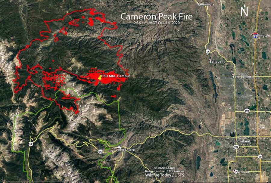
Cameron Peak Fire map
Map of the Cameron Peak Fire. The red line was the perimeter at 7:46 p.m. MDT October 13, 2020. The red dots and the solid red area represent heat detected by a satellite at 2:36 a.m. MDT October 14, 2020.

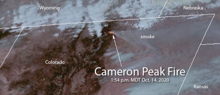
The Incident Management Team reported at 1 p.m. Wednesday that the fire was on top of Signal Mountain, and had spread approximately 10 miles east of the Colorado State University Mountain Campus (CSU). It was spreading to the east and east-southeast, in the general direction of Fort Collins. The smoke plume from the fire is massive and is being detected by radar and satellites.

Cameron Peak Fire radar smoke
Smoke from the Cameron Peak Fire shows up on radar at 1:55 p.m. MDT October 14, 2020.

Tuesday afternoon the weather station at the CSU Mountain Campus recorded 8 to 16 mph winds out of the west gusting at 20 to 38 mph. After sunset the speed increased throughout the night and into Wednesday afternoon blowing out of the west-southwest at 20 to 35 mph gusting at 33 to 50 mph, with a peak gust of 60 at 11:32 a.m. Wednesday. The relative humidity was in the low 20s all night and rose to the high 20s Wednesday afternoon with the temperature in the 30s.

Cameron Peak Fire satellite image
Satellite image showing heat and smoke from the Cameron Peak Fire at 1:54 p.m. MDT October 14, 2020.

Wetter conditions in Australia may lead to a fire season very different from a year ago

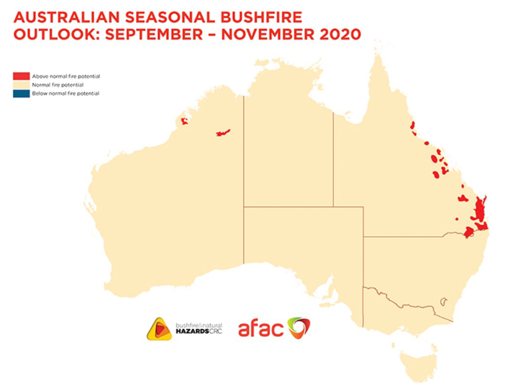
Australia fire outlook September through November, 2020

The 2020/21 fire season will be influenced by vastly different climate drivers than the previous two fire seasons, according to a September through November outlook from the Bushfire and Natural Hazard Cooperative Research Centre.

With a La Niña ALERT now active, large areas of eastern and northern Australia are expecting wetter than average conditions through spring. Despite the wetter climate signals, parts of Queensland face above normal fire potential in the south east and central coast, extending to the north.

While these wetter conditions in eastern Australia will help in the short-term, they may lead to an increase in the risk of fast running fires in grasslands and cropping areas over summer.

In contrast to the wetter conditions for the east, dry conditions persist in Western Australia, with above normal fire potential continuing to be expected in parts of the north.

Australia temperature outlook, October through December, 2020


Australia precipitation outlook October through December, 2020


Australia plans on having six large air tankers available during the 2020-2021 bushfire season.

California to face elevated wildfire danger again this week

Fire Weather Watch for Northern California and heat advisory for the southern part of the state

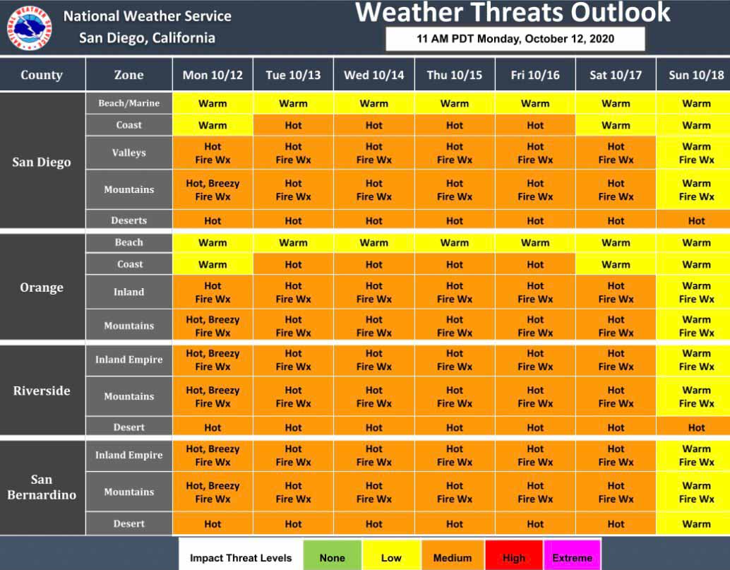
Southern California fire weather this week
Southern California fire weather this week. NWS.

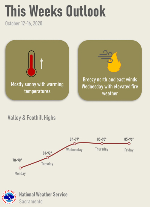
Firefighters in California could face another round of wildfires this week as the weather turns hot, dry, and windy in some locations.

In Southern California a heat advisory has been issued for Tuesday through Friday for highs in the lower elevations approaching 100 degrees.

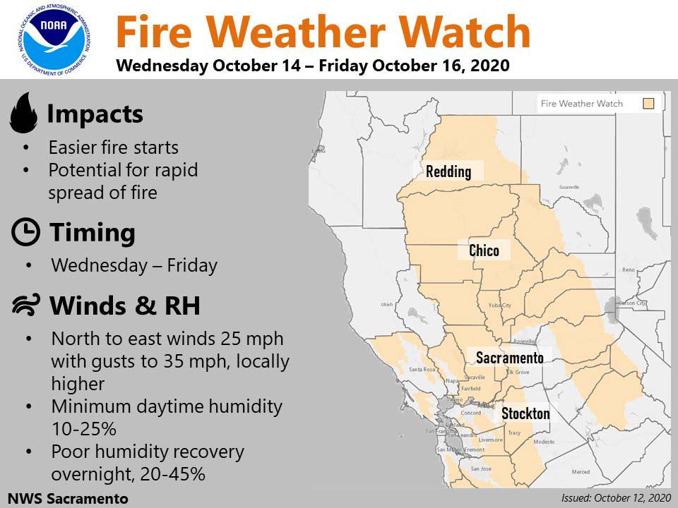
A Fire Weather Watch for Northern California is in effect Wednesday through Friday for breezy conditions, with the strongest winds expected Wednesday and Thursday.

There is a possibility of electrical power being preemptively being shut off by PG&E due to windy and dry conditions.

Possibility of electrical power being preemptively being shut off
Possibility of electrical power being preemptively being shut off this week by PG&E due to windy conditions.
Northern California fire weather this week
Northern California Fire Weather Watch this week.
Sacramento area fire weather this week
Sacramento area fire weather this week. NWS.