Witness panel is set for June 9 Congressional hearing about COVID-19 and firefighting

When the Senate Energy and Natural Resources Committee holds their hearing at 10 a.m. EDT June 9, 2020 on “Wildfire Management in the Midst of COVID-19” neither U.S. Forest Service Chief Vicki Christiansen or Fire and Aviation Director Shawna Legarza are slated to be present. Usually the Chief testifies at hearings about the Forest Service, and since Ms. Legarza testified last year at a hearing about expectations for the fire season, there was speculation that she would attend this one as well.

It is likely that the Senators will ask about the results from the Aerial Firefighting Use and Effectiveness Study that has been going on for eight years. Chief Christiansen has been testifying for the last two years before this committee saying it would be released “soon”. When pressed in February by Colorado Senator Cory Gardner, who last year made his opinion about the delay very clear, she said it would be released “this Spring.” Senator Gardner said, “Before June?” She said, “Yes.”

I asked Ms. Legarza by email why she was not going to testify, and she replied, “Normally the Fire Director does not testify. Last year was the first time ever. Was a great experience. I am very appreciative of all the work the committee has done while I have been in this job.”
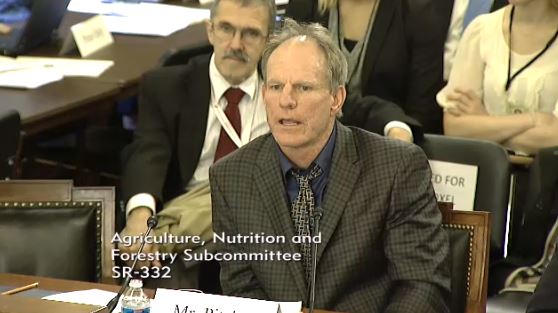
David Pitcher and Tom Harbour
Tom Harbour (left) the U.S. Forest Service National Director of Fire and Aviation Management (who did not testify), and David Pitcher (right) President and CEO of the Wolf Creek Ski Area at Pagosa Creek, Colorado. November 5, 2013.

A quick search of Wildfire Today found two examples of former Fire Director Tom Harbour attending congressional committee hearings. On October 17, 2011 he testified before a subcommittee of the House of Representatives’ Homeland Security committee at a field hearing in Austin entitled “Texas Wildfire Review: Did Bureaucracy Prevent a Timely Response?” On November 5, 2013 he sat directly behind the witnesses but did not testify at a hearing before the Senate Subcommittee on Conservation, Forestry and Natural Resources titled, “Shortchanging Our Forests: How Tight Budgets and Management Decisions Can Increase the Risk of Wildfire”.

I obtained from a Washington insider the list of government employees who ARE slated to testify Tuesday:

  • John Phipps, Forest Service, Deputy Chief, State and Private Forestry
  • Amanda Kaster, Acting Deputy Assistant Secretary for Land & Minerals, DOI
  • George Geissler, Washington State Forester
  • Norm McDonald, Alaska Div. of Forestry, Director Fire & Aviation

Some of the Senators and witnesses may appear virtually instead of in person. The current Senate rules during the pandemic do not allow spectators at committee meetings or hearings.


TBT: Firefighter’s film-making son invited to the White House

For Throwback Thursday I found a good news story — much needed during these turbulent times. Published March 21, 2015, it feels like it was a thousand years ago:


Noah Gue President Obama
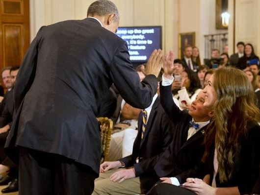
Noah Gue talks with President Obama in the White House. Photo credit, White House.

The six-year-old son of a wildland firefighter was one of 15 filmmakers to be invited to show a video at a film festival at the White House. Noah Gue worked with his father, Michael Gue, a firefighter with the U.S. Forest Service in Bozeman, Montana, to make the film to help raise awareness of climate change and inspire conservation. Noah’s parents produced the film in which he is the on-screen narrator. He also got a credit for editing. The film was selected to be shown Friday at the second White House Student Film Festival.

Noah Gue President Obama
Noah Gue high-fives President Obama in the White House. Photo by Jacquelyn Martin.
Noah Gue Hilary Swank
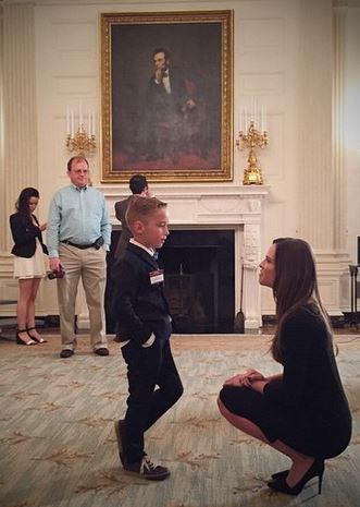
Noah Gue talks with Hilary Swank in the White House. Photo by Jake Rosenberg.

The fact that Noah had a loose front tooth did not escape the notice of President Obama who mentioned it in his opening remarks at the event. Here are some excerpts from the official transcript:

Thank you so much, everybody! Have a seat. Well, hello, everybody, and welcome to the second annual White House Film Festival. (Applause.) It’s like the Sundance or Cannes of film festivals that are open to the public through a government website. (Laughter.) It may also be the only film festival where one of the entrants has his tooth loose. (Laughter.) And may pull it out right here at the ceremony. (Laughter.)

[and later]

…Today, we’re celebrating a 6-year-old in Montana. Is that you? (Applause.) He’s the guy without — he’s missing teeth. (Laughter.) But he’s also challenging us to see conservation through a child’s eyes…

Noah’s father, Michael, is a prolific photographer, as is his wife who is a wedding photographer. We have featured Michael’s fire pictures a couple of times on Wildfire Today, HERE and HERE. His Instagram account has over 7,000 followers…

Congratulations to Noah and Michael!

Congress to hold hearing on “Wildfire Management in the Midst of COVID-19”

Save the date: June 9, 2020 at 10 am EDT, 7 am PDT

senate committee hearing fire four-person panel
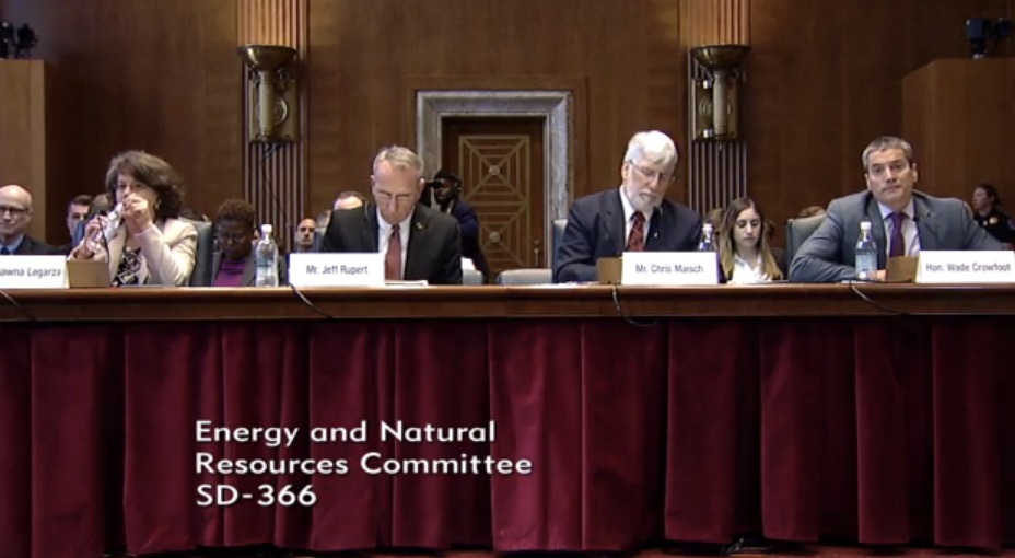
On June 13, 2019 a four-person panel provided testimony before the Senate Energy and Natural Resources Committee. L-R: Shawna Legarza, Director, Fire Aviation and Management, Forest Service; Jeff Rupert, Office of Wildland Fire, Department of the Interior; Chris Maisch, Alaska State Forester & National Association of State Foresters; and Wade Crowfoot, Secretary, California Natural Resources Agency. Screenshot from the Committee video.

The Senate Energy and Natural Resources Committee will hold a hearing at 10 a.m. EDT June 9, 2020 on “Wildfire Management in the Midst of COVID-19”. It will be webcast live on the committee’s website, and an archived video will be available shortly after the conclusion. Written witness testimony will be available on the website at the start of the hearing.

This could be very interesting, depending on what questions the Senators ask and if they follow up when the witnesses give vague or evasive answers. In 2019 Shawna Legarza, the Forest Service Fire and Aviation Director, was one of four on a panel. If she appears this year it will be with only 21 days remaining before her announced retirement date.

Shawna Legarza, Fire and Aviation Director, Forest Service
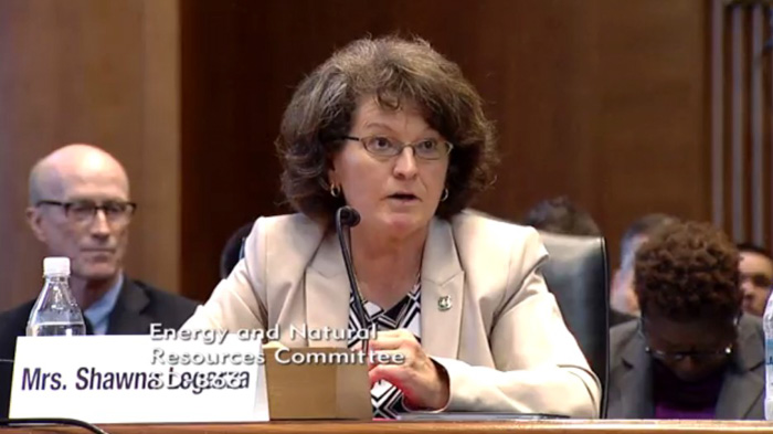
Shawna Legarza, Fire and Aviation Director, Forest Service, June 13, 2019 at a hearing before the Senate Energy and Natural Resources Committee. Screenshot from the Committee video.

This committee regularly holds hearings about the activities of the land management agencies, but also has hearings specifically about wildland fire topics. Senators sometimes press the Forest Service and the Department of the Interior agencies on topics such as the number of air tankers on contract, using technology to track fires and resources, transferring management of the Job Corps Civilian Conservation Centers from the FS to the Department of Labor, is the FS asking for enough funding to accomplish their goals, sexual harassment, and the outlook for the coming fire season.

Obviously this year the issue of fighting fire during the pandemic will come up. Another possible topic is accountability and lack of transparency for how decisions are made about contracting for firefighting aircraft and how taxpayers’ dollars are being used. Are they being spent wisely? When will they release the Aerial Firefighting Use and Effectiveness Study that has been going on for eight years? Launched in 2012 at a cost of about $1.3 million annually, the study is supposed to quantify the effectiveness of the various types of fixed and rotor wing aircraft used on wildfires. In FY 2017 for example, the most recent year with exact numbers available, the agency spent over half a billion dollars on fire aviation; $507,000,000. If ever completed the AFUE study could make it possible to answer the question: “What are the best mixes of aircraft to do any fire suppression job?” Data collected from this study and other sources would be used to inform decisions about the composition of the interagency wildland firefighting aircraft fleet — to use the best, most efficient, and effective tools for the job.

In hearings before the Senate Energy and Natural Resources Committee in 2018 and 2019 the Forest Service told the Senators the results of the study would be released “soon”. In another hearing in February, 2020 Forest Service Chief Vicki Christiansen again said it would be released “soon”. When pressed by Colorado Senator Sen. Cory Gardner, who last year made his opinion about the delay very clear, she said it would be released “this Spring”. Senator Gardner said, “Before June?”. She said, “Yes”.  A clip from that exchange is below.

Link to the entire hearing

(Members of the Energy and Natural Resources Committee)

(The list of members of the committee was replaced with the more current link above)

Evacuations ordered for Sawtooth Fire east of the Phoenix area

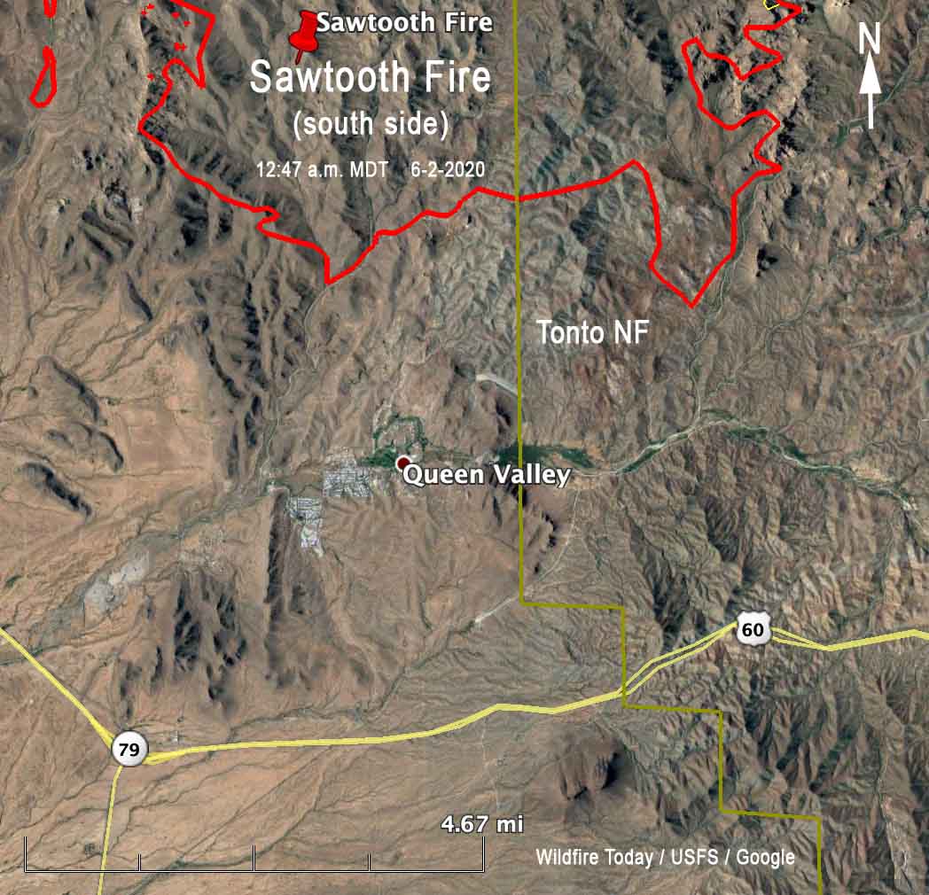
Affecting parts of Queen Valley — called “precautionary”, so firefighters can ignite back burns near the town

South side of the Sawtooth Fire map
Map of the south side of the Sawtooth Fire at 12:47 a.m. MDT June 2, 2020.

The incident management team for the Sawtooth Fire Tuesday morning announced the evacuation of part of Queen Valley. Firefighters expect to carry out a burnout operation nearby, also called back burn, in order to prevent the fire from spreading into the town.

Below is part of the announcement issued at about 11:30 a.m.:

Over the next few days, firefighters on the Sawtooth Fire will begin back burning operations as part of structure protection and community safety measures in and around the northeast portion of Queen Valley.  To ensure safety, starting at noon today, residents along Silver King Road and Williams Road in Queen Valley will be placed in precautionary GO status as they are being asked to vacate their homes while these suppression operations take place. At this time, this precautionary GO notification only effects those residents along those two roads. Currently, all other residents in Queen Valley and nearby communities are not impacted by this request and need not vacate their residence in support of these firefighting tactics.

For more information on the READY, SET, GO evacuation and preparedness program: https://ein.az.gov/ready-set-go.

To get notified about emergency alerts, including evacuation information, contact your local county emergency management office.

There is no estimated timeframe as to how long back burning operations will take within the northeast portion of Queen Valley. Residents are asked to be prepared to leave for a minimum of three days.

The news release included few details or links about how to find out more  about the evacuation, but we did some research:

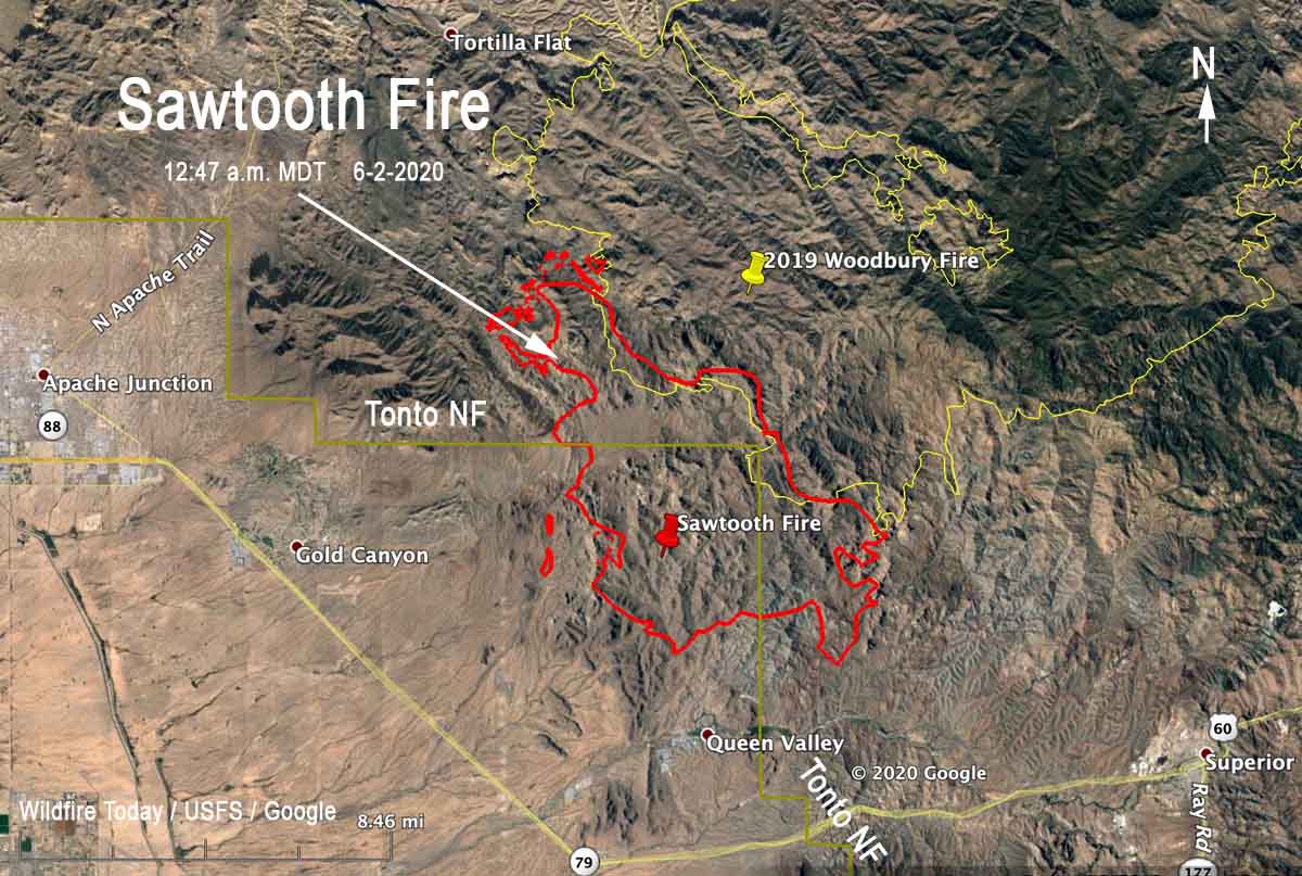
The Sawtooth Fire is east of the greater Phoenix area, 10 miles east of Apache Junction. At 12:47 a.m. Monday the south side of the fire was approximately 2 miles north of Queen Valley and 8 miles northwest of Superior.

(To see all articles about the Sawtooth Fire on Wildfire Today, including the most recent, click here)

If the incident management team releases an update on Tuesday they are expected to say it has burned over 20,000 acres.

Map Sawtooth Fire June 2, 2020
Map showing the perimeter of the Sawtooth Fire (in red) mapped by a fixed wing aircraft at 12:47 a.m. MDT June 2.

Wildfire potential expected to be above normal in many western locations this summer

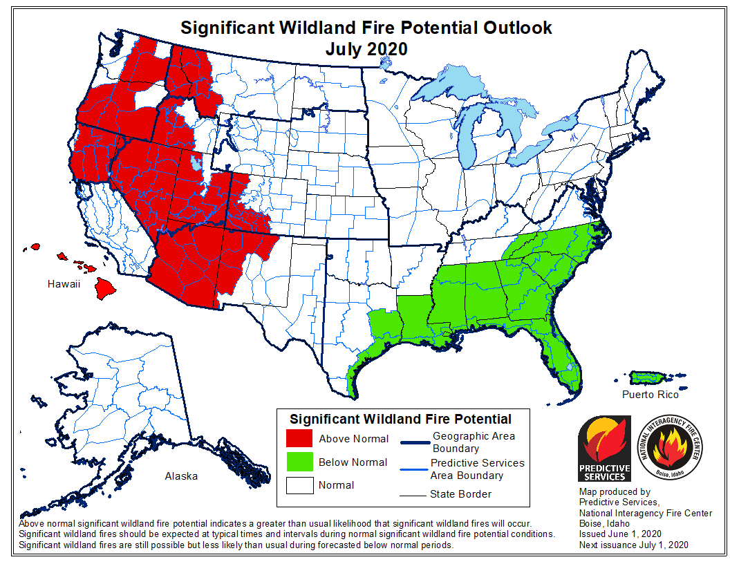
July could be a very busy month for wildland firefighters in the U.S.

potential wildfires fires weather forecast prediction

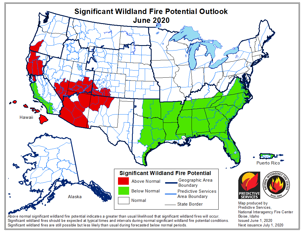
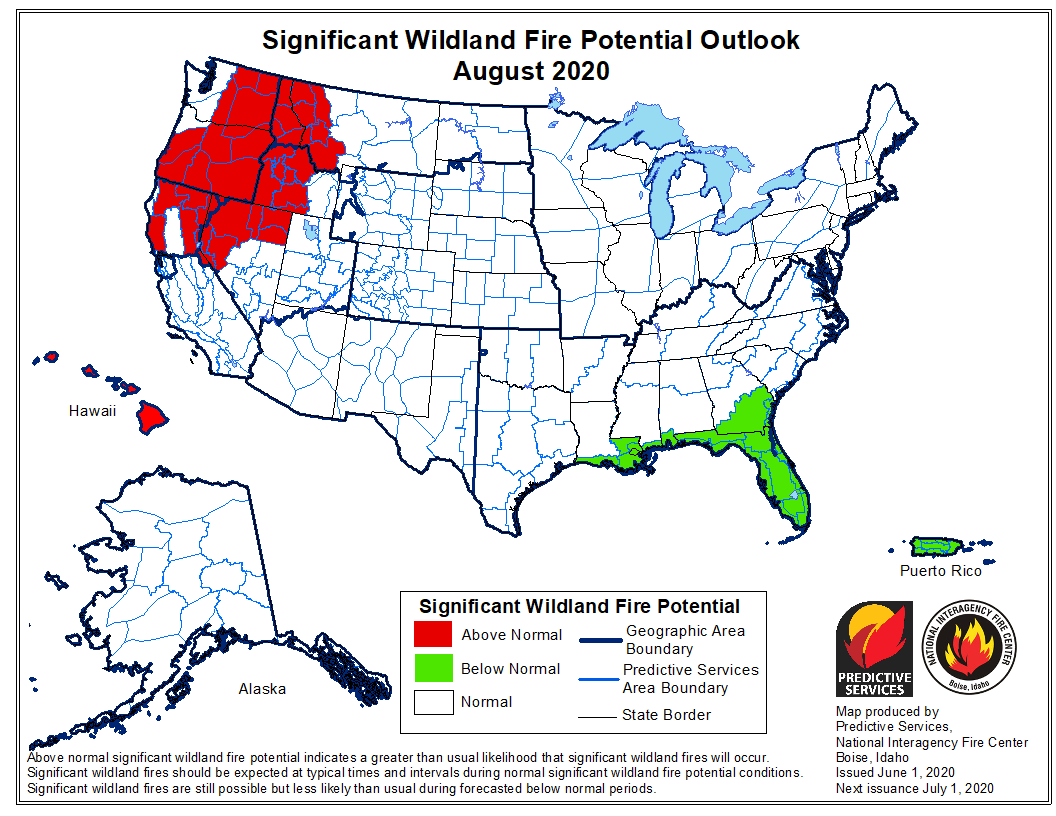
The National Significant Wildland Fire Potential Outlook issued today by the Predictive Services section at the National Interagency Fire Center for June through September indicates that many areas in the western United States will have above normal potential for wildfires. In July the increased fire danger is expected to affect significant portions of California, Washington, Oregon, Montana, Idaho, Nevada, Utah, Colorado, New Mexico, Hawaii, and Arizona.

The wildfire potential in the southern states is predicted to be below normal.

The data from NIFC shown here represents the cumulative forecasts of the ten Geographic Area Predictive Services Units and the National Predictive Services Unit.

Below:

  • An excerpt from the NIFC narrative report for the next several months;
  • More of NIFC’s monthly graphical outlooks;
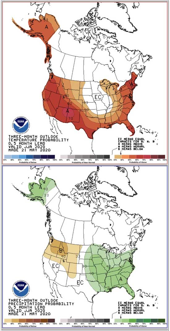
  • NOAA’s three-month temperature and precipitation forecasts;
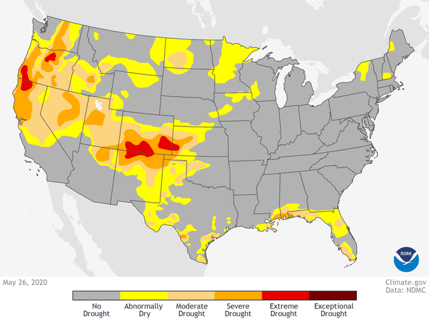
  • Drought Monitor;
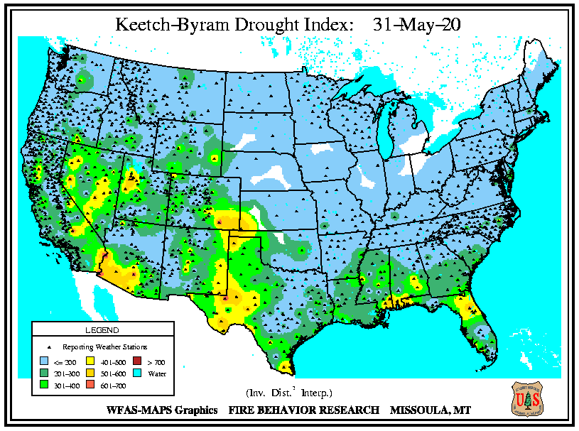
  • Keetch-Byram Drought Index.

“June through early July is the peak of the fire season across the Southwest. Expect for the normal fire activity across the region to increase through the period with some areas experiencing Above Normal significant large fire potential, especially across Arizona. As the monsoon begins in mid-July, activity across the Southwest will diminish. Activity across Alaska will also diminish as the rainy season begins. California, central and northern portions of the Great Basin, the Pacific Northwest, and the Northern Rockies will begin to enter their peaks.

“Above Normal significant large fire potential is expected in the areas shown on the maps due primarily to increasing drought conditions, early loss of mountain snowpack, anticipated lightning activity, and overall hot and dry conditions that should persist through August. As is typically the case, the peak season fire activity across the northwestern portion of the country should diminish by mid-September as the seasonal transition begins and allows for wet fronts to bring precipitation to impacted areas.”


potential wildfires fires weather forecast prediction

potential wildfires fires weather forecast prediction

potential wildfires fires weather forecast prediction

drought monitor
Drought Monitor
90 day temp precip
Forecast for temperature and precipitation, June through August, 2020. Made May 21, 2020.

IKeech-Byram Drought Index

Sawtooth Fire grows to over 20,000 acres

The fire is east of Phoenix, six miles east of Gold Canyon

(UPDATED at 8:02 a.m. MDT June 2, 2020)

Map Sawtooth Fire June 2, 2020
Map showing the perimeter of the Sawtooth Fire (in red) mapped by a fixed wing aircraft at 12:47 a.m. MDT June 2.

The Sawtooth Fire east of Phoenix 10 miles east of Apache Junction was not as active Monday as it was on Sunday. A fixed wing mapping flight at 12:47 a.m. MDT Tuesday determined that most of the growth was on the north side. When the incident management team releases an update Tuesday morning they are expected to say it has burned over 20,000 acres.

(To see all articles about the Sawtooth Fire on Wildfire Today, including the most recent, click here)

While firefighters faced 104 degrees Monday with 12 percent relative humidity, the wind was slight, about 2 to 5 mph which accounts for the less than massive spread Monday. The forecast for Tuesday calls for stronger winds out of the west at 5 to 10 mph, 13 to 18 percent RH, and a high temperature of 100 to 104. This could result in more fire activity than Monday on the south side of the fire north of Queen Valley and northwest of Superior.

At 12:47 a.m. Monday the Sawtooth Fire was approximately 2 miles north of Queen Valley and 8 miles northwest of Superior.


(UPDATED at 6:08 p.m. MDT June 1, 2020)

perimeter of the Sawtooth Fire map Arizona Phoenix
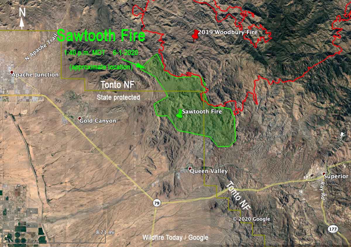
Map showing the approximate perimeter of the Sawtooth Fire (in green) based on heat detected by satellites at 1:40 p.m. MDT June 1.

The incident management team on the Sawtooth Fire updated the size at 6:50 p.m. today, saying it has burned 16,000 acres. A Type 1 incident management team has been ordered —  Sinclair’s team from the Southwest Geographic Area.

The updated map above shows the APPROXIMATE location of the Sawtooth Fire using satellite heat sensing data as of 1:40 p.m. Monday. The map includes the boundary of the Tonto National Forest (in yellow).

Most of the recent spread was on the northwest and south sides. It has grown about a mile closer to Queen Valley, and Monday at 2:30 p.m. was about two miles north of the community.

Very little official information is being released about this major wildfire.


(UPDATED at 8:20 a.m. MDT June 1, 2020)

perimeter of the Sawtooth Fire map Arizona Phoenix
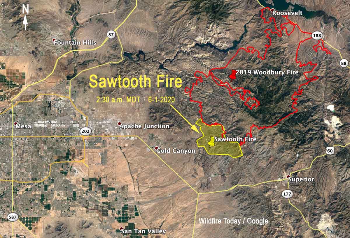
Map showing the approximate perimeter of the Sawtooth Fire (in yellow) based on heat detected by satellites at 2:30 a.m. MDT June 1. The fire is burning near the Woodbury Fire (in red) that blackened over 96,000 acres in June, 2019

The Sawtooth Fire east of Phoenix, Arizona was very active Sunday and Sunday night, spreading in all directions. It made a big push during the night growing three miles to the east and southeast.

(To see all articles about the Sawtooth Fire on Wildfire Today, including the most recent, click here)

During a satellite overflight at 2:30 a.m. MDT Monday the fire was six miles east of Gold Canyon, three miles north of Queen Valley, and seven miles northwest of Superior.

The lightning-caused fire was reported Saturday at 10 p.m. It has burned into the footprint of the Woodbury Fire that blackened over 123,000 acres in June, 2019. Sunday night the Forest Service reported that the Sawtooth Fire was 3,500 acres. According to heat detected by satellites at 2:30 a.m. Monday it was approximately 11,000 acres. There has been limited spread into the Woodbury Fire scar.

The Sawtooth Fire is on land protected by the state and is also within the Superstition Wilderness area of the Tonto National Forest.

Weather

The low relative humidity Sunday at Gold Canyon was 10 percent and the high temperature was 112, falling to 78 by 5 a.m. Monday. The wind Sunday was not extreme, blowing at 3 to 8 mph with occasional gusts to 15, and less than that during the night. The direction was generally from the southwest, but switched to come out of the west-northwest after 10 p.m. and later the northeast, which accounts for the spread of the fire to the south detected by the satellite at 2:30 a.m.

The weather forecast for the fire area on Monday predicts a high of 99 to 103 degrees, a minimum humidity of 12 to 17 percent, and 5 to 8 mph upslope winds in the afternoon with isolated gusts to 12. There’s no chance of rain.