US Army to adopt gender- and age-neutral fitness test

“We think the success of this study can transfer over to law enforcement, wildland firefighters, and other federal agencies,” said an instructor about a training program they have devised to prepare ROTC personnel for the Army test.

Some people have said that the Pack Test version of the Work Capacity Test required for many wildland firefighters in the United States does not adequately reflect the tasks performed on the job. Criticisms are that it has a bias toward individuals with long legs and does not sufficiently address flexibility, strength, speed, coordination, and agility. Others disagree, saying it can weed out those unfit for the job.

We created a poll on the subject:

The U.S. Army has developed a new Fitness Test that is reported to be gender- and age-neutral. To prepare and train their ROTC personnel for the test Colorado State University has designed a training regimen. Perhaps the federal land management agencies could glean some ideas from either the Army Fitness test or the training program being developed by CSU.

Below is an excerpt from an article on Colorado State University’s web site:


For more than 30 years, the U.S. Army has tested the strength and endurance of its soldiers through a battery of pushups, sit-ups and a two-mile run known as the Army Physical Fitness Test.

But soon the Army will replace this legacy test with a new gender- and age-neutral assessment consisting of six events — deadlifts, farmer’s carries, sled pulls and much more — that will impact personnel around the globe as well as right here at Colorado State University.

To prepare for the change coming in October 2020, CSU’s Army ROTC program is part of a pioneering study with the Department of Health and Exercise Science that examines the most effective training plans for the new Army Combat Fitness Test.

Lt. Col. Troy Thomas, commander of Army ROTC programs at CSU and the University of Northern Colorado, has personally endorsed the study and encouraged his cadre to pursue the most effective protocol for the 150 cadets, 28% of whom are female.

“On average, we have about seven contact hours per week with our cadets, and less than half of those hours are dedicated to physical fitness,” he said. “What we discover as the best protocol will elicit the most efficient and effective results of those three hours to achieve our scholar-athlete-leader outcomes.”

The research so far suggests hybrid training as the most effective option, and it has attracted attention and support from the U.S. Army and U.S. Department of Defense. According to the researchers involved in the study, it also could have a profound impact in helping U.S. Army Cadet Command prescribe fitness regimens to help ROTC cadets train for the new test.

“Colorado State is at the cutting edge of producing a combat fitness protocol for a very select population,” said Al Armonda, a CSU military science instructor who helped lead the study. “This falls well within our land-grant mission in filling a gap in the force that the Army needs.”

The new Army Combat Fitness Test consists of a series of six challenges designed to better connect certain fitness aspects with combat readiness such as strength, endurance, power, speed, agility, balance, flexibility, coordination and reaction time.

But for Army ROTC programs across the country, this presents a challenge.

An active-duty soldier can schedule four or five 70- to 90-minute training sessions in a typical week. For an ROTC cadet, Armonda said finding the time to properly train for the new fitness test can be difficult as they are first and foremost students.

In spring 2019, ROTC leadership and Armonda’s research team conducted a first-of-its-kind study comparing and contrasting several Army Combat Fitness Test training regimens.

The 10-week pilot study with 30 cadets showed strong evidence that a full-body, hybrid training approach — aerobic and anaerobic training, weight-lifting, body-weight exercises, plyometrics and high-intensity intervals — is far more effective than the traditional training regimens that focus solely on muscular endurance and aerobic exercise.

[…]

Department of Defense officials recently visited CSU to observe the training program and learn how they can provide support and assistance. Additional workout equipment, some of which has already been procured, is necessary as the new test requires deadlift bars, kettlebells and pullup stations. And researchers are currently launching a more robust study with 60 cadets for more statistical power.

Armonda said that the study has additional applications beyond the Army, noting that it can also be beneficial to first responders, many of whom start their careers in the U.S. military.

“Because of the constricted time frame that we have to actually complete these fitness requirements, we think the success of this study can transfer over to law enforcement, wildland firefighters and other federal agencies,” Armonda said…


Click here to see the entire article, including photos and videos.

Due to fire conditions NSW Premier says “Stay away from bush lands tomorrow”

Fire danger in New South Wales predicted for Nov. 12 is being described by officials as “horrendous” and “catastrophic”

UPDATED at 1:31 p.m. PST November 11, 2019


5:47 p.m. PST November 10, 2019

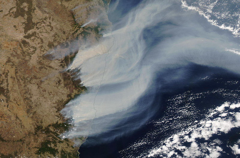
Satellite photo smoke bush fires New South Wales
Satellite photo shows smoke from bush fires in New South Wales. Processed by Dakota Smith (Approximate date Nov. 8, 2019)

New South Wales has been experiencing hot, dry weather for several days, resulting in numerous bushfires that have burned more than 100 homes. On Monday November 11 local time there were 65 active fires in NSW with about half of those being uncontained, while 10 have risen to the “Watch and Act” alert level.

“We are in uncharted territory,” said NSW Rural Fire Service Commissioner Shane Fitzsimmons. “We have never seen this many fires concurrently at emergency warning level.”

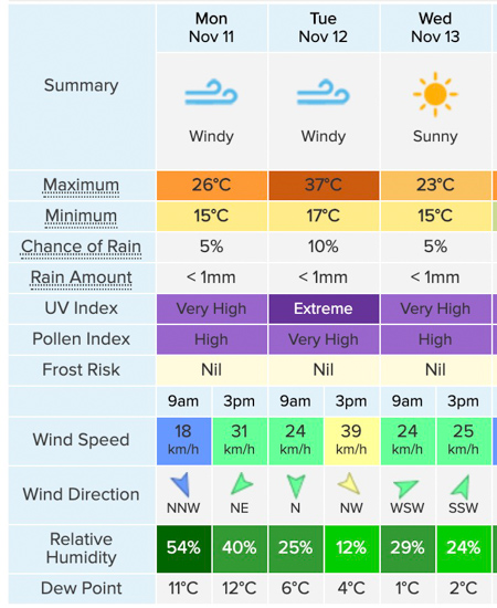
Weather forecast for Sydney, NSW
Weather forecast for Sydney, NSW, created Nov. 11, 2019 local time. Weatherzone. On Tuesday at 3 pm:  98F degrees, 24 mph winds, and relative humidity in the low teens.

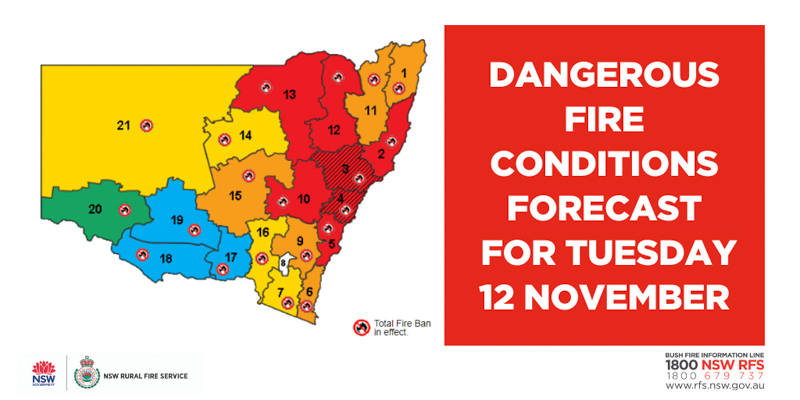
Conditions are going to get even worse. The weather forecast for Tuesday, November 12 predicts fire danger that according to the NSW Rural Fire Service will be at the “catastrophic” level. Residents in some areas are being advised to evacuate before the extreme conditions hit even if there are no fires nearby.

On January 8, 2013 the bush fire danger in NSW ranged from Severe to Catastrophic, and  reached the Catastrophic level in Queensland November 28, 2018.

Many of the currently active fires are across the north coast and northern NSW areas and will not be contained by the time the extreme fire weather strikes on Tuesday. Under these conditions, the fires will spread quickly, threatening homes and lives. The fire danger will be as bad, if not worse, than that experienced on Friday as it will be across a much broader area including large population centers like Sydney.

New South Wales bushfire danger November 12, 2019
New South Wales bushfire danger for November 12, 2019. NSW RFS.

At a Monday press conference Premier Gladys Berejiklian said, “Stay away from bush lands tomorrow”. Due to the dangerous fire risk and extreme conditions she said she had declared a state of emergency. It is the first state of emergency in NSW since October, 2013, when major bushfires swept the state during similar weather conditions.

Rural Fire Service Commissioner Shane Fitzsimmons
Rural Fire Service Commissioner Shane Fitzsimmons at the Monday press conference.

“Tomorrow we are facing horrendous conditions, life is at risk when it comes to catastrophic conditions,” said Rural Fire Service Commissioner Shane Fitzsimmons at the press conference. “We cannot guarantee a fire truck at every home. We cannot guarantee an aircraft will be overhead when a fire is impacting on your property. We cannot guarantee that someone will knock on your door and give you a warning that there’s fires nearby. And we certainly cannot guarantee that despite our best efforts the technological tools available will deliver you a message in time.

“We know the fires on the north coast are not going to be contained ahead of [Tuesday’s] weather which means those fires are going to spread, they are going to spread quickly, and they are going to spread aggressively,” the Commissioner continued. “The risk is real to pretty much any community in or around the proximity of all those fires burning on the north areas of New South Wales particularly given the forecast of hot temperatures and dry winds dominating out of the west or northwesterly areas. You can pretty much guarantee anybody to the east or southeast as a predominant pattern will certainly be at risk from the fires on the north coast tomorrow.”

100 homes destroyed in New South Wales bush fires

Above: The Suomi Joint Polar Satellite System captured this photo of smoke from bush fires in New South Wales, Australia, November 8, 2019. The red areas represent heat.

Large, rapidly spreading bushfires that swept through areas in Australia Friday are being described as “unprecedented”. Saturday morning, local time, the New South Wales Rural Fire Service  (NSW RFS) said at least 100 homes have recently burned in 42 fires that are still uncontained across the state. More than 30 people have been injured.

Saturday morning the NWS RFS said, “Fire activity has eased across some firegrounds. Nine fires are now at Emergency Warning and nine are at Watch and Act. We are still seeing erratic and dangerous fire behaviour across the remainder of fire grounds, which continues to pose a threat to homes.”

Queensland is also experiencing fires. Evacuation notices were issued Friday night for Lower Beechmont in the Gold Coast hinterland, Noosa North, and Thornton, west of Brisbane.

One year ago today — the Woolsey Fire

The fire destroyed over 1,600 structures and burned nearly 97,000 acres north of Malibu, California

Above: A CL-415 super scooper air tanker drops water on the second day of the Woolsey Fire, November 9, 2019. stonebrookphotography

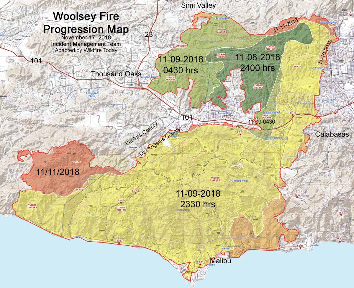
When the Woolsey Fire started at about 2 p.m. on November 8, 2018 the humidity was five percent and the wind was gusting out of the north and northeast at 40 to 50 mph. At 5:15 the next morning it jumped the 12-lane 101 freeway and before noon ran for another six miles to the Pacific Ocean, a distance of about 15 miles from the point where it started 22 hours before.

It ignited in Woolsey Canyon on the Santa Susana Field Laboratory property, a complex of industrial facilities owned by Boeing above the Simi Valley near the Los Angeles/Ventura county line in southern California.

Two other major fires had already started earlier that day, drawing some of the firefighting resources that could have been used on the Woolsey Fire. The Camp Fire started early that morning wiping out much of Paradise in northern California before noon. Then the Hill Fire ignited at about 1 p.m. south of Thousand Oaks 13 miles southwest of where the Woolsey Fire began an hour later. The Hill Fire eventually burned over 4,500 acres and required the evacuation of 17,000 residents.

An After Action Review released in October by Los Angeles County listed some of the issues that affected the management and suppression of the Woolsey Fire that destroyed over 1,600 structures and burned nearly 97,000 acres.

Progression map Woolsey Fire
Progression map of the Woolsey Fire, November 17, 2018. Perimeters produced by the Incident Management Team. Adapted by Wildfire Today.

Opinion: Staffed lookout towers are an effective tool for firefighters

Above: The new 40-foot fire lookout tower at Big Pocono State Park in Monroe County, PA is one of 16 that are replacing old towers. Penn. Dept. of Conservation and Natural Resources photo.

By Michael Guerin

Even in our technologically advanced age, most reports of fires are called in by observant folks, often using cellphones. The ubiquity of these devices means an increased ability to detect wildfire more quickly. But a fair portion of California still has poor or no cellular coverage. Utilities that shut down power as a wildfire-prevention measure in fire-danger zones also render cellphones in many areas unusable as cell towers lose power.

And as crowded as California can seem, large areas of the state are relatively unpopulated, not dense with residents or hikers who might quickly report a fire. Yet a key firefighting tool that existed in the pre-cellphone era is missing — watchers who were paid to scan the horizon for fires.

At one point, there were more than 9,000 lookout towers in the United States, placed atop hills and mountains where individuals — also referred to as lookouts — worked alone each summer to watch for and report fires. They were adept at recognizing a tiny puff of color against the backdrop of trees, hills or brush for what it can be — the start of what may be the next big fire. An estimated 500 are still staffed across the nation.

California once had about 600 such towers, under federal, state and local control, scattered around forest and wildland ridges and high points, placed specifically for the broad field of view each site afforded. In the Angeles National Forest and surrounding county wildland areas, 24 lookouts watched for our safety.

The state alone employed watchers in as many as 77 towers at one time. The California Department of Forestry and Fire Protection now operates 38 towers, and they are only staffed by employees on occasion. None of these is in Southern California.

In the 1970s and 1980s, there was a growing belief that air pollution had decreased visibility at some sites, and the creep of suburbia and population into the hills and valleys made these watchers seem less necessary. Then there were the cost savings, however modest.

To help address California’s 2003 budget shortfall, the agency that became CAL FIRE offered up the remaining state lookout staffing for a whopping saving of $750,000. By then most towers in the southern national forests and those operated locally by counties or CAL FIRE were gone, repurposed or used as museum pieces.

Today, the U.S. Forest Service mainly hires lookouts for towers in its far northern forests.

Enter the volunteers, including me. Each summer day we staff 11 towers in the Angeles, Cleveland and San Bernardino national forests. Volunteers also watch from at least 16 Forest Service and CAL FIRE towers in Central and Northern California.

We spend thousands of hours each fire season watching over the wildland — and the wildland-urban interface in which many of us live. We constantly scan the landscape with binoculars, watchful humans in constant touch with the dispatcher who can immediately send in the firefighting cavalry. As I scan for “smokes” I often gaze at the peaks that used to have staffed towers, and calculate how much more land we watchers could help protect.

Given our increasingly devastating fire seasons in California, the state should consider reintroducing a wider system of lookout towers, staffed by both paid personnel and volunteers. While budgets may be stretched, staffing an existing tower is not prohibitively expensive.

U.S. Forest Service seasonal lookouts make about $16,000 per summer. By comparison, the valuable Boeing 747 Air Tanker often seen dropping water and fire-retardant substances on California’s devastating fires costs $16,500 an hour to operate.

Many states have ended their lookout programs, but Pennsylvania decided to refurbish its lookout towers and invest in new ones. The state recently built 16 new towers for $6 million, each to be staffed during periods of high danger.

Other detection technologies such as satellite and automated camera systems that might sense a smoke plume could be vital in detecting these seemingly endless fires. But the technology is not infallible.

For instance, the fire-detection camera that may have been closest to the origin of last year’s deadly and destructive Camp Fire in Northern California’s Butte County might have been able to provide an early alert, but its alarm had been turned off as a result of many false alarms, according to news reports.

Few first reports of fires come from cameras, a CAL FIRE spokesman said. They are most often used to monitor fires already reported. Volunteers from the Forest Fire Lookout Assn. are working with researchers to refine these capabilities, and California Gov. Gavin Newsom has allocated $1.6 million for a prototype system for satellite-based detection.

Lookouts and their towers should not be regarded as a sentimental anachronism. They are a critical tool awaiting California’s renewed investment — and might help reduce the state’s fire-suppression costs, which reached $635 million during the 2018-19 fiscal year.

Automation may get to a point where it can more easily detect small fires, but it is not there yet. We still need to rely on old-fashioned human lookouts who are trained to “catch them small.”


Michael Guerin had a 38-year career in public safety and emergency management. While never a firefighter, he worked for the California Office of Emergency Services for 15 years, advancing to the post of Assistant Director for Emergency Operations, Plans and Training. For the past several years he has been a volunteer fire Lookout with the San Bernardino National Forest, helping staff the Red Mountain tower in Riverside County.

The article is used here with Mr. Guerin’s permission. It first appeared in the Los Angeles Times.

Firefighters gaining containment on the Ranch Fire

The fire has burned 2,534 acres 21 miles southwest of Red Bluff, Calif.

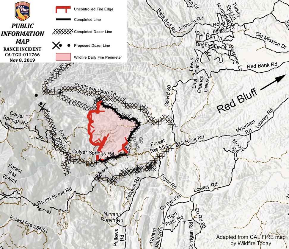
Map of the Ranch Fire November 8, 2019
Map of the Ranch Fire November 8, 2019. CAL FIRE map cropped by Wildfire Today.

10:58 a.m. PST November 8, 2019

Firefighters working on the Ranch Fire have completed a control line around almost half of the perimeter (see map above). Satellites have not detected very many large sources of heat on the western three-quarters of the incident for a couple of days.

The fire is 21 miles southwest of Red Bluff, California and one mile east of the Mendocino National Forest.

Evacuations are still in effect along Colyear Springs Road from Red Bank Road to the Mendocino National Forest Boundary.

CAL FIRE reports that the fire has burned 2,534 acres, which is a reduction from 3,768 acres due to more accurate mapping.

(To see all of the articles on Wildfire Today about the Ranch Fire, including the most recent, click here.)

Resources assigned to the fire include 65 fire engines, 10 water tenders, 36 hand crews, 5 helicopters, and 13 dozers for a total of 1,123 personnel.