The Tyee Ridge Complex consists of 19 fires ignited by lightning on the evening of August 24. About 200 people have been evacuated.
As of August 29, the fires had burned 2,899 acres in the hills around the community of Umpqua, approximately 10 miles west of Sutherlin. According to a report by KPIC-TV, the fires are under unified command with the Oregon Department of Forestry (ODF) Team 1 and the Oregon State Fire Marshal’s Red Team. The fires are in rugged, steep, and difficult terrain, but crews are making progress and the fire is now estimated at 5 percent containment.
Firefighters have been working since Tuesday night with very active fire behavior on the Cougar Creek and Lighthouse fires. Active fire behavior is predicted till cooler conditions and expected showers arrive.
On Wednesday firefighters worked on a number of spot fires that Had crossed containment lines.
Water and retardant drops are supporting ground crews in areas of steep or inaccessible terrain. Single-engine airtankers and helicopters worked closely with heavy equipment operators and hand crews. Among the aircraft were two Chinook CH-47 helicopters from the Oregon Army National Guard.
To the north, the Big Tom Fire saw more active fire, while there was increased mop-up on the Hardscrabble, Blue Hole, and Yellow Point fires, all moving toward patrol status in coming days, according to a KPIC report.
Oregon State Fire Marshal task forces worked around structures, installing sprinkler kits along Hubbard Creek, Briarwood Road, and the Lighthouse community. They are integrated with ODF crews to HELP in cutting line and protecting homes.
Fuel moistures are well below average for this time of year. There is a heavy dead and down component to the fire area, with fuels burning actively and intensely. Even though humidity recoveries are good to excellent overnight and moderate during the day, heavier fuels are slow to respond. The steep terrain is also a factor in fire behavior that accelerates upslope fire runs, torching, and potential for spotting.
Currently the evacuations are: Level 3 (Go) from the 11000 block of Hubbard Creek Rd. to Millwood Dr., Level 2 (Set) from Hubbard Creek Rd. from Millwood Dr. to Melqua Rd., and Level 1 (Ready) for Tyee Road at the intersection with Rock Creek Rd. to Fanchin Lane. Closures: Hubbard Creek Road at Millwood Drive.
Several major insurance companies have stopped accepting California homeowners for new policies because of growing wildfire risks. As the number of fires in the state increases and other factors escalate, insurance companies worry about the risk — and the expense.
In 2022 there were over 5,000 wildfires, according to Cal Fire, that burned about 118,000 acres. Already this year 4,337 fires have burned over 114,560 acres.
Residents in high-risk fire areas or hurricane regions need homeowners’ insurance — and lenders require it. No insurance, no home loan. More people are moving into the interface, costing insurance companies too much to repair and replace houses while battling inflation, said Janet Ruiz with the Insurance Information Institute. Two insurance giants withdrew from California’s home insurance marketplace, explaining that increasing wildfire risk and soaring construction costs have resulted in their decisions to stop writing new policies in the state. State Farm announced last week it would stop accepting applications for all business and personal lines of property and casualty insurance, according to the Associated Press. The company cited inflation, a challenging reinsurance market, and rapidly growing catastrophe exposure.
“We take seriously our responsibility to manage risk,” State Farm said. “It’s necessary to take these actions now to improve the company’s financial strength.”
Unlike heavyweights State Farm and Allstate, which declined to sign new homeowners in the state, AmGUARD and Falls Lake will also drop their existing policyholders.
Allstate, another insurance powerhouse, announced in November it would pause new policies for homeowners, condos and commercial properties in California to protect current customers.
Homeowners may have to turn to the California FAIR Plan, which provides basic fire coverage, if they aren’t able to find an insurer that will cover fire expenses. The high-risk pool known as the FAIR Plan is not a government entity or a state program. Taxpayers do not fund the FAIR Plan — it’s supported by all carriers licensed to do business in California, which spreads the risk among all the insurance carriers. Because the FAIR Plan is a high-risk policy, people should expect to pay more than they would for a standard homeowner policy.
The San Francisco Standard reported last week that two more companies quietly left the California market, further narrowing options for those trying to insure their home or purchase one with a mortgage.
AmGUARD Insurance — a subsidiary of Berkshire Hathaway GUARD Insurance Companies — will withdraw its homeowners and personal umbrella programs, and Falls Lake Insurance will also end its homeowners program. Both companies made the announcements July 21 in little-noticed filings submitted to the state regulator. AmGUARD and Falls Lake are the latest insurers to end or limit their business in the state during the past year.
Unlike heavyweights State Farm and Allstate, which declined to sign new homeowners in the state, AmGUARD and Falls Lake will also drop their existing policyholders. Safeco plans to drop 950 policies in October in San Francisco and the East Bay.
An SFGATE report noted that State Farm held the most policies in the California property market in 2021, and the company experienced about a 60 percent loss that year.
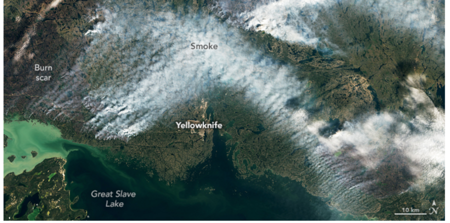
Hundreds of wildfires burning in Canada’s Northwest Territories have resulted in emergency declarations and the evacuation of the capital city of Yellowknife — by road and by air. About 20,000 residents of Yellowknife have been ordered to leave, as more than 230 fires burn across the territory and smoke drifts south into the United States. CNN reported that Yellowknife accounts for about half of the total population of the remote territory, located north of Alberta and east of Yukon.
The BBC reported that thousands of people on the outskirts of Yellowknife, one of the largest cities in Canada’s north, have crowded into the local airport and choked the road out of town. Hundreds have lined up for emergency military evacuation flights, and officials have given Yellowknife residents a deadline of noon Friday to leave.
NASA image of NWT smoke August 16, 2023
“We’re all tired of the word unprecedented,” said Premier Caroline Cochrane.
This afternoon the fire had burned to within 16km (10 miles) of the city. “Very tough days ahead,” said the territorial fire service, predicting more high winds. The closest evacuation shelter is 1,100km south of Yellowknife.
Military evacuation flights were scheduled today, with five flights to Calgary in the neighboring province of Alberta. The federal transport minister said Air Canada is capping the cost of flights out of Yellowknife and has added two extra flights out of the city.
One of the fires west of Yellowknife is at 165,000 hectares — over 407,000 acres. “We’re all tired of the word unprecedented,” said Premier Caroline Cochrane. “Yet there is no other way to describe this situation in the Northwest Territories.”
Shares of Hawaiian Electric fell more than 20 percent today after reports that the utility is considering restructuring as it faces numerous high-end lawsuits for its role in Maui’s disastrous wildfires. The company’s stock is down more than 73 percent thus far in 2023.
According to a CNN report, shares plummeted to 13-year lows on Monday after a class-action suit alleged that the Maui fires were caused by powerlines toppeled by strong winds. In a lawsuit strikingly similar to the Pacific Power class-action suit in Oregon, plaintiffs want the power company to bear financial responsibility for the deaths and destruction resulting from the utility’s failure to de-energize its powerlines despite ample warning by fire officials and weather experts about approaching extreme winds and related volatile dangers.
“The past days have been devastating for Maui and all of Hawaii,” said Shelee Kimura, president and CEO of Hawaiian Electric. “We have seen human loss and devastation on a scale that’s difficult for our hearts and minds to process. Maui lost homes and businesses, places of worship and cherished historic places. My heart breaks over and over, alongside all of Hawaii, for the people, communities and aina of Maui.”
She added that the restoration efforts now under way are personal to the utility’s employees. “Hawaiian Electric will continue to be here in full force with hundreds of dedicated employees and partners from Maui, Oahu, Hawaii Island, Molokai, Lanai, and beyond. We are focused on restoring power to support our communities’ work to recover and build back.”
The lawsuit alleges that Hawaiian Electric Industries “chose not to deenergize their powerlines during the High Wind Watch and Red Flag Warning conditions for Maui before the Lahaina Fire started,” despite knowing the risks of igniting a fire in those conditions. At least two other lawsuits have already been filed against the company for its role in the fires that killed at least 111 people on the island and destroyed the town of Lahaina. That number is expected to rise, with as many as 1,000 people still missing.
The Lookout Fire just north of McKenzie Bridge had burned 2,720 acres by Tuesday and was at zero percent containment. At an online briefing, Northwest Team 6 IC Tyson Albrecht said they are working with crews and aircraft to build line along a logging road. As of August 16, the fire was at 3,710 acres. KEZI-TV reported that the small mountain communities along the McKenzie River are struggling with more of the Lookout Fire’s smoke drifting across the region.
Lookout Fire at night August 13, inciweb photo
Smoke grounded aircraft yesterday and hotshots and structural strike teams from out of the area worked on protecting houses and powerlines. Doug Epperson with IMT 6 said they’re trying to keep the highway open for as long as possible.
“They started last night with some back burning that will continue today to remove fuels between where the fire is,” Epperson said. “We are doing everything so we can keep that highway open … our goal is to not have to close it.”
Around 400 personnel are working on the fire, with another 60 to 80 personnel joining each day.
Smoke visible from Tokatee Golf Course on August 13, inciweb photo
The fire grew quickly on Sunday, according to an OPB report, and prompted evacuations for residents north of Highway 126 near McKenzie Bridge.
There is a Red Cross shelter at Lowell High School; the IMT has scheduled a community meeting Thursday at 6:30 p.m. at McKenzie High School in Vida.
Also east of Eugene, the Bedrock Fire on Monday was shaded by heavy smoke, lowering temperatures slightly and moderating fire behavior. Helicopters on the Bedrock were also grounded.
The Bedrock Fire is at 26,154 acres with about 20 percent containment. Crews have been holding the fire within containment lines on the northern, eastern, and southern portions of the fire, which has nearly 1100 personnel assigned. The Oregon State Fire Marshal’s Office has assigned 8 task forces for interface structural protection, and OSFM resources were joined by a California Office of Emergency Services (Cal-OES) task force yesterday. They’re doing surface prep, structure triage, and overnight patrols. Crews also worked on sprinkler installations and vegetation clearing on the HJ Andrews Experimental Forest compound.
Evacuation Centers: There is an evacuation center for people and small pets at Lowell High School for evacuees from both the Bedrock and Lookout fires. A large animal shelter is setting up at the Lane County Fairgrounds in Eugene.
There is a current Level 3 (GO!) evacuation ordered for:
Taylor Road
North Bank Road
Areas north of Hwy 126 between Blue River Reservoir Road and Drury Lane
Mona Campground
Lookout Campground
HJ Andrews Experimental Forest headquarters
Firefighters are building line along the western edge of the fire, clearing and improving roads, and putting in dozer line. KPIC-TV reported that on Tuesday, firefighters were defending homes in Big Fall Creek.
Sawyer on the Bedrock Fire, inciweb photo
The fire started near Bedrock Campground on the Middle Fork Ranger District of the Willamette NF on July 22. Unusually dry fuels, steep slopes, and gusty winds contributed to rapid fire growth.
Northwest IMT 13 assumed management on July 25. On August 6, Northwest IMT 12 transitioned in, then on August 7 the IMT 12 also took over management of the Salmon Fire near Oakridge.
Oregon fires 0816
The IMT has scheduled a community meeting for the Bedrock and Salmon Fires tomorrow, August 17 at 7:30 p.m. at the Pleasant Hill School Community Center.
Firefighters on a tactical firing operation at night. Inciweb photo. They are watching for spot fires across the fireline.
The Salmon Fire is just 135 acres and about 80 percent contained. Firefighters are patrolling the perimeter and the incident’s recently shown minimal fire behavior. Resources include 3 engines, 1 crew, 1 watertender, and aircraft shared from the Bedrock Fire.
UPDATE — ROAD CLOSURE: Meanwhile, part of Hwy 199 south of Cave Junction is closed; CALTRANS has closed U.S. 199 at the Oregon-California border.
Hwy 199 closure south of Cave Junction. Check for updates at tripcheck.com
According to Oregon DOT, the closure is in response to wildfire activity in the area, and the estimated duration of the closure is unknown. No local detours are available.
The Head Fire on the Klamath National Forest is one of a couple dozen in the area recently ignited by lightning. “This has been a fire that has moved extremely quickly,” Forest Supervisor Rachel Smith told The Associated Press. “Just in a matter of a couple of minutes yesterday afternoon the fire grew from just 50 acres to nearly 1,500 acres.”
Direction Impacted: Both Comments: Lone Mountain Rd is CLOSED to all but local traffic from US 199 to the California border because of a wildfire in the area. Do not use Lone Mountain Rd as a detour for the US 199 closure.
Agency: Josephine County Public Contact: Brent Atkinson (503) 986-3977


 “The past days have been devastating for Maui and all of Hawaii,” said Shelee Kimura, president and CEO of Hawaiian Electric. “We have seen human loss and devastation on a scale that’s difficult for our hearts and minds to process. Maui lost homes and businesses, places of worship and cherished historic places. My heart breaks over and over, alongside all of Hawaii, for the people, communities and aina of Maui.”


