Analysis of wildfire danger during the California wind event using Hot-Dry-Windy Index

Hot-Dry-Windy Index
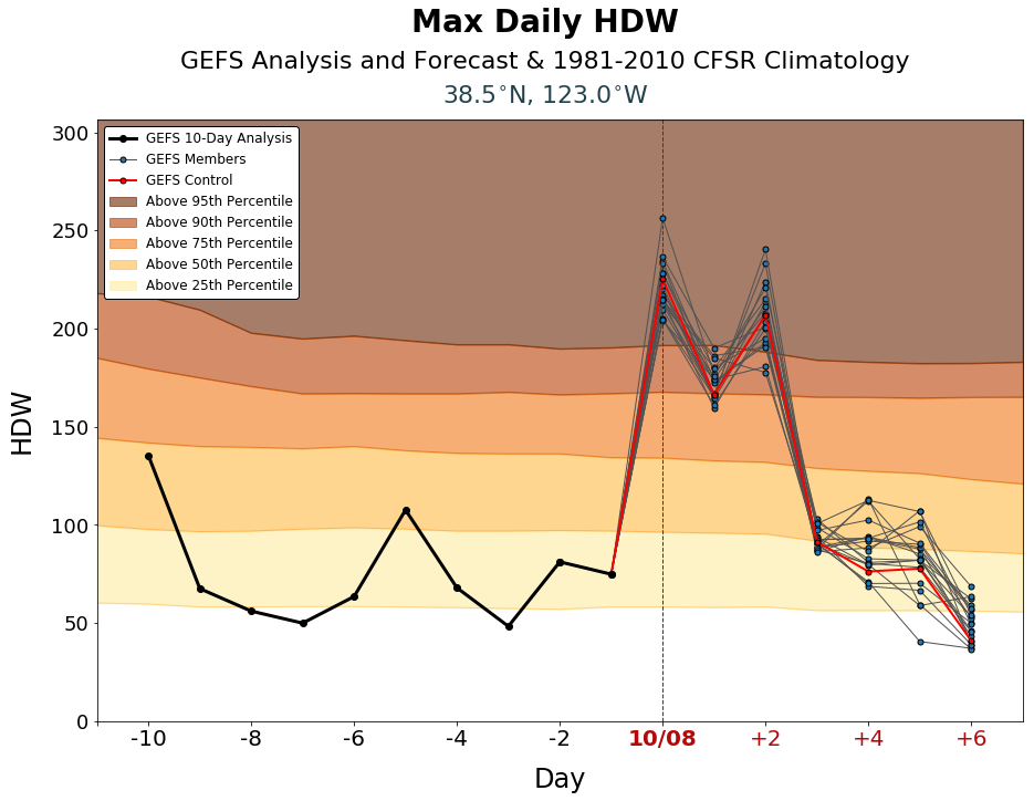
The Hot-Dry-Windy Index for an area 15 miles northwest of Santa Rosa, California.

Weather forecasters expect the wildland fire danger in some areas of  California to be extreme Tuesday night and into Thursday.  Strong north to northeast winds accompanied by low humidity has triggered Red Flag Warnings putting land managers on edge. PG&E is so worried it is proactively turning off the electrical power to 600,000 addresses in nearly 30 northern, central, coastal, and Bay Area counties.

We consulted a fairly new fire danger forecasting tool to see how it analyzed what firefighters will be faced with for  the next few days. The Hot-Dry-Windy Index (HDW) is described as being very simple and only considers the atmospheric factors of heat, moisture, and wind. To be more precise, it is a multiplication of the maximum wind speed and maximum vapor pressure deficit (VPD) in the lowest 50 or so millibars in the atmosphere.

The products, displayed as charts, show the index for the preceding 10 days and the forecast for the next 7 days. For the current and following days you will see results of the Global Ensemble Forecast System (GEFS), which is a weather forecast model made up of 21 separate forecasts, one control (in red) and twenty perturbations. The reasoning for showing 21 different forecasts is to quantify the amount of uncertainty in a forecast by generating an ensemble of multiple forecasts, each minutely different, or perturbed, from the original observations.The HDW only only uses weather information – fuels and topography are not considered by HDW at all. If the fuels are wet or have a high live or dead moisture content it will not be reflected in the data.

At the top of the page is the HDW forecast for an area about 15 miles northwest of Santa Rosa in the Bay Area of California. It predicts the Index will be above the 95th percentile on October 8, above the 90th percentile on October  9, and back up to the 95th percentile on October 10.

Below are HDW predictions for other areas in California.

Hot-Dry-Windy Index Susanville
Hot-Dry-Windy Index, Susanville

Hot-Dry-Windy Index Lake Tahoe
Hot-Dry-Windy Index for the area 30 miles south of Lake Tahoe near the Caples prescribed fire.

Hot-Dry-Windy Index Bakersfield
Hot-Dry-Windy Index for the Bakersfield and Lancaster area.

Hot-Dry-Windy Index San Diego County
Hot-Dry-Windy Index for eastern San Diego County

PG&E plans to turn off power to 600,000 addresses to prevent wildfires

This is a response to a forecast for strong winds and Red Flag Warning conditions

PG&E power turn off
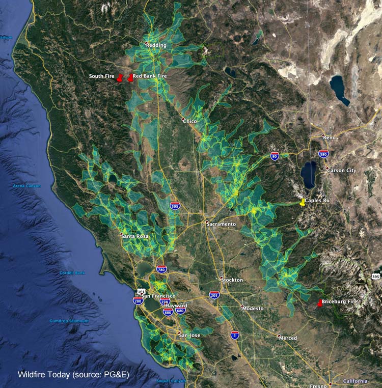
Areas in which PG&E expects they will turn off the power Wednesday morning, October 9, 2019.

Pacific Gas and Electric is notifying customers at 600,000 addresses that their electricity will be turned off as a proactive response to a forecast for enhanced wildfire danger. The plan is to throw the switches at 4 a.m. October 9 which could affect millions of people in nearly 30 northern, central, coastal, and Bay Area counties. Based on the latest weather forecasts and models, PG&E anticipates the period of peak winds will occur from early Wednesday morning through midday Thursday. (UPDATE: Tuesday afternoon PG&E raised the number of addresses that will have their power shut off to 800,000)

Since the company’s power lines have caused numerous wildfires in recent years, especially during windy conditions, they have decided to turn off the  power during periods of high fire danger rather than harden their infrastructure to  make it resistant to strong winds.

The weather forecast for some of the areas identified as part of this “Public Safety Power Shutoff” predicts humidity in the teens and north to northeast winds of 15 to 25 mph gusting at 40 to 50 mph beginning late Tuesday night and lasting into Thursday.

PG&E is asking customers to:

  • Update their contact information at pge.com/mywildfirealerts or by calling 1-866-743-6589 during normal business hours. PG&E will use this information to alert customers through automated calls, texts, and emails, when possible, prior to, and during, a Public Safety Power Shutoff.
  • Plan for medical needs like medications that require refrigeration or devices that need power.
  • Identify backup charging methods for phones and keep hard copies of emergency numbers.
  • Build or restock your emergency kit with flashlights, fresh batteries, first aid supplies and cash.
  • Keep in mind family members who are elderly, younger children and pets. Information and tips including a safety plan checklist are available at pge.com/wildfiresafety.

Josh Brolin reflects on the movie Joker and mental health

Josh Brolin
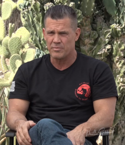
Josh Brolin before the interview, October 10, 2017.  He was wearing an Eric Marsh Foundation shirt.

It might be easy to think of an actor as a person who memorizes lines and then stands in front of a camera to repeat them. But when you learn more or talk with them you might find that they can be more complex.

When I met Josh Brolin before the premier of “Only the Brave” to interview him about playing the role of Eric Marsh, one of the 19 firefighters that were killed on the Yarnell Hill Fire, I came away thinking that he was self aware, empathetic, intelligent, and thoughtful. I began following him on Instagram which only confirmed that first impression especially Saturday when he posted his feelings about the just-released movie “Joker”. What he wrote was, yes, intelligent and thoughtful.

I have not seen the movie, but descriptions usually include the words “dark” and “disturbing”. Fearing that something unpleasant could happen, some theaters banned any customers wearing masks.

Here is the brief  description of the film written by the movie’s producers:

Forever alone in a crowd, failed comedian Arthur Fleck seeks connection as he walks the streets of Gotham City. Arthur wears two masks — the one he paints for his day job as a clown, and the guise he projects in a futile attempt to feel like he’s part of the world around him. Isolated, bullied and disregarded by society, Fleck begins a slow descent into madness as he transforms into the criminal mastermind known as the Joker.

And, Josh’s thoughts:


View this post on Instagram


To appreciate “Joker” I believe you have to have either gone through something traumatic in your lifetime (and I believe most of us have) or understand somewhere in your psyche what true compassion is (which usually comes from having gone through something traumatic, unfortunately). An example of dangerous compassion would be to, say, make a film made about the fragility of the human psyche, and make it so raw, so brutal, so balletic that by the time you leave the theatre you not only don’t want to hurt anything but you desperately want an answer and a solution to the violence and mental health issues that have spun out of control around us. This film makes you hurt and only in pain do we ever want to change. It’s all in the irony of trauma — a fine line between the resentment of wanting to hurt society back for raping you of a decent life, for not protecting you, and accepting what feels like alien feelings with softening to those others who seem freakish in our era of judgment, and digital damnation. Like kids in Middle School: man, they can just be mean. For no reason. And, sometimes, those awful little clicky kids breed an evil in someone that rages much later, when everyone pretends we are all back to normal, when we all thought it had just manned up and gone away. We have a habit of hating and ostracizing and dividing and sweeping our problems under the rug. Joker, is simply lifting the rug and looking underneath it. Nothing more. Nothing less. It’s there.

A post shared by Josh Brolin (@joshbrolin) on

Some people have a knack for looking at an issue and exposing the core. Josh wrote about the “awful little clicky kids” in middle school that “breed an evil in someone that rages much later”.

Some of those awful kids don’t change when they become adults and can still foment hate and ostracize those who are not the same as them. Not only do those kids need counseling, but they may also need it as adults, as do their victims.

I have, thankfully, only met a few people in my life that I would describe as evil — someone who intentionally and maliciously strives to inflict harm on others, emotionally or physically, for reasons known only to them. There may not be a conventional reason or motivation for their behavior. It could be a baked-in reflex in response to a long ago, even forgotten, trauma, or bad wiring in the brain.

Regardless of the origin, we need to do more to make mental health treatment more accessible and affordable.

Red Flag Warnings in six states

Above: Red Flag Warnings (red) and Fire Weather Watches (yellow), updated at 2:25 p.m. PDT Oct. 8, 2019. Times are CDT. 

Red Flag Warnings and Fire Weather Watches for gusty winds and low humidity have been posted for areas within six states. Times shown are CDT.

(Red Flag Warnings can be modified throughout the day as NWS offices around the country update and revise their weather forecasts.)

Briceburg Fire burns hundreds of acres north of Mariposa, CA

The fire is burning on both sides of Highway 140 that leads to Yosemite National Park

UPDATED at 1:53 p.m. PDT Oct. 8, 2019

Briceberg Fire
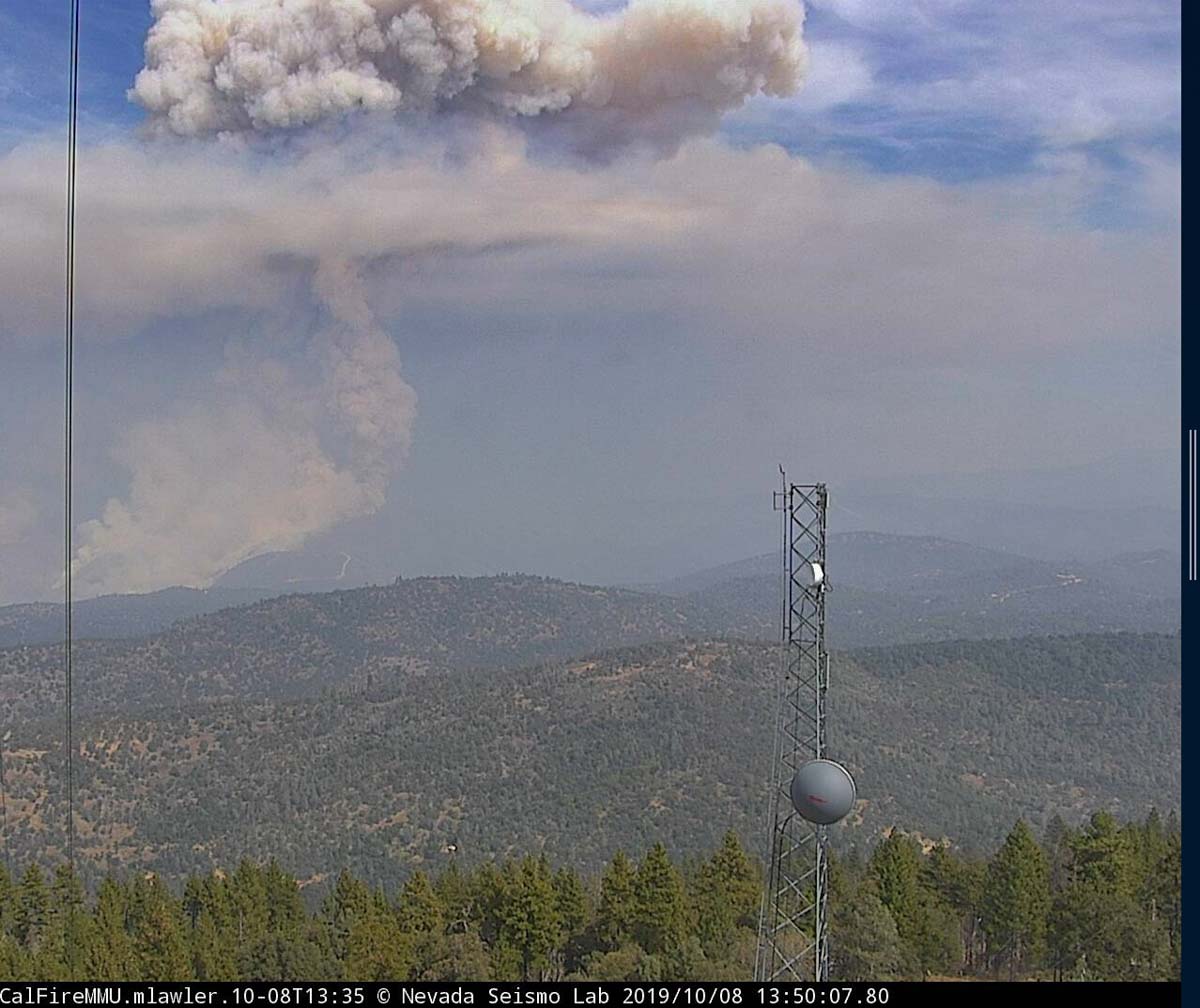
The Briceburg Fire as seen from the Mt. Bullion camera near Mariposa, CA at 1:50 p.m. PDT Oct. 8, 2019.

Activity on the Briceburg Fire  north of Mariposa, California, increased after noon when the smoke column broke through the inversion.


9:31  a.m. PDT October 8, 2019

Briceburg Fire
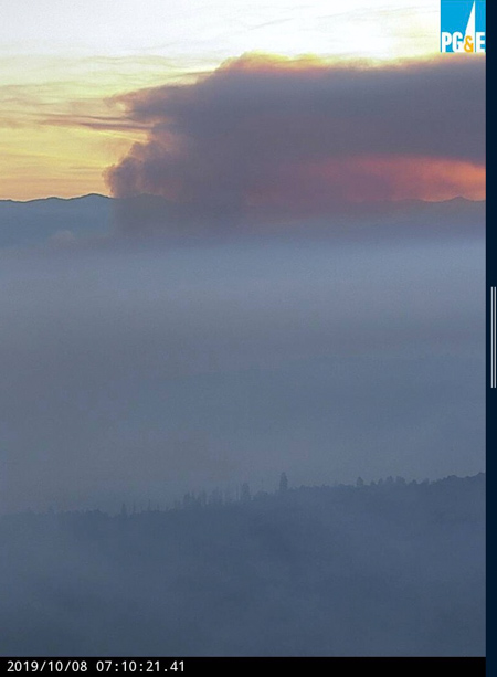
The Briceburg Fire as seen from the Bullion camera near Mariposa, CA at 7:10 a.m. PDT Oct. 8, 2019.
map Briceburg Fire Yosemite highway
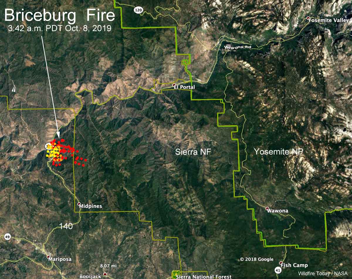
Map showing heat detected on the Briceburg Fire at 3:42 a.m. PDT October 8, 2019. It had become well established inside the Sierra National Forest.

The map above shows heat detected by a satellite on the Briceburg Fire at 3:42 a.m. Tuesday. It indicates growth on the north and east sides, some of which could be firing  operations by firefighters to stop the spread.

CAL FIRE is reported at about 9 a.m. PDT Tuesday morning that it has burned 800 acres. Our very,  very rough unofficial estimate leads us to believe that with the firing operation it could be twice that size.

The fire is on  both sides of Highway 140 just west of the Sierra National Forest 12 air miles southwest of the El Portal entrance to Yosemite, 7 miles north of Mariposa, and one mile west of the Sierra National Forest. At 6:46 a.m. PDT Highway 140 was closed in the Briceburg area.

Below: time lapse video of the Briceburg Fire as seen from the Bullion camera near Mariposa, CA.


Continue reading “Briceburg Fire burns hundreds of acres north of Mariposa, CA”

Firefighters to conduct aerial ignition operation on the Decker Fire

The fire has burned 6,155 acres south of Salida, Colorado

Above: The west side of the Decker Fire, October 5, 2019. InciWeb.

11:44 a.m. MDT October 6, 2019

Even though the Decker Fire south of Salida, Colorado is not a full suppression fire, quite a bit of fireline has been constructed on the perimeter. However, Mark Giacoletto’s Type 1 Incident Management Team reports that only 5 percent of the fire is contained.

(To see all articles on Wildfire Today about the Decker Fire, including the most recent, click here.)

Most of the recent fire activity has occurred on the west side (see map below). Over the last two days the fire has grown by 331 acres, bringing the total to 6,155 acres.

The photo at the top of the article shows that portions of the fire on the west side are creeping into stands of Aspen, which can slow the spread considerably.

map Decker Fire
Map showing the perimeter of the Decker Fire (in red) at 10:08 p.m. MDT Oct. 5, 2019. The white line was the perimeter about 48 hours before.

Residents may see more smoke in the area Monday as fire managers burn out some areas on the east side. The objective is to remove fuel and slow the spread of the main fire. The aerial ignition operation will be conducted from a helicopter.

Resources assigned to the fire include: 23 hand crews, 28 engines, 3 dozers, 6 helicopters, 3 fixed wing aircraft, and 10 water tenders for a total of 806 personnel.

There is now an interactive map available for the Decker Fire at https://arcg.is/1zPGWH. It will allow you to enter your address to see your location relative to the fire, it provides a measuring tool to measure distance, and can give hunters information related to forest closures. The fire perimeter on the map will be updated once a day.