Flying through a pyrocumulonimbus cloud

NASA Earth Observatory image Williams Flats Fire
NASA Earth Observatory image of the Williams Flats Fire by Joshua Stevens, using Landsat data from the U.S. Geological Survey.

(This article first appeared at earthobservatory.nasa.gov)

Atmospheric scientists regularly take note when satellites detect thunderheads rising above columns of wildfire smoke. These “fire clouds”—experts call them pyrocumulonimbus (pyroCb) or cumulonimbus flammagenitus—are caused when fires loft enough heat and moisture into the atmosphere to produce thunderstorms.

On August 8, 2019, a team of atmospheric scientists got an exceedingly rare look at these clouds as they were forming. NASA’s DC-8 flying laboratory passed directly through a large pyrocumulonimbus that day as it was rising from a fire in eastern Washington. The flight was part of a joint NOAA and NASA field campaign called FIREX-AQ. Scientists are studying the composition and chemistry of smoke to better understand its impact on air quality and climate.
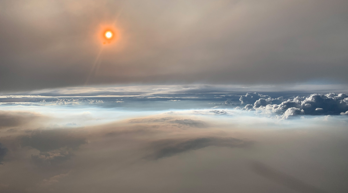
Williams Flats Fire
August 8 photo by David Peterson (U.S. Naval Research Laboratory).

David Peterson, lead forecaster for FIREX-AQ, was in the cockpit of NASA’s DC-8. “The views were absolutely stunning,” said Peterson. “Very few photographs of large pyroCbs are available, especially from the air.”

The photograph above, shot from roughly 30,000 feet (9 kilometers), shows the setting Sun shining through thick smoke at 8 p.m. Mountain Time. Particles in the smoke reflect light in ways that make the Sun appear orange. The photograph below shows the smoke plume (gray) that fed the pyrocumulonimbus cloud (white).

The flight was the most detailed sampling of a pyrocumulonimbus in history, explained Peterson. A second research aircraft flew over the plume a few hours earlier in the day, and mobile labs on the ground also made detailed measurements.
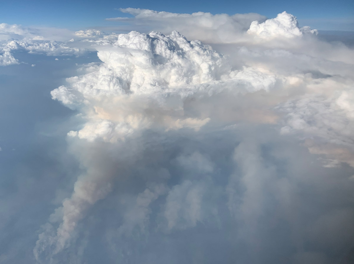
Williams Flats Fire
August 8 photo by David Peterson (U.S. Naval Research Laboratory).

“PyroCb are like large chimneys, transporting a large quantity of smoke into the lower stratosphere,” explained Peterson.

When smoke does reach the stratosphere, it tends to spread globally and remain high in the atmosphere for longer periods—months or even years—than smoke that stays in the lower troposphere. One recent study concluded that the largest fire clouds can even lift quantities of smoke aerosols into the lower stratosphere that are comparable to a moderate-sized volcanic eruption.

An early morning thunderstorm ignited the Williams Flats Fire on August 2, 2019. The Operational Land Imager (OLI) on Landsat 8 acquired a natural-color image of the blaze (at the top of the page) as it approached the north bank of the Columbia River on August 7, 2019. The image is natural color (OLI bands 4-3-2), overlaid with the infrared and shortwave infrared signature of actively burning fires.

Story by Adam Voiland of NASA Earth Observatory.

Number of large air tankers on USFS contracts drops

There are 13 exclusive use, and 8 call when needed. Three fewer than last year on CWN list.

(This article first appeared on Fire Aviation)

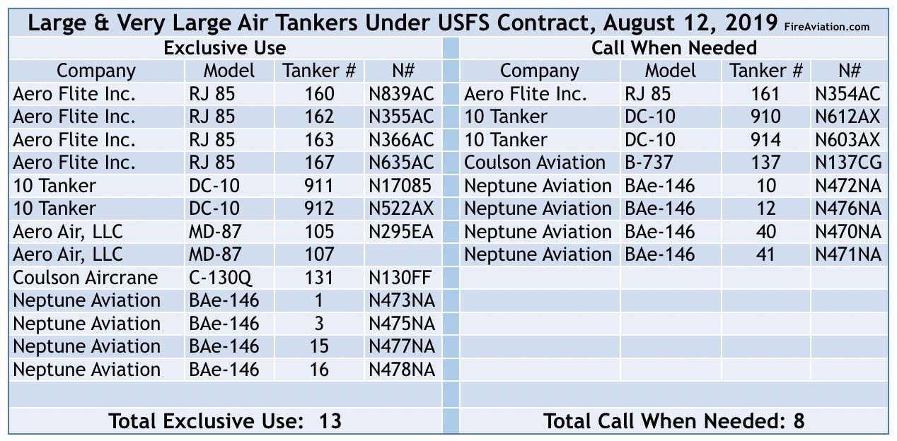
The list of large and very large air tankers has changed since 2018. The number on the very coveted exclusive use (EU) contracts is the same, 13, but there are three fewer on call when needed contracts (CWN), 8. This could change later in the year but today there are a total of 21 air tankers on both types of contracts, down from 24 last year.

Aero Flite, Aero Air, and Neptune all swapped out some EU aircraft but each still has the same number of allocated slots.

Air Tanker List
Air tankers under U.S. Forest Service Contract, August 12, 2019. Source: USFS.

On the CWN list, Aero Flite went from four to one aircraft and Coulson dropped their L-382G and substituted a B-737 which began working in North America for the first time last week. Neptune swapped some of their BAe-146s but 10 tanker did not make any changes on either list.

Today when we asked Kaari Carpenter, a Public Affairs Specialist for the Forest Service, when the agency was going to offer air tanker contracts based on the call when needed solicitation issued May 30, 2018, she said, “We expect an award on this contract very soon.”

The 2019 wildfire season has been much slower than average so far this year, which is fortunate considering the small number of air tankers available on Forest Service contracts — from 44 in 2002 on EU contracts down to 13.

So far this year a total of 3.6M acres have burned in the U.S., compared with 4.6M for the average to date. It has been far busier than usual in Alaska accounting for 2.4M acres, two-thirds of the U.S. total. Only 1.2M acres have burned in the other 49 states — which I estimate is approximately one-third of the average.

Researchers study and film the depths and heights of a forest fire

The scientists captured video that is mesmerizing

Forest Service fire research
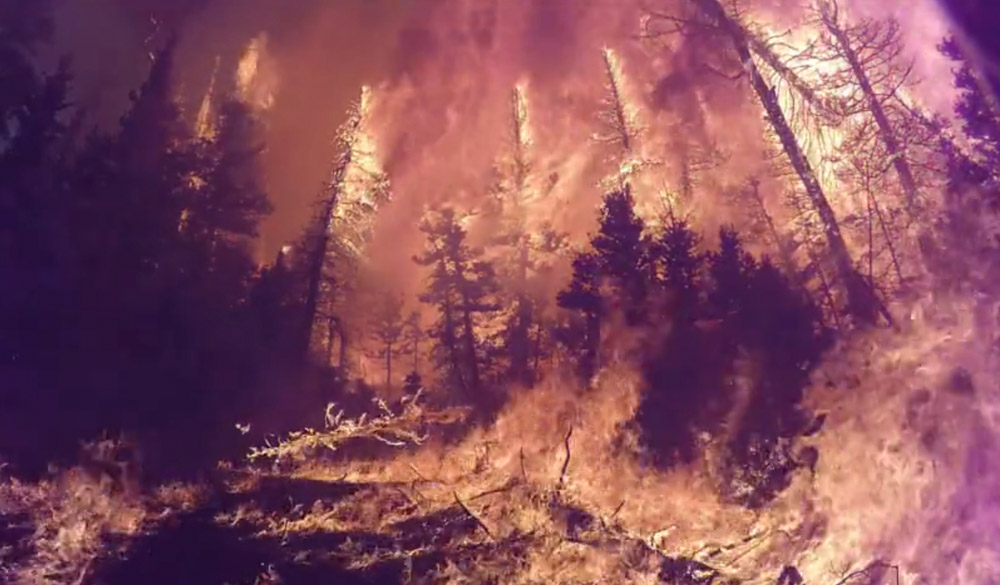
Screenshot from the USFS video below filmed in the fire.

By: Gail Keirn, Rocky Mountain Research Station-Fort Collins, Colorado; Matt Burks, Pacific Northwest Research Station-Corvallis, Oregon; John Zapell, Fishlake National Forest-Richfield, Utah
July 29th, 2019

Forest fires often reach or exceed temperatures of 2,000° Fahrenheit—that’s equivalent to one-fifth the temperature of the surface of the sun. What is the impact of such high temperatures on the soil and plants of our forests? And how do the intensity and heat of a wildfire impact its behavior, smoke and the surrounding weather?

Answering these questions is challenging since it is hard to predict when and where fires will occur. Therefore, USDA Forest Service scientists and others with the interagency Fire and Smoke Model Evaluation Experiment, or FASMEE, teamed up with the Fishlake National Forest Richfield Ranger District to study a prescribed fire from start to finish.

After months of planning and preparation, Fishlake National Forest fire crews ignited more than 2,000 acres of Utah forest in an effort to consume living upper canopy vegetation and initiate growth of new vegetation. This June 2019 prescribed fire was designed to restore aspen ecosystems by removing conifer trees and stimulating the regrowth of aspen.

Researchers at the Pacific Northwest Research Station and Rocky Mountain Research Station, as well as other FASMEE participants, saw the fire as a unique opportunity for study. Prior to the fire, Forest Service research experts took measurements of the forest vegetation and fuel loads. They also set up special fire-proof equipment to record and measure the heat of the fire throughout the project. Embedded below is a video recorded during the burn.

Forest Service fire research
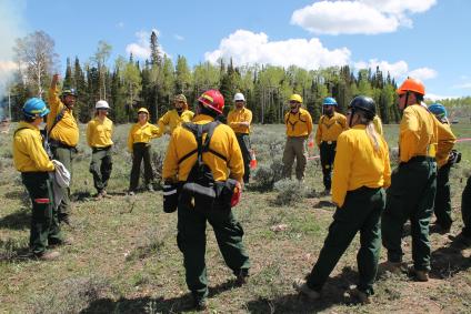
Researchers prepare for the start of a prescribed fire at Fishlake National Forest. More than 40 scientists from multiple agencies participated in the effort, gathering a variety of data on the fire itself and its impacts. USDA Forest Service photo.

During the fire, scientists used LiDAR, radar, aircraft and satellite imagery, weather and atmospheric measurements, and ground monitoring to study the fuel (dead materials) consumed, fire behavior and the fire’s impact on living vegetation. Scientists will continue to monitor the area to determine how vegetation recovers after fire.

“More than 40 scientists from multiple agencies participated in the effort, gathering a variety of data on the fire itself and its impacts,” said Pacific Northwest research forester Roger Ottmar, one of the lead scientists for the project. “The data is invaluable to our efforts to predict fire behavior, smoke impacts and the short- and long-term effects of extreme fires.”

Over the next several months, scientists will gather more data as the landscape recovers, comparing burn severity maps generated from remote sensors with observed plant regrowth. Other data from the fire is already being used to validate and improve models that predict fire and smoke severity, as well as to improve firefighter safety standards and guidelines.

Building upon this success, experts are planning a similar project for later this fall to continue studying and learning about fire.

Thanks and a tip of the hat go out to Rick. Typos or errors, report them HERE.

Memorial rededicated for the crew of Air Tanker 130

Posted on Categories Uncategorized
memorial crew C-130 crash Walker California
The new memorial for the crew of Air Tanker 130 at Walker, California, August 10, 2019. Photo by Humboldt-Toiyabe National Forest.

(This article first appeared at Fire Aviation)

The rededication of the memorial for the crew of Air Tanker 130 occurred as planned on August 10.

Steve Wass, Craig LaBare, and Mike Davis were killed June 17, 2002 when their C-130 crashed while battling the Cannon Fire at Walker, California.

The memorial honoring the crew near the accident site was showing its age after having been in place for a decade and a half. On Friday the new monument for the crew was unveiled on Highway 395 near the site where their air tanker crashed. (map)

These photos were provided by the Humboldt-Toiyabe National Forest through their Twitter account (@HumboldtToiyabe) where they wrote:

Fire staff attended the rededication ceremony and unveiling of the new memorial today for the crew of Tanker 130 near Walker, Ca. Steve Wass, Craig LaBare, and Mike Davis lost their lives when the tanker crashed during suppression operations on the Cannon fire in June of 2002.

More details about the new memorial were posted yesterday.

memorial crew C-130 crash Walker California
The new memorial for the crew of Air Tanker 130 at Walker, California, August 10, 2019. Photo by Humboldt-Toiyabe National Forest.
memorial crew C-130 crash Walker California
Scene from the rededication of the memorial for the crew of Air Tanker 130 at Walker, California, August 10, 2019. Photo by Humboldt-Toiyabe National Forest.
memorial crew C-130 crash Walker California
Scene from the rededication of the memorial for the crew of Air Tanker 130 at Walker, California, August 10, 2019. Photo by Humboldt-Toiyabe National Forest.

More than 7,000 lightning strikes in Washington and Oregon Saturday

lightning strikes recorded Washington Oregon
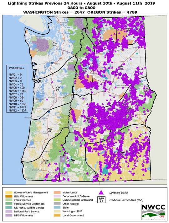
There were 7,436 lightning strikes recorded in Washington and Oregon during the 24-hour period ending at 8 a.m. PDT August 11, 2019.

The Northwest United States experienced another day of lightning Saturday.

Lightning strikes map
Lightning strikes and precipitation observed during the 24-hour period ending at 6 a.m. MDT August 11, 2019.

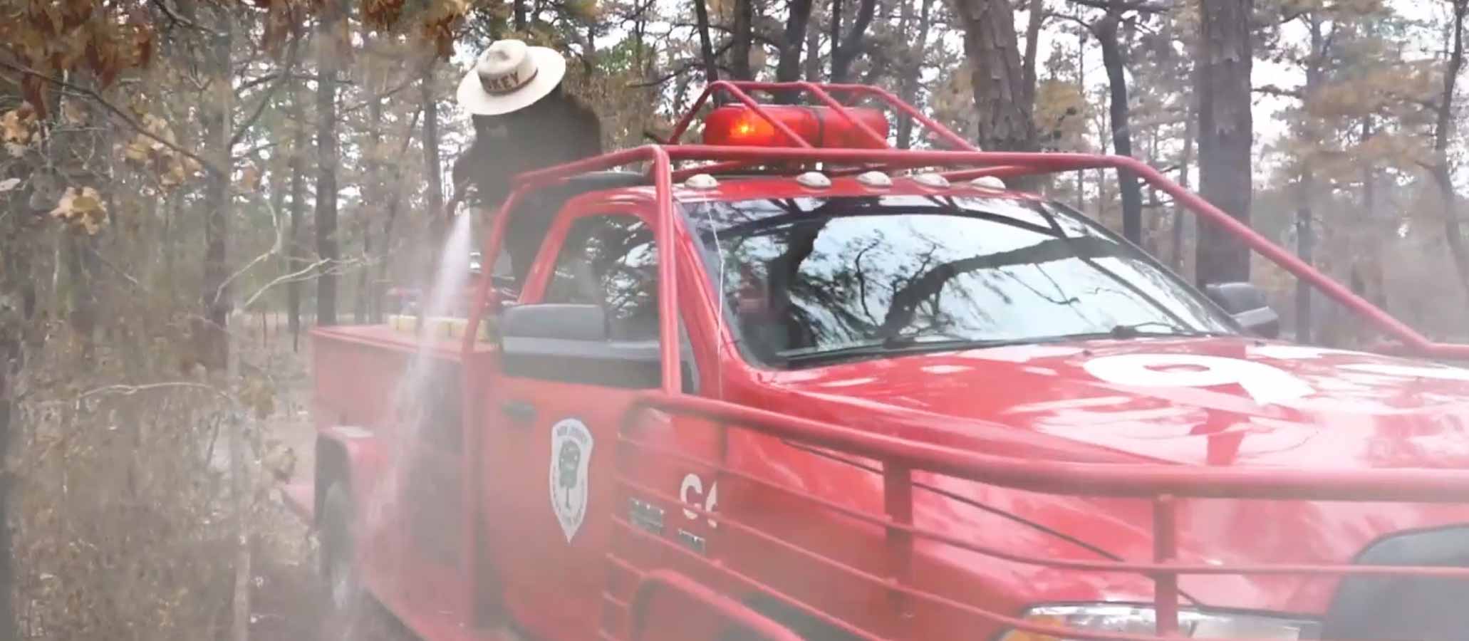
Special tribute to Smokey Bear by New Jersey Forest Fire Service

Smokey Bear video New Jersey
Screenshot from the New Jersey Forest Fire Service video below.

As part of the celebration of the 75th year of the Smokey Bear wildfire prevention campaign, the New Jersey Forest Fire Service produced this video tribute.

Smokey is reminiscing about old times until the video switches to present day halfway though when he is called out to a wildfire. The video is set to the song “Nostalgic” by the New Jersey based band A R I Z O N A.

The video showcases many notable locations throughout the state including Mt. Tammany, Storybook Land, and the Statue of Liberty.