Warm, dry, breezy weather awakens Klondike Fire in Southwest Oregon

After being relatively quiet for weeks the fire jumped firelines Sunday requiring evacuations in Agness

(UPDATED at 5:10 a.m. PDT October 16, 2018)
map Klondike Fire
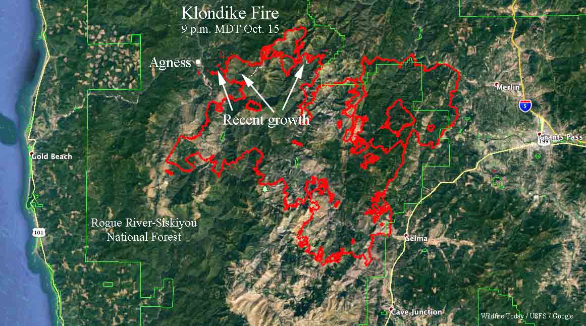
The red line on the map was the perimeter of the Klondike Fire at 9 p.m. October 15, 2018. The white line shows where the perimeter was before the October 14-15 additional growth. Click to enlarge.

The map of the Klondike Fire above is a result of mapping by a fixed wing aircraft at 9 p.m. PDT October 15. The new growth on October 14 and 15 added another 4,968 acres to bring the total up to 172,287 acres.

The weather forecast for the fire area on Tuesday (Agness, OR) predicts a high temperature around 80, relative humidity in the teens, and 5 mph east to northeast winds. The area is not under a Red Flag Warning.
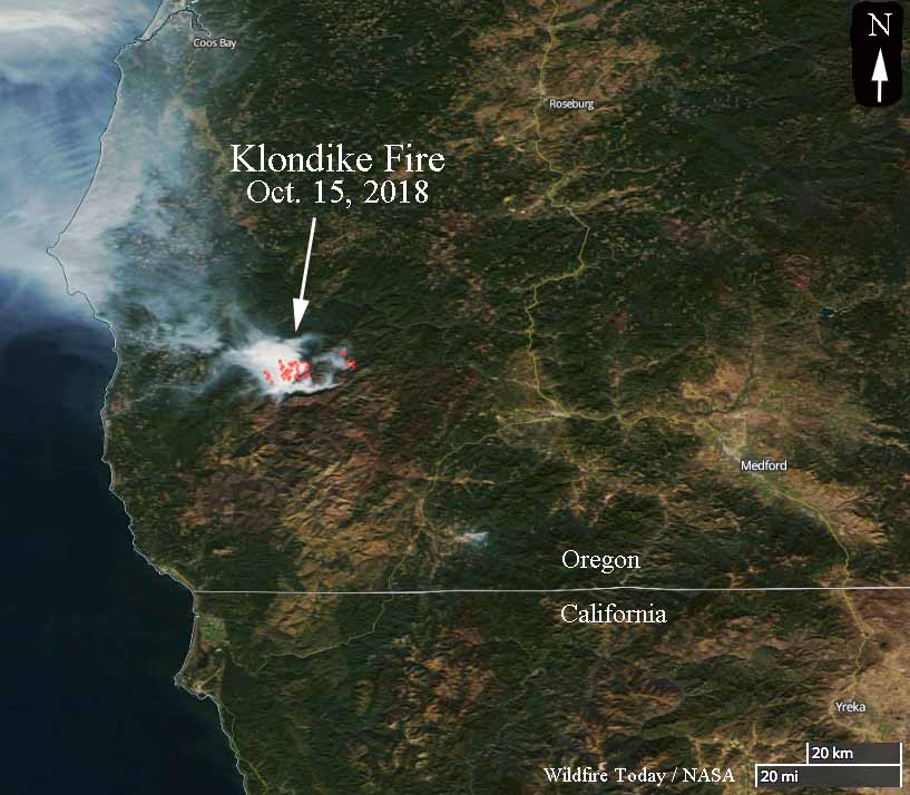

Klondike Fire in southwest Oregon
A satellite photo taken October 15 showing heat (the red dots) and smoke on the Klondike Fire in southwest Oregon.

The Klondike Fire had been quiet for weeks until warm, dry, breezy weather on Sunday brought it back to life, burning thousands of acres outside the firelines and requiring evacuations in the small town of Agness 20 miles northeast of Gold Beach, Oregon. The Sheriff’s Office in concurrence with fire officials  made the determination that evacuations were appropriate for residents north of the Rogue River and in the areas of Oak Flat, Spud Road, and along the 33 road in Agness.

Incident Management Teams had released 171 fire personnel over the last seven days, to bring the total down to 316. The 167,423-acre fire had not increased in size for over a week. Approximately 250 additional resources have been requested, including aircraft, engines, and Type 1 Interagency Hotshot Crews (IHC). Northwest Incident Management Team 7 (NWIMT7) assumed command of the October 14, 2018 at 8:00 p.m.

The Oregon Governor has declared the Klondike Fire to be a “conflagration”which allows the State Fire Marshal to mobilize firefighters and equipment to assist local crews.
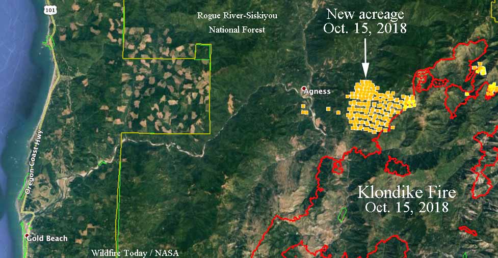
map Klondike Fire
The red line on the map was the perimeter of the Klondike Fire the last time it was mapped, on October 12, 2018. The yellow dots represent heat detected by a satellite at 4:54 a.m. PDT October 15, 2018. We will update this map when new data becomes available.

At 2 p.m. Monday afternoon a weather station near Agness recorded 73 degrees, 10 percent relative humidity, and 2 mph SSE winds. The maximum wind gust over the previous 24 hours was 20 mph Sunday evening.

Our very unofficial analysis of Sunday’s activity indicates that approximately 4,500 additional acres burned on the northwest side of the fire east of Agness. Firefighters have requested a Monday night infrared mapping flight to get a more accurate assessment.

Strong, dry winds hit California

PG&E has proactively shut off power to tens of thousands of customers to prevent vulnerable power lines from starting fires

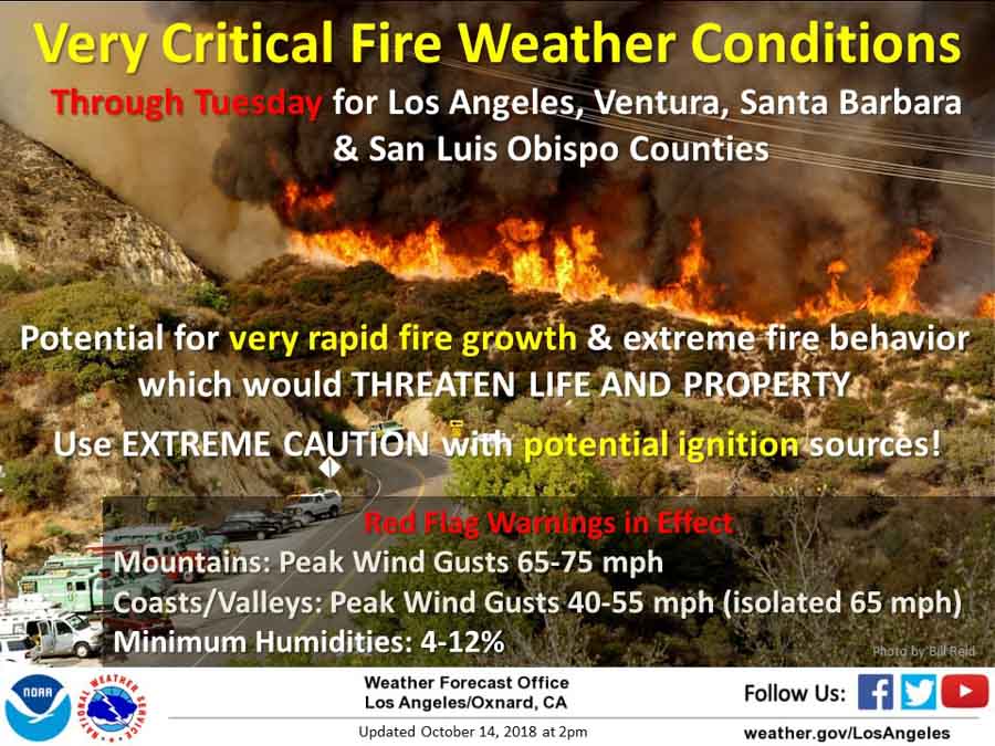
Red Flag Warnings CaliforniaWith a forecast for strong Santa Ana winds that are predicted to gust above 65 mph in some areas firefighters and utility companies are making preparations — some to prevent fires and others to suppress them after they start.

Sunday night Pacific Gas and Electric turned off the power for 59,000 of their customers in areas of six Northern California counties — Amador, Calaveras, El Dorado, Lake, Napa, and Sonoma — reasoning  that their electricity infrastructure is vulnerable to the strong winds, which could ignite fires.

PG&E power shut off traffic signalsPG&E sent out a tweet asking residents of those areas to “Please be safe at intersections where traffic signals are out”.

In the south part of the state Southern California Edison warned 130,000 customers they may shut off power in parts of Ventura, Los Angeles, Orange and San Bernardino counties.

The National Weather Service has issued Red Flag Warnings for large areas of southern California through 10 p.m. Tuesday for 25 to 45 mph winds that could gust in some areas at 65 or 75 mph with humidities ranging from 4 to 12 percent.

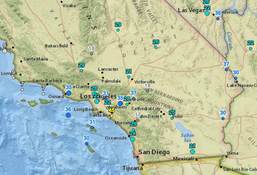
Wind gusts at 9 a.m. PDT October 15, 2018 California
Wind gusts at 9 a.m. PDT October 15, 2018.

Several Red Flag Warnings are in effect in areas of Northern California until mid-day Monday or 1 a.m. Tuesday for 15 to 25 mph winds gusting at 35 to 45 mph along with very low humidities.

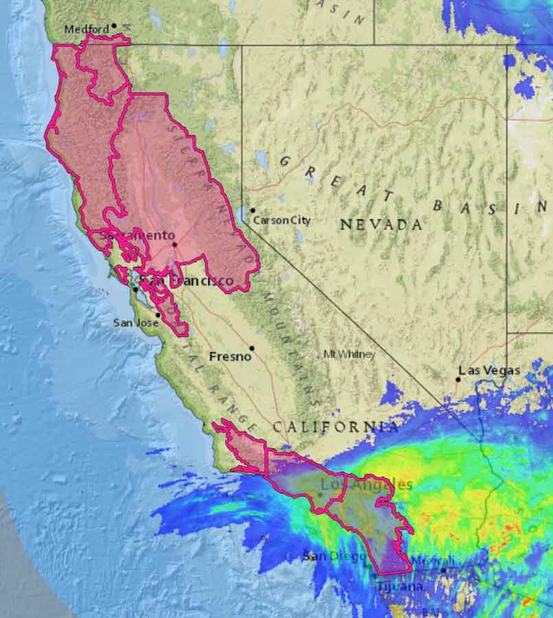
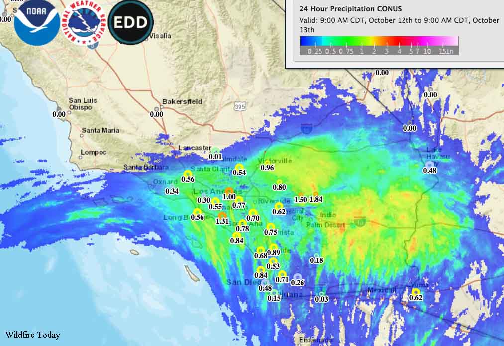
Many areas in Southern California from Los Angeles to San Diego received over half an inch of rain Friday which could have an effect on the spread of wildfires until the fine fuels are dried by the winds.

Red Flag Warnings precipitation california
Red Flag Warnings in California for October 15 with an overlay showing precipitation that occurred October 12-13, 2018.

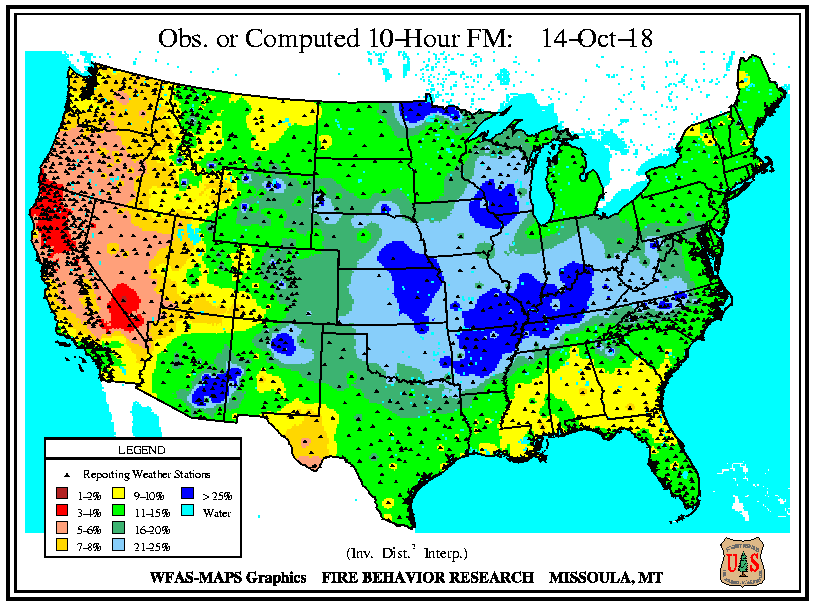
On Sunday the moisture content of ten-hour time lag fuels in those areas was still relatively high, at 11 to 15 percent.  Ten-hour fuels include vegetation 0.25-inch to 1-inch in diameter.

10-hour time lag fuel moisture
Moisture content on October 14 of 10-hour time lag fuels (less than one-half inch in diameter).

But Northern California was a different story with 3 to 4 percent moisture content. These numbers will be lower at both ends of the state after a day or two of strong, dry winds.

Technology increasingly being used by firefighters in Oregon

camera detect wildfire Oregon
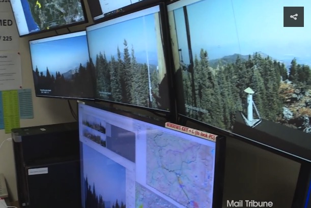
Cameras are used to detect wildland fires in a detection center in Oregon.

(Originally published at 9:51 p.m. PDT October 13, 2018)

Wildland firefighters in Oregon and other locations are increasingly using technology to streamline dispatching, map fires, communicate, detect fires, and enhance situational awareness. An article at the Mail Tribune covers advances in fire detection, drones, mapping, and satellite imagery. Below are two excerpts.

…It’s called the detection center, and ODF employees who man its viewing stations are constantly on the lookout for just-sparked wildfires.

“Typically, what we’re looking for are slight movements,” [Chris] James says while gesturing at a bank of monitors that displays multiple views of the region’s hazy, forested landscape.

Each monitor contains four pictures that rotate through on the screens and are spaced over time, giving ODF workers the ability to see fires.

“We’re looking at those pictures for any sign that we don’t recognize, that we haven’t seen before, and that keys us up on smoke,” says James, a detection center supervisor.

The Bureau of Land Management utilized drone technology for a variety of purposes, including infrared heat detection, mapping, and scouting certain areas of terrain for possible fire lines. Unrelated to surveillance — but no less interesting — the agency utilized some of the unmanned aircraft to haul in supplies. The drones also were used for burnout purposes, dropping ping pong balls … which triggered a chemical reaction that ignited the plastic spheres.

We checked with Gil Dustin who leads the Bureau of Land Management Unmanned Aircraft Systems program. He said the federal land management agencies have not used drones to haul supplies. The aircraft they have been flying can only carry a few pounds at most. One day they may be resupplying firefighters with drinking water, food, fire hose, pumps, and chain saw fuel, but we are not there yet.

Mr. Dustin said years down the road helibases are going to look very different compared to what we are seeing today.

Thanks and a tip of the hat go out to Kelly.
Typos or errors, report them HERE.

It rained in Southern California ahead of Santa Ana wind event

(Originally published at 9:10 a.m. PDT October 13, 2018)

Significant amounts of rain accompanied by copious amounts of lightning fell in Southern California Friday night ahead of a predicted moderate Santa Ana wind event that is expected to begin Sunday afternoon and intensify on Monday and Tuesday.

Many areas from Los Angeles to San Diego received over half an inch and there is a chance it could continue on Saturday. Beneficial rains fell in most areas, but there was too much in some of the desert areas where flooding was reported in the Coachella Valley and Imperial County. Some of the highest totals included 1.54″ at Ocotillo Wells and 1.10″ at Indio.

Accumulated precipitation
Accumulated precipitation during the 24 hours ending at 7 a.m. PDT October 13, 2018. Click to enlarge.

Firefighting agencies have been preparing for the strong, dry Santa Ana winds by prepositioning air tankers in Southern California. They were heavily used Friday to quickly knock down the North Park Fire north of San Bernardino before it could burn more than 50 acres.

wind forecast southern california october 15
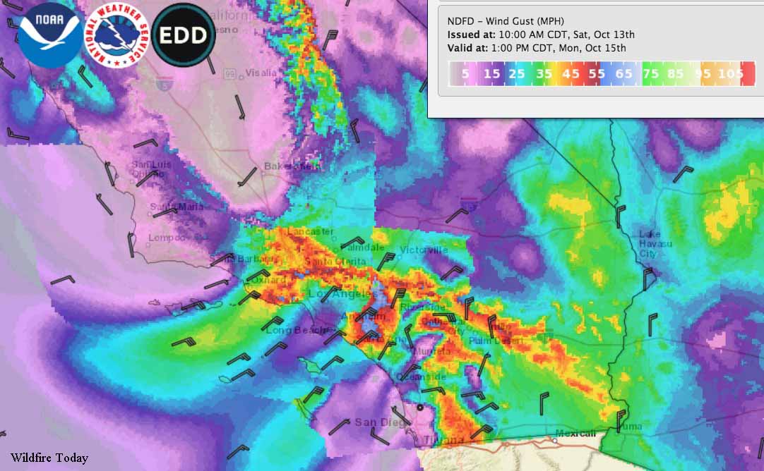
The forecast for wind gusts in Southern California at 11 a.m. PDT Monday October 15, 2018.

Sunday afternoon the strong winds will surface in the mountains, foothills, inland valleys, and Orange County, and will begin to dry the fuels Monday. Winds in these areas will range from 20 to 40 mph with gusts in the wind prone areas up to 60 mph. The rest of the week should be dry and breezy.

Weather forecast for Riverside, California
Forecast for wind, wind gusts, and relative humidity, Riverside, California. NWS.

Firefighters aggressively attack North Park Fire

The fire is north of San Bernardino on the edge of the San Bernardino National Forest

DC-10 drop North Park Fire
A DC-10 comes out of the smoke dropping retardant on the North Park Fire. Screen grab from @ABC7Leticia video below.

(Originally published at 3:49 p.m. PDT October 12, 2018)

Thanks at least in part to the prepositioning of several air tankers and an aggressive attack by firefighters on the ground, a fire that broke out Friday afternoon was hit with overwhelming force. As this is written at 3:49 p.m. Friday the North Park Fire has slowed considerably and the air tankers have returned to their bases.

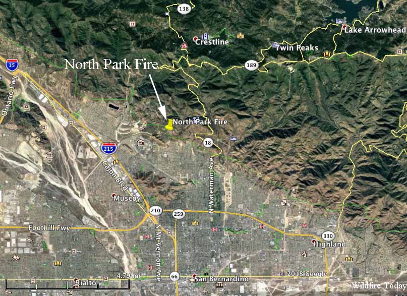
The fire is north of San Bernardino, California on the edge of the San Bernardino National Forest. At 2:56 p.m. PDT the Forest Service reported that it was approximately 50 acres with a rapid rate of spread with no threat to structures. It was being fought by at least 150 firefighters and two helicopters. In addition, the air tankers working on the fire included a DC-10, a C-130, an MD87, and approximately three S-2Ts.

map North Park Fire
Map showing approximate location of the North Park Fire.

ABC7 reported that two individuals have been detained. It is not clear what role, if any, they may have had in regards to the fire.

Ms. Juarez’s video below is very impressive. She shrewdly began filming before the DC-10 Very Large Air Tanker was visible, and captured it as it emerged out of the smoke dropping retardant.

Anticipating strong, dry, Santa winds beginning Sunday or Monday, the fire agencies moved several air tankers into Southern California.

New book of nighttime fire photography

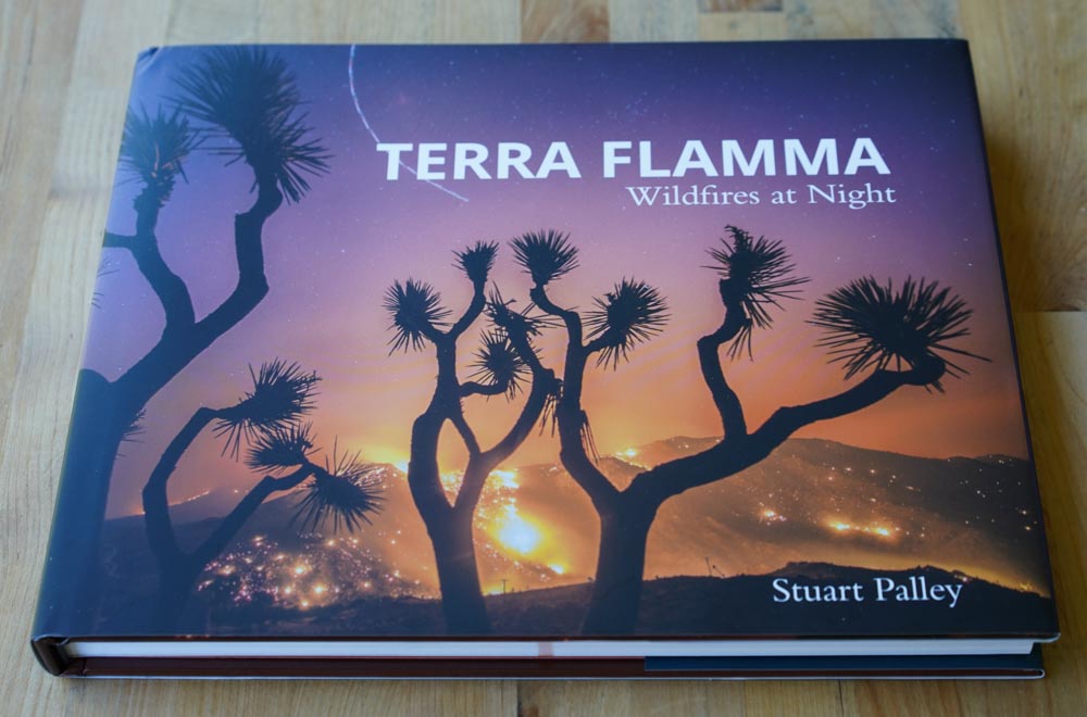
book Terra FlammaTERRA FLAMMA
Wildfires at Night
by Stuart Palley
176 pages, Schiffer Publishing
$25.85 at Amazon

Fires can be deadly, but they can also be beautiful. Most of us have spent time staring at a campfire or fireplace. It can be mesmerizing on a small scale, but when you see hundreds of acres being consumed by flames, it can be hard to turn away.

Television news might cover wildfires even less than they already do if the images were not so fascinating.

Flickering flames on a landscape at night can be captivating. A well-know wildfire photographer has made it an area of special interest during the last five years. After most fire photographers spent hours getting shots of fires during daylight hours and went home to rest, re-hydrate, and edit photos, Stuart Palley would often take advantage of the very special lighting, set up his tripod, and take multi-second exposures keeping the shutter open long enough for the dim light to be captured on the camera’s sensor.

He writes about it in his book that was just released, Terra Flamma; Wildfires at Night:

Soon I found the night shots more interesting than the day. As the painter Vincent Van Gogh said, “I often find that the night is more colorful than the day”.

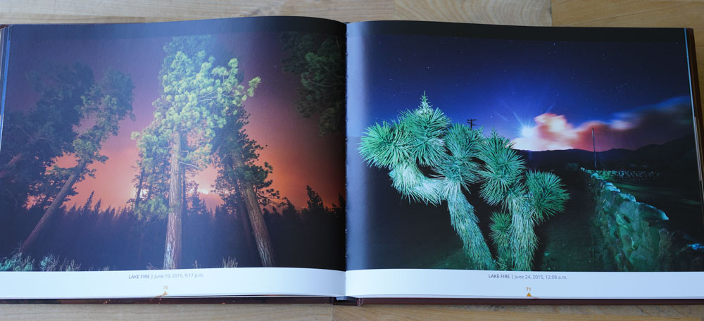
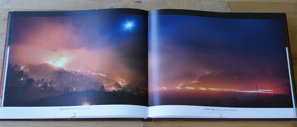
book Terra FlammaThe book is a compilation of 110 color photographs of 39 wildfires shot at night in California over the past 5 fire seasons, including the Rim, Rough, and Thomas Fires. There is also an introductory section about his background, on photographing the fires, and his experience at the incidents in addition to statistics about each wildfire.

Terra Flamma, Mr. Palley explains, is a rough Latin translation for “earth on fire”.  I am not a fan of using words from a foreign language in a motto, company name, or book title. If people reading it don’t speak that language, the words can be meaningless.

I took these three photos of the book cover and some of the pages within, but they do not do justice to the excellent photos and the beautifully printed pages. I didn’t even snap pictures of his best images, not wanting to spoil the pleasure of someone opening the book for the first time.

Too often we see photos that firefighters take at fires that have been tweaked and manipulated within an inch of the pictures’ lives, cranking up the intensity, screwing with the color saturation, adding Instagram filters, or merging three or more photos into one with high dynamic range. Or worse, using the camera’s software to manipulate just one image into what the vendor calls high dynamic range. These can become extremely unrealistic. I have fallen into that trap once or twice, making one very little post production “enhancement” that’s barely noticeable, then one more, and another. Then when done, I have compared the tweaked version to the original and see that they are very dissimilar, and may tell a different story. That’s when I start over.

But Mr. Palley explains that he used “minimal enhancement, with the goal to reproduce what I saw at the fire”.

And it works. His experience as a journalist, news photographer, his masters degree in photojournalism, and years spent chasing wildfires all over California can be seen on the 176 pages.

book Terra Flamma
The cover of Terra Flamma