University chemist and students take flight with groundbreaking wildfire emission study

A flying laboratory carrying researchers from the University of Montana has the capacity to change what we know about future fires

Above: University of Montana and Colorado State University students in the Aircraft Observations and Atmospheric Chemistry course pose in front of their flying laboratory equipped with state-of-the-art instruments to map the smoke over the western US this past summer. Photo credit: Ali Akherati.

MISSOULA – Most aircraft slicing through the smoke above wildfires either drop water or smokejumpers in an effort to manage fire on the ground. But one plane – a flying laboratory carrying researchers from the University of Montana – has the capacity to change what we know about future fires.

This summer, the four-engine cargo plane spent more than 100 hours slicing through smoke above fires burning in the West, collecting data about the chemical composition of smoke and how it changes over time and travel.

The National Science Foundation National Center for Atmospheric Research C-130 research aircraft was based in Boise, Idaho this summer, but it sampled wildfire plumes in California, Oregon, Washington, Idaho, Nevada and Montana. The results will provide a new understanding of air quality and how it may affect populations downwind.

Assistant Professor Lu Hu from UM’s Department of Chemistry and Biochemistry, along with four UM graduate students, are part of the research team funded to work on the study through a multimillion-dollar collaborative NSF project called the Western Wildfire Experiment for Cloud Chemistry, Aerosol Absorption and Nitrogen, or WE-CAN. It is the “largest, most comprehensive attempt to date to measure and analyze wildfire smoke,” according to the NSF.

Hu and his atmospheric chemistry group are leading the investigation into chemistry and emission of organic pollutants from smoke. The team deployed UM’s new mass spectrometer on the C-130 research aircraft.

This instrument provided real-time measurements of volatile organic compounds in wildfire smoke and more insight into organic gas composition than previously possible. The emissions from wildfires are typically toxic, and they can form ground-level ozone and fine particulate matter, which are linked to serious health impacts and regulated by the U.S. Environmental Protection Agency.

“We expect to observe many toxic species from smoke that had been rarely characterized or reported before,” Hu said. “This unprecedented and rich dataset will help us better predict air quality downwind and understand how fire smoke impacts the climate system.”

Back in the lab on campus, Hu and his team focus to interpret how cloud chemistry, aerosol absorption and reactive nitrogen in wildfire plumes affect air quality, nutrient cycles, weather, climate and the health of those exposed to smoke.

The collaborative study includes researchers from Colorado State University, the University of Colorado-Boulder, the University of Wyoming, the University of Washington and the National Center for Atmospheric Research.

As part of this project, Hu teaches students aircraft observations in UM’s new Atmospheric Chemistry course. This educational initiative is co-led by Professor Emily Fischer of Colorado State University and Professor Shane Murphy of University of Wyoming. There are more than 30 students across three universities in the course, including seven students from UM.

The class brings the C-130 flying laboratory into a classroom. Students learn about the aircraft-based mission design and flight planning, and they just planned and executed three flights with the C-130 aircraft in early September. Last week, UM students traveled to Broomfield, Colorado, and visited other state-of-the-science laboratories of NCAR along with their educational flight.

Students will present what they learned from their educational flight later in the semester.

“Bringing cutting-edge research into a classroom is very fun and a great experience for both students and instructors,” Hu said. “Opportunities for aircraft observations being taught and experienced in a classroom are almost zero due to reasons like the limited accessibility and perceived high expense. I am just extremely happy that our UM students are involved in this rare and valuable educational opportunity.”

###

The course is sponsored by the UM College of Humanities & Sciences Toelle-Bekken Family Memorial Fund Award and the Department of Chemistry and Biochemistry.

For more information on the project, call Hu at 406-243-4231, email lu.hu@mso.umt.edu or visit http://hs.umt. edu/luhu.

Roosevelt Fire approaches Highway 189/191

(UPDATED at 8:29 a.m. MDT September 25, 2018)

With the Roosevelt Fire approaching to within a quarter-mile of Highway 189/191 firefighters are again planning to conduct a burning operation on the southwest side of the road on Tuesday. They had hoped to start it Monday, but decided to postpone it.

The fire started September 15 and is 6 miles south of Bondurant, Wyoming.

Weather conditions Tuesday should be much more favorable than on Monday. After below freezing temperatures overnight, the forecast calls for 59 degrees, relative humidity in the teens, and west winds of 5 to 9 mph.

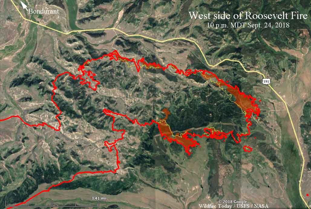
map Roosevelt Fire
Map of the east side of the Roosevelt Fire. The red line was the perimeter at 10 p.m. MDT on September 24. The red shaded areas indicate intense heat. The white line was the perimeter about 24 hours before. Click to enlarge.

The fire grew by approximately 1,500 acres Monday to bring the total up to 49,805 acres. This was a smaller increase than in recent days, with most of the growth occurring on the east side where the perimeter roughly parallels Highway 189/191.


(Originally published at 6:27 p.m. MDT September 24, 2018)

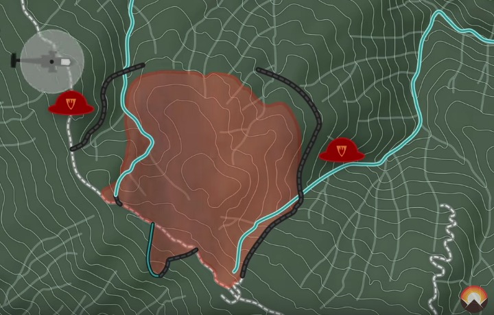
Firefighters on the Roosevelt Fire 30 miles south of Jackson, Wyoming are attempting to fight fire with fire. Their goal Monday through Wednesday of this week is to use a backfire on the southwest side of Highway 189/191 to burn off the vegetation ahead of the fire, hoping it will serve as a barrier as the main fire spreads into the already burned vegetation.

On Monday it was a very difficult task, with 10 to 12 mph winds out of the west and northwest gusting at 20 to 26 mph. These conditions could increase the chance of spot fires across the highway from burning embers lofted by the strong winds.

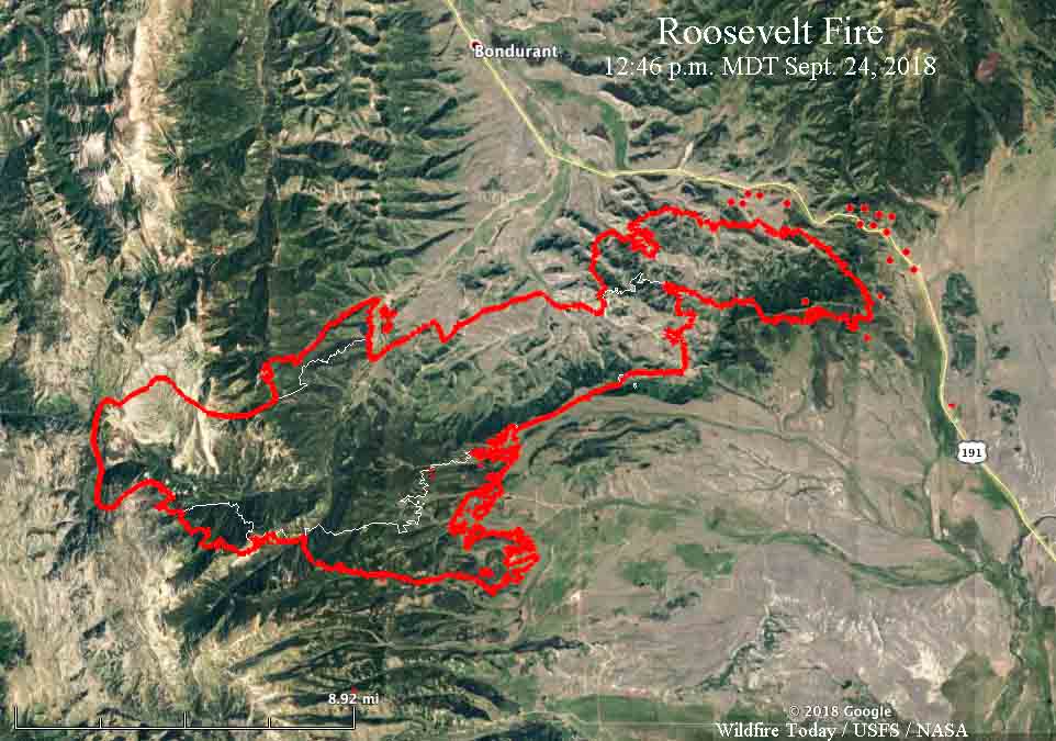
map Roosevelt Fire
Map of the Roosevelt Fire. The red line was the perimeter at 9:20 p.m. MDT on September 23. The white line was the perimeter on Sept. 19. The red dots near Hwy. 189/191 represent heat detected by a satellite at 12:46 p.m. MDT September 24, 2018.

A Red Flag Warning is in effect for the area until 8 p.m. Monday. For Tuesday through Thursday the wind will decrease significantly. The temperatures will range from the teens at night to the 60’s during the day with little chance of precipitation. Those conditions should give firefighters a chance to make progress against the fire.

The fire is five miles south of Bondurant.

A mapping flight Sunday night at 9:20 determined that the fire had burned 48,348 acres.

217 scientists sign letter opposing logging as a response to wildfires

The House version of the 2018 Farm Bill would expand logging on public lands

One of the favorite responses of some politicians to devastating wildfires is to call for increased logging on public lands. Their reasoning is that having fewer trees will prevent large fires. The fact is that logging does not eliminate forest fires. For example, in a clear cut there is still fuel remaining, especially if the slash is left untreated, which can spread a fire faster than a forested area and can act as spot fire traps with dry, easily ignitable vegetation that is even more susceptible to propagating a fire from airborne burning embers up to a mile away from the main fire.

The House version of the 2018 Farm Bill being considered now would expand logging on public lands in response to recent increases in wildfires. A group of 217 scientists, educators, and land managers have signed an open letter calling on decision makers to facilitate a civil dialogue and careful consideration of the science to ensure that any policy changes will result in communities being protected while safeguarding essential ecosystem processes.

Below is an excerpt from the scientists’ letter:


What Is Active Management and Does It Work to Reduce Fire Activity?

Active management has many forms and needs to be clearly defined in order to understand whether it is effective at influencing fire behavior. Management can either increase or decrease flammable vegetation, is effective or ineffective in dampening fire effects depending on many factors, especially fire weather, and has significant limitations and substantial ecological tradeoffs.

Thinning Is Ineffective in Extreme Fire Weather – Thinning is most often proposed to reduce fire risk and lower fire intensity. When fire weather is not extreme, thinning-from-below of small diameter trees followed by prescribed fire, and in some cases prescribed fire alone, can reduce fire severity in certain forest types for a limited period of time. However, as the climate changes, most of our fires will occur during extreme fire-weather (high winds and temperatures, low humidity, low vegetation moisture). These fires, like the ones burning in the West this summer, will affect large landscapes, regardless of thinning, and, in some cases, burn hundreds or thousands of acres in just a few days. Thinning large trees, including overstory trees in a stand, can increase the rate of fire spread by opening up the forest to increased wind velocity, damage soils, introduce invasive species that increase flammable understory vegetation, and impact wildlife habitat.  Thinning also requires an extensive and expensive roads network that degrades water quality by altering hydrological functions, including chronic sediment loads.

Post-disturbance Salvage Logging Reduces Forest Resilience and Can Raise Fire Hazards – Commonly practiced after natural disturbances (such as fire or beetle activity), post-disturbance clearcut logging hinders forest resilience by compacting soils, killing natural regeneration of conifer seedlings and shrubs associated with forest renewal, increases fine fuels from slash left on the ground that aids the spread of fire, removes the most fire-resistant large live and dead trees, and degrades fish and wildlife habitat. Roads, even “temporary ones,” trigger widespread water quality problems from sediment loading. Forests that have received this type of active management typically burn more severely in forest fires.

Wilderness and Other Protected Areas Are Not Especially Fire Prone – Proposals to remove environmental protections to increase logging for wildfire concerns are misinformed. For instance, scientists recently examined the severity of 1,500 forest fires affecting over 23 million acres during the past four decades in 11 western states. They found fires burned more severely in previously logged areas, while fires burned in natural fire mosaic patterns of low, moderate and high severity, in wilderness, parks, and roadless areas, thereby, maintaining resilient forests.

Consequently, there is no legitimate reason for weakening environmental safeguards to curtail fires nor will such measures protect communities.

Closing Remarks and Need for Science-based Solutions

The recent increase in wildfire acres burning is due to a complex interplay involving human-caused climate change coupled with expansion of homes and roads into fire-adapted ecosystems and decades of industrial-scale logging practices. Policies should be examined that discourage continued residential growth in ecosystems that evolved with fire. The most effective way to protect existing homes is to ensure that they are as insusceptible to burning as possible (e.g., fire resistant building materials, spark arresting vents and rain-gutter guards) and to create defensible space within a 100-foot radius of a structure. Wildland fire policy should fund defensible space, home retrofitting measures and ensure ample personnel are available to discourage and prevent human-caused wildfire ignitions. Ultimately, in order to stabilize and ideally slow global temperature rise, which will increasingly affect how wildfires burn in the future, we also need a comprehensive response to climate change that is based on clean renewable energy and storing more carbon in ecosystems.

Public lands were established for the public good and include most of the nation’s remaining examples of intact ecosystems that provide clean water for millions of Americans, essential wildlife habitat, recreation and economic benefits to rural communities, as well as sequestering vast quantities of carbon. When a fire burns down a home it is tragic; when fire burns in a forest it is natural and essential to the integrity of the ecosystem, while also providing the most cost effective means of reducing fuels over large areas. Though it may seem to laypersons that a post-fire landscape is a catastrophe, numerous studies tell us that even in the patches where fires burn most intensely, the resulting wildlife habitats are among the most biologically diverse in the West.

For these reasons, we urge you to reject misplaced logging proposals that will damage our environment, hinder climate mitigation goals, and will fail to protect communities from wildfire.

Comparing the numbers of human and lightning caused wildfires

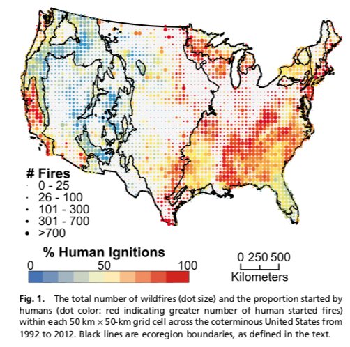
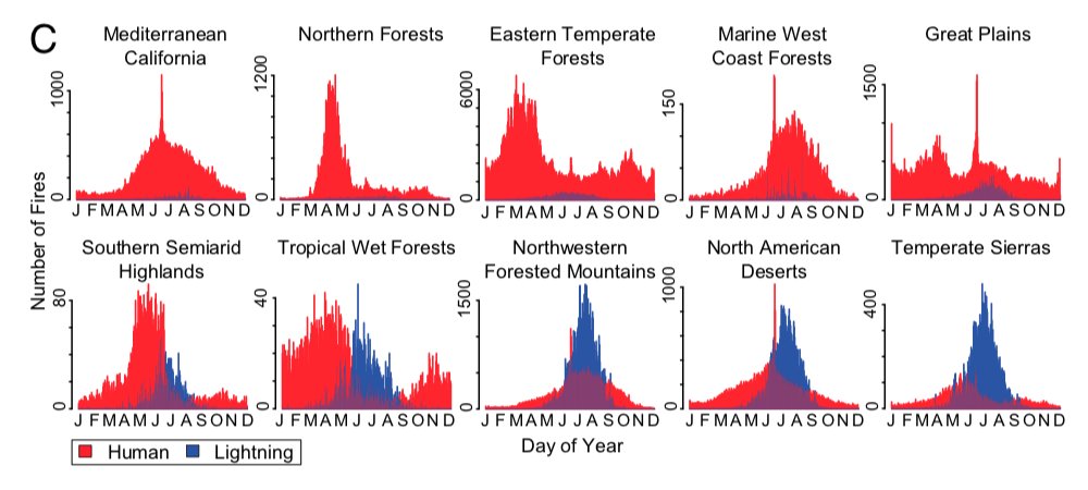
During a 21-year period 84 percent of the wildfires in the United States were caused by humans, but the ratio varies greatly across the country.

lighting human caused wildfires

A study published by the National Academy of Sciences looked at the causes of wildland fires, human vs. lightning, and their occurrence geographically and seasonally. The researchers analyzed 1.5 million fire occurrence records from 1992 to 2012.

I was interested in reading the paper after having been attracted to the compelling graphics comparing the numbers of fires caused by humans and lighting, ecoregion by ecoregion over time.

The research was conducted by Jennifer K. Balch, Bethany A. Bradley, John T. Abatzogloue, R. Chelsea Nagy, Emily J. Fusco, and Adam L. Mahood.

lighting human caused wildfires
Frequency distributions of wildfires by ecoregions, ordered by decreasing human dominance. Click to enlarge.

You might have noticed a large short-lived spike in the number of human caused fires in several of the ecoregions around June-July. That represents ignitions caused by fireworks on the Fourth of July.

Below is an excerpt from the research:


“In conclusion, we demonstrate the remarkable influence that humans have on modern United States wildfire regimes through changes in the spatial and seasonal distribution of ignitions. Although considerable fire research in the United States has rightly focused on increased fire activity (e.g., larger fires and more area burned) because of climate change, we demonstrate that the expanded fire niche as a result of human-related ignitions is equally profound. Moreover, the convergence of warming trends and expanded ignition pressure from people is increasing the number of large human-caused wildfires. Currently, humans are extending the fire niche into conditions that are less conducive to fire activity, including regions and seasons with wetter fuels and higher biomass.

“Land-use practices, such as clearing and logging, may also be creating an abundance of drier fuels, potentially leading to larger fires even under historically wetter conditions. Additionally, projected climate warming is expected to lower fuel moisture and create more frequent weather conditions conducive to fire ignition and spread, and earlier springs attributed to climate change are leading to accelerated phenology. Although plant physiological responses to rising CO2 may reduce some drought stress, climate change will likely lead to faster desiccation of fuels and increased risk in areas where human ignitions are prevalent.”

(end of excerpt)


You can download the paper HERE (it is a large 13 Mb file).

Winners announced for contest to build deployable device to monitor wildfire smoke

Wildland fires produce significant air pollution, posing health risks to first responders, residents in nearby areas, and downwind communities.

The existing air quality monitoring hardware is large, cumbersome, and expensive, thereby limiting the number of monitoring stations and the data that is available to help officials provide appropriate strategies to minimize smoke exposure. They can’t be easily moved to the latest areas that are being affected by wildfire smoke.

Last year the Environmental Protection Agency in association with the U.S. Forest Service, National Park Service, and other agencies issued a Wildland Fire Sensors Challenge to spur the development of a transportable device that could measure some of the byproducts of combustion produced by vegetation fires. They offered prizes for the first and second place entries of $35,000 and $25,000.

The goal was a field-ready prototype system that could be set up near a fire that was capable of measuring constituents of smoke, including particulates, carbon monoxide, ozone, and carbon dioxide over the wide range of levels expected during wildland fires. It was to be accurate, light-weight, easy to operate, and capable of wireless data transmission, so that first responders and nearby communities have access to timely information about local air quality conditions during wildland fire events.

The winners have been announced:

Sensor Challenge Winners
EPA

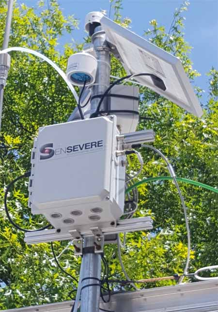
Jason Gu of SenSevere/Sensit, a co-developer of the first place winning system, said they have a number of units in the field now being tested under real world conditions. They also want to install them near existing air quality monitoring stations to ensure that the data from the new design is comparable to data from the old-school stationary equipment that has been used for decades. When they are satisfied with the results, manufacturing will be the next step.

smoke monitor air quality sensors
SenSevere/Sensit

The SenSevere/Sensit unit has a battery that can last for three weeks but will have a solar panel to keep it charged. The device can transmit the data via a cellular connection or a radio. All of the sensors are made by SenSevere/Sensit. Their smoke sensor uses a blower that pulls air through a filter which removes the larger particles, and then a light beam detects the remaining very small PM2.5 particles, the ones that can be ingested deep inside a person’s lungs.

The video below has more information.