Delta Fire adds another 6,000 acres

The fire is 24 miles north of Redding, California. Interstate 5 is now open, one lane in each direction

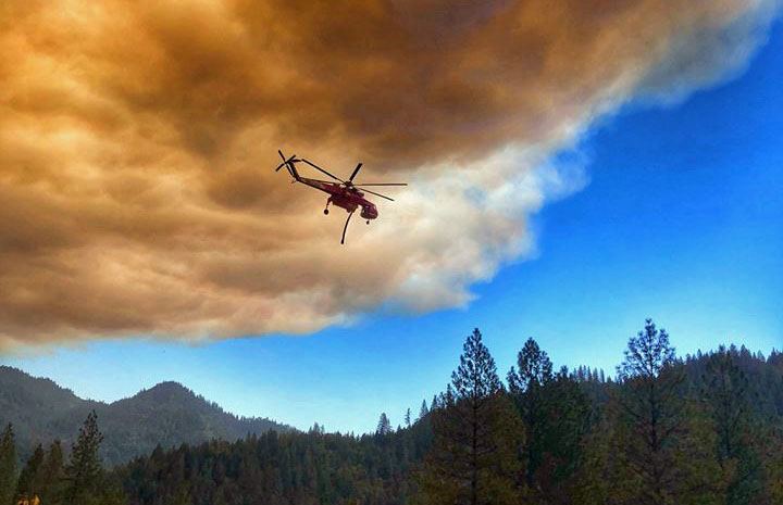
Sikorsky Air-Crane helicopter Delta Fire
A Sikorsky Air-Crane working on the Delta Fire. USFS photo.

(UPDATED at 2:37 p.m. PDT September 10, 2018)

Interstate 5 is now open. Officials reopened the highway Monday morning, with one lane available in each direction through the fire area. The lane restriction is in effect  for 17 miles between Antlers Bridge in Lakehead and Flume Creek Road, south of Dunsmuir, Caltrans said in a statement.


(UPDATED at 8:52 a.m. PDT September 10, 2018)

Firefighters are making progress, slowly, on the 46,150-acre Delta Fire which has forced the closure of Interstate 5 north of Redding, California. Some of the challenges they are facing include very steep, remote terrain and inversions that trap smoke making aerial support difficult or impossible at times.

One of their goals is to contain the spread near the Interstate so that the very important transportation corridor can be reopened. But in addition to that, thousands of hazardous trees near the highway have be evaluated and mitigated and guard rails destroyed by the fire have to be replaced.

On the southeast side of the fire east of the Interstate crews firing out along a dozer line had a setback when the fire spotted across, requiring them to back off and come up with a modified plan. The firing operation along a dozer line on the north side of the fire west of I-5 appears to be going well, but slowly due to unfavorable winds.

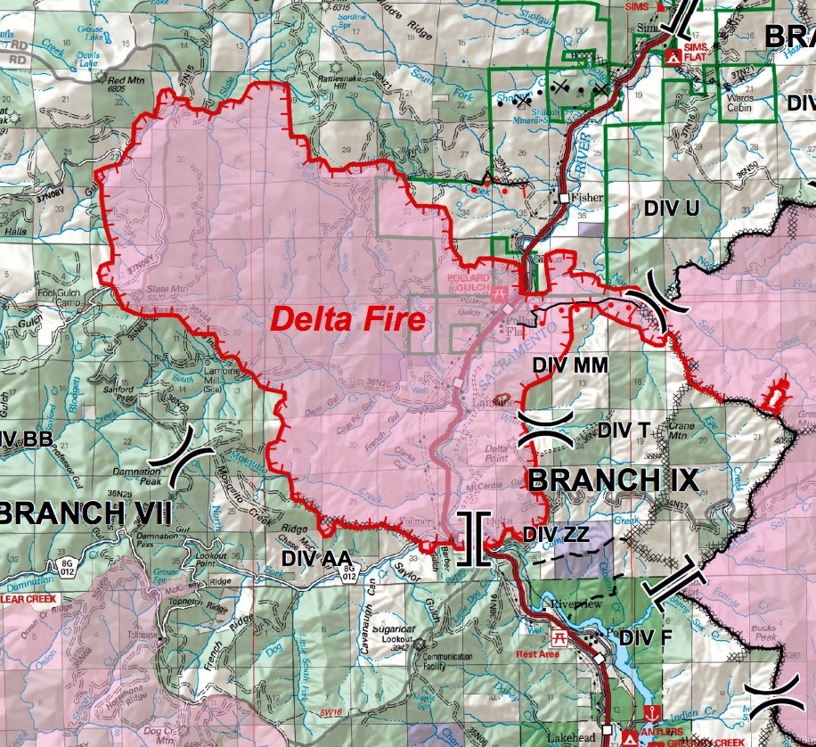
map Delta Fire California Interstate 5
Map of the Delta Fire showing the perimeter (in red) at 12:30 a.m. PDT September 10, 2018. The white line was the perimeter about 24 hours before. The red shaded areas represent intense heat detected by the sensor on the fixed wing mapping aircraft. Click to enlarge.

(UPDATED at 9:55 a.m. PDT September 9, 2018)

Daily inversions have been restricting the growth of the Delta Fire 24 miles north of Redding, California. This atmospheric condition can trap smoke, reduce the visibility for aircraft attempting to drop water or retardant on the fire, keep the relative humidity higher than normal, and prevent direct sunlight and strong winds from influencing the fire.

But in spite of the inversion the fire has continued to grow over the last two days along most of the perimeter, adding thousands of acres each day. A mapping flight Saturday night determined that almost 4,000 acres had burned since the previous night bringing the total up to 40,580.
3-D Delta Fire Map
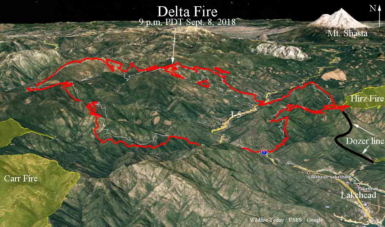
A 3-D map of the Delta Fire looking north, showing the perimeter at 9 p.m. PDT September 8, 2018. Click to enlarge.

Firefighters are conducting at least two large firing operations. One of them is 2 miles west of I-5 on the north side of the fire along a 5-mile long dozer line stretching from the Interstate west up to a 6,500-foot ridge. At 9 p.m. Saturday about three-quarters of a mile had been completed on this project.

(To see the all of the articles on Wildfire Today about the Delta Fire including the most recent, click here: https://wildfiretoday.com/tag/delta-fire/)

The other large firing operation is on the southeast side between I-5 and the Hirz Fire. This is proceeding down a dozer line constructed as a contingency line during the battle to contain the Hirz Fire. The dozer line can be seen in black on the map below and the one above.

A 3-D map of the Delta Fire looking west, showing the perimeter at 9 p.m. PDT September 8, 2018. Click to enlarge.

Two spot fires have been growing slowly on the northwest side of the fire southeast of Pond Lily Lake above 5,000′ elevation. They are most likely low priority to deal with, considering that stopping the spread of the fire along Interstate 5 so it can be reopened has to be near the top of the Things To Do list. There is no word on when this major highway will be open to traffic again. About 45 miles of the Interstate are closed.

Evacuations are still in effect for the communities of Delta, Lamoine, Pollard Flat, Sims and Castella. The Trinity County Sheriff’s Office Facebook page has the most current evacuation information.

Two structures have been destroyed, but officials have not specified if they were residences or out buildings. Approximately 2,132 personnel are assigned to the fire.


(UPDATED at 1:14 a.m. PDT September 8, 2018)

The Delta Fire 24 miles north of Redding, California on Friday added another 12,000 acres moving north, south, east, and west through the Shasta-Trinity National Forest. Overnight mapping determined that the fire has burned almost 37,000 acres.

Shortly after it started on September 5 it crossed and forced the closure of Interstate 5, the main north-south highway in Northern California.   It continued to spread east and has merged with the 46,000-acre Hirz Fire. The two fires now share a two-mile long section of their perimeters. Unless the weather changes, that sharing is likely to increase especially on the southeast side of the Delta Fire north of Lakehead where there is the potential to have another 5 miles of common fire edge.
Delta fire
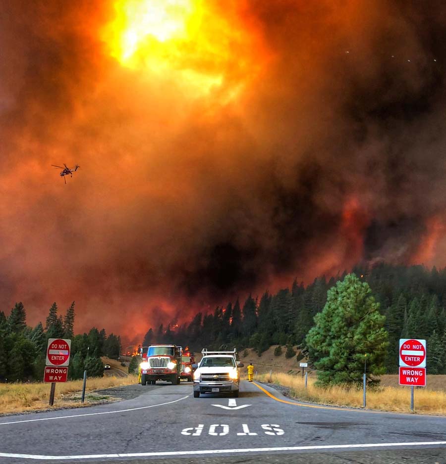
DO NOT ENTER. InciWeb photo.

Multiple commercial vehicles and several structures have been damaged or destroyed.

Continue reading “Delta Fire adds another 6,000 acres”

Report on dozer rollover on the Carr Fire in Northern California

CAL FIRE has released a “Green Sheet” report on the accident that occurred August 1, 2018

The California Department of Forestry and Fire Protection (CAL FIRE) has released a Green Sheet report about the rollover of a dozer that occurred August 1, 2018 on the Carr Fire west of Redding, California.

Below are excerpts from the 14-page report:

“At approximately 7:00 AM on Tuesday, July 31, 2018, two CWN bulldozers (DOZ1 and DOZ2) were 24 hour resources assigned to Branch III, Division D on the Carr incident. DOZ1’s operator (OP1) had been assigned to the same area on the previous 24-hour operational period (south of HWY 299E on County Line Road) and worked the night shift (7:00 PM to 7:00 AM). OP1 had 4 years of bulldozer operating experience and at least 17 years in the logging industry. OP1 had used the bulldozer extensively in Sonoma and Napa counties in the Fall of 2017.

[…]

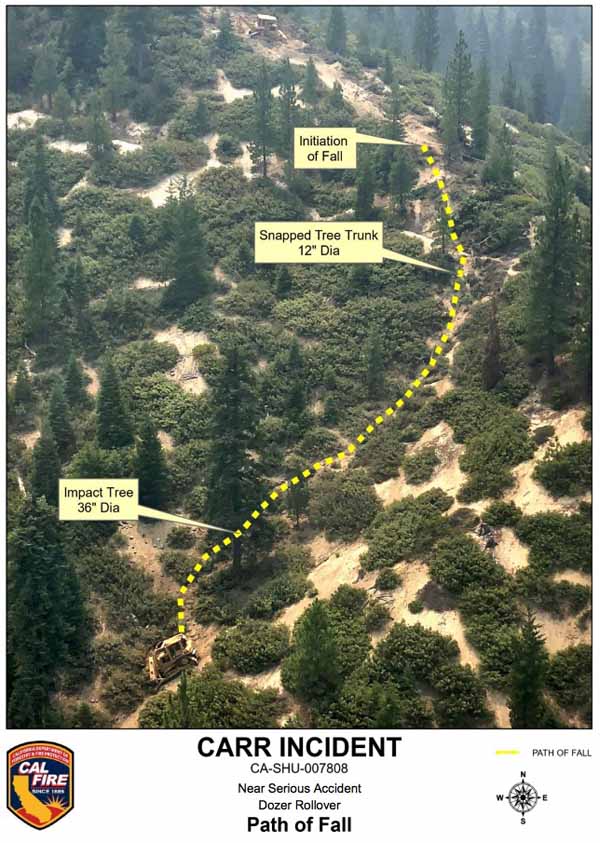
“At approximately 12:30 AM, STL1 looked toward DOZ1, located up the spur ridge and observed DOZ1 close to the steeper east aspect of the spur ridge. From STL1’s vantage point, DOZ1 was facing him and appeared to be tilted to the right at approximately 40-45 degrees. STL1 observed DOZ1 attempt to climb back to the center of the spur ridge in reverse. While DOZ1 backed, STL1 further observed the front of DOZ1 abruptly rotated 90 degrees to the left and the front of the dozer lift into the air. DOZ1 then lost traction and slid backwards downhill, at which time STL1 saw DOZ1 roll twice, end over end, before he lost sight of it down the slope. STL1 could hear DOZ1 continue to roll down the slope, and then stop. STL1 went to the edge of the slope where DOZ1 left the ridgetop, and could see DOZ1 approximately 300 feet downslope.

“At approximately 12:32 AM, STL1 notified Branch II (t) of the accident and his intention to proceed to DOZ1 to ascertain injuries and needs. STL1 contacted DOZ2 to cease operations and then proceeded to DOZ1’s location. Branch II Safety Officer and Division C Fireline Medics responded to the accident site. Carr Communications was notified of the accident at 12:34 AM by Branch II (t).

“While walking downslope to DOZ1, STL1 heard the engine speed fluctuating up and down. STL1 found the dozer upright on its tracks with the cab still intact. STL1 observed movement inside the bulldozer cab. DOZ1 appeared to be stable and STL1 boarded the dozer on the uphill (right) side. The right cab door was jammed and would only open a couple of inches. STL1 contacted OP1 and did a quick visual assessment. OP1 suffered injuries to the head but was alert and oriented.

“At approximately 12:35 AM, STL1 updated Branch II (t) of OP1’s condition via radio. Branch II (t) advised STL1 to follow the “Incident Within an Incident” protocol in the Incident Action Plan. OP1 self-extricated through the left cab door. With OP1 sitting on the ground, STL1 performed a thorough secondary patient assessment. A night hoist capable helicopter was requested due to mechanism of injury, patient location, and extended ground transport time to a medical facility. A California National Guard night vision equipped 24-hour helicopter medivac resource, assigned to the incident, responded from Redding Helibase and an Advanced Life Support ground ambulance was dispatched to Hwy 299E and County Line Road (Buckhorn Summit) from their staging area in west Redding.

“Division C Fireline Medics arrived at the accident site at 1:35 AM. Due to a heavy smoke inversion, the helicopter experienced difficulty accessing the accident site and at 2:01 AM, Division C Medics cancelled the helicopter and walked OP1 out to meet the ground ambulance. OP1 was transferred to the ALS ambulance at 2:43 AM and began transport to Mercy Medical Center with a 2-hour estimated time of arrival…”

Carr Fire Dozer Rollover California
The rollover path of the dozer accident on the Carr Fire, August 1, 2018. Image from the CAL FIRE Green Sheet.

Forest Service: wildfire smoke is “bad for your health”

Above: The Cottonwood Fire west of Chadron, Nebraska, July 18, 2012. Photo by Bill Gabbert.

The article below was written and published by the U.S. Forest Service. It seems ironic that much of the smoke described comes from fires being fought or “managed” on the agency’s lands, but this article does not address what is being done to mitigate those pollutants being generated. Or what their plans are to protect or even monitor the health of their 10,000 wildland firefighters who are chronically exposed to smoke. Their advice if smoke is a problem? Don’t go outside.


Where there’s fire there’s smoke and it’s bad for your health

By: Robert Westover
USDA Forest Service
Office of Communication
August 24, 2018

Deadly and destructive wildland fires consuming so much of the West, from California all the way to British Columbia, are not only affecting those who have had to flee but those who are downwind of these massive infernos. Smoke from this year’s summer wildfires have delayed air traffic in the Seattle area and even resulted in warnings for healthy adults to stay inside.

Smoke-related health symptoms include scratchy throat coughing, sinus inflammation, stinging eyes and runny nose and sometimes headaches. And, according to the CDC, exposure to wildland fire smoke can cause chest pain, a fast heartbeat or wheezing or bring on an asthma attack. Sometimes those with heart disease may experience chest pain, irregular heartbeats, shortness of breath and fatigue.

At one point, in early July, before the prevailing winds helped de-choke Washington state, Seattle was reported to have the worst air quality in the nation. Colorado wasn’t spared as smoke from Canadian blazes blocked the view of the Rocky Mountains throughout the Denver metro area. In the San Francisco Bay area, smoke from wildfires on Forest Service managed lands north of the bay forced authorities to issue a rare air quality advisory. They even suggested people not drive to limit additional pollutants in the air and advised those with certain health issues, like asthma, to stay inside. And in Portland, Oregon, public schools suspended outdoor sports activities.

Wildland fire smoke includes particles from not only burning trees and grasses but also chemicals from buildings mixed with gases. So if your eyes feel like they’re stinging, smoke exposure could also be inflicting other damage as particles could be getting into your respiratory system.

So what do you do to avoid health issues caused by poor quality air from wildfires?

Heed the advice of authorities and stay inside once a smoke alert has been issued. Also if you see or smell smoke from wildfire in your area or a place you plan to visit, check the national Air Quality Index website to see if you should stay inside.

Delta Fire, updated information, September 7, 2018

The blaze north of Redding, California has grown to 24,558 acres

Delta Fire Map
Delta Fire. Map by Incident Management Team, released Friday morning, Sept. 7. Click to enlarge.

Fire officials said Friday morning that the Delta Fire 24 miles north of Redding, California has grown to 24,558 acres, an increase of more than 2,000 acres since Thursday.

While the fire is steadily growing, it is moving at a much slower rate than it did the day it started, Wednesday, when it burned over 15,000 acres in the first nine hours.

(To see the all of the articles on Wildfire Today about the Delta Fire including the most recent, click here: https://wildfiretoday.com/tag/delta-fire/)

On Thursday firefighters were working on a firing operation on the east side of the fire that would tie it in with the 46,000-acre Hirz Fire, checking the spread on the east side of Interstate 5 and keep it from moving farther north in that area. At 2:24 a.m Friday a satellite detected a lot of heat in that area, so it is uncertain if they were successful.

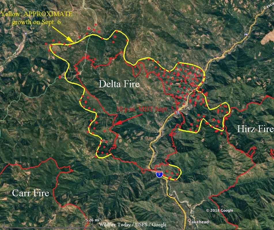
The map above was released by the incident management team Friday morning; the date and time of the data used to map the perimeter is unknown. The satellite passing 200 miles above the fire at 2:24 a.m Friday  detected heat one or two miles farther north along both sides of Interstate 5, which is still closed, reaching almost as far north as the off ramp at Fisher (see the map below).

Delta Fire Map
Map of the Delta Fire. The red line was the perimeter mapped by a fixed wing aircraft at 10 p.m. MDT Sept. 5. The yellow line is the APPROXIMATE growth since then based on heat detected by satellites at 2:24 a.m. PDT September 7 (the red dots) and before. Click to enlarge.

There was no overnight mapping by a fixed wing aircraft Thursday night. One of the two U.S. Forest Service infrared scanning planes was down with mechanical difficulties, which could be the reason for the “unable to fill”. It was smoky over the fire during the night but that usually does not prevent imaging the fire, unlike clouds which prevent the infrared light from reaching the sensor on the aircraft. The ability to “see” through smoke is one of the primary attributes of infrared sensing technology. However an intense convection column containing smoke, ash, and burning embers can be confused with heat on the ground.

During the large vegetation fires in southern California in 2003 some of the convection columns were so powerful that the windshields on six air tankers were cracked by chunks of debris that were being hurled into the air (page D-6 in 2003 California Governor’s Blue Ribbon Report; huge 20 Mb file). One pilot saw a four by eight sheet of plywood sail past at 1,500 feet.

Water tender rollover on the South Umpqua Complex

It occurred July 26, 2018

In searching for a report about the rollover of a dozer transport, I ran across this very brief “24-hour preliminary report” about a water tender rollover. It occurred July 26, 2018 on the South Umpqua Complex on the “Umpqua National Forest and Medford BLM”. There is no indication that a Rapid Lesson Sharing report is being prepared.

Below is the text from the report, dated July 27, 2018:


Location: South Umpqua Complex, Umpqua National Forest and Medford BLM
Date of Occurrence: July 26, 2018
Time of Occurrence: Approximately 2400
Activity: Wildland Fire Suppression
Number of Injuries: 0
Number of Fatalities: 0
Property Damage: damage to non-federal contract operated water tender
Narrative: A water tender assigned to the South Umpqua Complex Fire was traveling on an unpaved road and rolled backwards off the road resulting in the vehicle rolling on its side. The vehicle came to a rest on the driver’s side. There was only one crew member, that individual was transported back to base camp. There were no injuries.