Wildfire potential September through December

Originally published at 10 p.m. MDT September 1, 2018)
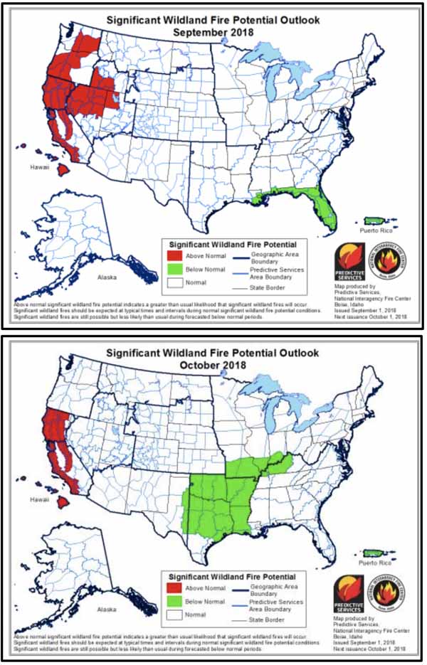
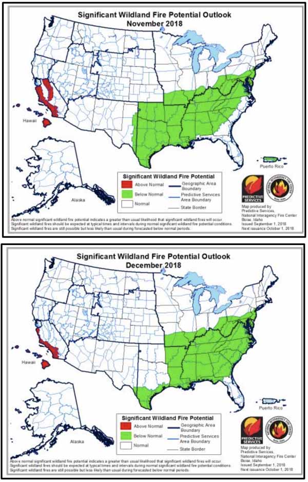
wildfire potential September OctoberOn September 1 the Predictive Services section at the National Interagency Fire Center issued their Wildland Fire Potential Outlook for September through December. The data represents the cumulative forecasts of the ten Geographic Area Predictive Services Units and the National Predictive Services Unit.

If their analysis is correct, in September the wildfire potential will decrease in the Northern Rockies, which is not unusual for this time of the year, but remain elevated in Central Texas, California, Nevada, and the Cascades. For October through December the potential should remain high in Southern California, with no sign of a busier than usual fall fire season in the Southern Great Plains or the Southeast.

Below:

  • An excerpt from the NIFC narrative report for the next several months;
  • NIFC’s monthly graphical outlooks;
  • NOAA’s three-month temperature and precipitation forecasts; and,
  • Drought Monitor.

“The significant wildland fire potential forecasts included in this outlook represent the cumulative forecasts of the ten Geographic Area Predictive Services units and the National Predictive Services unit.

“The western fire season peaked in August as very hot and dry conditions continued under the presence of a very strong, persistent high pressure ridge during the first three weeks of the month. Many approached or broke all-time record highs during the second week of the month. Not surprisingly, many fires became quite large including the Mendocino Complex which burned more than 420,000 acres making it the largest fire on record in California. Most fires observed were in areas of preexisting or developing drought.

“Along the West Coast, drought intensification and expansion was observed across Oregon and Washington. Further inland, abnormally dry conditions developed across Nevada, Idaho, and western Montana. Drought intensification and expansion was also observed across the Great Lakes region. While pockets of extreme to exceptional drought continued across the Four Corner states, the active monsoon was allowing for some improvement to occur. Nearly the entire West Coast received less than 25% of average precipitation. Significant deficits extended inland into the Great Basin and the Northern Rockies where large areas received less than 50% of average precipitation.

“Most of Texas and the central Great Plains received above average precipitation in August. Amounts across Oklahoma, Kansas, and Arkansas received 200% to 400% of average precipitation. The East Coast received similar amounts. Temperatures nationwide were generally near to slightly above average except across the central Great Plains where they were a few degrees below average. Alaska fully exited the season mid-month as a wet and cool patter took hold across the Interior. Hawaii experienced large fire activity as well; however, the heavy rains from Hurricane Lane quickly reduced fire potential across the state.

“September is a transitional month for the West. Critical fire weather periods become increasingly driven by occasional wind events resulting from passing cold fronts or by a strong westerly flow. The transition this year began a few weeks early. A shift to a fall-like pattern began the last week of August. Overall normal significant large fire potential is expected in most areas across the West except along the Canadian border with northeastern Washington, extreme northern Idaho, and northwestern Montana where above normal potential is expected. Debris from Hurricane Lane may produce heavy dead fuel loadings across Hawaii which could become receptive should abnormally dry conditions develop. Portions of northwestern Nevada and northeastern California could remain elevated as well given continued fuel dryness and a propensity for wind events.

“In October, the continued seasonal transition into fall will allow for colder air to become entrenched across the Great Basin thus creating a high pressure ridge that should periodically induce Foehn Wind events across both Northern and Southern California. Other regions across the Westshould fully exit fire season. In the East, preexisting drought conditions across the Great Lakes Region cloud promote wind-driven events should the fuels remain dry after leaf drop. The remainder of the East is largely free of drought entering late fall.

“November and December are traditionally months where fire activity is reduced. The focus during this period generally shifts from California to the Southeast where during dry years, significant fire activity can be observed. Latest data suggests that the late fall period will experience at least average conditions if not wetter than average conditions in some locations. So, Normal Significant Large Fire Potential is expected across most of country during the remainder of the outlook period.”

wildfire potential November December

Continue reading “Wildfire potential September through December”

Britania Mountain Fire grows to over 27,000 acres

The fire is 8 miles northwest of Wheatland, Wyoming

britania fire wyoming
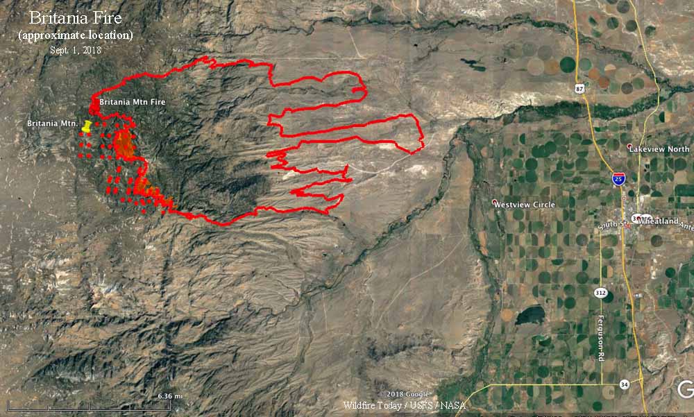
Britania Mountain Fire. The red dots represent heat detected by a satellite at 1:54 a.m. MDT September 1, 2018. The red shaded areas were areas of intense heat detected by a fixed wing aircraft overnight, exact time unknown. The red line was the perimeter at the time of the fixed wing flight. Click to enlarge.

(Originally published at 7:34 a.m. MDT September 1, 2018)

The Britania Fire continues to spread on the west and southwest sides near the peak of Britania Mountain and areas south and southeast of the peak. The Incident Management team reports that it has burned 27,200 acres.

On Thursday firefighters were successful in constructing fireline to gain additional containment on the north side of the fire. On the eastern edge of the fire, crews mopped up and patrolled established containment line constructed over prior shifts.

(To see all of the articles on Wildfire Today about the Britania Mountain Fire, including the most recent, click HERE.)

The southeastern corner of the fire increased containment as crews were successful in constructing direct fireline in the lighter fuels as well as using roads as indirect firelines to conduct firing operations along Palmer Canyon Road. Firefighters used both fixed wing air resources and helicopters to support ground personnel in these efforts. On the southwest corner of the fire, crews identified roads that may be utilized as indirect firelines and began prepping those areas to conduct continued firing operations.


Two water tender rollovers

One was on the Miles Fire in Oregon and the other was on the Ferguson Fire in California

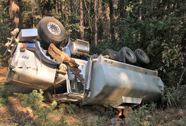
Two water tenders rolled over while working on wildfires in California and Oregon earlier this month. According to the very brief Rapid Lesson Sharing reports filed with the Wildland Fire Lessons Learned Center, there were no serious injuries. No assumptions were made about the cause of either accident, and road conditions were not mentioned as being an issue.

The first occurred on the Ferguson Fire in California August 10, 2018. The brief report can be downloaded here.

water tender rollover Ferguson Fire California
August 10, 2018 rollover of a water tender on the Ferguson Fire in California. Photo from Rapid Lesson Sharing report.

The other rollover occurred two days later on August 12 on the Miles Fire in Oregon. (brief report)

water tender rollover Miles Fire Oregon
August 12, 2018 rollover of a water tender on the Miles Fire in Oregon. Photo from Rapid Lesson Sharing report.

This is one of 51 articles we have written on Wildfire Today about rollovers of vehicles on wildland fires. They occur far too often.

It is not always possible to point to a single cause of many of these sometimes fatal accidents. But challenges facing drivers of emergency vehicles on wildland fires include visibility due to smoke or dust, long hours leading to fatigue, low standard or inadequately maintained roads, distractions, skills needed to drive a large heavy vehicle, top-heavy vehicles, weights exceeding manufacturer’s GVW rating, and shifting of weight caused by partial loads of water in the tank.

Of the 440 fatalities on wildland fires from 1990 through 2014, 22 percent were related to vehicle accidents.

The Rapid Lesson Sharing report for the accident on the Miles Fire reached this conclusion:

Statistics show that the biggest risk to firefighters today is the mundane task of driving to and from the worksite. Often, the function of driving is accompanied by fatigue from the day’s events and thoughts of what is yet to come.

Water Tender operators are asked to drive large, heavy vehicles in variable conditions repeatedly for multiple operational shifts. Just like line firefighters, these professional drivers must fight fatigue and complacency from the beginning of an assignment to its end.

Six firefighters injured escaping from sudden flare up

The six firefighters on the Mendocino Complex of Fires in Northern California had to run for a mile through unburned vegetation when an unexpected wind shift caused explosive fire growth

The following “72-Hour Report” was distributed by the Wildland Fire Lessons Learned Center August 28, 2018 for an incident that occurred August 19, 2018 on the Mendocino Complex of Fires in Northern California.


THE FOLLOWING INFORMATION IS PRELIMINARY AND SUBJECT TO CHANGE

Location: Ranch Fire, Mendocino Complex, east of Ukiah, CA
Date of Occurrence: Sunday, August 19, 2018
Local Agency Administrator: Ann Carlson, Mendocino Forest Supervisor
Activity: Wildland Fire Suppression
Number of Injuries: 6
Number of Fatalities: 0
Property Damage: Radios, packs, 2 vehicles with paint blistering.

SUMMARY

On August 19, 2018, six firefighters received injuries when the fire crossed the dozer line in multiple locations and cut them off from their planned egress. At the time of the incident, firefighters were en-gaged in firing operations off a dozer line near the division break between Hotel and Juliet on the Ranch Fire of the Mendocino Complex.

CONDITIONS

Information from RAWS nearby around the time of this incident, showed temperatures at 93.3 Fahren-heit, RH 11.3%, and winds at 6.6 mph with gusts to 13.3 mph.

NARRATIVE

The Mendocino Complex consisted of the Ranch and River fires that started on July 27th. The fires experienced significant growth during the first ten days, growing 30,000 acres on August 3rd, 40,000 acres on August 4th and 50,000 acres on August 5th. Up until August 19th, the fire growth had been steadily moving both south/southeast and north/northeast. Most days experienced warming and drying trends with very poor recoveries and critically low fuel moistures and afternoon relative humidities near single digits. Steep terrain, poor ventilation, fire intensities and long travel times made it difficult to insert crews and utilize aircraft in certain areas of the fire.

On August 19th, the plan for the fire’s northeast flank was to secure dozer line north of DP25 near the division break in Branch II with a firing operation. Resources from other divisions were brought over to help with the operations. These resources included federal and local fire resources and strike teams from the Los Angeles Fire Department and CAL FIRE. After arriving near the drop point, the personnel staged their engines and vehicles, reconfigured, and were split into two modules to support burning operations and hold the line along a Forest Service road and the dozer line.

During the burnout operations, a sudden wind shift and explosive fire growth happened and at about 1733, personnel were cut off from their escape routes. Most of the firefighters were able to move back to their vehicles to exit the area. However, six individuals farther down the dozer line were forced to run in front of the advancing flame front, through unburned fuels to a nearby dirt road for approximately one mile before they were picked up and transported for treatment. Five Los Angeles Fire Department firefighters and one CAL FIRE firefighter were injured. Two unoccupied CAL FIRE emergency crew transports parked in the vicinity sustained damage from the fire when it jumped containment lines.

Injuries include 1st and 2nd degree burns and a dislocated shoulder.

Britania Mountain Fire spreads south toward Palmer Cyn. Road

The fire has burned 24,105 acres west of Wheatland, Wyoming

Map of the Britania Mountain Fire
Map of the Britania Mountain Fire as of 6:30 p.m. MDT August 29, 2018. Map produced by Incident Management Team. Click to enlarge.

The 24,105-acre Britania Mountain Fire 8 miles west of Wheatland, Wyoming was active Wednesday, influenced by 8 to 15 mph winds out of the west gusting up to 25 mph in the afternoon. The temperature reached 87 degrees at a weather station in Wheatland with 11 percent relative humidity, conditions that kept the fire spreading on the south side and causing a two-mile run to the east between Palmer Canyon and Marble Roads.

(To see all of the articles on Wildfire Today about the Britania Mountain Fire, including the most recent, click HERE.)

The maps produced by the incident management team show the fire up against the north side of Palmer Canyon Road. This could be in part due to firefighters igniting along the road to remove the fuel between the road and the main fire, hoping to stop the fire in that area.

During a satellite overflight at 2:34 a.m. MDT Friday the only large heat sources detected from 200 miles up were on the south side, primarily north of Palmer Canyon Road west of the Albany/Platte County line.

The map below shows previous fires in orange. The fires to the north were the Arapaho and Cow Camp Fires of 2012, while the one to the south was the 2002 Reese Fire. These blazes, especially the ones six years ago, could slow the spread of the Britania Mountain Fire if it reaches those areas — or at least there would be less resistance to control.

Map of the Britania Mountain Fire
Map of the Britania Mountain Fire as of 6:30 p.m. MDT August 29, 2018. The red line is uncontrolled fire edge; the black line is completed fireline; the orange areas are previous fires. Map produced by Incident Management Team. Click to enlarge.

Very little official information has been released about the fire since it started on August 26, but a Type 2 Incident Management Team assumed command Friday morning so that could change. Already we have seen a plethora of new maps.

All of Wyoming except for the northwest portion is under a Red Flag Warning again Thursday. The forecast for the fire area calls for 90 degrees, 11 percent relative humidity, and 8-13 mph winds out of the west and southwest gusting up to 18 mph. Conditions should moderate somewhat on Friday.

The predicted weather will keep cities to the east under a possible threat of dense smoke. Areas in Wyoming that could be affected, depending on the exact wind direction, include Wheatland, Guernsey, and Torrington. Cities in Nebraska that could experience smoke are Mitchell, Scottsbluff, Chadron, and Alliance.

Britania Mountain Fire
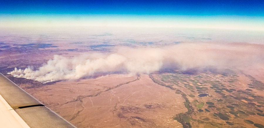
Photo by Nate Mezera @NateMez_turf as he flew over the Britania Mountain Fire August 29. Looking north. Wheatland, WY is under the smoke.


The Northern Rockies Fire Cache – A firefighting megastore

Above: Northern Rockies Fire Cache at Missoula. USFS photo.

(Originally published at 5:20 p.m. MDT August 29, 2018)

From adapters for everything imaginable to wrenches in all sizes – the Northern Rockies Fire Cache is a wildland firefighting megastore. When firefighters need equipment, tables, clothing, foot powder, sleeping bags, radios, or even medical supplies they call on the Cache to meet their needs.

Located in Missoula, Montana, the Northern Rockies Cache serves a wide range of federal, state, local and tribal government agencies within the Northern Rockies Geographical Area, an area of roughly 235,654 square miles.

The Northern Rockies Cache is capable of immediately supplying up to 5,000 firefighters and more than 30 major wildland fires. Support is sustained with a steady flow of replacement supplies from vendors and other Caches.

The Cache is moving toward becoming a minimal waste facility. Every piece of equipment returned to the Cache from a fire is assessed to see if it can be fixed, repaired, or refurbished. If it can, it is cleaned and repaired in-house saving considerable taxpayer dollars. If the equipment is beyond repair it gets recycled if possible. Last year alone the Cache recycled over 22,000 pounds of steel and almost 11,000 pounds of batteries.

Following the 2017 wildland fire season, the Cache inspected, laundered, and repaired over 40,000 pieces of Nomex clothing and over 9,000 sleeping bags. Working through this amount of laundry involves a lot of people – clothes and sleeping bags are inspected when they return from the fireline, sent to local businesses to be laundered, separated by size and condition, and those items needing a little TLC are set aside to be worked on during the winter months. Smokejumpers, known for their elite firefighting skills are also known for their sewing abilities and are called on during the winter to repair Nomex clothing so it can be used again the next season.

How does it work? When a fire burns for a number of days it quickly surpasses the local unit’s ability to provide needed supplies and provisions. Fire managers will place orders for the things they need to the Cache which quickly assembles and ships the supplies. When the fire no longer needs the supplies they return them to the Cache to be cleaned, refurbished and restocked. This includes the miles of hose that has to be pressure tested, cleaned to remove any aquatic hitchhikers (aquatic invasive species), dried, and finally rolled and stacked. Following the 2017 fire season over 1,200 miles of hose (enough hose to reach from Missoula to Long Beach, CA) went through this process.

fire cache at the National Interagency Fire Center
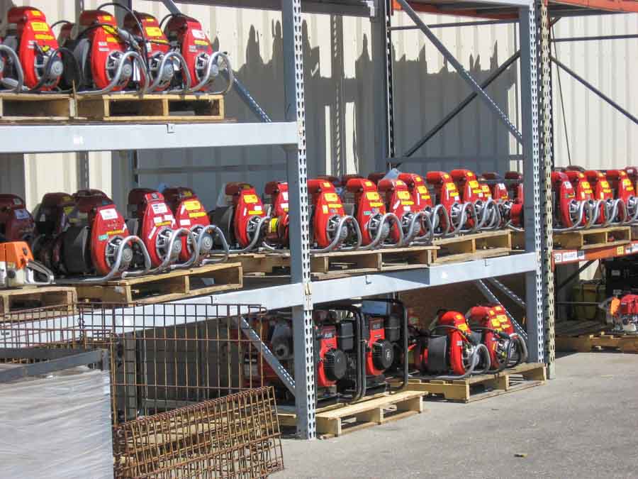
Portable pumps in the fire cache at the National Interagency Fire Center in Boise, ID. BLM photo.

A few Cache figures from the 2017 fire season: 1,300 pumps cleaned and refurbished (the last pump was put back on the shelf ready for the 2018 fire season in June – a year after the 2017 fire season began); almost 400 chainsaws, over 8,200 fire tools, almost 3 million pairs of earplugs, almost 300 pounds of foot powder, over 1.2 million AA batteries; and 64,420 MREs (meals ready to eat) which is enough to feed one person, three meals a day for 58.8 years.

Although its primary focus is to support fire suppression activities in northern Idaho, Montana, and North Dakota (referred to as the Northern Rockies Geographical Area), the Northern Rockies Cache may also lend support to any type of emergency incident in every part of the country. Beginning in the late 1990s, this helping hand and support was extended to include Canada, Mexico and Puerto Rico.

This Cache’s staffing operation consists of 15 people year round and up to 50 during the summer. This highly skilled workforce has met the needs of firefighters across the nation for the last 3 years with no serious accidents.