Carr Fire: threat to Lewiston increases, Redding area improves

The fire has destroyed 1,018 residences near Redding, California

(UPDATED AT 8:54 a.m. PDT August 1, 2018)

Tuesday the Carr Fire, west of Redding, California, was active on the southwest, west, and north sides, to bring the total blackened acres up to 121,000, according to a mapping flight Tuesday night.

CAL FIRE has updated the number of structures impacted by the fire. Destroyed were 1,018 residences, 12 commercial structures, and 435 outbuildings. Buildings damaged included 181 residences, 6 commercial structures and 61 outbuildings.
map carr fire redding california
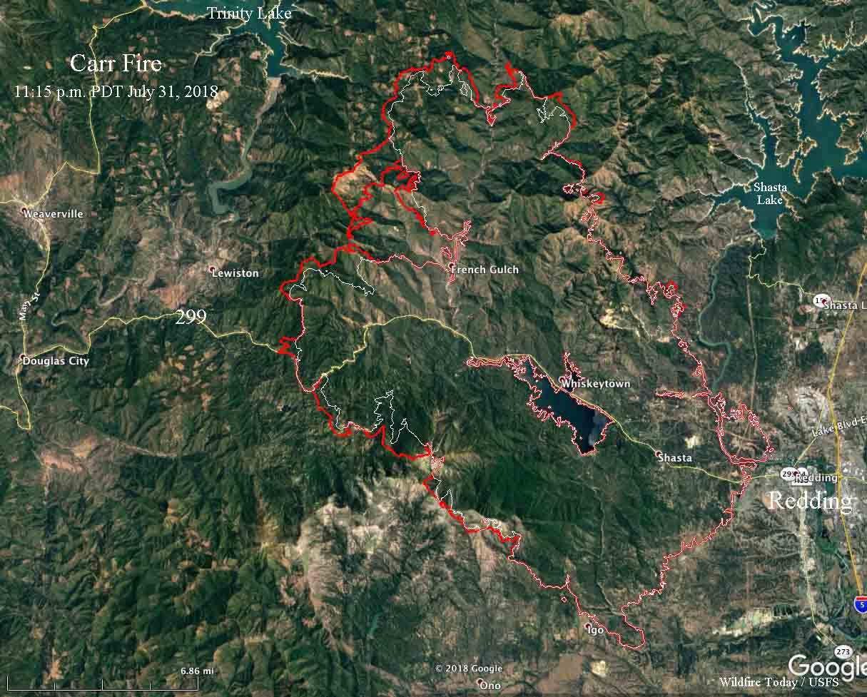
Map showing the perimeter of the Carr Fire, the red line, at 11:15 p.m. PDT July 31, 2018. The white line was the perimeter 27 hours before. Click to enlarge.

To see all of the articles on Wildfire Today about the Carr Fire, including the most recent, click here.


(Originally published at noon PDT July 31, 2018)

Firefighters have made a great deal of progress on the Carr Fire, resulting in no appreciable growth during the last two days within seven miles of the west edge of Redding.

On Sunday and Monday the west side of the fire saw significant expansion from the area west of Shasta Bally Road going clockwise around the west and north sides to a point 4 miles west of Shasta Lake. The fire is 3 miles east of Trinity Lake and 4 miles east of Lewiston. At a Tuesday morning briefing officials said there is “a direct threat to Lewiston”. CAL FIRE is calling it 110,154 acres.
map carr fire
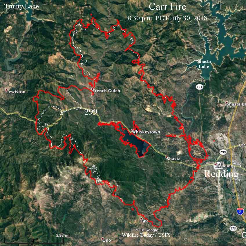
Map showing the perimeter of the Carr Fire at 8:30 p.m. PDT July 30, 2018. The white line was the perimeter two days before. Click to enlarge.

According to the latest information, the number of structures destroyed includes 884 residences, 4 commercial structures, and 348 outbuildings. At least 2,546 remain threatened.
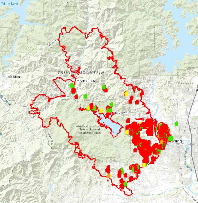
map structures destroyed carr fire redding california
To see an interactive, zoomable CAL FIRE map showing the locations of destroyed and damaged structures on the Carr Fire, CLICK HERE.

The Sheriff’s office confirmed that another fatality has been found on the Carr Fire, bringing the total up to six. The latest was a 60-year old man who recently had heart surgery. Other deaths include two firefighters, and a great grandmother and two grandchildren she was caring for. Another seven people have been reported missing.

Many areas have been repopulated, but others are still under evacuation orders.

Helicopters and air tankers have been prevented at times from dropping water and retardant on the fire by an inversion that traps smoke, at times decreasing the visibility to a point where it is unsafe for the aircraft to fly as required, low and slow over complex terrain.

Resources assigned to the fire include 334 fire engines, 59 hand crews, 17 helicopters, 68 dozers, and 65 water tenders, for a total of 3,607 personnel.

Firefighters on the Mendocino Complex battle to protect structures around Clear Lake

The fires are threatening 10,200 structures near Upper Lake and Lakeport, California

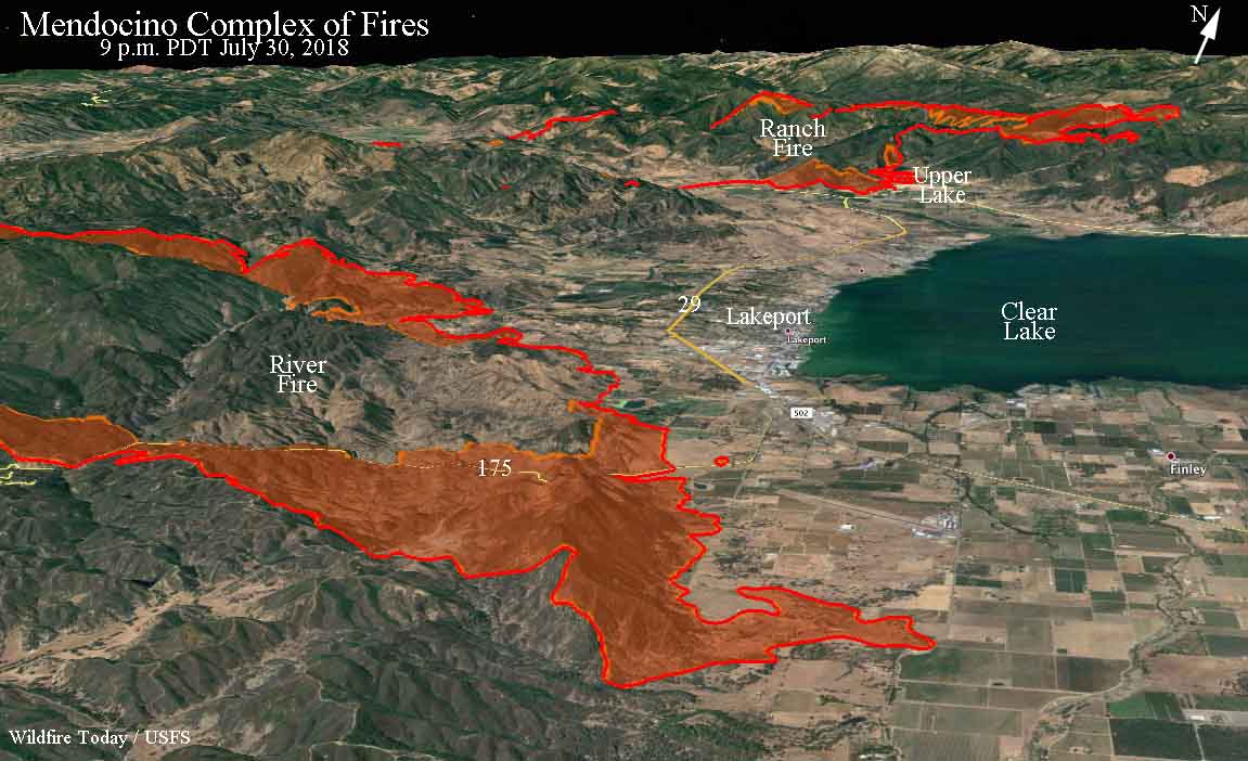
Above: Map of the Mendocino Complex of Fires. The red line was the perimeter at 9 p.m. PDT July 30, 2018. The white line was the perimeter about 24 hours earlier. The red shaded areas represent intense heat.

(Originally published at 5:02 a.m. PDT July 31, 2018)

Firefighters working on the two wildfires in the Mendocino Complex of Fires near Clear Lake east of Ukiah, California are not only battling two fires spreading aggressively near populated areas, they are also competing with numerous other large fires in California and the rest of the United States. With 140 large fires burning, every one needs resources, and not all incident commanders are receiving the numbers of crews, engines, dozers, air tankers, helicopters, and overhead personnel that they have requested.

Of the 25,632 firefighters that have been mobilized in the U.S., the 68,000-acre Mendocino Complex, comprised of the Ranch and River Fires, has obtained almost 2,000 personnel, including 205 fire engines, 38 hand crews, 12 helicopters, 45 dozers, and 43 water tenders.

map Mendocino Complex Fires
3-D map of the Mendocino Complex of Fires. The red line was the perimeter at 9 p.m. PDT July 30, 2018. The red shaded areas represent intense heat at that time.

Seven residences have been destroyed on the two fires and another 12,200 remain threatened.

The Ranch Fire, just north of Upper Lake, has burned about 45,000 acres. So far firefighters have kept it out of the main part of the community and mostly west of Middle Creek near the town. There has been one slop over south of Highway 20 three miles west of the Highway 20/29 intersection.

The 23,000-acre River Fire turned southeast Monday, skirting around Lakeport and Finley as it burned across Highway 175.

Firefighter killed on Ferguson Fire identified

The National Park Service has identified the firefighter who was killed Sunday morning July 29 while battling the Ferguson Fire on the Sierra National Forest in California west of Yosemite National Park. It was Captain Brian Hughes of the Arrowhead Hotshots.

The incident occurred just before 9:30 a.m.  Captain Hughes and his crew were engaged in a tactical firing operation on the east side of the fire. In  an area with a large amount of tree mortality, he was struck by a falling tree. Captain Hughes was treated at the scene, but passed away before he could be transported to a hospital.

Captain Brian Hughes
Captain Brian Hughes. Photo courtesy of Brad Torchia.

Mendocino Complex of Fires grows closer to communities around Clear Lake

The two large fires are threatening Lakeport and Upper Lake, California

(Originally published at 7:04 a.m. PDT July 30, 2018)

The Ranch and River Fires that comprise the Mendocino Complex of Fires were very active again Sunday.

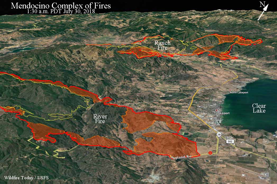
The northernmost of the two fires, the Ranch Fire, spread three to five miles to the east and south and at 1:30 a.m. Monday was less than a mile north of Upper lake. So far firefighters have been able to keep it mostly north and east of Highway 20, but at 1:30 a.m. there was a spot fire across the highway three miles west of Upper Lake.

map Mendocino Complex Fires
3-D map of the Mendocino Complex of Fires. The red line was the perimeter at 1:30 a.m. PDT July 30, 2018. The yellow line was the perimeter 25 hours earlier. The red shaded areas represent intense heat at that time. Click to enlarge.

Farther south, the River Fire grew three miles to the east and at 1:30 a.m. Monday was less than a mile west of the Highway 29/175 intersection near Lakeport. Firefighters are no doubt working hard to keep the fire north of Highway 175, but it had slopped over at one point two air miles southwest of the intersection.

(To see all of the articles on Wildfire Today about the Mendocino Complex of Fire, click HERE.)

Using infrared mapping data our very unofficial estimate of the total number of acres burned in the two fires at 1:30 a.m. PDT on Monday is approximately 55,000. (UPDATE at 7:16 a.m. PDT July 30, 2018: at 7:15 a.m. CAL FIRE updated the size of the fires. They reported the Ranch Fire has burned 35,076 acres, and the River Fire, 20,911, for a total of 55,987 acres.)

CAL FIRE reports that six residences have been destroyed and 10,200 are threatened. The agency also said weather conditions will continue to challenge firefighters as hot, dry and windy conditions persist. A lack of available suppression and overhead personnel will also slow the firefighting efforts, they said.

Mandatory evacuation orders affecting thousands of residents are in place for several locations around the two fires in Lake County. Below is an excerpt from an article in the Lake County News:

The River fire’s approach to the Lakeport, the county seat, and its full evacuation has had numerous impacts, including closure of the Lake County Superior Court, and county and city offices; the evacuation of Sutter Lakeside Hospital and Evergreen Lakeport Healthcare; temporary shuttering of the Lakeport Senior Center; as well as closure of numerous businesses.

The weather forecast for the foothills west of Lakeport for Monday predicts 94 degrees, 18 percent relative humidity, and west or northwest winds of 3 to 9 mph gusting to 13. These conditions are expected to persist through Friday.

Resources assigned to the Complex include 118 fire engines, 22 water tenders, 6 helicopters, 31 hand crews, and 37 dozers for a total of 1,379 personnel.

map Mendocino Complex Fires
Map of the Mendocino Complex of Fires. The red line was the perimeter at 1:30 a.m. PDT July 30, 2018. The yellow line was the perimeter 25 hours earlier. The red shaded areas represent intense heat at that time. Click to enlarge.

Are we experiencing a “new normal” of wildland fire behavior?

In the last 16 days four fighters and at least three civilians have been killed on two fires in California, the Ferguson and Carr Fires.

These two fatal fires that are still spreading have over 7,100 personnel working to put them out. Today, nationally, 24,641 are assigned to wildland fires according to the July 29 National Situation Report, including 584 hand crews and 1,689 fire engines. These are very high numbers that have not been reached very often.

There are risks associated with wildland fires, and the more people taking those risks, almost 25,000 today, the more likely it is that fatalities will occur. Struggling to knock down huge weather and fuel-driven fires, or having people assigned for months to a fire that is being managed with a less than full suppression strategy, exacerbates the situation, exposing more firefighters for longer periods of time.

Firefighters on the Carr Fire near Redding, an area very familiar with wildland fire, are saying that during the current drought and extreme heat, the fire has been spreading without regard to what’s in front of it.

Below is an excerpt from an article at KTVU about the Carr Fire:

“We’re not fighting a fire,” said Jonathan Cox, battalion chief with Cal Fire. “We’re trying to move people out of the path of it because it is now deadly, and it is now moving at speeds and in ways we have not seen before in this area.”

From Fox26Medford:

Carr Fire Unified Incident Commander Chief Brett Gouvea said, “This fire is extremely dangerous and moving with no regard to what’s in its path.” Homes, businesses and tens-of-thousands of acres reduced to rubble and ash.

Mark Brunton with CAL FIRE said, “We’ve seen rates of spread, which means the movement of the fire, that are unprecedented. They’re record-breaking.” And continuing to force families to evacuate.

It is too early to say if what we are seeing on fires this year and this decade is the new normal. But maybe it is time to step back and see how the current climate affects the management practices we are using. Are the long term decisions made 10 years ago still viable today? Are we suppressing or managing every fire the best way? At the rate we are using let burn (or less than full suppression) strategies, will we ever treat enough land to make a difference in the long run? Do we have enough funding and firefighters for let burn fires which can linger on for months? Oddly, the National Situation Report does not include any meaningful data about these less than full suppression fires (how I hate that term!), only that there are 39 of them on July 29.

A second firefighter killed on the Ferguson Fire

Another firefighter has been killed while working on the Ferguson Fire west of Yosemite National Park in California.

The Mariposa County Sheriff’s Office has confirmed that Sunday morning July 29 while battling the Ferguson Fire on the Sierra National Forest, a Sequoia and Kings Canyon National Park firefighter suffered a fatal injury.

The incident occurred just before 9:30 a.m. At the time, the firefighter and his crew were engaged in a tactical firing operation on the east side of the fire. They were operating in an area with a large amount of tree mortality. The firefighter was struck by a tree. He was treated on scene, but passed away before he could be transported to a hospital.

“The team at Sequoia and Kings Canyon National Park is devastated by this terrible news,” says Park Superintendent Woody Smeck in a statement released July 29. “Our deepest condolences go out to the firefighter’s family and loved ones. We grieve this loss with you.”

Further public information will be made available once the firefighter’s family has been notified.

The firefighter was escorted to the Stanislaus County Coroner’s office in Modesto, Calif., Sunday at 3:30 p.m.

The Ferguson Fire has burned over 54,000 acres since it started July 13, 2018.

Heavy Fire Equipment Operator Braden Varney was killed July 14, when his dozer rolled in steep terrain on the Ferguson Fire.

On July 26 two firefighters were entrapped and killed by the Carr Fire near Redding, California.

Our sincere condolences go out to the family, friends, and co-workers of all four of these firefighters.