Florida officials: Contractors to blame for prescribed burn that destroyed 36 homes, boats

A wildfire mitigation group contracted by the state of Florida is responsible for a weekend prescribed burn that got out of control and destroyed dozens of homes and several boats, officials confirmed Wednesday.

Florida Commissioner of Agriculture Adam H. Putnam on Wednesday announced that a burn conducted by Wildland Fire Services Inc. on behalf of the Florida Fish and Wildlife Conservation Commission caused the Sunday wildfire in Eastpoint, Florida over the weekend.

Fanned by high winds, the fire burned more than 800 acres and destroyed 36 homes in the small coastal community on the Florida panhandle.

Drone footage of the aftermath is available here. 

“My heart goes out to those affected by this devastating wildfire, and I thank all of our partners in the response effort to stop the spread of the fire,” Putnam said in a statement Wednesday.

The Florida Forest Service led response efforts to contain and control the wildfire with assistance from the Franklin County Sheriff’s Office, Florida Fish and Wildlife Conservation Commission, the Department of Environmental Protection, the Eastpoint Volunteer Fire Department, and other local fire departments.

The fire burned through the heavily wooded residential area Sunday near the edge of Tate’s Hell State Forest. No one was killed in the blaze itself, though one man who was trying to help during the evacuation suffered an apparent heart attack and died.

For obvious reasons, the news on Wednesday did not sit will with Franklin County residents. Reporters spoke with several in the area.

From the Tallahassee Democrat newspaper:

“I am so furious right now,” said April Dalton, who lives in the neighborhood hit by the wildfire. “There was a loss of life and damage because someone dropped the ball. Children and families are homeless now because someone did not do their job.”

Dalton said she and her husband escaped the blaze after rescuing their dogs, turning their chickens loose and wetting their house down with a hose. Her husband had to be treated for low oxygen and heat illness later.

John Matthew Polous, a shrimper and oysterman, lost 14 boats, his home and pickup trucks, the Associated Press reported.

“They finally admitted to what done it, now let’s see what they are going to do,” Polous, 51, said while walking through the burned remains of his home. “Why was they even burning this time of year back here? That don’t make sense, but they was and there’s nothing nobody can do about it.”

The Florida Forest Service was among those who joined in sharing an online fundraiser aimed at assisting those affected by the fire. More than $67,000 had been contributed by Thursday morning. The state is also planning on offering immediate financial assistance. 

Red Flag Warnings for Wednesday

Red Flag Warnings are in place across much of the West Wednesday and going into the weekend.

Increasingly gusty winds and single-digit relative humidities are forecast Wednesday and Thursday across much of the West, spurring a series of Red Flag Warnings.

The warnings affect swaths of California, Nevada, Utah, Colorado, Wyoming and Arizona. Any wildfire starts could spread rapidly, the National Weather Service says.

Conditions could hinder some of the progress crews have made on the Pawnee Fire burning since Saturday in the Lake County hills northwest of Sacramento, California.

Wildfire concerns going into the weekend before July Fourth have already put a damper on some fireworks celebrations. Flagstaff, Arizona, has canceled their planned display, as have a number of other smaller cities across the state.


Pawnee Fire progress, but challenges predicted for weekend

Pawnee Fire off Pawnee Road and New Long Valley Road, northeast of Clearlake Oaks (Lake County), Courtesy CAL Fire via Twitter.

Firefighters on Tuesday made some progress on the lines of the Pawnee Fire in Northern California, but they’ll have their work cut out for them going into the weekend.

The blaze burning in Lake County charred approximately 13,000 acres as of Wednesday morning. While some areas saw fire growth Tuesday — roughly 1,500 additional acres burned, according to estimates — containment jumped to 17 percent by Tuesday night, CAL Fire reported.

“The fire burned very actively throughout the day in the Spring Valley area, north east of Clearlake Oaks in Lake County,” CAL Fire said in a Tuesday evening update. “The fire is being driven by low relative humidity, erratic winds and above normal temperatures. Expanded evacuation orders are in effect for the entire Spring Valley area and residents are reminded to heed all evacuation orders.”

A Fire Weather Watch kicks in Friday morning and will last through the weekend. Forecasters are calling for 20 mph north winds gusting to 35 mph and relative humidity levels as low as 10 percent, per the National Weather Service.

The Pawnee Fire is threatening upward of 600 structures, CAL Fire said.

Twenty-two have been destroyed.

News media on Tuesday accessed some of the areas where homes were destroyed in the days since the fire started Saturday afternoon northwest of Sacramento.

In terms of resources assigned to the Pawnee Fire as of Tuesday night:

  • Total Fire Personnel: 2,700
  • Total Fire Engines: 235
  • Total Fire Crews: 58
  • Total Helicopters: 15
  • Total Dozers: 69
  • Total Water Tenders: 25

As often accompanies disasters, including wildfires that regularly affect Northern California, scammers are at the ready.

“The FBI has received indications that fraudsters are using email and social-networking sites, including job search engines, to facilitate fraudulent activities,” according to the Lake County Sheriff’s Office website.

The National Weather Services is calling for potentially dangerous fire conditions in Northern California going into the weekend.

Pawnee Fire in Lake County, California continues to spread east and south.

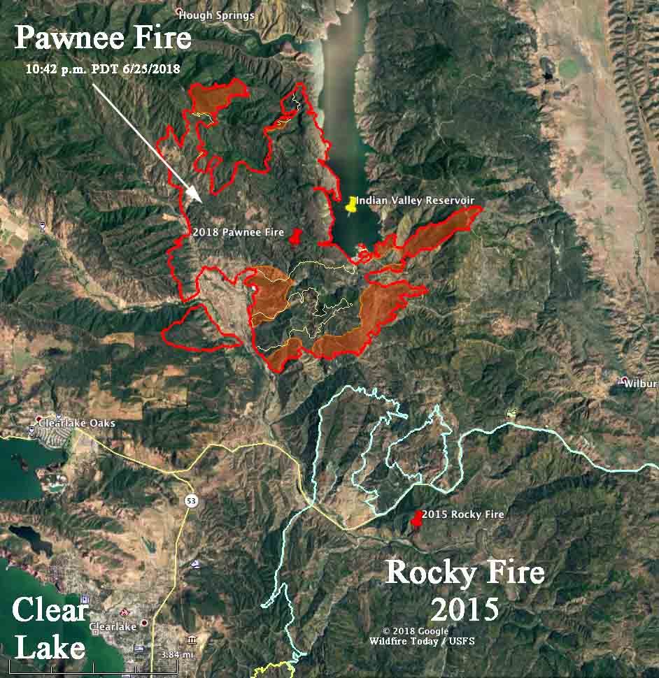
Above: 3-D Map of the Pawnee Fire looking north at 10:43 p.m. PDT June 25, 2018. The shaded areas indicate where the fire was very active.

(Originally published at 8:52 a.m. PDT June 26, 2018
(UPDATED at 1:27 p.m. PDT June 26, 2018)

The Pawnee Fire in Lake County, California continued to spread actively south and east Monday. It has not spotted across Indian Valley Reservoir, but burned around the south end of it in a long finger that ran uphill for 2.5 miles and kept going when it crossed Bartlett Springs Road at the top of a ridge. Additional spread to the east beyond that point should be slower on the downhill slope to the valley below.

The Governor’s office has declared a state of emergency for Lake County. According to CAL FIRE the Pawnee Fire has destroyed 22 structures and 600 others remained threatened. Mandatory evacuation orders are in effect for the entire Spring Valley community which is now virtually surrounded by blackened hills. The Lake County Sheriff’s Office has more information about evacuations.

Monday afternoon CAL FIRE reported that the fire had burned 10,500 acres, and Tuesday morning updated it to 11,500 — which is a very conservative number.

The weather forecast for the rest of this week for the fire area does not predict any extreme fire weather, with highs around 90, wind less than 10 mph, and relative humidity in the teens or low 20s. However, these conditions will not cause the fire to lie down. Firefighters will still have their hands full.

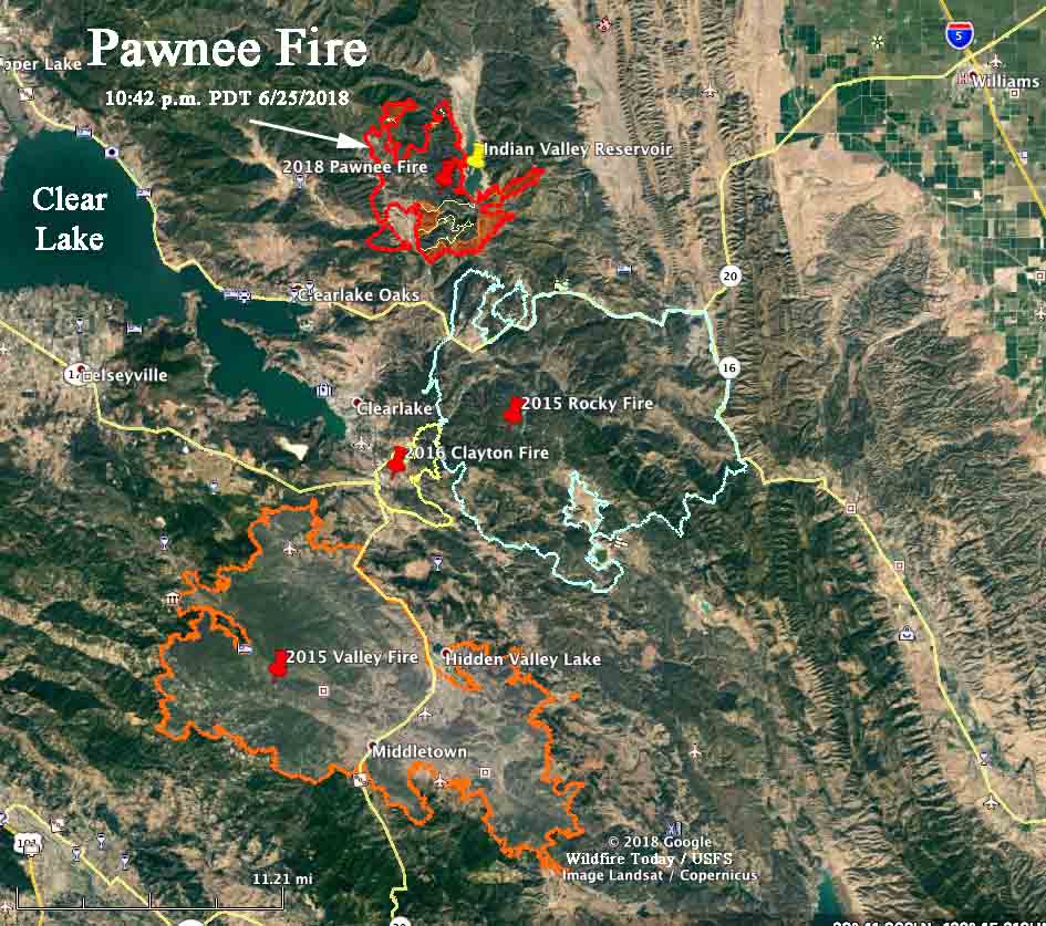
During the previous three years residents of Lake County have been seriously threatened by three other fires, the Rocky and Valley Fires of 2015 and the Clayton Fire of 2016. It is possible that the Pawnee Fire could burn into the footprint of the Rocky Fire, slowing its spread to the southeast.

rocky fire valley fire clayton fire pawnee fire
Map of the perimeter of the Pawnee Fire at 10:43 p.m. PDT June 25, 2018. Also shown are the perimeters of the Rocky (2015), Valley (2015), and Clayton (2016) Fires.

Resources assigned to the fire include:

  • 110 Engines
  • 35 Hand crews
  • 15 Helicopters
  • 58 Dozers
  • 10 Water tenders
  • 1,422 personnel, total
Map perimeterPawnee Fire
Map of the perimeter of the Pawnee Fire at 10:43 p.m. PDT June 25, 2018. The shaded areas indicate where the fire was very active.

Pawnee Fire forces evacuations in Lake County, California

Above: CAL OES Strike Team 2870C, Strike Team Leader, and #ALCOFire Battalion Chief R. Oatis at the Pawnee Fire in Lake County. Via Alameda County Fire, June 24, 2018.

(Updated at 5:56 a.m. PDT June 25, 2018)

A wildfire first reported Saturday afternoon north of the city of Clearlake in Lake County, California  grew substantially Sunday forcing hundreds of residents to evacuate.

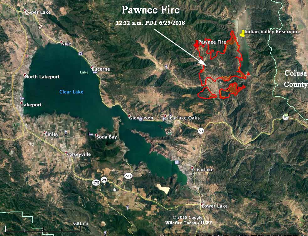
CAL FIRE reported at 6:31 p.m. PDT on Sunday that the Pawnee Fire had  destroyed 12 structures, with another 600 threatened. The Lake County Sheriff’s Office issued mandatory evacuation notices for Spring Valley and areas north of Highway 20. A mapping flight at 12:32 a.m. Monday determined that it had burned 8,502 acres.

The fire burned very actively throughout the day Sunday in the Spring Valley area northeast of Clearlake Oaks in Lake County. It was driven Sunday by low relative humidity, strong winds, and above normal temperatures. Sunday afternoon a weather station at High Glade Lookout northwest of the fire recorded 12 to 18 mph winds out of the south with gusts at 20 to 30 mph.

pawnee fire map california clear lake
Map of the perimeter of the Pawnee Fire as determined by a mapping flight at 12:32 a.m. PDT June 25, 2018.

Data from the mapping flight Sunday night showed that the fire was six miles north of the city of Clearlake and three miles northeast of Clearlake Oaks. However the fire could have grown substantially since then.

The forecast for the fire area on Monday is not expected to bring extreme fire weather. The prediction is for temperatures in the high 80s, relative humidity in the low 20s, and 3 to 6 mph winds out of the north in the morning switching to come out of the south and southwest in the afternoon. The changing wind direction could present problems for firefighters.

Several other fires are burning in Northern California, including one 21 miles southeast of the Pawnee Fire just southwest of Hershey, another fire 21 miles northeast of Red Bluff, and a third, 8 miles southwest of Redding.

We will update this article and the map as conditions change.

The Back Story: Development of the “River of Fire” book

Earlier we wrote a review of John N. Maclean’s book that he officially released today, River of Fire: The Rattlesnake Fire and the Mission Boys. It covers the 15 fatalities that occurred July 9, 1953 on the Rattlesnake Fire on the Mendocino National Forest in northern California. Of those, 14 were members of the New Tribes Mission based at a nearby forest camp at Fouts Springs. Known to the locals as missionaries, the religious group often mobilized firefighters from their ranks when fires were burning in the area. The 15th person killed was a Forest Service employee who had volunteered to carry suppers down to the missionaries, who were working on a spot fire below in a drainage where they could not be seen by the other men on the fire. And the missionaries could not see the rest of the fire.

RIVER OF FIRE by John N. Maclean

Before we had a chance to read the entire book, we asked photographer Kari Greer about her experience in creating the images. We also asked Mr. Maclean some questions about the book and how it was different from Fire and Ashes published 15 years ago.


Their emailed responses are below —
from Ms. Greer:  Maclean’s objective in having me photograph for River of Fire, in my mind was to personalize the events of the Rattlesnake Fire in 1953 for a current audience, to make it visceral and logical. Since it happened so long ago it’s easy to perceive the legend with remote nostalgia. It’s an innocuous-seeming minor drainage and that’s where the warning lies. The chaparral fuel type and the now well-worn route of the race with fire (and subsequent recovery road) are cautionary for any slope at risk for sundowner winds.

I think a visual tour helps the mind process what to look for in other similar scenarios. The lessons are there and Don Will, Daren Dalrymple, Jon Tishner, and Jim Barry have kept the hallowed site a laboratory for further introspection and reverence. It’s a heavy place loaded with ghosts who have something to teach us. Their help on-site was invaluable; I could not have seen the nuances without their expertise.


from Mr. Maclean:  River of Fire has a very different theme from my first account of the Rattlesnake Fire, published in 2003 in Fire and Ashes. That version included the first extended account of the motives of the arsonist, Stan Pattan, a re-creation of the final race with fire by more than 30 firefighters — the first semi-formal “staff ride” at the site — and a detailed check of the credibility of the fire report — and it passed. River of Fire updates all of those, but its theme looks to the future: Passing It On.

In the years since Fire and Ashes first appeared, the site of the Rattlesnake Fire has been recovered, the old firelines opened, and an explanatory memorial installed. Its lessons are passed on to new generations of firefighters and others. These days hundreds of firefighters go there every year as part of a formal staff ride. Families of the fallen have visited the site and reconnected to lost parents, friends, and their own pasts. As stories of these encounters came my way over the years I added them to the story — sometimes I wouldn’t touch the manuscript for a couple of years; other times I spent weeks in research and writing. One sad effect of the passage of time has been the loss of living memory, as participants and witnesses came to the ends of their lives, sometimes only a few days after talking to me. Earlier this year I looked at the manuscript and realized it had grown enough in bulk and scope to justify an update. Once Kelly Andersson, my longtime editor, and I started to pull it together this spring it became clear the Rattlesnake Fire had turned into a living event, its lessons now bright and alive to a new generation of firefighters. The contrast with what I had found two decades ago — a forgotten, overgrown canyon site fading into history — was extreme.

River of Fire quickly turned into a community project, a telling of the tale through the eyes of people who have lived for decades with the effects of the fire. Three past superintendents of the Mendocino Hotshots – Don Will, Daren Dalrymple, and Jon Tishner, keepers of the flame – helped enormously, and many others willingly told their stories. River of Fire contains almost everything that was in the old version: a precise account of what happened July 9, 1953, and the immediate aftermath. But as Will points out in his foreword, the Rattlesnake Fire has become a story of resurrection.

River of Fire would not have happened without the sustained enthusiasm of Andersson, who once lived in Willows herself, frequented Nancy’s Café, and knew some of these people. Andersson kept after me for years until I agreed had the material for a new book. She then brought on Kari Greer, whose photos kindle the new reality crackling to life. She also worked with the hotshot superintendents; with Chris Cuoco, the South Canyon meteorologist, who provided insight into the weather events of that day in 1953; Jim Barry, and other contributors. She edited and designed the book in both paperback and kindle, and published them both to amazon. The result is a deeper examination of a once nearly forgotten story, restored by a community to its rightful place as a landmark in the history of wildland fire.