Military mobilized to help fight wildfires

Above: Personal Protective Equipment is distributed to soldiers at Joint Base Lewis-McChord in preparation for deployment to the Umpqua North Fire in Oregon.

(Originally published at 7:53 a.m. MDT September 7r, 2017)

With the National Preparedness Level at 5, the highest level, the National Interagency Fire Center (NIFC) in Boise, Idaho has mobilized active duty military personnel to serve as firefighters to assist with wildfire suppression efforts.

The National Multi-Agency Coordinating Group (NMAC) at NIFC requested the Department of Defense to provide 200 active duty military personnel to assist with firefighting efforts. The DoD has approved the request and identified the 1-2 Stryker Brigade Combat Team (23rd Brigade Engineer Battalion and 1st Battalion 23rd Infantry Regiment), 7th Infantry Division at Joint Base Lewis-McChord (JBLM) in Washington to provide the active duty military personnel. The Soldiers will be organized into ten crews of 20 persons each, all of which will be sent to the Umpqua North Complex which is burning on approximately 30,000 acres on the Umpqua National Forest, approximately 50 miles east of Roseburg, Oregon.

“We are committed to continuing to do everything we can to provide the firefighters, aircraft, engines, and other wildfire suppression assets that Incident Commanders need to protect lives, property, and valuable natural and cultural resources,” said Dan Buckley, Chair of NMAC. “The U.S. military is a key partner in wildland firefighting and we greatly appreciate their willingness to provide us with Soldiers to serve as firefighters as well as aircraft to help with wildfire suppression efforts.”

Their training, which began September 6, is expected to conclude by September 9th, and the Soldiers are expected to begin working on a wildfire on September 10th. While on a wildfire, the Soldiers will be accompanied by experienced wildland fire strike team leaders and crew bosses from wildland fire management agencies.

The training will consist of one day of classroom training at JBLM and two days of field training when the Soldiers reach the wildfire that they will be assigned to.

The last time that active duty military personnel were mobilized to serve as wildland firefighters was in August, 2015 when 200 soldiers from the 17th Field Artillery Brigade based out of JBLM were mobilized to work on wildfires in Washington for 30 days. The last time before that was in 2006. Currently, several states – including Oregon, Montana, and Washington – have mobilized National Guard helicopters and personnel to serve as wildland firefighters to assist with wildfire suppression efforts.

army soldiers Onata Fire
File photo. Part of the Army’s assignment on the Onata Fire in 2015 was to assist putting in a hose lay as part of preparation for a planned burnout. Robert “Hippie” Horn (left) of North Dakota Forest Service hands rolls of hose to soldiers to distribute along a road. Photo by Tom Story,  August, 2015.

Eagle Creek fire burns structures and forces evacuations along the Columbia River Gorge

Above: 3-D map of the Eagle Creek Fire looking southeast, showing the perimeter at 7:30 p.m. PDT September 5, 2017.

(Originally published at 12:22 p.m. PDT, September 6, 2017)

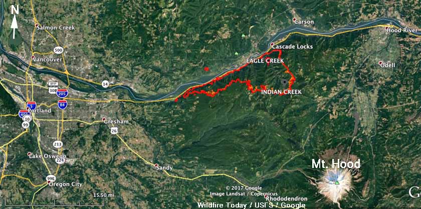
The Eagle Creek Fire that has been burning since September 2 along the Columbia River Gorge just west of Cascade Locks on the Washington/Oregon border has merged with the nearby Indian Creek Fire, which together have blackened 30,929 acres. The blaze is about 10 miles east of the Portland suburbs.

Most of the fire is on the south side of the river in Oregon, but it has jumped across the river into Washington near Archer Mountain.

Six structures have burned and there is a report that at least one of them is a residence, with the others being outbuildings.

Eagle Creek Fire
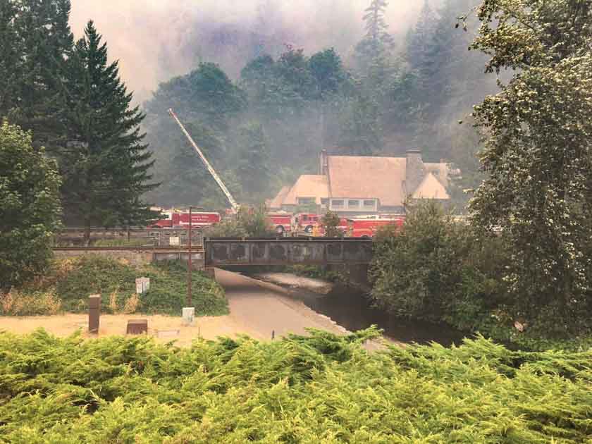
Firefighters protect the Multnomah Lodge at the Eagle Creek Fire, September 5, 2017. Inciweb.

Several communities are under evacuation orders and a shelter has been established at Mt. Hood Community College, at 3691 NE 17th Drive, Gresham, OR. For information regarding evacuations in Skamania County, contact the Skamania County Emergency Operations Center at 509-427-8076.

Firefighters will be conducting burnout operations on September 6th from Bridge of the Gods to Bonneville Dam. There will be large plumes of smoke visible during the day.

 map Eagle Creek Fire
Map of the Eagle Creek Fire showing the perimeter at 7:30 p.m. PDT September 5, 2017.

Willamette Week reported that a Portland resident saw a teenage boy using fireworks that may have started the fire. On September 5 the Oregon State Police announced that a 15-year old boy from Vancouver, Washington is a suspect.

Continue reading “Eagle Creek fire burns structures and forces evacuations along the Columbia River Gorge”

Red Flag Warnings in 5 states, September 6, 2017

This is not what the firefighters working on the 85 large uncontained wildfires in the United States need right now.

The National Weather Service has issued Red Flag Warnings or Fire Weather Watches for areas in California, Oregon, Washington, Nevada, and Idaho.

The map was current as of 11:10 a.m. MDT on Wednesday. Red Flag Warnings can change throughout the day as the National Weather Service offices around the country update and revise their forecasts.

Maps of wildfires in the Northwest U.S.

More than 27,000 firefighters are deployed on wildfires in the United States.

(Originally published at 10:35 a.m. MDT September 6, 2107)

Large wildfires Washington Oregon northern California
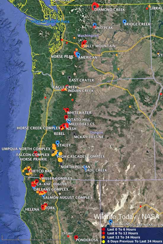
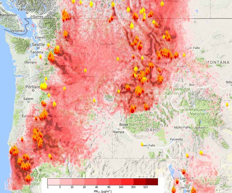
Large wildfires currently active in Washington, Oregon, and Northern California. The red, yellow, and orange dots represent heat detected by a satellite in the 24 hour period ending at 10 a.m. MDT September 6.

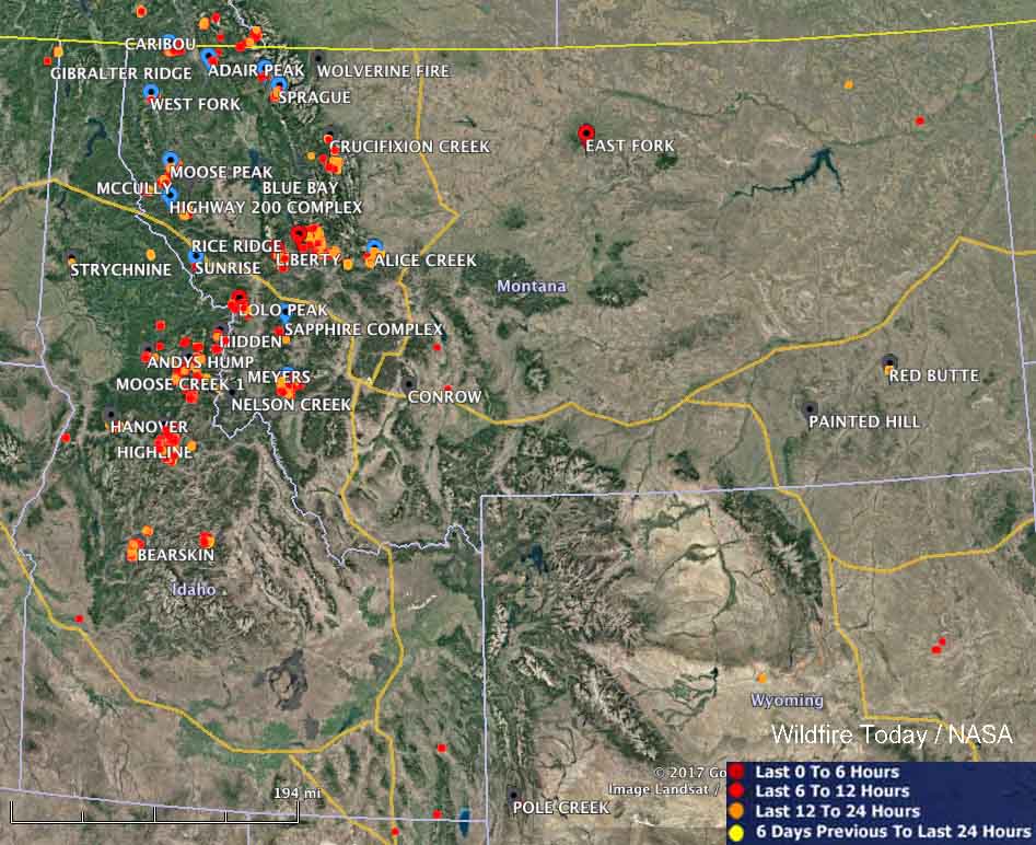
These maps show the locations of large wildfires that are currently active in the Northwest United States. The red, yellow, and orange dots represent heat detected by a satellite in the 24 hour period ending at 10 a.m. MDT September 6.

large wildfires map idaho montana
Large wildfires currently active in Idaho and Montana. The red, yellow, and orange dots represent heat detected by a satellite in the 24 hour period ending at 10 a.m. MDT September 6.

According to the National Interagency Coordination Center, today there are 50 large uncontained wildfires in the United States that are being aggressively suppressed. In addition, there are another 35 fires that are not being fully suppressed.

Very large numbers of firefighting resources are currently assigned across the United States, including 560 hand crews, 1,865 engines, and 222 helicopters, for a total of 27,256 personnel.

As of yesterday 7.9 million acres has burned this year nationally, which compares to the 10-year average of 5.4 million acres for this date.

The video below shows heat and smoke in Idaho and Montana detected by a satellite on September 3 and 4, 2017.

Wildfire smoke creates “unhealthy” air in the Northwest U.S. Wednesday

(UPDATED at 4:28 p.m. MDT September 6, 2017)

Map wildfire smoke
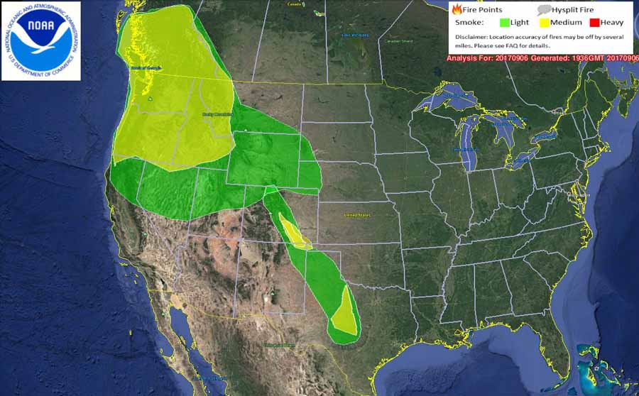
Map showing the distribution of wildfire smoke. The map was created by NOAA at 1:36 p.m. MDT September 6, 2017.

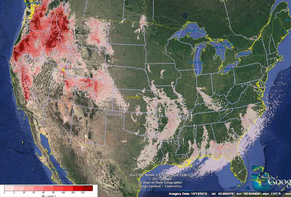
The map above showing the distribution of wildfire smoke was created at 1:36 p.m. today, Wednesday. You may notice a difference between it and the other maps below that were produced earlier Wednesday morning.

****

(Originally published at 9:40 a.m. MDT September 6, 2017. We will update this information through the day on Wednesday September 6.)

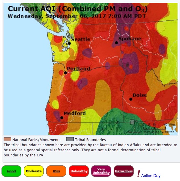
Air Quality Index for the northwestern states
Air Quality Index for the northwestern states at 8 a.m. MDT September 6, 2017. AirNow.

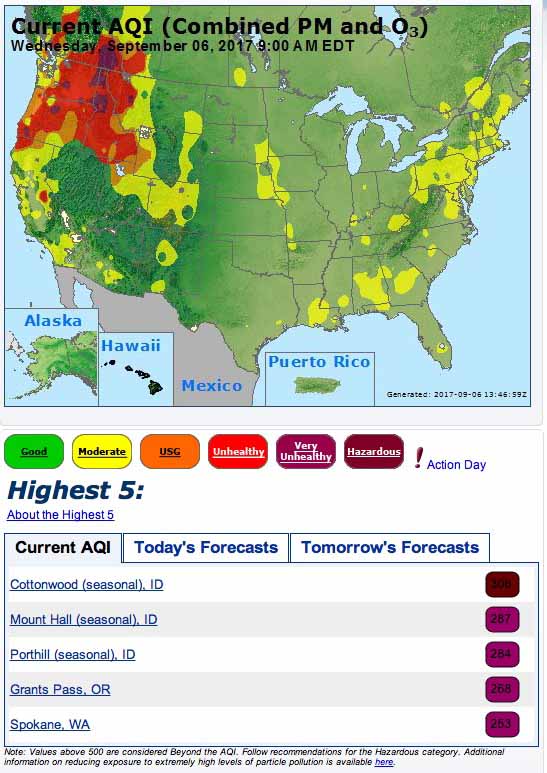
The siege of wildfires in the Northwestern United States that has persisted for several weeks continues to produce air that humans and other animals should not breathe. On Wednesday air quality classified as “unhealthy”, “very unhealthy”, or “hazardous” exists in some areas of California, Oregon, Washington, Idaho and Montana.

More detailed information about locations in the following states is available from Airnow.gov:

Air Quality Index
Air Quality Index at 7 a.m. MDT September 6, 2017. AirNow.
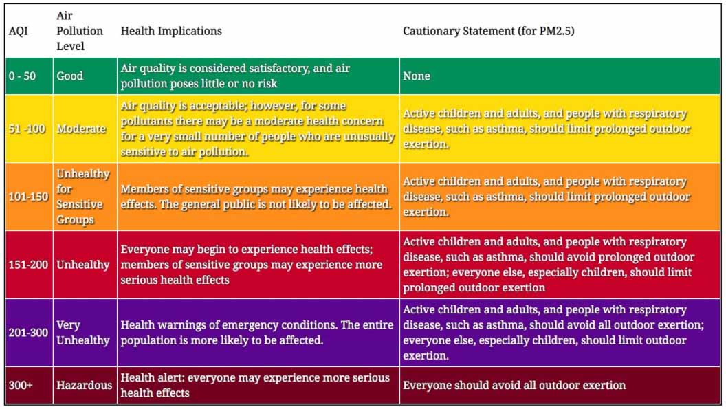
Description of Air Quality Index (AQI) categories
Description of Air Quality Index (AQI) categories. The colors may not match those used on all maps and systems, but the category names and the actual AQI numbers should hopefully be the same.
smoke forecast pm2.5
Forecast for maximum concentrations of small particles (PM 2.5) such as those found in wildfire smoke, for September 6, 2017. BlueSky.

The image below is the forecast for small particles (PM 2.5) such as those found in wildfire smoke, for September 8, 2017.

smoke forecast
Forecast for small particles (PM 2.5) such as those found in wildfire smoke, for the Northwest at 2 p.m. PDT September 8, 2017. BlueSky.

Uintah Fire burns homes south of Ogden, Utah

Approximately six homes have burned and a Type 1 Incident Management Team has been ordered.

(UPDATED at 8:41 p.m. MDT September 5, 2017)

The Type 1 Incident Management Team (IMT) previously ordered for the Uintah Fire southeast of Ogden, Utah near the community of Uintah has been changed to a Type 3 IMT.

The perimeter was mapped Tuesday evening with GPS; the result, 619 acres.

At 7 p.m. Tuesday 250 homes are still under evacuation orders, according to ABC 4 News.

Local residents can call 211 for information about the fire. I-84 eastbound and westbound is now open.

(Originally published at 3:13 p.m. MDT September 5, 2017)

Uintah Fire
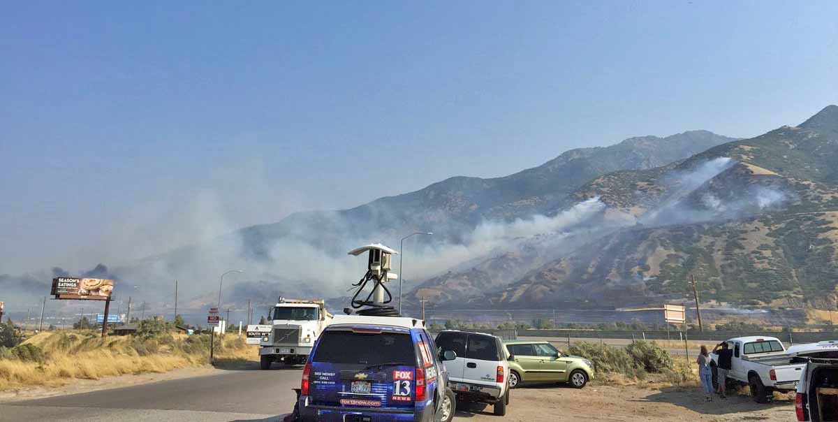
The Uintah Fire at about 10 a.m. September 5, 2017. Photo by Weber Fire District.

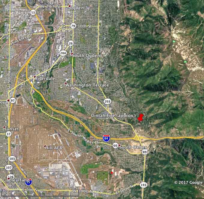
The Uintah Fire that started around mid-morning Tuesday has burned approximately six homes and caused evacuations southeast of Ogden, Utah near the community of Uintah. Both Highway 89 and Interstate 84 were closed at one point as the fire burned near 89 and jumped across and then burned along the interstate to South Weber where structures were involved.

Uintah Elementary School was evacuated as well as an assisted living facility and several neighborhoods.

At about noon aircraft began working the fire, and National Guard helicopters were mobilized. At one point a small drone was spotted a few hundred yards from helicopters that were assisting firefighters.

map of Uintah Fire
The red pin shows the approximate location of the Uintah Fire.

At noon the size was estimated at 500 acres and it was running to the northwest. A Type 1 Incident Management Team has been ordered. At 1:22 p.m. MDT the Weber Fire District reported that five fixed wing aircraft and two helicopters were working the fire along with numerous fire engines and ground-based firefighters.

The fire was driven by very strong down-canyon winds blowing to the west where I-84 climbs up the drainage to the east. The Power Plant weather station at the Interstate recorded 12 to 24 mph sustained east winds gusting at 28 to 45 mph. The temperature was in the 70’s with a relative humidity of 30 percent.

Continue reading “Uintah Fire burns homes south of Ogden, Utah”