Bovee Fire prompts evacuation of Halsey, Nebraska

Multiple structures reportedly destroyed at 4-H camp

Updated 5:26 p.m. CDT Oct. 4, 2022

Bovee Fire map, Oct. 4, 2022
Bovee Fire map, Oct. 4, 2022. Data acquired by the Colorado State Multi-mission aircraft late Tuesday morning. This was originally unofficial, but has now been accepted by the Incident Management Team.

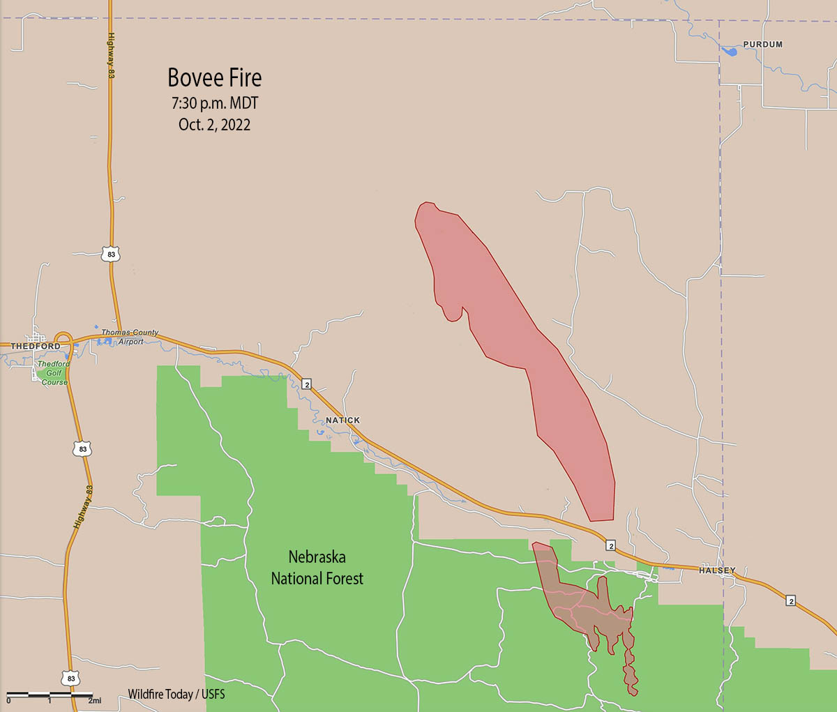
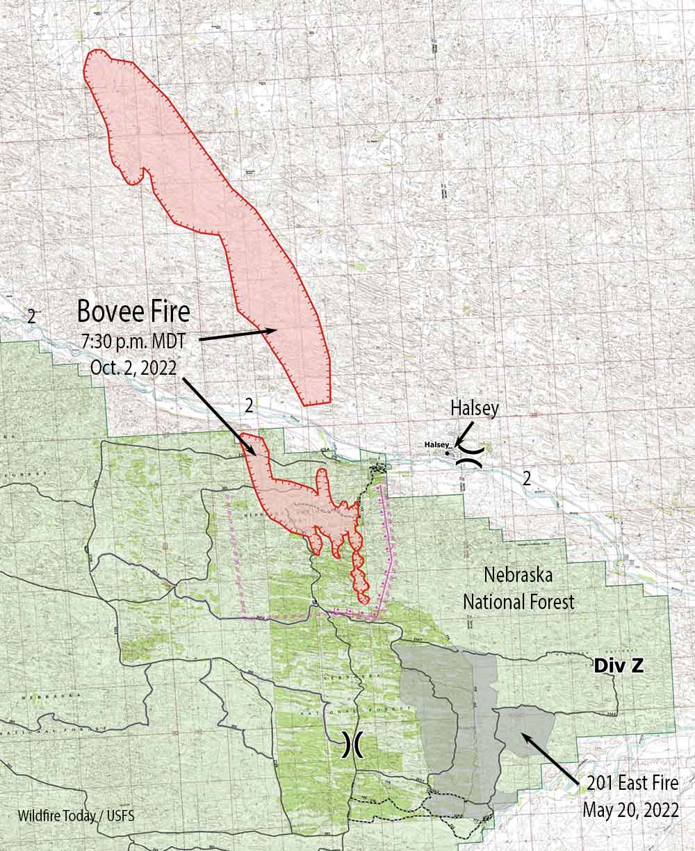
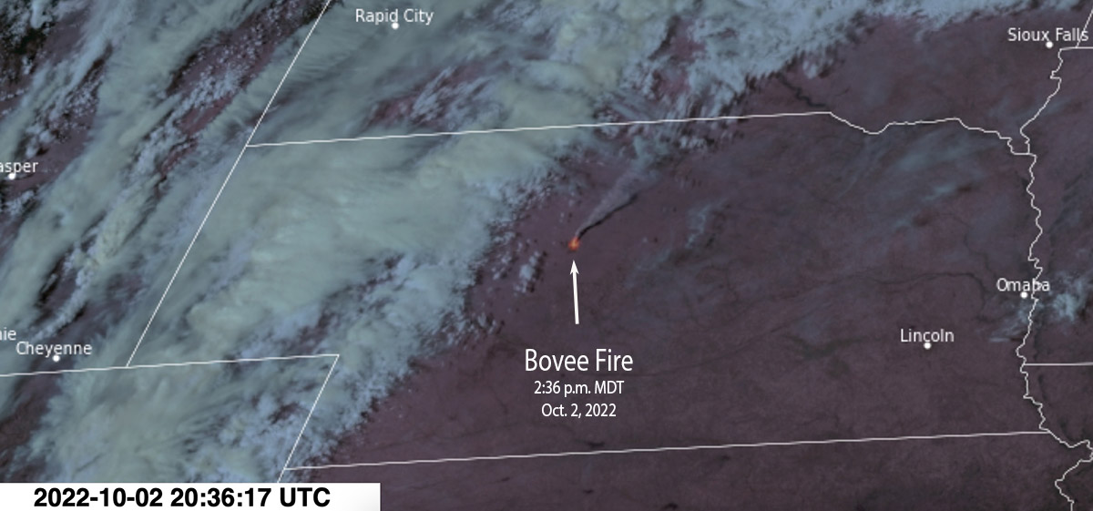
An updated map is available for the Bovee Fire near Halsey, Nebraska, showing that it has burned approximately 18,932 acres. Compared to the last map update Sunday night it is shown to be substantially farther to the north, crossing from Thomas County into Cherry County. The overall length, north to south, is 17 miles and at its widest point southwest of Halsey is 3 miles across.

All evacuations on the fire have been lifted and Highway 2 is open. Drive with caution, firefighters advise, as there may be heavy fire traffic and smoke in the area.

In the video below recorded Tuesday morning Planning Section Chief Tom Barter presented an update. At that time he did not have access to the newest map, above.


Updated 7:39 p.m. CDT Oct. 3, 2022

Showers and high humidity have slowed the spread of the Bovee Fire west of Halsey, Nebraska. Two weather stations west and north of the fire have recorded 0.24″ and 0.17″ of rain since 1 a.m. Monday.

The Rocky Mountain Complex Incident Management Team, led by Incident Commander Dan Dallas, is en route to the incident.

Bovee Fire map 7:30 p.m. Oct 2, 2022.

The Lincoln Journal Star reported that a volunteer firefighter, Mike Moody assistant Chief of the Purdum Volunteer Fire Department, died at the fire Sunday after suffering a medical emergency. Moody, 59, had served with the department for more than 40 years and had previously been its chief, according to a news release from the agency.

“We had a good night last night and made a lot of progress on the east and north,” said Incident Commander Brian Daunt. “Today’s focus is going to be holding those lines, and constructing line to the west of the fire.”

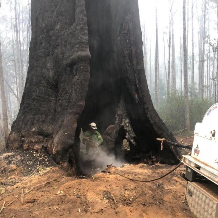
More than 100 firefighters are on scene, including two Interagency Hotshot Crews, 10 engines, and a dozer. Colorado’s Multimission Aircraft is scheduled to fly the fire this afternoon to provide detailed infrared mapping of the fire perimeter.

A mapping flight at 7:30 p.m. Sunday found that the fire had burned 7,780 acres. Officially, the Nebraska National Forest is still going with 15,000 acres, an estimate developed Sunday afternoon before it was mapped from an aircraft.

Nebraska Highway 2 has been reopened between Thedford and Halsey.


11:53 a.m. CDT Oct. 3, 2022

Bovee Fire map 7:30 p.m. Oct 2, 2022.

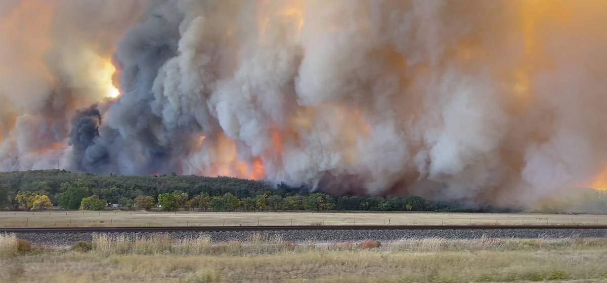
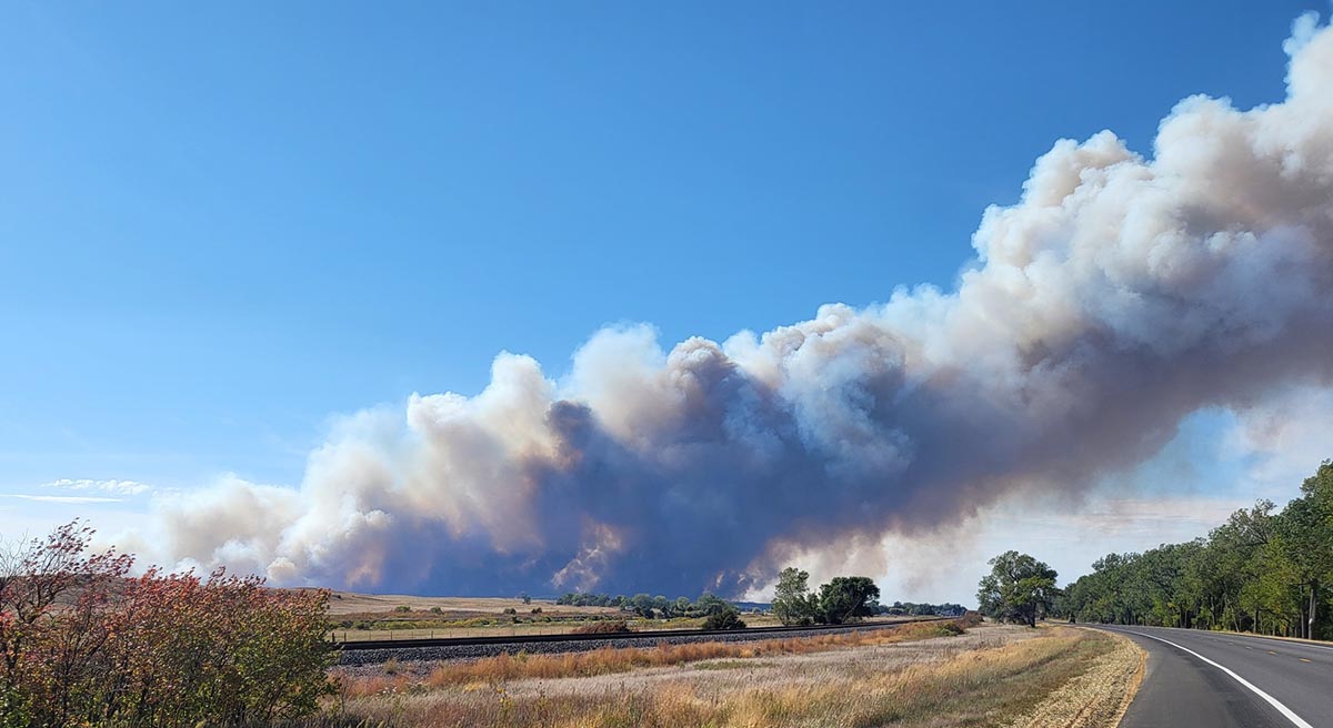
The Bovee Fire has prompted an evacuation of the community of Halsey in central Nebraska. After it was reported Sunday at 1:38 p.m. CDT it spread north very rapidly. When the fire was mapped at 7:30 p.m. it had blackened 7,780 acres.

It is burning on the Nebraska National Forest and on private land on both sides of Highway 2 west of Halsey, 13 miles southeast of Thedford.

Bovee Fire, Oct. 2, 2022
Bovee Fire, Oct. 2, 2022. By Voice News West.

The Forest Service reported that multiple large and single engine air tankers assisted firefighters Sunday and an incident management team has been ordered.

Multiple structures are reported to have been destroyed at the Nebraska State 4-H camp.

Nebraska State 4-H Camp structures burned fire

When the fire started the relative humidity was in the 20s and the wind was gusting to 34 mph out of the south-southeast. The wind speed decreased overnight as clouds moved in and after midnight light rain was detected at the Thedford Airport. A weather station north of the fire at the Valentine National Refuge measured 0.13″ Monday between 2 and 11 a.m. CDT.

Bovee Fire satellite photo, 236 p.m. MDT Oct. 2, 2022
Bovee Fire, Oct. 2, 2022. USFS photo
Bovee Fire, Oct. 2, 2022. USFS photo.

In May of this year the 201 East Fire just south of the current Bovee Fire burned 4,100 acres in the Nebraska National Forest.

Wildfire potential shifts to the south-central states

wildfire potential map

The forecast for wildland fire potential issued October 1 by the National Interagency Fire Center predicts that the wildfire potential shifts to the south-central United States over the next several months. Most of California has received more than the average amount of rain recently.

However some of the Southern California mountain areas have not received much wetting rain, therefore the prediction there is for above normal fire potential in October and November, possibly into December. The first widespread wetting rain this fall will likely follow two to three offshore wind events in Southern California.

NIFC’s monthly forecasts are for the next four months, but in the shorter term, by the end of this week temperatures in the western US and Canada are expected to be 5C to 10C degrees above average for the date.

Temperatures week of Oct 2, 2022
Temperature anomaly October 9, 2022.

The fire potential text and maps from NIFC shown here represent the cumulative forecasts of the ten Geographic Area Predictive Services Units and the National Predictive Services Unit. Additional graphics are included from other sources.

Below:

  • Excerpts from the NIFC narrative report for the next four months;
  • Additional NIFC monthly graphical outlooks;
  • NOAA’s temperature and precipitation forecasts;
  • Drought Monitor;
  • Keetch-Byram Drought Index;
  • Soil moisture.

“Drought continues in much of the West, with expanding and intensifying drought in portions of the Northwest, Idaho, and Montana due to warmer and drier than normal conditions in September. Most of California received well above normal rainfall for the month and much of the Northeast did as well, helping to reduce drought in New England. Warmer and drier than normal conditions also occurred in much of the southern and northern Plains into parts of the Southeast, Texas, and Midwest.

“Near normal temperatures and near to above normal precipitation are likely for portions of the Pacific Northwest and northern Rockies into early winter. Near to below normal precipitation is forecast for the rest of the West through the southern and central Plains into the Gulf Coast and Southeast, barring any landfalling tropical cyclones on the Gulf and Atlantic Coasts. Near to above normal temperatures and near normal precipitation are forecast for the Midwest through the Mid-Atlantic and Northeast.

“Above normal significant potential is forecast for much of Oklahoma, Texas, the Lower Mississippi Valley, and central Gulf Coast into December. Above normal potential is likely for much of the Mississippi Valley in October and the western Ohio Valley through the Ozarks into November. Southern Area is forecast to return to near normal significant fire potential during January.

“The Transverse and Peninsular Ranges of southern California to the coast, areas prone to Santa Ana winds, will have above normal significant potential October through November, before returning to normal potential in December. The Hawai’ian Islands will continue to have above normal potential, especially lee sides, through November before returning to normal potential in December. All the US is forecast to have near normal significant fire potential during January.”


wildfire potential map wildfire potential map wildfire potential map

NOAA temperature and precipitation outlooks Drought Monitor, Sept. 27, 2022 KBDI October 1, 2022

Soil Moisture, October 1, 2022

Use of three large helicopters dropping retardant at night may have limited size of Route Fire

In September it burned 5,280 acres north of Los Angeles between Interstate 5 and Castaic Lake

Route Fire map, Sept. 3, 2022
Route Fire map, Sept. 3, 2022.

This article was first published at Fire Aviation.

A report produced by the managers of Southern California’s Quick Reaction Force (QRF) of four helicopters concludes that the aggressive aerial attack working with the units on the ground likely limited the final size and cost of the Route Fire. The fire started at about noon on August 31, 2022 and ultimately burned 5,280 acres north of Los Angeles between Interstate 5 and Castaic Lake. (Download the 3.2 Mb report)

This is a different incident from the Route Fire that burned 454 acres a few miles away along Interstate 5 September 11, 2021. You may remember that fire as the one where 13 firefighters who were becoming rapidly entrapped were crammed into two US Forest Service engines and rescued with only moments to spare. There were 23 bodies in the two engines, with seating designed for five each. Another 11 firefighters not quite as close to the flames were rescued by Los Angeles County engines.

The four QRF helicopters are all staffed for 24-hour coverage and equipped for night flying. With most of their base funding supplied by Southern California Edison they are located in Orange, Los Angeles, and Ventura Counties. Two of the helicopters are CH-47 Chinooks, one is an S-61, and the fourth is an S-76 used for aerial supervision. The helicopters are dispatched as a unit along with a mobile fire retardant base and can drop water until the base is established. The fact that they can drop retardant 24 hours a day, when fixed wing aircraft can’t work the fire at night, can be a game changer. During the Route Fire the mobile retardant base did not have to travel, it was set up at its base about 10 miles from the fire.

Quick Reaction Force helicopters
Quick Reaction Force helicopters. From the QRF report.

The assignment given to the QRF by Los Angeles County Fire Department on the Route fire was for it to stop the spread to the north. The S-61 was tasked to hold a particular location on the fire, using water from the adjacent Castaic Lake. It averaged of 696 gallons per drop.

The two Chinooks dropped averages of 2,434 gallons of water per drop and 1,896 gallons of retardant per drop. The three suppression helicopters flew an average of 9 hours each that afternoon and into the night, dropping 223,000 gallons of water and 55,000 gallons of retardant. The S-76 was used for 17 hours. The total cost of the retardant and flight time for the four ships was $403,950.

Map of 2022 Route and 1996 Marple Fires
Map of 2022 Route and 1996 Marple Fires. From the QRF report.

The report compares the Route Fire to the 1996 Marple Fire which started in about the same location at the same time of the day and time of year in similar weather conditions. By midnight the Marple Fire had exceeded 10,000 acres and continued spreading for two or three days until it was stopped at 19,860 acres.

Retardant line on north side of Route Fire, Sept. 1, 2022
Retardant line on north side of Route Fire, Sept. 1, 2022. From the QRF report.

In contrast, the spread of the Route Fire was stopped at 8 a.m. on Day 2. The three helicopters dropped water and retardant much of the night to hold it at a ridge on the north side, allowing hand crews and dozers to complete fire line.

It is very difficult to compare the suppression costs of two fires that occurred 26 years apart, but the authors of the QRF report estimated that the cost of the Marple Fire in today’s dollars would be somewhere between $70 million and $140 million. The cost of the Route Fire was $7 million to $8 million.

QRF delivery statistics, Route Fire

Presumptive disease program for wildland firefighters effective this month in Victoria, Australia

firefighters save Messmate tree Victoria Australia
Firefighters work to save a Messmate in Victoria, Australia. Photo by Forest Fire Management Victoria.

The presumptive disease program passed last year by Victoria’s Parliament went into effect September 14, 2022.

It extends the program to wildland firefighters and includes “surge firefighters” who are government employees normally in other roles, but who perform firefighting duties during the fire season as part of their agency’s surge capacity as needed.

The presumptive disease program ensures that if a firefighter is diagnosed with any of the 12 listed cancers, they will not have to prove that it was caused by their employment, and it will be considered an on the job injury.

The cancers covered are brain, bladder, kidney, non-Hodgkins lymphoma, leukemia, breast, testicular, multiple myeloma, prostate, ureter, colorectal, and esophageal.

The compensation applies to forest firefighters who:

  • have been diagnosed since 1 June 2016 with one of the 12 specified types of cancer;
  • have served in active firefighting roles for a specified number of years, depending on the cancer type;
  • are diagnosed during their service or within 10 years after they’ve finished their service.

A partial year of service is counted as a full year of service to recognize seasonal workers. Previous service as a volunteer or career firefighter and equivalent interstate service count toward the qualifying period.

More information.

Several issues important to wildland firefighters discussed during Senate Hearing Thursday

Senate Energy and Natural Resources Committee
Senate Energy and Natural Resources Committee. Sept. 29, 2022.

During a hearing today before the Senate Energy and Natural Resources Committee a number of issues important to federal wildland firefighters were discussed. The two witnesses from the agencies were John Crockett, Associate Deputy Chief, State and Private Forestry, Forest Service, and Jeff Rupert, Director of the Office of Wildland Fire for the Department of the Interior.

We don’t have time to get into the details, but here are the points at which some key topics were covered in the video above, which shows the entire hearing:

  • 45:19. Three-day break in service which can result in a firefighter (FF) losing eligibility for FF retirement.
  • 49:50. Forest Service counting the same acres of fuel treatments multiple times.
  • 54:47. FF mental health.
  • 1:00:00. Protecting Giant Sequoias from fire during their 3,000-year life span.
  • 1:06:30. How many firefighting aircraft do the agencies have?
  • 1:22:20. FF pay, and a long term solution.
  • 1:27:50 and again at 1:37:30. A possible new requirement for air tankers to have pressurized cabins.
  • 1:33:45. Why have the agencies not accomplished more acres of fuel treatments?

The Grassroots Wildland Firefighters clipped portions of the hearing, as you’ll see in the short videos below.

Senator Murkowski asks the USFS and DOI about long-term pay for Federal Wildland Firefighters:

Senator Heinrich asks the DOI what they are doing for Firefighter Mental Health:

Forest Service and DOI Respond to Three-Day Break In Service Issue for Wildland Firefighters:

Senate unanimously passes bill to improve FEMA’s response to wildfires

The Camp Fire, November 8, 2018
The Camp Fire, November 8, 2018. NASA (Joshua Stevens) – NASA Landsat 8.

When most people think of the Federal Emergency Management Agency (FEMA) what comes to mind is the assistance the agency provides before and after hurricanes, tornadoes, and floods. Part of their mission and the ways in which the assistance is supplied has been specified by the 1988 Stafford Act and before that, the Disaster Relief Act of 1974.

FEMA’s current procedures and requirements don’t always work for post-wildfire recovery needs, and a bill passed unanimously by the Senate Wednesday will help close some of those gaps. The FEMA Improvement, Reform, and Efficiency (FIRE) Act, S.3092, would help ensure that FEMA’s disaster preparedness and response efforts fully address the unique nature of wildfires and their impacts on communities.

If the bill is passed by the House of Representatives and signed by the President, FEMA would be able to pre-deploy resources during red flag warnings – periods of high fire danger, when catastrophic wildfires are most likely to start – just like they already do in advance of hurricane warnings.

The bill would also help ensure relocation assistance is accessible for public infrastructure in fire prone areas. It would improve FEMA’s response to wildfire-specific damage, such as repairing and mitigating contamination from damaged infrastructure.

If passed, it would have FEMA provide culturally-competent crisis counselors and case managers to ensure that underserved and disadvantaged communities receive equitable treatment when accessing federal disaster assistance. Tribal governments would be able to access financial assistance to upgrade their emergency operation centers, putting them on an equal standing with state and local governments.