California OES and military partner to create an engine strike team

Cal OES and California Military Department Type 6 engines
Cal OES and California Military Department’s Type 6 engines. CAL OES photo.

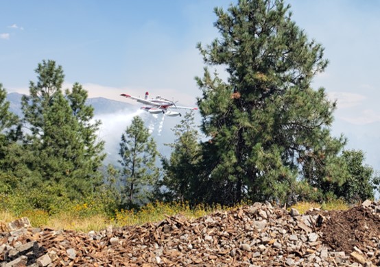
This week the California Governor’s Office of Emergency Services (Cal OES) and the California Military Department announced the creation of the first all-hazards fire engine strike team operated by a state military department.

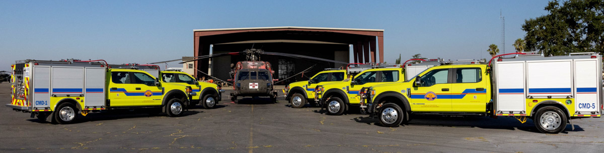
Cal OES is deploying a Type 6 strike team of wildland-style fire engines, named Team Blaze, to the State Military Department to enhance California’s Fire and Rescue Mutual Aid fleet.

These four-person engines complement the Military Department’s existing Task Force Rattlesnake hand crew program consisting of Soldiers and Airmen. Since the start of operations in 2019, Task Force Rattlesnake has cut, cleared and treated at-risk wildfire project areas in central and northern of California.

The State’s Military Department maintains a firefighting program at their military bases, with trained personnel providing firefighting prevention, mitigation and protection services to California and military bases and camps.

“We are proud to collaborate with Cal OES to ensure there’s another fleet of fire engines and expert staff at the ready,” said California Military Department Major General Matthew P. Beevers. “This Strike Team builds upon the state’s response efforts during times of need.”

Cal OES and California Military Department Type 6 engines
Cal OES and California Military Department Type 6 engine. CAL OES photo.

These engines add to the existing California Fire and Rescue Mutual Aid System fleet of more than 270 engines across 60 local partners statewide that can respond to incidents of all types.

Cal OES facilitates the California Fire and Rescue Mutual Aid System, which moves local government resources across the state in support of all-risk emergency response on behalf of local, state, and federal government fire organizations. Cal OES assigns local government fire agencies with fire apparatus to maintain surge capacity during day-to-day duties and major events/emergencies.

Firefighters battle the East Fire northeast of Glendora, California

East of San Gabriel Reservoir

Updated 5:36 a.m. PDT August 26, 2022

Map of the East Fire 7:18 p.m. August 25, 2022

The East Fire in the Angeles National Forest northeast of Glendora has been relatively quiet since the spread was stopped Thursday evening. It was last mapped at approximately 147 acres.


Updated at 6:18 p.m. PDT August 25, 2022

East Fire, looking northwest from Sunset Peak
East Fire, looking northwest from Sunset Peak at 5:45 p.m. Aug 25, 2022.

The spread of the East Fire northeast of Glendora, California has slowed and is mostly holding at the ridges, thanks to the efforts of the firefighters on the ground and in the air. At about 5 p.m. Air Attack estimated the size at approximately 135 acres with about two-thirds of the fire above Shoemaker Canyon Road and one-third below the road. However that size estimate could change.

East Fire -- August 25, 2022
East Fire at approximately 3:50 p.m. August 25, 2022.

At 5:45, in addition to helicopters, a lead plane, and air attack, there were two large air tankers over the fire, an MD-87 and an S-2T.


3:53 p.m. PDT August 25, 2022

map East Fire Glendora
The red squares on the map represent heat detected by a satellite at 1:50 p.m. PDT Aug. 25, 2022 on the East Fire northeast of Glendora, CA.

Thursday afternoon the East Fire started eight miles northeast of Glendora, California east of San Gabriel Reservoir near East Fork Road and Shoemaker Canyon Road.

It received a typical Southern California aggressive initial attack with hand crews, engines, helicopters, water tenders, and air tankers, including a DC-10 that was based nearby at San Bernardino.

East Fire at 3:17 p.m. Aug. 25, 2022
East Fire at 3:17 p.m. Aug. 25, 2022. ABC7.

At 3:29 p.m. the FIRIS aircraft mapped it at 73 acres.

The video below shows a US Forest Service engine and a hand crew having to be relocated as flames approached the turnout where it was parked.

East Fire
East Fire, looking northwest from Sunset Peak at 3:14 p.m. Aug. 25, 2022.

We will update this article as more information becomes available.

Helicopter pilot describes dropping water on a large fire whirl

Or was it a fire tornado?

Fire whirl on the Sam Fire in LA County, Aug. 10, 2022
Fire whirl on the Sam Fire in LA County, Aug. 10, 2022. KTLA-2

On August 11 we wrote about an impressive fire whirl (or fire tornado) that occurred on the Sam Fire in northwestern Los Angeles County August 10. Thankfully a helicopter from KTLA 5 was airborne and got compelling video, including a water drop from an Air-Crane helicopter that at least for a few seconds took most of the energy out of the rapidly rotating vortex of flame.

Here is the video:

Unfortunately the video stops immediately after the water drop so it is unknown if it regenerated.

In describing the event, we wrote, “Maybe a helicopter pilot can tell us how ballsy it was, or was not, to fly close enough to drop water on the fire whirl.”

Now we know who made the drop.

Erickson’s Pilot in Command flying the Air-Crane that is seen dropping water, Ed Montgomery, was quoted in Erickson Incorporated’s Twitter feed, @EricksonInc. Below is the text from a series of six tweets:

What I can tell you is that those types of situations are very intense, for not only the aircraft on the fire but also for the firefighters that are on the ground. Fire tornadoes can and often do throw fire balls out in front of the fire and the threat in this particular instance, was that the highway was the fire line, and the tornado was approaching the highway. If it had been allowed to advance it would have certainly spotted fire across the highway and turned a 140 acre fire into a much larger incident.

We were fortunate to have had N163AC as our aircraft – it has our new composite blades installed and we were at the last quarter of our fuel cycle. This means we were able to pick up 2,300 gallons of water for that drop.

As you can see from the video, fire tornadoes create a tremendous amount of inward air flow to its core. All I really needed to do was get in front of it while it was in the open, be away from the heat column, and high enough for the tornado to suck the entire water drop into its core.

The phenomenon was either a fire whirl or fire tornado. It is difficult to tell from the video the width or height of the vortex. It appears not to be huge, but the speed of the rotation was extremely swift and the area influenced by the strong indrafts was very large. At the one minute mark check out the spot fires that ignite and instantly grow much larger as they are drawn toward the vortex.

Fire whirls, much like dust devils, are not uncommon on a fire when the atmosphere is unstable, and are much smaller than fire tornados. In 1978 a researcher for the National Weather Service in Missoula, David W. Goens, established parameters for the two.

He said the average size of a fire whirl is usually 33 to 100 feet, with rotational velocities of 22 to 67 MPH.

But a fire tornado dominates the large scale fire dynamics. They lead to extreme hazard and control problems. In size, they average 100 to 1,000 feet in diameter and have rotational velocities up to 90 MPH.

Nearly 40,000 lightning strikes in CO, WY, SD, and NE

Lightning strikes during 24-hour period
Lightning strikes during 24-hour period ending at 6 a.m. Aug. 24, 2022. Lightning strike data from Rocky Mountain Area Coordination Center.

During the 24-hour period ending at 6 a.m. Wednesday 39,421 lightning strikes were detected in parts of Wyoming, Colorado, South Dakota, and Nebraska. In many areas there was not a great deal of rain accompanying the lightning.

Precipitation during 24-hour period
Precipitation during 24-hour period ending at noon Aug. 24, 2022.

The weather forecast for Cheyenne, Wyoming on Wednesday is for 84 degrees, 12 mph winds out of the southeast, 30 percent cloud cover, and 22 percent relative humidity.

The satellite photo taken at 11:56 a.m. MDT on Wednesday shows partly cloudy skies over the general region.

Satellite photo, 11:56 a.m. MDT Aug. 24, 2022
Satellite photo, 11:56 a.m. MDT Aug. 24, 2022.

Beer company giving away flameless solar cookers to help prevent forest fires

Solar cooker campaign by Busch Light

Anheuser-Busch has come up with a unique way to promote one of their brands while also, perhaps, reducing the chances of an illegal campfire starting what could become a devastating wildfire.

The company is giving away in certain areas of Colorado solar powered flameless cookers which supposedly can be used by campers to prepare a warm meal in a remote area.

“On average, 85% of forest fires are caused by humans and many of those man-made disasters are attributed to poorly attended campfires,” they wrote on their website. “That’s why Busch Light is distributing Busch Light Solar Cookers at the peak of Colorado camping season, offering a flame-free way to enjoy a warm meal and ice-cold beers with fire safety in mind.”

Website visitors can sign up for a chance to get a free cooker at local Colorado fire departments in Red Feather Lakes (August 19th), Nederland (August 26th), or Estes Park (September 2nd) through Labor Day weekend.

The cooker appears to be very similar to an item sold on Amazon for $41.


Civilian use of drone delays firefighting efforts in North Idaho

single engine air tanker drops on the Moyie Fire
A single engine air tanker drops on the Moyie Fire August 21, 2022 near Moyie Springs, Idaho. Photo by Idaho Department of Lands.

Firefighters on the ground battling the Moyie Fire had to wait on aircraft support because a civilian drone was being flown in the area August 21 near Moyie Springs.

Aircraft ordered for the fire could not immediately fly because of the drone.

“The residents of approximately 50 homes in Moyie Springs were notified of the fire and the potential need for evacuation,” said Josh Harvey, Idaho Department of Lands  Fire Bureau Chief. “Clearly, we needed to get air support for the firefighting effort as soon as possible and the drone put that on hold. Unfortunately this type of situation is not uncommon. We are reminding the public that drones can put firefighters, homes, and resources at risk.”

After the drone was gone, multiple firefighting aircraft went to work attacking the fire repeatedly while ground crews constructed a fire control line using hand tools. The fire was kept to three acres.

It is very dangerous to fly a civilian drone near a fire at which helicopters or fixed wing aircraft are operating. A collision could impact the windscreen or damage the engine, props, rotors, or flight control surfaces, causing a crash. If a drone is seen near a fire the standard operating procedure is to remove all aircraft from the fire area until it is confirmed that the drone has left the scene. In other words, it interferes with firefighting efforts.

It’s a federal crime punishable by up to 12 months in prison to interfere with firefighting efforts on public lands. Additionally, Congress has authorized the FAA to impose a civil penalty of up to $20,000 against any drone pilot who interferes with wildfire suppression, law enforcement, or emergency response operations. The FAA treats these violations seriously, and will immediately consider swift enforcement action for these offenses.