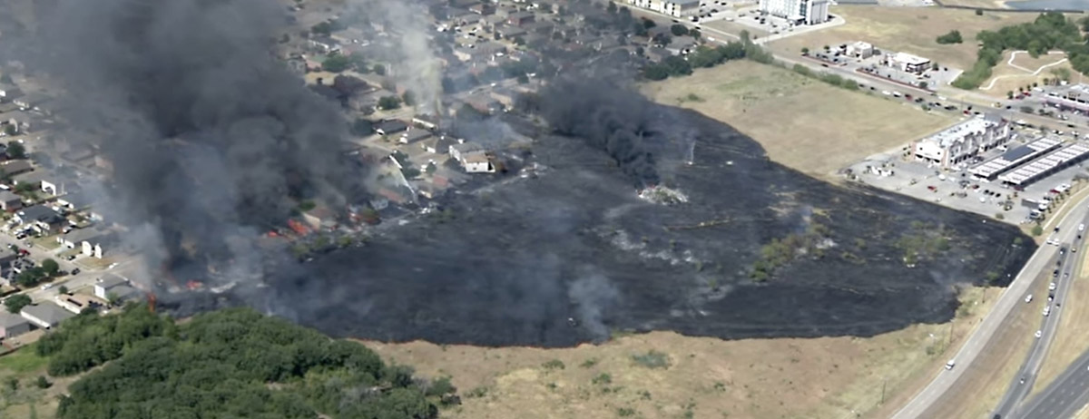
Grass fire spreads into neighborhood in Balch Springs, Texas, July 25, 2022. Image from video by FOX 4 Dallas-Fort Worth.
A grass fire burned into a suburb of Dallas, Texas Monday afternoon destroying 9 homes and damaging another 17, according to city officials. It occurred in Balch Springs when a mower struck an object in a field, creating a spark which ignited dry grass near Interstate 20 and South Beltline Road.
A steady breeze pushed the fire into a row of houses adjacent to the field. One by one the fire ignited house after house, aided by a fence that ran behind and between all of the homes which contributed to the fuel load and the continuous spread.
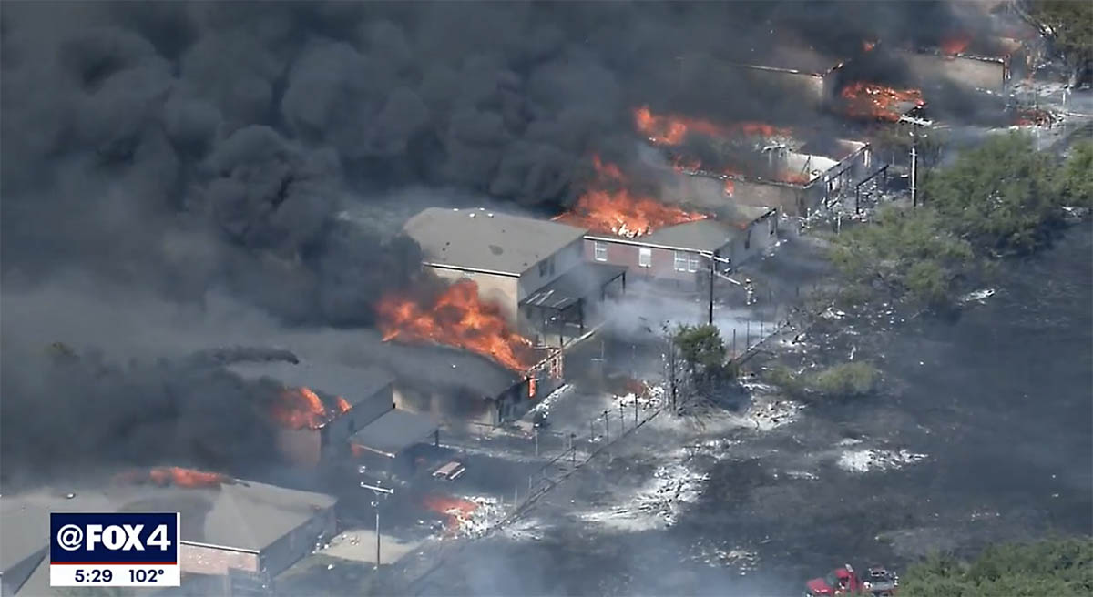
Grass fire spreads into neighborhood in Balch Springs, Texas, July 25, 2022. Image from video by FOX 4 Dallas-Fort Worth.
In the 30-minute video below very few firefighters are seen for the first 20 minutes. Balch Springs, with an estimated population of about 25,000 in 2019 has about eight firefighters working on any given day, Fox 4 news reported. The fire was well established when the video began, with at least one home already burning.
Looking at the video from a firefighter’s perspective, it is interesting to see how the fire progresses as the fence and outbuildings burn intensely, structures ignite, police gather in the street, a dog in a backyard looks worried (at 17:48), and little is seen in the video to initially stop the spread through the field or the neighborhood. However we don’t see the street side of the homes except at the very beginning; there may have been more firefighter activity on that side. There was a tower/ladder truck in the street that looked like it kept about four houses from being destroyed.
Our hearts go out to the residents who lost their homes.
N388RA Boeing CH-47D preparing to take off at Penticton Airport in British Columbia July 16, 2022. Image from VMC Aviation Videos.
The US Forest Service has released a brief initial report about the July 21 crash of the Boeing CH-47D helicopter in the Salmon River while working on the Moose Fire 20 air miles northwest of Salmon, Idaho. The two pilots were killed.
Below is the complete text of the narrative section of the document which was dated July 22, 2022, but was not posted on the Wildland Fire Lessons Learned site until today around noon.
On Thursday, July 20, a call when needed CH-47D Series Chinook Helicopter crashed into the Salmon River, adjacent to the Indianola Work Center approximately 11 miles west of North Fork, Idaho on the Moose Fire. The aircraft sustained severe damage, the pilots were extracted and transported to hospitals but both sustained fatal injuries. The NTSB has been notified and will be conducting an accident investigation. The USDA Forest Service has assigned a learning review team.
The pilots, the only personnel on board, were Thomas Hayes, 41, of Post Falls, Idaho, and Jared Bird, 36, of Anchorage, Alaska.
The helicopter was operated by Anchorage-based ROTAK Helicopter Services.
The FAA confirms that the registration number of the helicopter is N388RA, which is one of two CH-47D ships ROTAK recently purchased from Columbia Helicopters.
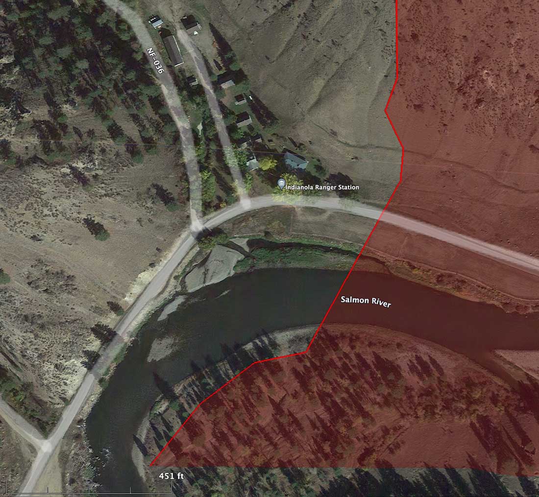
The general area where the CH-47D crashed July 21, 2022. Google Earth. The red shading represents an area burned in the Moose Fire.
There are unconfirmed reports that a hotshot crew was nearby when it crashed and they went into the Salmon River and extricated the pilots in an attempt to save them.
The last time Flight Aware tracked N388FA was at 3:02 p.m. MDT July 21. Because of the rugged terrain, it first showed it north of the Salmon Airport. Then it went northwest generally toward the Moose Fire and lost tracking at 3:12 p.m., minutes before it reached the river.
As an example of the terrain here is a photo of the Comet Fire I took a few years ago from Highway 93 just east of the current Moose Fire, 13 air miles north of Salmon, ID. The Salmon River is in the foreground.
Comet Fire, July 28, 2016. Photo by Bill Gabbert.
The video below was shot at Penticton Airport in British Columbia July 16, 2022 when it stopped for fuel en route from Alaska to Idaho.
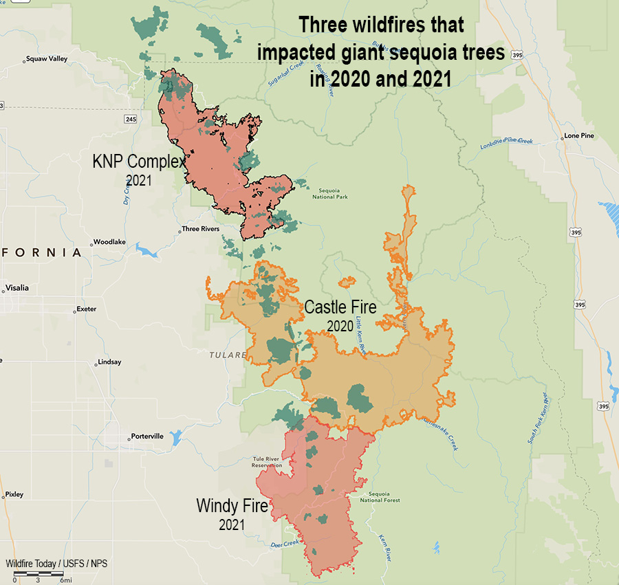
Three fires in two years that killed giant sequoia trees. The darker green areas represent groves of giant sequoias.
The U.S. Forest Service distributed information yesterday saying there are areas still burning in giant sequoia groves after wildfires that occurred in the Castle and Windy Fires of 2020 and 2021.
From the Sequoia National Forest, July 23, 2022:
Three fires were discovered this week, still smoldering inside the 2020 Castle and 2021 Windy Fires. Firefighters from Sequoia National Forest quickly reached two, and the third could not be reached safely due to the dense stand of fire-killed trees surrounding it.
The 1-acre Cougar Fire was found burning in the Red Hill Giant Sequoia Grove near the Tule River Indian Reservation boundary. Less than a half mile away, the ¼-acre Crawford Fire was reported by fire personnel responding to the Cougar Fire. Both were caused by a smoldering giant sequoia tree leftover from last summer’s Windy Fire.
Burning area in giant sequoia grove. US Forest Service. Photo distributed July 23, 2022. (Date of the photo and name of fire not provided)
Fireline was constructed by hand to stop each fire from spreading further. Heavy material: treetops, limbs, and trunks of previous fallen trees continue to smolder underneath these still-standing sequoia trees, weakened by the fire burning inside them. Fire personnel will continue to mop up and extinguish what they can without jeopardizing their safety by having to work under a burning giant sequoia tree. Neither the Cougar nor Crawford Fires pose an immediate risk to nearby communities.
On Thursday, a third fire was reported southeast of Camp Nelson in the Belknap Giant Sequoia Grove. Helicopter personnel located this fire deep inside the burned area of the 2020 Castle Fire. Due to its remote location, numerous standing hazard trees endangering fire personnel, and minimal chance of escape, this fire will be monitored from a distance and by air.
There have been several instances of smoldering trees, most of them large diameter giant sequoias, observed and reported in both the Castle and Windy Fire burned areas. These are likely to continue as dry conditions persist. Firefighter safety is a priority when determining how best to extinguish these types of fires. They may have to be monitored until the trees fall on their own and can be managed safely on the ground.
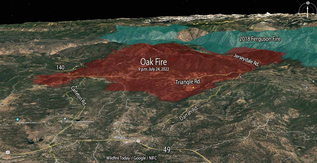
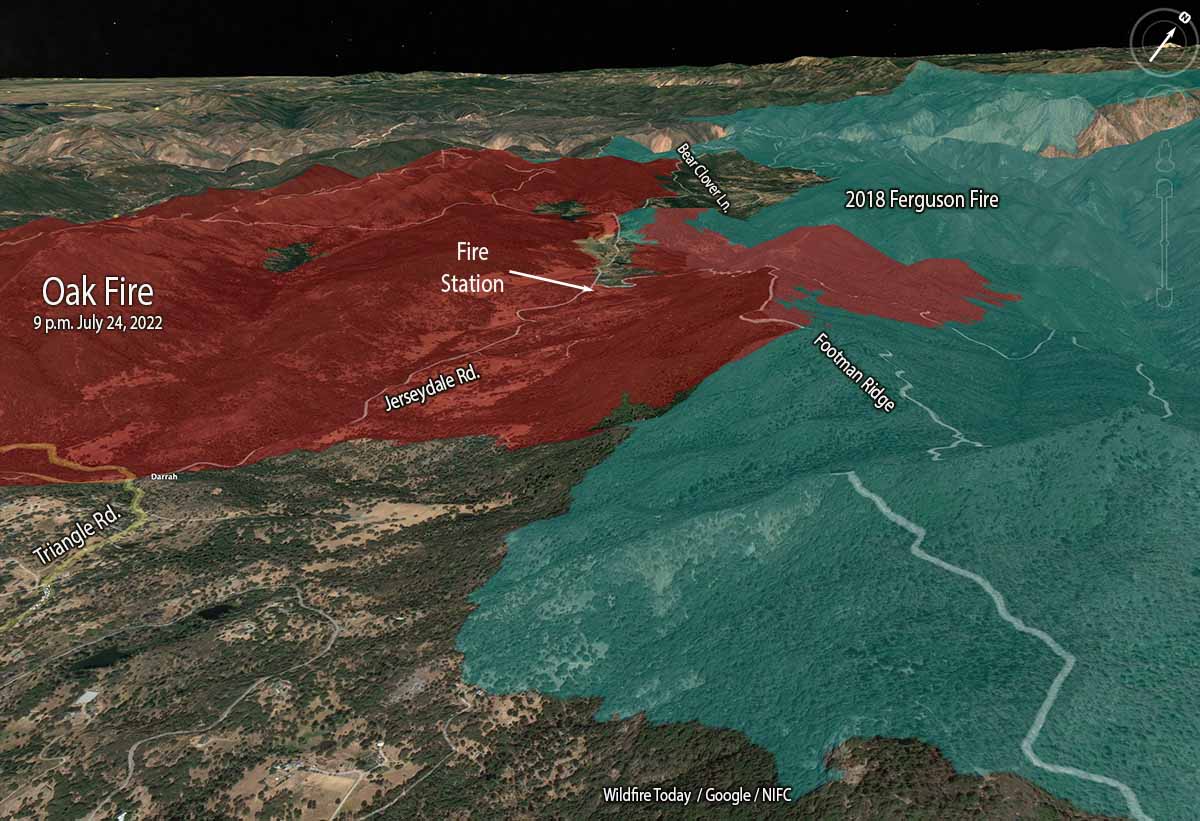
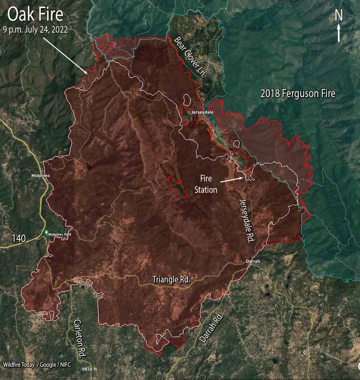
Oak Fire 3-D map, looking north at 9 p.m. July 24, 2022.
The Oak Fire northeast of Mariposa, California was very active Sunday especially on the east side where firefighters worked to minimize the spread beyond Footman Ridge and battled, successfully, to keep it from crossing Bear Clover Lane.
The blaze was mapped Sunday night at 16,791 acres.
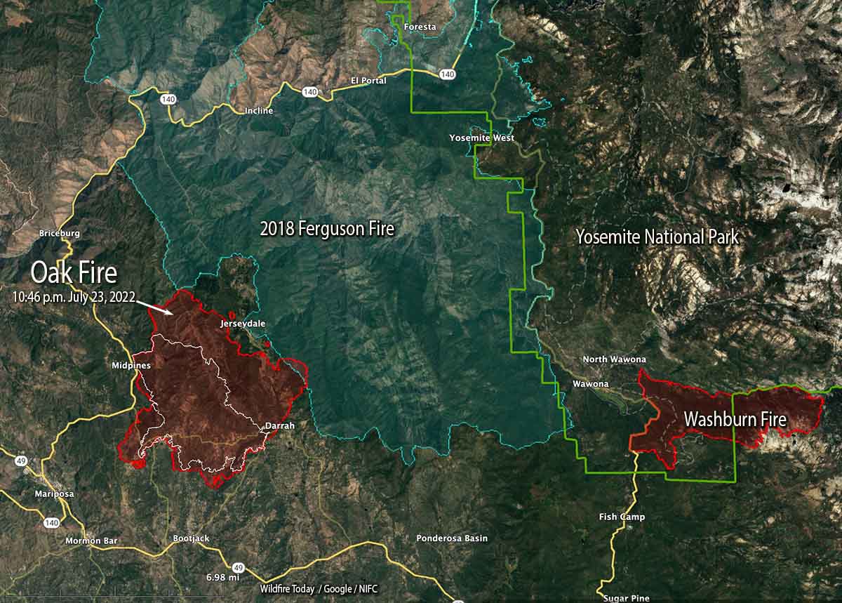
To see all articles on Wildfire Today about the Oak Fire, including the most recent, click HERE.
Part of the western edge of the Ferguson Fire that burned 96,000 acres in 2018 was south of Jerseydale and east of Jerseydale Road. That four-year-old footprint is not stopping the Oak Fire, but the rate of spread and intensity is greatly diminished as it burns, giving firefighters more options to put in direct fireline on the edge where they can, and construct indirect lines out ahead. Drops from helicopters and air tankers are also more effective in the lighter fuels.
Oak Fire 3-D map, east side, looking northwest at 9 p.m. July 24, 2022.
While personnel have their hands full slowing or stopping the spread on the east and north sides, the south and west perimeters are looking much better. Direct fire line has been completed in many areas and tactical burning has helped to secure the edge.
In a community meeting Sunday evening fire officials said that soon after the fire started at 2:10 p.m. Friday it was creating spot fires two miles ahead of the main fire. At that time there was little the limited number of firefighters at the scene could do other than protect lives and structures and help with evacuations.
Oak Fire map. The red line was the perimeter at approximately 9 p.m. July 24, 2022. The white line was the perimeter about 23 hours before.
The number of structures reported as having been destroyed remains at 10, but that number will change after the two-person damage assessment team begins to report their findings, which may be released today.
Resources on the incident include 17 helicopters, 225 fire engines, 58 dozers, 23 water tenders, and 51 hand crews for a total of 2,093 personnel.
Oak Fire, looking northwest from Miami Peak at 7:18 a.m. July 25, 2022.
The video below has excellent footage of air tankers dropping retardant on the Oak Fire. You’ll see in order, DC-10 with a lead plane, BAe-146, DC-10 making a downhill drop, and finally an S-2T.
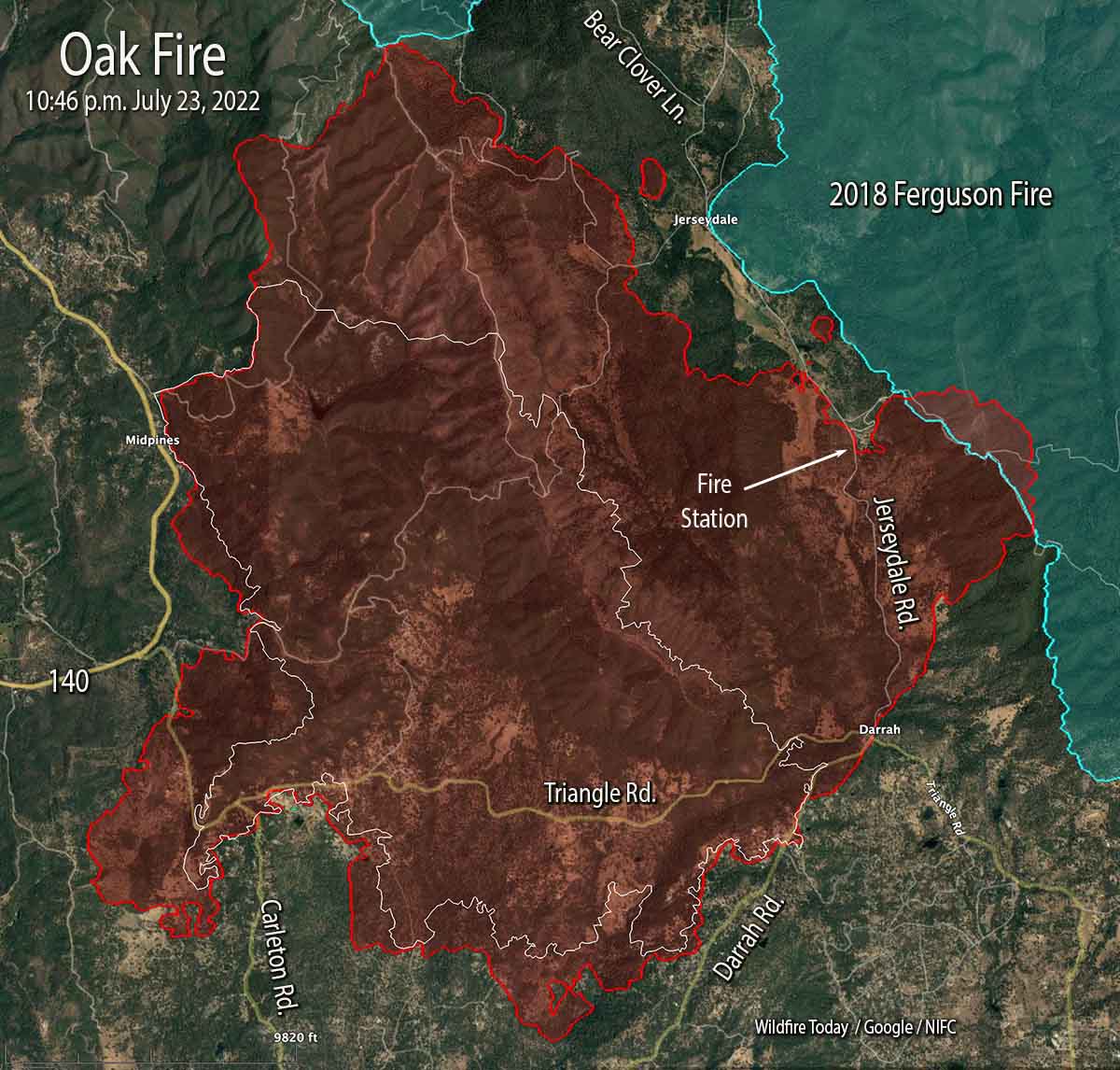
Oak Fire map. The red line was the perimeter at 10:46 p.m. PDT July 23, 2022. The white line was the perimeter at 4 a.m. July 23.
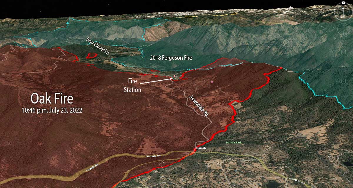
The Oak Fire two miles northeast of Mariposa, California was active on all sides Saturday and into the night. Most of the overnight movement was on the east side which saw the largest growth, spreading for one to two miles east and northeast, crossing Jerseydale road and surrounding a fire station on the road. It moved into the footprint of the Ferguson Fire which burned more than 96,000 acres four years ago.
When the fire was mapped at 10:46 p.m. Saturday night it was spreading toward Bear Clover Lane north of Jerseydale. It was six miles from Yosemite National Park, with the burn scar from the Ferguson Fire in between.
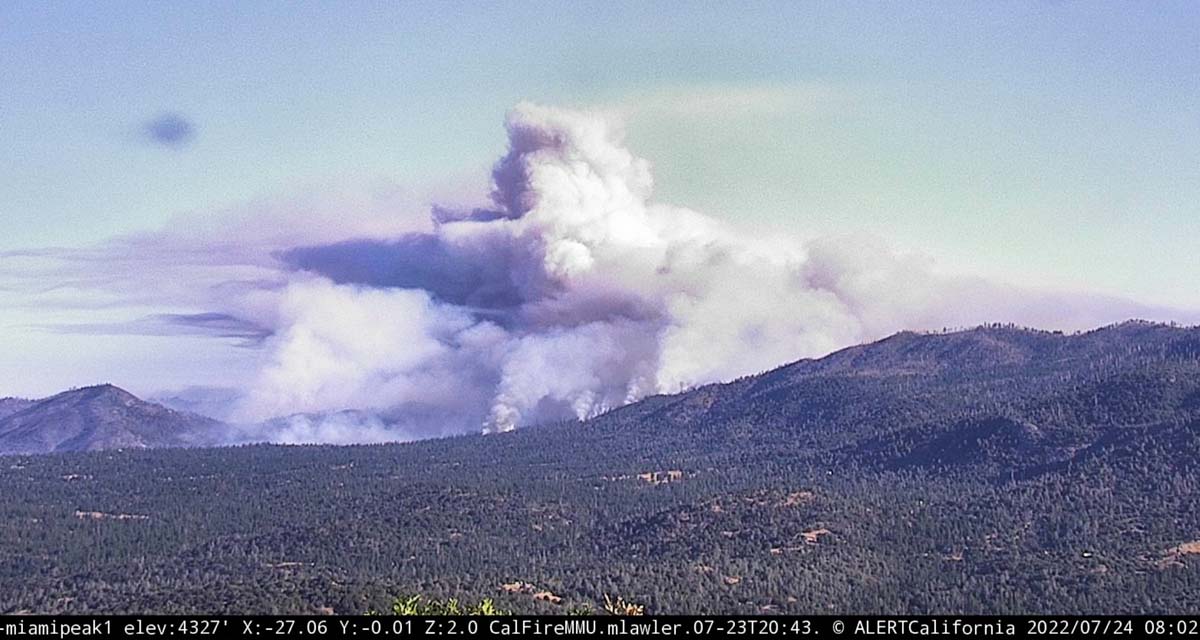
As you can see in the photo below, at 8 a.m. Sunday it was already creating a large plume of smoke.
Oak Fire, as seen from Miami Peak, looking northwest at 802 a.m. July 24, 2022.
CAL FIRE reported Sunday morning at 7 a.m. it had burned 14,281 acres since it started Friday afternoon. The number of structures destroyed remained at 10.
Oak Fire vicinity map. The red line was the perimeter at 10:46 p.m. PDT July 23, 2022. The white line was the perimeter at 4 a.m. July 23.
On the south, it crossed Triangle Road then reached and crossed in some places Darrah Road.
“The fire is moving quickly. This fire was throwing embers out in front of itself for up to 2 miles yesterday,” Daniel Patterson, a spokesman for the Sierra National Forest said Saturday. “These are exceptional fire conditions.”
Oak Fire 3-D map, east side, 10:46 p.m. PDT July 23, 2022.
As of the Saturday night mapping flight the west side has remained east of Highway 140 in the Midpines area.
Evacuations are in effect. Mariposa County maintains a map online showing the affected areas.
Resources assigned include 17 helicopters, 225 fire engines, 58 dozers, 23 water tenders, and 51 hand crews for a total of 2,093 personnel.
Oak Fire, at dawn, July 24, 2022. Courtney Aviation.
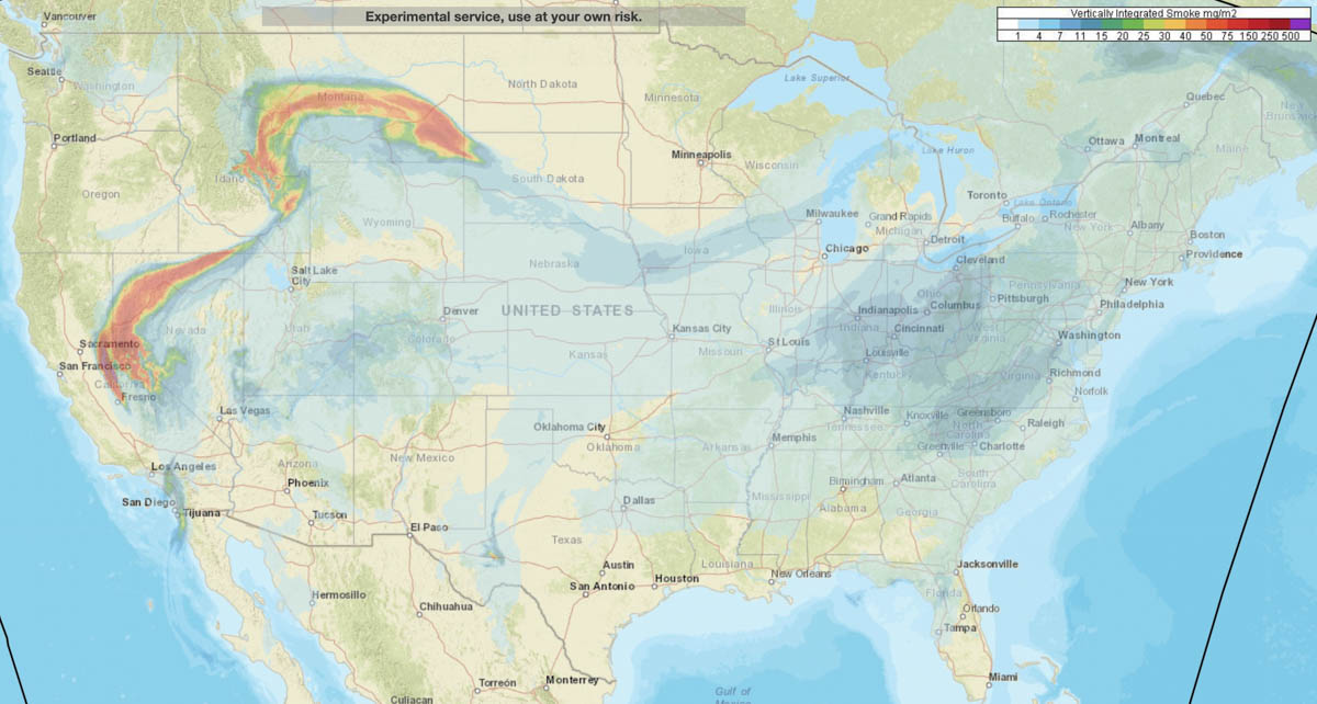
Smoke forecast for the United States at 7 a.m. MDT July 24, 2022. NOAA.
NOAA has produced a forecast for the distribution of vertically integrated wildfire smoke at 7 a.m. MDT Sunday July 24. Locations to be hit the hardest are areas in Northern California, Northern Nevada, Eastern Idaho, and Montana.
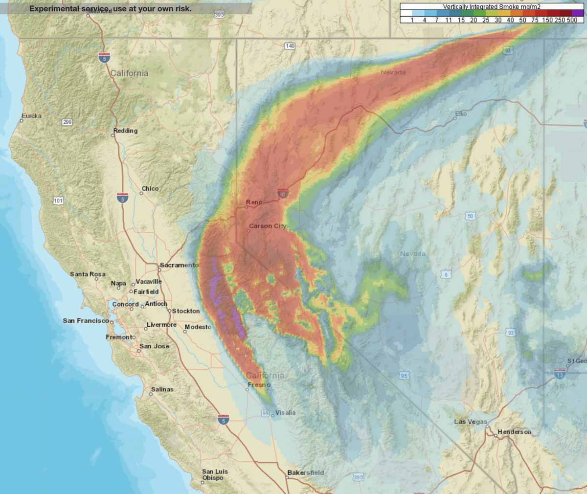
Smoke forecast for Northern California and Nevada at 7 a.m. MDT July 24, 2022.
Most of the 5,000 acres of growth was on the west and east sides
12:12 p.m. MDT July 23, 2022
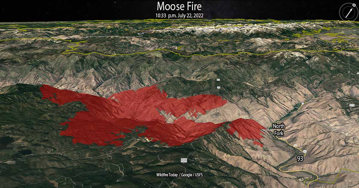
Moose Fire 3-D map looking northwest at 10:33 p.m. July 22, 2022.
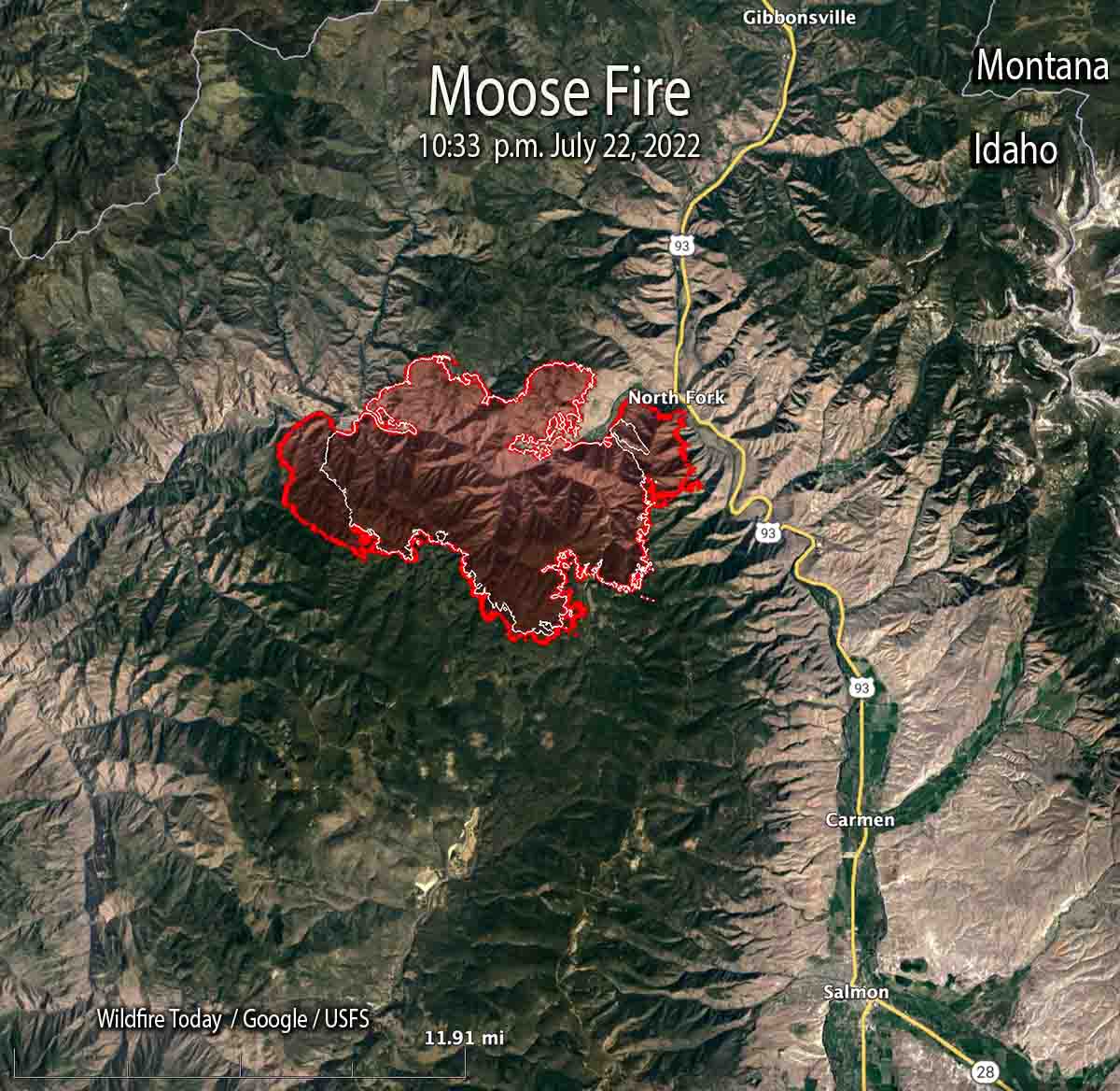
Most of the 5,000 acres of growth of the Moose Fire in eastern Idaho Friday was on the west and east sides, spreading for about a mile to the east and west. Friday night the fire burned actively, spreading west as far as Kayak Camp. In the North Fork area it reached the west bank of the Salmon River. Two miles of the east flank are on the steep slopes west of and above US Highway 93.
Friday’s Red Flag weather conditions increased fire activity along the top of Napoleon Ridge. North of the Salmon River, firefighters succeeded in holding fire line built during the last several days.
At 10:33 p.m. Friday it was mapped at 28,839 acres. At that time it was 12 miles northwest of Salmon, Idaho and 10 miles west of the Idaho/Montana border.
Map of the Moose Fire. The red line was the perimeter at 10:33 p.m. July 22, 2022. The white line was the perimeter 24 hours before.
Two pilots were killed Thursday July 21 when their Chinook helicopter crashed into the Salmon River while working on the fire. They were identified as Thomas Hayes, 41, of Post Falls, Idaho, and Jared Bird, 36, of Anchorage, Alaska. The National Transportation Safety Board will conduct an investigation.
A spokesperson for the Salmon Challis National Forest said the cause of the fire is undetermined.
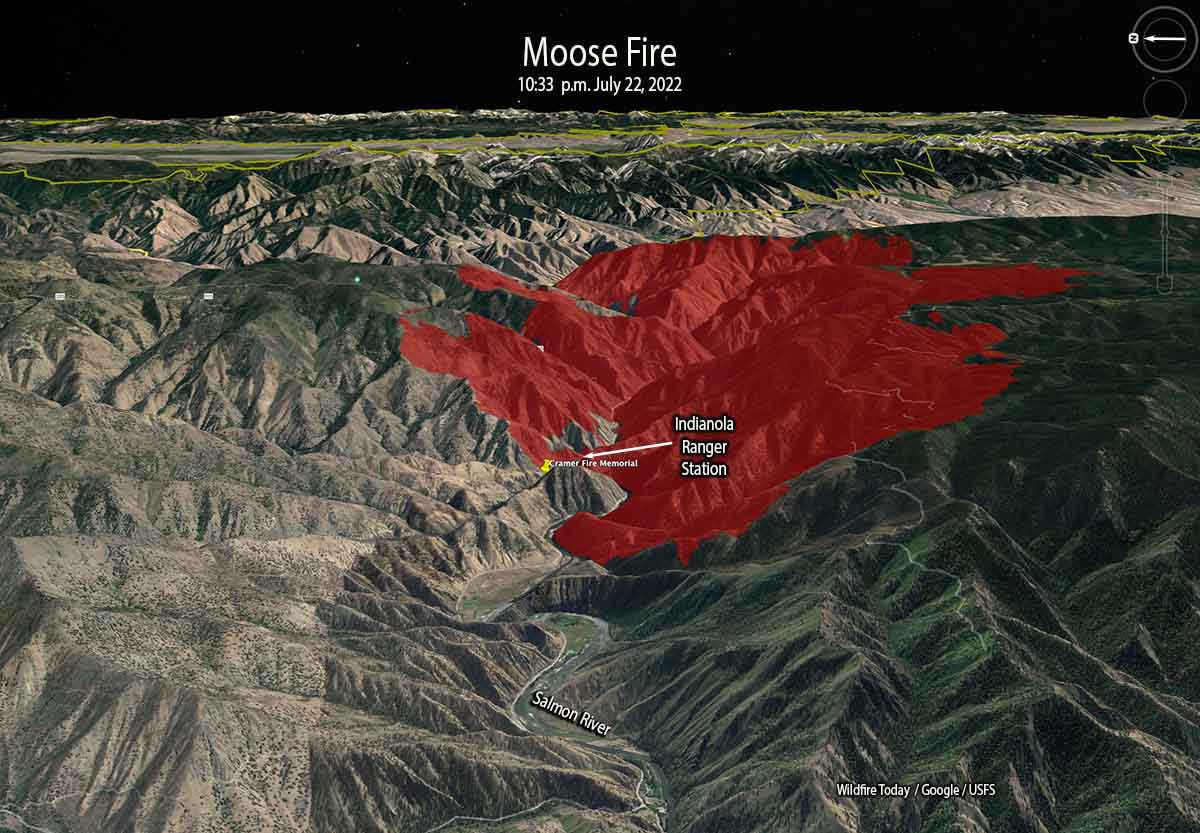
Moose Fire 3-D map looking east at 10:33 p.m. July 22, 2022.
On Saturday firefighters will be holding and improving line around the north end of the fire and protecting structures along Salmon River Road and Highway 93. On the southeast side, crews and heavy equipment will work on building an indirect line along Diamond Creek Road from the Highway 93 corridor up into Five Corners.
At the site of the Indianola Ranger Station along the Salmon River (see map above) there is a memorial to two firefighters who were killed while working on the Cramer Fire July 22, 2003 — Jeff Allen and Shane Heath, members of the Indianola Helitack Crew. More information HERE and HERE.
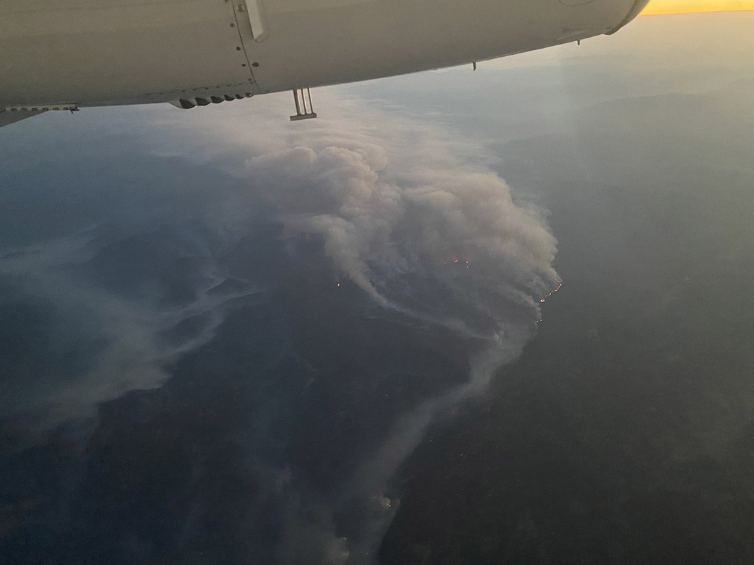
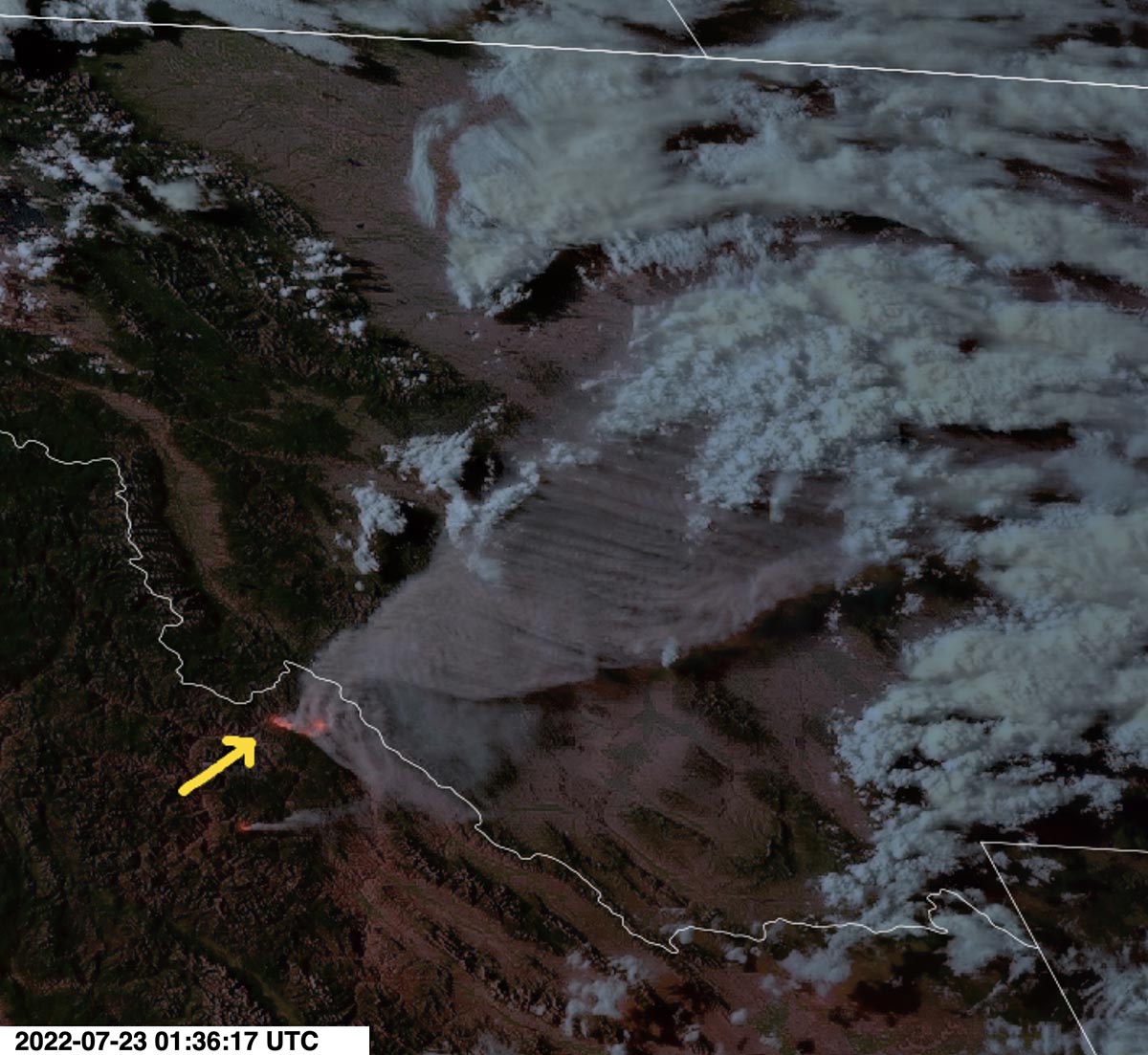
Smoke produced by the Moose Fire in eastern Idaho, as seen from the GOES 17 satellite at 7:36 MDT July 22, 2022.
Weather conditions are expected to moderate Saturday with quieter winds, however it will still be hot and dry for several days.