After the atmospheric rivers, a changing outlook

To interpret a wildland fire outlook can be a bit like posting a scenic photo to Instagram. You share the images and phases that capture the moment, with hopes that these will intrigue us into deeper connections to the months ahead.

AND THE RAIN AND SNOW FELL … From the latest National Significant Wildland Fire Outlook (for February through May 2013, with hints to the future), one image may lay claim to this month’s Instagram shot. The Total Precipitation Anomaly for January 2023 features a piercing finger of deep-green and blue anomalies from the central California coast eastward to upper Wisconsin – this being the precip falling from “multiple moderate to strong atmospheric rivers,” leading to moisture from 150 to more than 400 percent of normal.

January 2023 Precipitation Anomaly.
January 2023 Precipitation Anomaly. https://www.predictiveservices.nifc.gov/outlooks/precip30day.png.

What this means for fire potential long-term is to be determined. Though this was a wide and significant flow, it was not a universal flood. Wide areas are likely to remain in drought yet many regions, including northern California to Oregon and east into Idaho and Montana, are likely to improve, as depicted by the tan (improvement) and green (out of drought) shading in the U.S. Seasonal Drought Outlook through April.
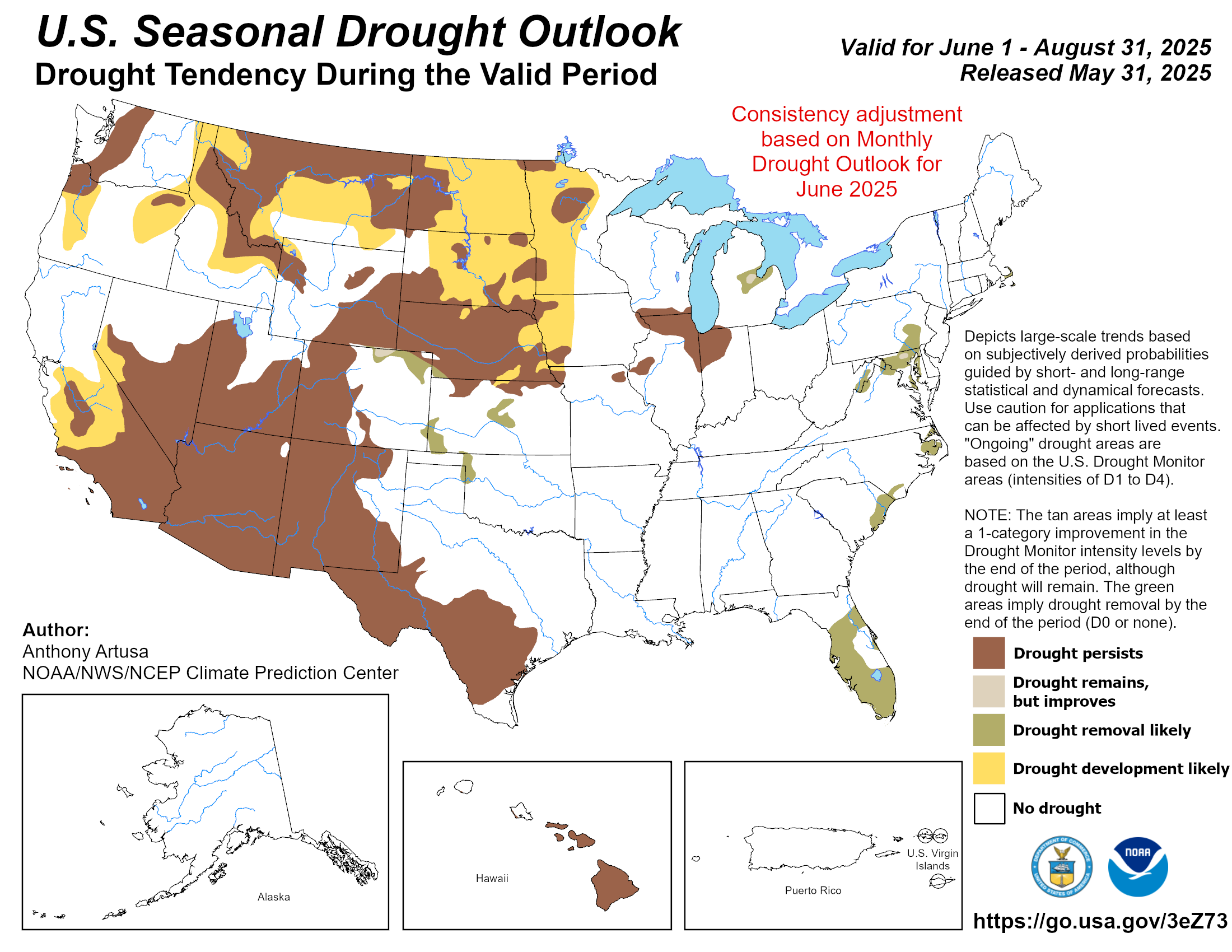
U.S. Seasonal Drought Outlook through April.
U.S. Seasonal Drought Outlook through April. https://www.cpc.ncep.noaa.gov/products/expert_assessment/season_drought.png.

WHAT TO EXPECT: The result of this precip is a fire potential outlook that is nearly Normal by May of 2023, with a slot of Above Normal red from west Texas to central New Mexico and a blob in the Georgia-Florida pinelands.

Significant Wildland Fire Potential Outlook for May 2023.
Significant Wildland Fire Potential Outlook for May 2023. https://www.predictiveservices.nifc.gov/outlooks/month4_outlook.png

WHAT NORMAL LOOKS LIKE … in a typical season, for March into May, fires (including prescribed fires) may be relatively active on the land, particularly in the Southeast and southern Great Plans into the Trans-Pecos and Rio Grande, as illustrated in this map of normal fire activity for April.
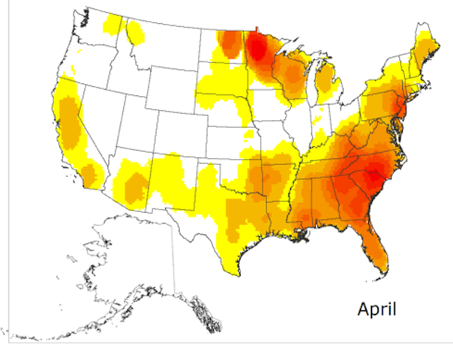
Normal-Fire-Season-Progression-April

Our tracking with “normal” will be influenced by global transitions as we’re likely leaving a record-long period of La Niña conditions. As the Outlook observes: “The Climate Prediction Center (CPC) is forecasting an 82% chance of neutral El Niño-Southern Oscillation (ENSO) conditions returning in spring. Other teleconnection patterns, such as the Madden-Julian Oscillation, Pacific Decadal Oscillation, Pacific-North American Pattern, and Arctic Oscillation are likely to influence weather and climate during the outlook period.” But we’re not through with the cool-ocean pattern yet: “La Niña is forecast to remain the dominant influence through February.”

So expect some variability to be foretold, as fuels grow into green-up and cure into summer.

For more, see the NIFC Predictive Services’ National Significant Wildland Fire Potential Outlook for February through May 2023.

Update on the snow drought

The snow water equivalent is below 50 percent in parts of the southwestern quarter of the U.S.

Snow Drought, April 11, 2021
Snow Drought, April 11, 2021.

I learned years ago that it is folly in February, March, or April to attempt to predict the outcome of the summer/fall wildfire season in the Western United States. If the weather in the summer is relatively cool and wet, the fire season will not be extremely busy.

Having said that, a glance at the snow water equivalent dated April 11 shows that it is far below normal in the Western states except for Washington, Oregon, Montana, and northern Idaho.

It is below 50 percent in some areas of California, Utah, Arizona, South Dakota, and New Mexico. In southeast Arizona it is zero to four percent of average.

Couple that with the higher than average temperatures and lower than average precipitation expected in some of these areas and, dare I say it, if the predictions are correct, there could be more wildfire activity than average in the southwestern one-quarter of the U.S. this year.

The following outlooks were produced about three weeks ago, so they should be taken with a grain of salt.

Precipitation outlook May through July, 2021
Precipitation outlook May through July, 2021.
Precipitation outlook, May through July, 2021
Precipitation outlook, May through July, 2021.

Forecasters expect a warm Fall in the United States

Temperature outlook, September through November, 2017
Temperature outlook, September through November, 2017.

Weather forecasters just released their three-month outlook for September through November in the United States. If correct, it will be warmer than normal across the entire country and the precipitation will be close to average except in the Southeast where they expect wetter conditions. This could lead to extended Autumn wildfire seasons.

Precipitation outlook, September through November
Precipitation outlook, September through November, 2017.

Wildfire potential February through May

On February 1 the Predictive Services section at the National Interagency Fire Center issued their Wildland Fire Potential Outlook for February through May, 2016. The data represents the cumulative forecasts of the ten Geographic Area Predictive Services Units and the National Predictive Services Unit.

If their forecasts are accurate it looks like mild fire potential until April and May when conditions could become more favorable to the spread of fires in the Midwest and south-central Alaska. Hawaii could become busy starting in February or March.

Here are the highlights from their outlook.

February

February wildfire potential

  • Below normal significant fire potential will persist across most of the Southeastern U.S., mid-Atlantic and Puerto Rico as El Nino storm systems continue to bring significant moisture to most of these areas.
  • Significant fire potential is normal across the remainder of the U.S., which indicates little significant fire potential.

March

March wildfire potential

  • Below normal significant fire potential will continue across most of the Southeastern U.S., mid-Atlantic and Puerto Rico as El Nino continues to bring significant moisture.
  • Above normal fire potential will also develop across the Hawaiian Islands thanks to long term drought.
  • Significant fire potential will remain normal across the remainder of the U.S., though potential for pre-greenup fire activity increases through early spring.

April and May

April May wildfire potential

  • Above normal significant fire potential will develop across the Great Lakes into the Ohio and Tennessee Valleys where less precipitation has occurred.
  • An area of above normal fire potential is also likely to develop across south central Alaska because warm temperatures and rain have limited snowpack.
  • Above normal fire potential will continue across the Hawaiian Islands as drought persists. Below normal significant fire potential will continue across most of the Southeastern U.S. and Puerto Rico.
  • Significant fire potential continues normal across the remainder of the U.S.

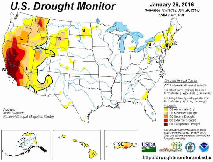
In addition to NIFC’s outlook, here’s bonus #1: the Drought Monitor released January 28, 2016.

Drought Monitor 1-28-2016

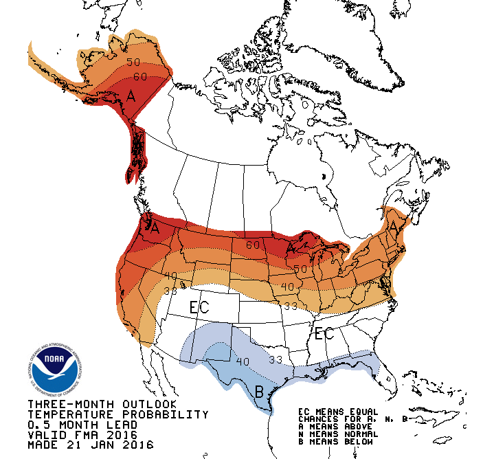
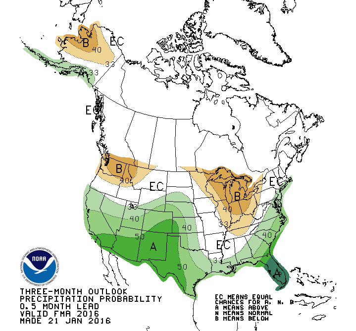
Bonuses #2 and #3, 90-day temperature and precipitation outlooks:


90 day temperature outlook

=================

90 day precipitation outlook