Strong winds push Woodbury Fire north and east

Firefighters have been burning out from structures and roads — evacuations are still in place

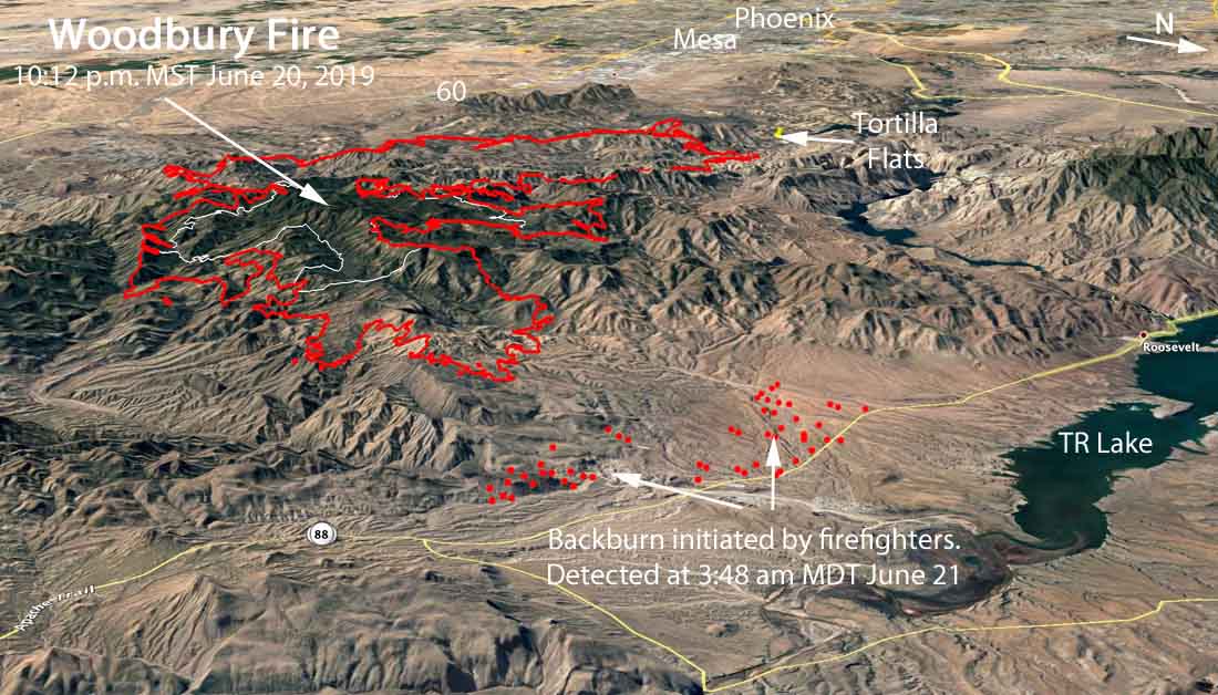
3-D map Woodbury Fire
3-D map of the Woodbury Fire looking west. The red line was the perimeter at 10:12 p.m. MDT June 20. The red dots represent heat detected by a satellite at 3:48 a.m. MDT June 21. Click to enlarge.

For the last several days most of the growth of the Woodbury Fire east of Phoenix has been to the east and northeast, but variable strong overnight winds caused a previously quiet area of the fire to spread significantly to the north.  During a 3:48 a.m. MDT satellite overflight on Friday the fire had come to within 2 miles of Apache Trail about nine air miles east of Tortilla Flat. (See the map, above, of the Woodbury Fire)

The night shift that included four Hotshot Crews conducted burnouts on the east side of Highwa 188 six miles southeast of the community of Roosevelt northeast of the junction with Desert to Tall Pines Highway, and in other locations where needed to protect infrastructure.

(To see all articles on Wildfire Today about the Woodbury Fire, including the most recent, click HERE.)

The fire is not being fully suppressed. Instead, a variety of strategies are being used.

At about 10 p.m. on Thursday the fire was mapped from an aircraft at 65,903 acres but it continued spreading vigorously after that fixed wing flight.

Resources assigned to the fire include at least 21 hand crews, 28 engines, 8 helicopters and an unknown number of air tankers, for a total of  1,112 personnel. One of the air tankers, a DC-10, reportedly flew four missions Thursday dropping a total of 37,000 gallons of fire retardant. Approximately $10.9 has been spent on the fire so far.

On Thursday the fire continued moving through Reevis Creek into the Two Bar area. Additional significant growth was observed near the Reevis Mountain School, Granite Mountain near Little Campaign Creek, and the Blackberry Spring area. The fire is also in the west fork of Pinto Creek which prompted crews to burnout around the Rock Springs Barn and Corrals as well as the Miles Ranch Trailhead.

Structure protection is now in place at Top of the World and the Roosevelt area. This includes building firelines and prepositioning hose lays and portable water sources.

map Woodbury Fire Arizona Phoenix
Map of the Woodbury Fire. The red line was the perimeter at 10:12 p.m. MDT June 20. The red dots represent heat detected by a satellite at 3:48 a.m. MDT June 21.

State Highway 88 is closed from milepost 213 at Tortilla Flat to State Highway 188 at Roosevelt. State Highway 188 is closed from State Highway 88 just west of Roosevelt at milepost 244 to State Highway 288. For current Arizona Department of Transportation information visit https://az511.gov/.

For information about evacuations, shelters, livestock and pet shelters call: 928-402-8888.

The weather forecast for the Roosevelt area on Friday calls for 88 degrees, southwest winds of 17 mph gusting to 24, and relative humidity of 19 percent. The weather on Saturday should be about the same.

A Red Flag Warning for extreme fire weather is in effect through Friday evening for the northeast part of Arizona just outside of the Woodbury Fire area. Much of New Mexico is also under a Red Flag Warning through Saturday evening.

Woodbury Fire causes evacuations at Roosevelt, Arizona

Wednesday night the fire was mapped at 50,595 acres.

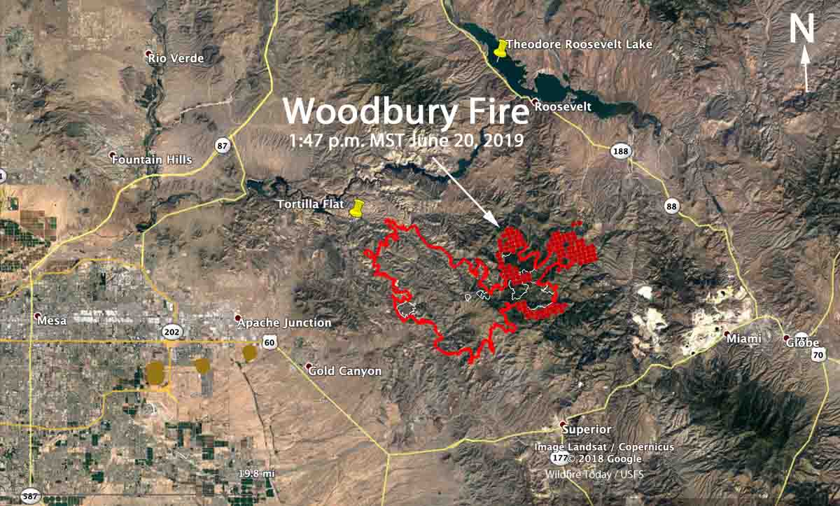
Woodbury Fire wildfire map June 20 2019
Map of the Woodbury Fire. The red line was the fire perimeter at 11 p.m. MST June 19. The white line was the perimeter about 48 hours before. The red dots represent heat detected by a satellite at 1:47 p.m. MDT June 20, 2019. Click to enlarge.

At 1 p.m. local time June 20 the the Gila County Sheriff’s Office announced an “evacuation alert” for two areas northeast of the Woodbury Fire, Roosevelt and Roosevelt Lake area:

All residents are asked to GO at this time. Go! Evacuate Now. If you are unable to evacuate, call 911.

The west side of the Woodbury Fire is about 12 miles east of the suburbs of Phoenix. Winds over the last several days have pushed the blaze to the east and northeast. At 5 p.m. on Thursday the temperature at a weather station east of Tortilla Flat recorded temperatures in the mid-90s, relative humidity of 10 percent, and WSW winds of 14 mph gusting to 23 mph. The forecast for Tortilla Flat for Friday predicts about the same. (See the map, above, of the Woodbury Fire)

(To see all articles on Wildfire Today about the Woodbury Fire, including the most recent, click HERE.)

Wednesday night the fire was mapped at 50,595 acres. Officials at the Tonto National Forest are not attempting to completely suppress it, but instead are using a variety of strategies.

Satellite photo of smoke from Woodbury Fire
Satellite photo of smoke from the Woodbury Fire at 5:36 p.m. MDT June 20, 2019.

Smoke from fires in Arizona affects New Mexico and Texas

satellite photo fires wildfires smoke Arizona
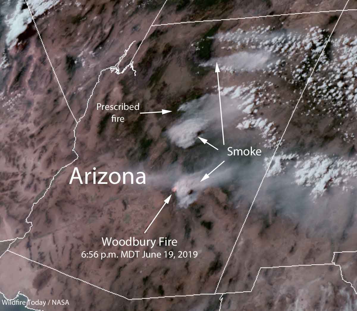
Satellite photo, at 6:56 p.m. MDT June 19, 2019 showing smoke from a prescribed fire and wildfires in Arizona.

Smoke from a prescribed fire southwest of Flagstaff, the Woodbury wildfire east of Phoenix, and other wildfires in northern Arizona was photographed from a satellite at 6:56 p.m. MDT June 19, 2019.

Much of the smoke is blowing into New Mexico and Western Texas.

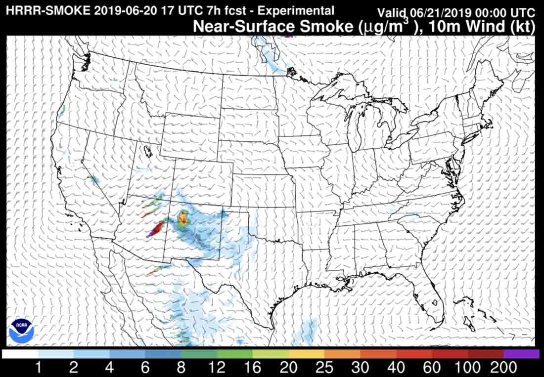
fire smoke map arizona new mexico
Forecast for the distribution of smoke from fires, at 6pm MDT June 20, 2019.

Woodbury Fire in Arizona adds another 4,000 acres

The fire is 12 miles east of the Phoenix suburbs

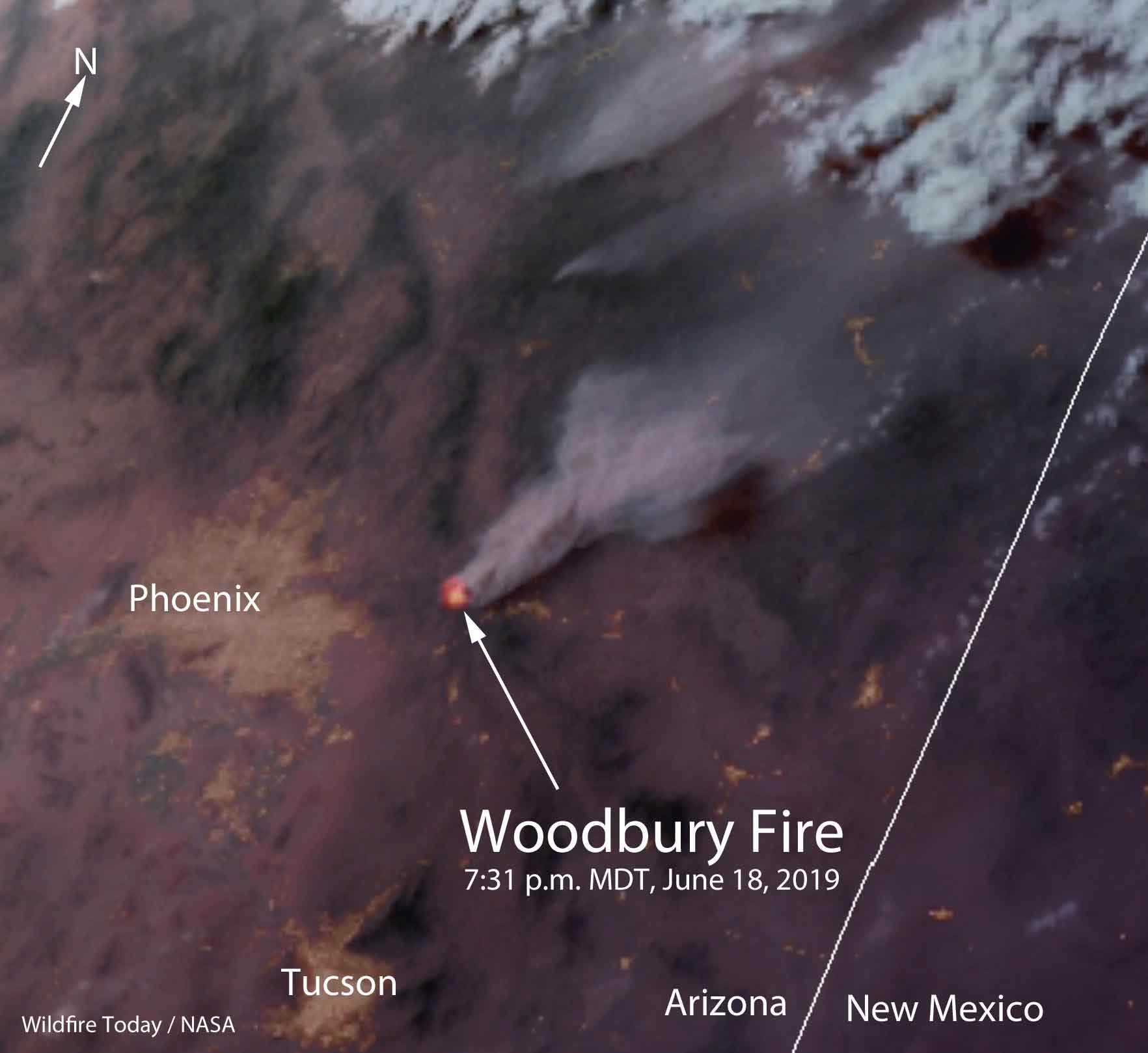
satellite photo Woodbury Fire Phoenix Arizona
Satellite photo of smoke from the Woodbury Fire east of Phoenix, Arizona at 7:31 p.m. MDT, June 18, 2019.

(To see all articles on Wildfire Today, including the most recent, click HERE.)

The Woodbury Fire 12 miles east of the Phoenix suburbs became very active on the northeast side Tuesday beginning at about 2 p.m., sending up another large column of smoke that blew off to the northeast. It added another 3,894 acres to bring the total up to 44,451 acres.

Tanker 101 tanker 914 Woodbury Fire phoenix
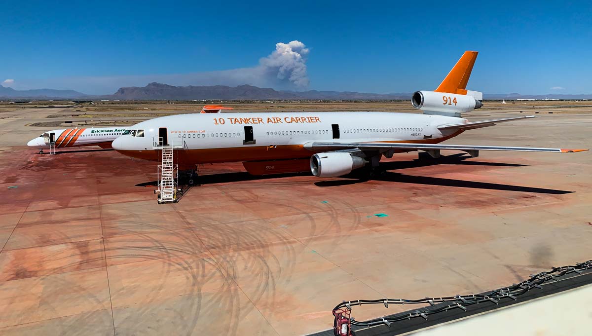
The convection column at the Woodbury Fire shows the beginning of condensation at the top, becoming a pyrocumulus cloud. Tanker 914, a DC-10 is in the foreground, with Tanker 101, an MD87. Photo taken at Phoenix Gateway Airport at 3:18 p.m. MST June 18, 2019. Photo by Ty Miller.

On Wednesday fire crews are preparing for the possibility of the fire moving north towards Roosevelt and east towards the Pinto Mine along Pinto Canyon. Firefighters will be using burnouts and existing black lines to divert fire from the Reavis Ranch, Roosevelt, and mining operations. They will continue the preparations along 500 KV power lines to make them more defensible, masticating brush and building bulldozer lines where appropriate.

Map of the perimeter Woodbury Fire Phoenix Arizona
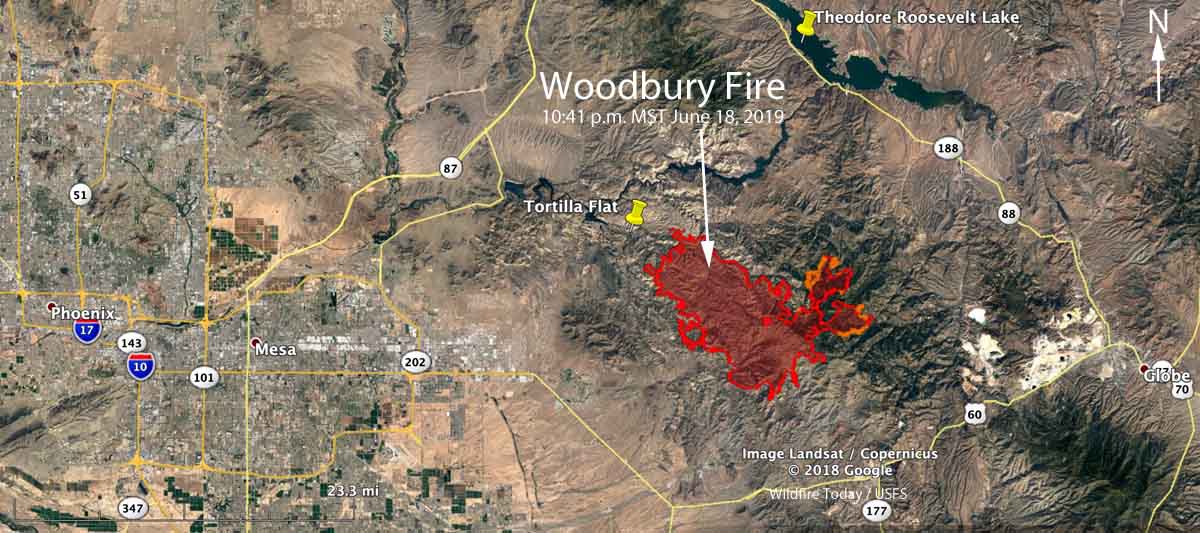
Map of the perimeter of the Woodbury Fire at 10:41 p.m. MST June 18, 2019.

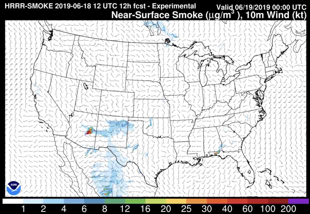
The smoke is expected to spread to the east on Saturday, becoming noticeable in Southern New Mexico and Western Texas.

wildfire smoke forecast June 19, 2019
The smoke from the Woodbury Fire is expected to blow off to the east on Wednesday into Southern New Mexico and Western Texas. The map depicts the forecast for 6 p.m. MDT June 19, 2019.

Comparing the Woodbury Fire with the five largest in Arizona

Woodbury Fire compared to 5 largest fires in state

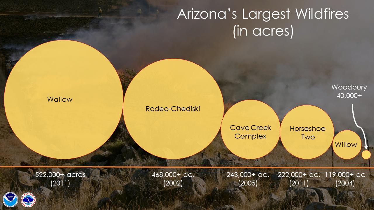
The 40,000-acre Woodbury Fire 12 miles east of the Phoenix suburbs is large, but it is nowhere near as big as the five largest in the recorded history of the state, according to the graphic prepared by the Phoenix office of the National Weather Service.

More information about a couple of these fires: Wallow Fire and Horseshoe Two Fire.

(To see all articles on Wildfire Today about the Woodbury Fire, including the most recent, click HERE.)

Woodbury Fire east of Phoenix grows to over 40,000 acres

3-D map of the Woodbury Fire
3-D map of the Woodbury Fire mapped at 10:20 p.m. MST June 17, 2019. Looking west toward Phoenix. Wildfire Today. Click to enlarge.

The Woodbury Fire 12 miles east of the Phoenix suburbs has burned 40,557 acres, mostly in the Tonto National Forest in the 11 days since it started. The agency is not attempting to completely suppress it, but instead is using a variety of strategies.

(To see all articles on Wildfire Today about the Woodbury Fire, including the most recent, click HERE.)

The weather forecast for the fire area over the next seven days looks very static, with high temperatures in the Tortilla Flat area around 100 degrees and no expectation of precipitation. The wind should be about 8 to 10 mph out of the south and southwest during the daylight hours.

Resources assigned to the fire include 18 hand crews, 34 engines, and 6 helicopters, for a total of 747 personnel.

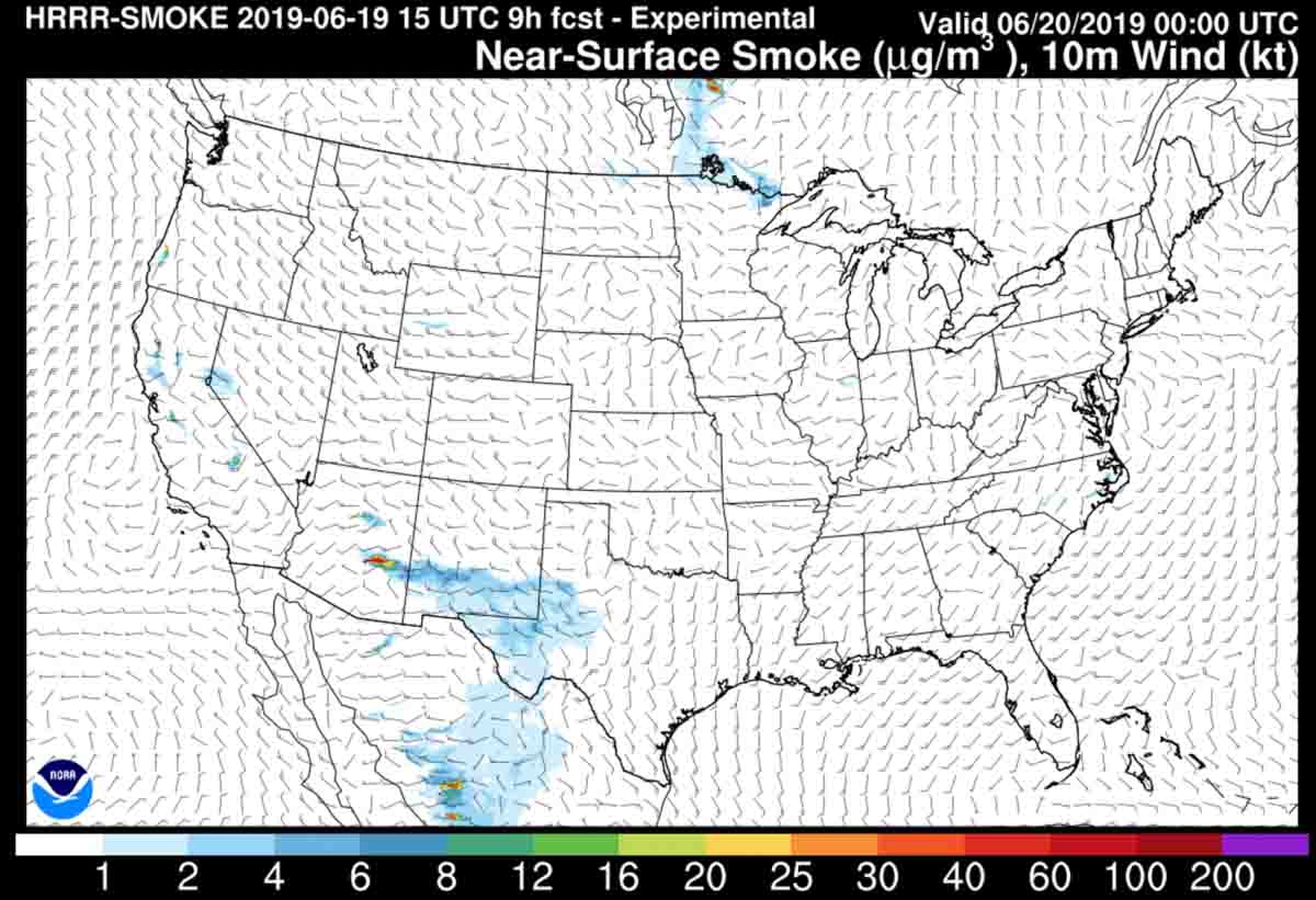
The smoke forecast for 6 p.m. MDT on Tuesday shows the smoke plume from the fire being pushed off to the northeast, away from the greater Phoenix metropolitan area.

wildfire smoke forecast
Forecast for the distribution of smoke from wildfires at 6 p.m. MDT June 18, 2019.

Below is a summary of Monday’s activities released by the Incident Management Team at 9 p.m. on Monday.


[Monday]: Early this morning helicopters used aerial ignition and began a low intensity fire in the Reavis Ranch area to reduce vegetation in front of the advancing fire. These efforts were taken to protect Mexican spotted owl habitat, some stands of ponderosa pine and an old apple orchard As predicted, the fire moved east through the area today from Iron Mountain/Angel Basin, creating a large smoke plume and dropping ash as far as the communities of Tonto Basin and Roosevelt. While increased smoke and ash will continue in coming days, at this time there are no evacuations in place for these communities. All evacuation notices, if needed, will come directly from the Gila County Sheriff’s Office.

Heli-rappellers and hotshot crews joined efforts to fight fire near Hewitt Ridge today. The hotshots will remain in the area overnight. Other hotshots completed suppression efforts in the Buzzard Roost area along the boundary of Forest and State lands. Retardant drops in the Coffee Flat /Valley Canyon area were effective in preventing fire spread; crews will be used to reinforce the line as needed. All of these suppression actions help tie together a contiguous line around the fire, and stop its spread southwest towards State and private lands, and local communities. Retardant and water drops were also used successfully in other areas of the fire.

Structure protection and fuels reduction efforts continue on the north boundary of the fire along State Highway 88, including mowing of roadside fuels in the road corridor and around power transmission poles. Heavy equipment is being used on the northeast and east sides of the fire to improve roads and protect the 500 KV lines that provide power for Phoenix. Protection for other infrastructure is in development.

Closures: State Highway 88 is closed from Needle Vista east to the junction of State Highway 88 and State Highway 188. This includes Tortilla Flat, Canyon Lake, Apache Lake, and campsites along State Highway 88.

map of the Woodbury Fire
Map of the Woodbury Fire mapped at 10:20 p.m. MST June 17, 2019. Wildfire Today.
Satellite photo Woodbury Fire
Satellite photo of the Woodbury Fire at 6:06 p.m. MDT June 17, 2019.