Helicopter refilling water bucket on Cedar Fire. Undated & uncredited photo from InciWeb.
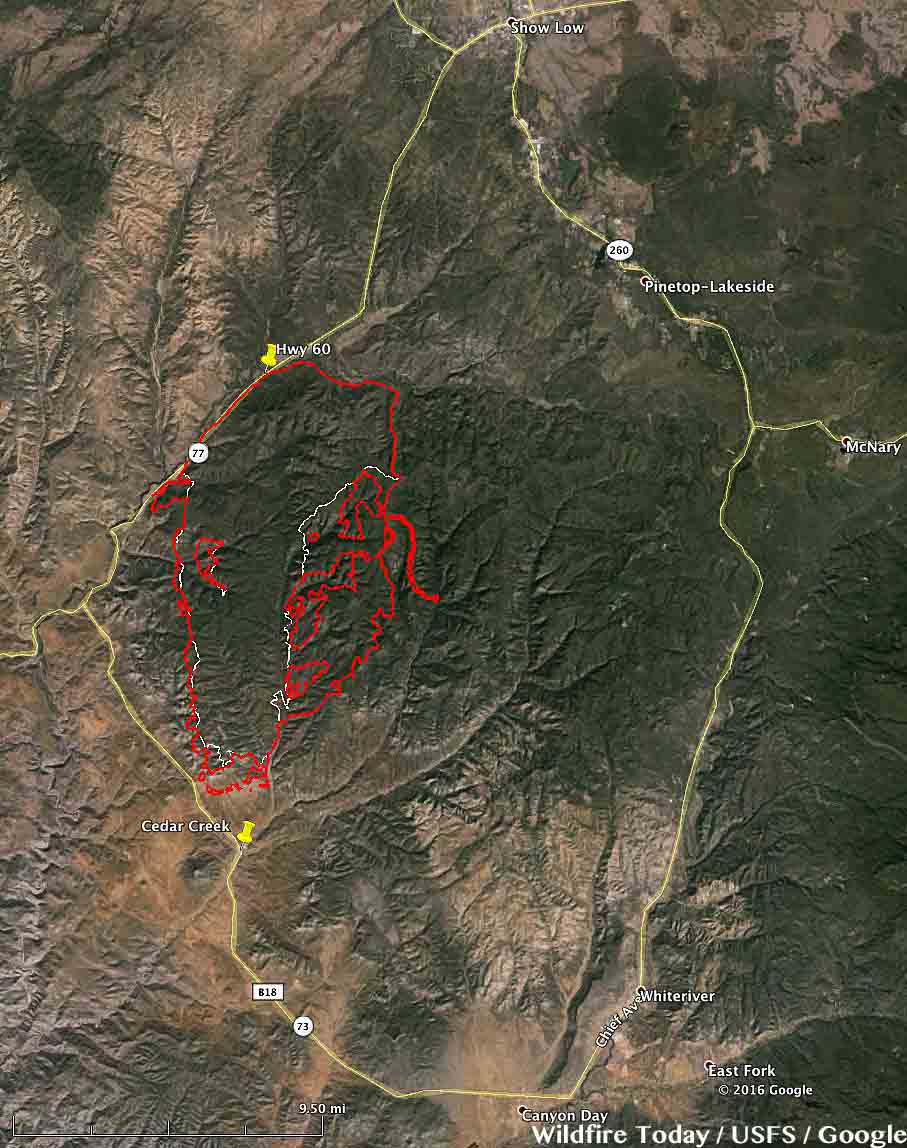
The Cedar Fire south of Show Low, Arizona continues to spread across the Arizona landscape. The Incident Management Team reports that it has burned 45,918 acres, an increase of about 5,000 acres over the last two days. Firefighters still have miles of open fire perimeter and have been working on constructing firelines and conducting burnouts on the east and west flanks.
Map of the Cedar Fire perimeter at 9 p.m. MDT June 23, 2016.
SR-60 between Carrizo and Show Low remains closed due to smoke conditions as firefighters actively work near the highway. SR-73 through Whiteriver remains open from Carrizo to Hon-Dah.
****
(UPDATED at 9:42 a.m. MDT June 22, 2016)
3-D Map of the Cedar Fire at 10 p.m. MDT June 21, 2016. Looking north.Click to enlarge.
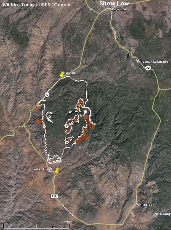
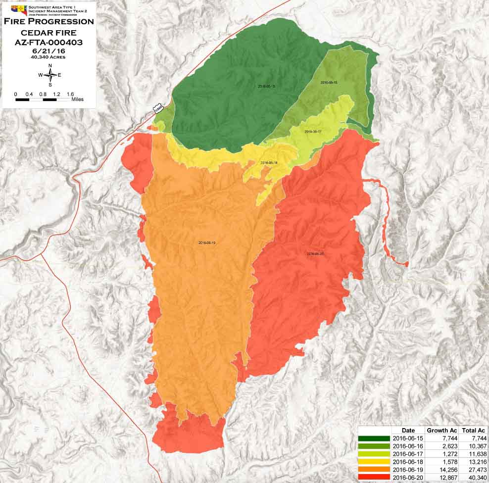
The Cedar Fire south of Show Low Arizona added another 5,000 acres on Tuesday to bring the number acres burned up to 40,340, according to the Southwest Geographic Area Coordination Center. Most of the growth was on the east side, and on the west side near Highway 60.
The southern perimeter is still approximately 1 1⁄2 miles north of Highway 73, and approximately 2 miles north of the Cedar Creek community. The north side of the fire remains fairly quiet.
The brown shaded areas show the additional growth of the Cedar Fire as of 10 p.m. MDT June 21, 2016. The white line is the perimeter from 24 hours before. Click to enlarge. Progression map of the Cedar Fire, June 21, 2016. Click to enlarge.
****
(UPDATED at 8:20 a.m. MDT, June 21, 2016)
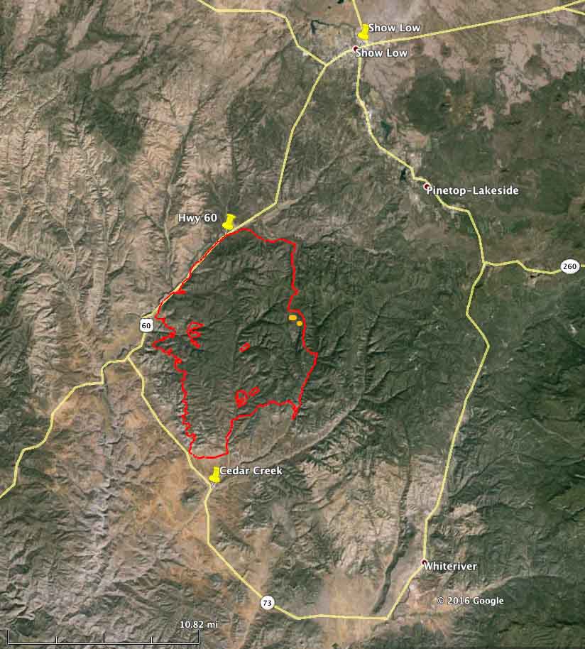
The red line was the perimeter of the Cedar Fire at 4:13 a.m. MDT June 21, 2016. The white line was the perimeter from about 24 hours before. Click to enlarge.
The Cedar Fire south of Show Low, Arizona continued to grow substantially on Monday adding another 9,000 acres to bring the total burned area up to about 35,000 acres. The fire was active on the southwest and south sides, but was extremely active on the east side where it spread over two miles further east.
Above: map showing three large columns of smoke in Arizona and New Mexico, at 5:15 p.m. MDT, June 15, 2016.
The satellite photo above shows three large columns of smoke in Arizona and New Mexico. We have tentatively identified them, but this is not yet confirmed, as the North Fire (25 miles southwest of Magdalena, NM), the Dog Head Fire (about 25 miles southeast of Albuquerque, NM), and the Cedar Creek Fire, a new fire 12 to 16 miles southwest of Show Low, Arizona.
The North Fire is a limited suppression fire, while the other two are being fully suppressed.
The Cedar Creek Fire started around noon on Wednesday and by 3 p.m. had burned about 1,000 acres. Strong winds were pushing it toward Show Low. Fire officials have identified a trigger point. If the fire reaches the B65 Road they will order evacuations of Show Low and Forestdale.
Above: Dog Fire, June 14, 2016. Photo by Incident Management Team.
Cool, wet weather has slowed wildfire activity in Northern California, Washington, and Oregon. The 2,396-acre Pony fire on the Klamath National Forest, about 15 miles southwest of Happy Camp, received rain on Tuesday.
It is a different story in Arizona and New Mexico where more than half a dozen fires have burned significant acreage. All of them are limited suppression fires except for the Dog Head Fire that started Tuesday morning.
Jack Fire
This limited suppression fire has burned 36,408 acres in central Arizona 24 miles southeast of Sedona. This is an increase of about 11,000 acres over the last three days. There is a red flag warning in effect from 11 a.m. Wednesday morning to 7 p.m. in th evening due to strong winds and low relative humidity for the area. Higher temperatures and low relative humidity are expected over the next couple days.
Dog Head Fire
Rich Nieto’s Type 2 Incident Management Team will assume command of this 682-acre fire Wednesday evening. It started at 11 a.m. on Tuesday and as of Wednesday morning voluntary evacuations are occurring for Monzano Morning, Aceves Road, and La Parra Road.
Today they expect temperatures in the 80s and low 90s, southwest wind of 10 to 25 with gust to 35, and relative humidity around 10 percent.
It is about 25 miles southeast of Albuquerque, New Mexico on the Cibola National Forest and National Grassland. This is the only one of these six fires that is not a limited suppression fire.
McKenna Fire
This limited suppression fire northwest of Silver City, New Mexico has burned 10,210 acres since it was reported on May 6.
North Fire
This limited suppression fire has burned about 22,000 acres 25 miles southwest of Magdalena, New Mexico since it was reported on May 21.
North Fire. Undated photo by Ken Watkins.
Spur and Turkey Fires
The Gila National Forest in southwest New Mexico is releasing very little information about these two limited suppression fires that at last report had each burned between 2,000 and 3,000 acres.
The Tenderfoot Fire at Yarnell, Arizona grew slowly on Saturday and is now at 4,040 acres, according to the incident management team. Fire activity was moderated by moisture received on the fire Friday night, along with cooler daytime temperatures and higher relative humidity.
Incident Commander Sinclair stated that “work of the heavy air tankers made a significant contribution towards reducing the spread of fire on the north side of the incident yesterday”.
Highway 89 is now open and the mandatory evacuation on the east side of Yarnell was lifted at 6 p.m. on Saturday. There are no other evacuation orders in effect.
Resources assigned include 8 hand crews, 22 engines, 5 helicopters, 3 dozers, and 353 personnel.
****
(UPDATED at 9:18 p.m. MDT June 10, 2016)
The Incident Management Team provided some updated information Friday afternoon about the Tenderfoot Fire at Yarnell, Arizona:
The fire is currently moving away from the Community of Yarnell in a northeasterly direction, an area where very few structures are present. This area is very rugged in character with very little access. Fire managers will be looking for opportunities to the northeast of the current fire area where firefighters can safely engage and suppress the fire south of Wagoner Road.
There are currently no immediate threats to structures. Over the last few years fuel reduction projects were completed on the east and north sides of the Community of Yarnell. Fire Chief Ben Palm stated that these fuel breaks significantly reduced the fire intensity of the Tenderfoot Fire as it approached the community, allowing firefighters to attack the fire and greatly reduce property loss. The fuel breaks were the result of a partnership between the Community and Arizona State Forestry and the Bureau of Land Management.
This afternoon the Yavapai Sheriff’s Office announced the opening of State Highway 89 at 4:00 p.m.
****
(UPDATED at 8:45 a.m. MDT, June 10, 2016)
Tenderfoot Fire, June 9, 2016. InciWeb photo.
The Tenderfoot Fire at Yarnell, Arizona was very active Thursday afternoon and Thursday night, more than doubling in size to approximately 3,300 acres according to information released by the incident management team. That acreage may change after personnel map the fire via helicopter later today.
Map showing the perimeter of the Tenderfoot Fire. The red line was mapped using a fixed wing aircraft at about 11 p.m. MDT, June 9. The red dots represent heat detected by a satellite at 4:29 a.m. MDT June 10, 2016.
The Southwest Area Type 2 Incident Management Team #3, with Incident Commander Alan Sinclair, assumed command of the fire at 6 a.m. on Friday.
****
(UPDATED at 10:40 p.m. MDT, June 9, 2016)
The Tenderfoot Fire at Yarnell, Arizona south of Prescott became more active in the late afternoon on Thursday and has now burned over 1,300 acres. The heat data in the map below acquired at 2:27 p.m. MDT on Thursday showed additional fire spread on the east and the northeast sides.
At about 3 p.m. a mandatory evacuation notice for Peeples Valley on the east side of Highway 89 was issued. It was a precautionary evacuation and with no imminent threat at that time.
Map showing heat detected by a satellite on the Tenderfoot Fire at 2:27 p.m. MDT June 9. It is possible that some light vegetation burned and cooled before the heat data was captured — the fire could be larger than indicated here.
The increase in fire behavior was a result of the wind increasing to 13 mph after noon, while the relative humidity dropped to 18 percent.
Weather observations at ASTA3 just southeast of Yarnell, AZ.
(Originally published at 9:48 a.m. MDT May 24, 2016)
Map showing heat detected by a satellite on the Cowboy and Mormon Fires south of Flagstaff, Arizona. The brown and red dots represent heat during the 24 hours ending at 3:07 a.m. MDT May 24, 2016.
The Coconino National Forest is managing two lightning-caused fires south of Flagstaff, Arizona. Named the Cowboy and Mormon Fires, they were reported on May 17 and 15, respectively. The Forest management staff has decided that they will use a less than full suppression strategy for both.
The maximum management area (MMA) for the Cowboy Fire, 8 miles south of Flagstaff, is 3,425 acres, with about four miles of the possible perimeter being very close to Interstate 17. The fire has been very active over the last 24 hours. The U.S. Forest Service reported on Monday that the fire had burned 5 acres, but using recent satellite data our very unofficial calculations show that it has burned approximately 400 acres.
Maximum Management Area for the Cowboy Fire. The USFS expects the fire will not exceed this area. USFS.
Forest Service officials intend to limit the Mormon Fire, 16 miles southeast of Flagstaff, to 11,664 acres. It has also been active in the last 24 hours but not as much as the Cowboy Fire. The agency reports that as of Monday the fire had burned 350 acres.
Maximum Management Area for the Mormon Fire. The USFS expects the fire will not exceed this area. USFS.
It will be interesting to see how the partially greened-up vegetation on these fires at 7,000 feet elevation will be affected by the strong southwest winds that are predicted for the rest of this week. On Tuesday the wind forecast is 24 mph gusting to 39, along with a relative humidity of 24 percent and a temperature of 61 degrees. Wednesday through Sunday the forecast calls for winds of 12 to 18 mph gusting at 20 to 30 mph. There is very little chance of rain this week.
Cowboy Fire as seen from Lake Mary, May 23, 2016. USFS photo by Brady Smith
Above: planning for the helicopter water drop training. All photos were taken by Justin Jager.
Members of the 2-285th Assault Helicopter Battalion participated in an annual training and certification course for wildfire response at the Papago Park Military Reservation in Arizona May 4 and 5.
At the completion of the 24-hour course, 16 pilots and crew chiefs were certified to respond and assist with helicopter bucket operations and to deliver water for aerial firefighting.
“The Arizona National Guard’s aviation crews possess a number of skills critical to the wildfire fighting efforts,” said Justin Jager, interagency aviation officer for the National Parks Service and U.S. Forest Service. “Developing the interagency operability of these crews to help support the ground crews is invaluable to the state and region in terms of preparedness.”
Aside from water drop capabilities, the Arizona National Guard’s aviation crews can support lift operations, extraction and insertion of personnel, search and rescue, hoist operations, and sling load equipment transport. There are also specially trained crewmembers who can perform casualty and medical evacuations.
Above: The Marine Corps’ first two Kaman K-MAX Helicopters arrived at Marine Corps Air Station Yuma, Ariz., Saturday, May 7, 2016. Photo by Pfc. Beorge Melendez.
The two remotely piloted K-MAX helicopters that have been used in Afghanistan for the last several years were recently relocated to Yuma, Arizona. These two helicopters are probably similar to the optionally-piloted K-MAX that was demonstrated to wildland fire personnel last October near Boise when it dropped water on a simulated fire and delivered external cargo.
Below are the details, as provided by the Marine Corp, about the two K-MAX ships that are now in Arizona.
****
MARINE CORPS AIR STATION YUMA, Ariz. – The Marine Corps’ first two Kaman K-MAX Helicopters arrived at Marine Corps Air Station Yuma, Ariz. May 7, 2016.
The Kaman K-MAX Helicopter is very unique in many different ways, such as its purpose and design. It is a helicopter with interlinking rotors whose primary mission is to provide cargo load operations with a maximum lift payload of 6,000 pounds.
“The most unique thing is this aircraft can fly itself,” said Jerry McCawley, a Chief Pilot and Flight Safety Engineer with Lockheed Martin. “These two particular aircraft were over in Afghanistan for almost three years flying unhanded, and moving almost five million pounds of cargo, keeping numerous convoys off the road, preventing any roadside attacks.”
The K-MAX will utilize MCAS Yuma’s training ranges in both Arizona and California, and will soon have an integral part in testing and operations.
As MCAS Yuma continues expanding its scope of operations, the K-MAX will continue revolutionizing expeditionary Marine air-ground combat power in all environments.
“It’s very resilient and can fly day or night,” said McCawley. “It’s out here in Yuma for future test and development with the Marines. It’s great now, and it’s only going to get better.”
The K-MAX will be added to MCAS Yuma’s already vast collection of military aircraft, strengthening training, testing and operations across the Marine Corps.
Above: Aravaipa crew superintendent Greg Smith, center in black shirt, briefs the crew on the thinning project in the Garden Canyon area of Fort Huachuca.
The photos and article are by Tom Story
Greg Smith has had more preparation than usual to get his crew ready for the upcoming fire season. He is starting the Bureau of Land Management’s (BLM) Aravaipa hand crew from scratch and the task is almost complete.
Greg Smith, superintendent of the Ariavaipa Hand Crew.
“This is unique. I know the overhead, most of the overhead, but we know nothing about any of the seasonals, except on paper”, said Mr. Smith. “We are trying to do a veterans crew and right now the numbers are 75 percent vets”.
“The reason that the numbers aren’t higher”, Mr. Smith continued, “is because there aren’t a whole lot of vets with the experience at those higher GS levels; the captain and squad boss positions. All the old vets have moved on into higher up positions or got away from the fire service in general. So now we’re getting a new group of entry-level folks”.
“I was able to pick up a few non-vets with extensive experience: three or four years on a shot crew, which brings a lot to the table where you are starting a new crew” said Mr. Smith who had learned earlier that “strong overhead is key”.
The crew’s overhead positions are all Jackson Hotshot alumni. Mr. Smith brought with him to Sierra Vista both his assistants, Wade Irish and Ryan Hagenah, one of the squad bosses, Anthony Ashalintubbi, and a former squad boss, Daric Burrwith.
Arturo de Leon cuts and Shane O’Farrell swamps as the Ariavaipa crew thins vegetation near a recreation site in the Garden Canyon area of Fort Huachca.
“I think we have a pretty good blend. At least seventy-five percent of the crew have some fire experience. Some of the vets came from the vet program. I picked up quite a few of those folks”, continued Mr. Smith.
Mr. Smith started his wildfire career in Arizona with the Coconino National Forest’s Flagstaff Hotshots in 1993 after serving in the Navy. Two years later he moved to the Globe Hotshots on the Tonto National Forest where he spent the next thirteen years, eventually becoming the crew’s superintendent in 2001.
In late 2007, he moved to the Northwest Fire District, outside of Tucson, AZ to help convert Northwest’s highly regarded Type Two Initial Attack crew into a Type One crew. They achieved Type One status in October of 2009, becoming the Ironwood Hotshots. Mr. Smith ran the crew until the Fire District disbanded the crew in 2014. He then joined the BLM and moved to Mississippi to become superintendent of the Jackson Hotshots.
Squad Boss Anthony Ashalintubbi (center) coaches Aravaipa crew members Zach Wolf (left) and Sean O’Malley on safe chainsaw handling while limbing of trees on the ground.
According to BLM State Fire Management Officer Kelly Castillo, in 2015 the National Interagency Fire Center (NIFC) approached the Arizona State office of the Bureau of Land Management about hosting Mississippi’s Jackson Hotshots early in the fire season. “We said yes, but hotshot crews are expensive”, said Mr. Castillo “and being frugal we asked the Gila District folks to find a housing solution”. The district contacted Brad Nicholson, Chief of the Fort Huachuca Fire Department, with the idea of hosting the crew on the Army base adjacent Sierra Vista, Arizona. Chief Nicholson was very enthusiastic about the idea and worked with the base commander to allow the crew to use some available dormitory space. After the BLM and the Army drafted a formal use agreement the Jackson Hotshots completed a successful multi-week tour of southern Arizona in 2015.
“The idea of starting a crew in southern Arizona grew out of bringing Jackson down early in the 2015 season” continued Mr. Castillo, “and since the BLM has a history of having veterans crews, it made good business sense to base them at the Fort”. Besides having the crew be all veterans, the other goal was to have them attain Type One (hotshot) status within three years.
Cory Hall (left) and Ben Evans work on one of the new saws.
“NIFC allocated the funding for the crew start up and for the remodel of an unused motor pool facility on base” said Mr. Castillo “as well as an increase in annual preparedness funding”.
Mr. Castillo also indicated that the presence of the Aravaipa crew at Ft. Huachuca will serve as a recruiting tool for those in the military looking for opportunities following their military service.
The crew is expected to become available for fire assignments around April 25th.
Arizona’s wildfire season typically starts in late May and runs until the monsoons start in mid-June. But the fire activity so far this year indicates the state may be seeing an early beginning. The dry and warm weather they have had since the first of the year is similar to 2002 and 2011 when the very large Rodeo-Chediski and Wallow fires scorched hundreds of thousands of acres each.
…In the first quarter, 294 wildfires that burned 21,383 acres were reported, compared with the 147 fires that burned 452 acres of land in the same period last year, according to the forestry department.
“Our dry February and March months have brought the fires ahead of schedule,” said Bill Boyd, a spokesman for the Arizona State Forestry. “These disastrous seasons come in cycles of five to eight years. Given the right conditions, it’s possible that we can see one this year.”…