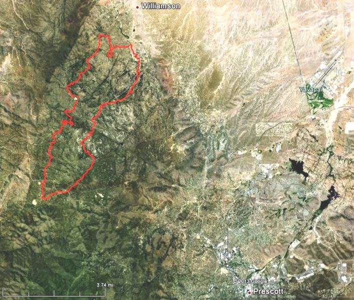
Map of Doce Fire at 11 p.m. MDT, June 18, 2013. (click to enlarge)
The map of the Doce Fire above shows the perimeter (in red) at 11 p.m. MDT Tuesday night.
More information is at Facebook and the very unreliableInciWeb.
****
(UPDATE at 9:15 a.m. MDT, June 19, 2013)
The Arizona Emergency Information Network (AZEIN) reports that the Doce Fire has burned 7,000 acres and is zero percent contained.
Below is evacuation information from the AZEIN. For the most current evacuation information, check their site.
Evacuated: Granite Basin Homes, Sundown Acres, Old Stage Acres, south half of Mint Creek, and American Ranch.
On notice for potential evacuation: neighborhoods in Williamson Valley
(There is an evacuation center at Yavapai College. Livestock should be taken to the Prescott Rodeo Grounds)
The AZEIN reported at 7:38 a.m. Wednesday:
The fire was active overnight on the northeast corner by the Williamson Valley Corridor and on the southwest corner by Granite Mountain Wilderness. No structures have been lost and no injuries have occurred.
One of the Predictive Services offices has issued another Fuels and Fire Behavior Advisory. The last one, issued June 10, was for California. This new one, dated June 16, is for portions of Arizona and New Mexico.
The advisory does not mention the “Southwest Monsoon,” an event that typically starts in early July and generally begins to draw the curtain on the fire season in Arizona, New Mexico, West Texas, southern Utah and southwestern Colorado.
Below is the full text of the advisory.
****
“Fuels and Fire Behavior Advisory
Arizona and New Mexico
June 16, 2013
Subject: Persistent multi-year drought across much of New Mexico and Arizona has dropped fuel moistures to critically low levels in the large dead and live foliar fuels. These critically low fuel moistures increase available fuel loading which contributes to and supports active crown fire in timber fuels when critical fire weather is present.
Discussion: The multi-year drought has reduced the fine fuel loading across most of the region so the focus for this advisory will be the timber fuels within the region.
Difference from normal conditions: Drought creates more available fuel in timber fuel types which will increase fire intensities, crown fire potential and difficulty of control for fire suppression resources. Short duration rain events provide only short term fuel moisture improvement in timber litter fuels (1, 10, and 100 hour dead fuels). Fuels rebound quickly to previous dryness levels. Short duration rain events provide no fuel moisture recovery in large dead and live foliar fuels.
Concerns to Firefighters and the Public:
Surface fire will quickly transition to crown fire and only requires low to moderate surface fire intensity to transition.
Active/running crown fire has produced long range spotting up to one mile under the influence of an unstable atmosphere.
Active fire behavior can extend well into night and early morning hours even with moderate RH recovery.
Thunderstorm activity will create a mosaic pattern of surface fuel moistures. Surface fire intensity and fire behavior may change abruptly when fires cross these boundaries of moist and dry surface fuels.
Mitigation Measures:
Local briefings need to be thorough and highlight specific fire environment conditions. These include but are not limited to local weather forecasts, Pocket Cards, ERC’s, live and dead fuel moistures, and special fuel conditions such as drought and insect mortality
Lookouts, both on the ground and in the air, can help identify the initiation and location of crown fire. They can also provide the location of resultant spot fires from active crown fire.
Firefighters should acknowledge that fire growth and fire behavior they encounter this year may exceed anything they have experienced before due to the drought factor. Normal strategies and tactics may need to be adjusted to account for the drought factor.
Area of Concern: Please reference the map posted on the National Fuel Advisory Page.
As wildfire season heats up the National Weather Service has cancelled their plans to force their employees to take four days off without pay before September 30. While a memo to all 12,000 NWS employees did not mention fire weather forecasts or Incident Meteorologists, it did refer to the tornadoes that plowed through Midwestern states last month. The Las Cruces Sun-News has more details.
Photos and videos of the 747 Supertanker, and a new CWN contract for the 20,000-gallon beast
The Denver Post has an article about the shortage of large air tankers in the United States and how that may have affected the early stages of the recent fires in Colorado. They also quote a very reliable source about the number of Unable to Fill (UTF) requests for air tankers.
Aspen Fire on Mount Lemmon, 10 years ago
It was 10 years ago today that the Aspen Fire ripped across the top of Mount Lemmon in Arizona, destroying nearly 340 homes and burning 84,000 acres.
Birds start fires in California and Nevada
A deluded conspiracy theorist might assume that terrorists have trained birds to fly into power lines and start fires, since over the last two days it happened in Chico, California and in Reno, Nevada. But in spite of the tin foil hat I’m wearing, I don’t think this quite meets the threshold for our Animal Arson series, since it is fairly common.
The news footage above indicates some of the people in the Phoenix area are pleased to have one of the DC-10 air tankers temporarily working out of the Phoenix-Mesa Gateway airport. Some Snake River Hotshots crewmembers detailed there out of Idaho are also interviewed in the piece.
After flying 10 missions on the Powerhouse Fire in southern California over two days, the air tanker flew two missions Tuesday on the Thompson Ridge fire which is spreading rapidly west of Los Alamos, New Mexico. Today they are back on the Thompson Ridge Fire again, reloading out of Roswell, New Mexico.
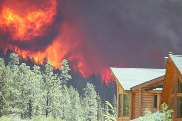
We ran across some photos of the Soldier Basin Fire that burned 10,775 acres in southern Arizona six miles north of the U.S./Mexico border near Nogales, Mexico. It started May 17 and by Saturday May 25 had been 75 percent contained and turned over to the Coronado National Forest’s Sierra Vista Ranger District.
All of the photos are from InciWeb and are uncredited.
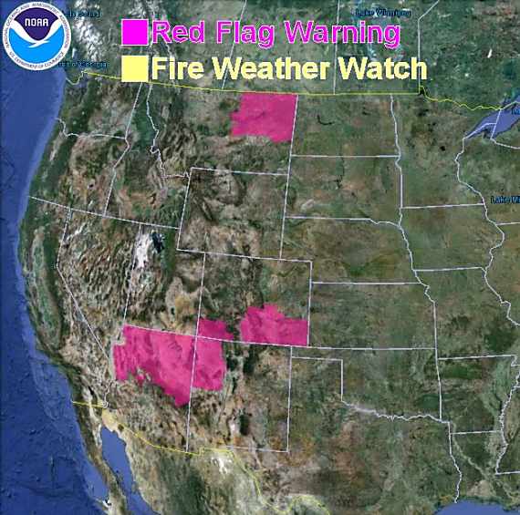
Red Flag Warnings for enhanced wildfire danger have been issued by the National Weather Service for areas in New Mexico, Arizona, Colorado, and Montana.
***
The Red Flag Warning map above was current as of 9:45 a.m. MT on Monday. Red Flag Warnings can change throughout the day as the National Weather Service offices around the country update and revise their forecasts. For the most current data, visit this NWS site.
The man who started the 17,446-acre Sunflower Fire 34 miles northeast of Phoenix has been sentenced to two years of probation, a $2,000 fine, and 200 hours of community service to be served with the Forest Service.
It cost taxpayers $4.4 million to suppress the fire. The U.S. Forest Service did not seek restitution.
On May 12, 2012, Craig Shiflet and four of his friends woke up in the Sycamore Creek area of the Tonto National Forest during a multiday campout-bachelor party for one member of the group. Mr. Shiflet loaded a Fiocchi incendiary round into his 12 gauge shotgun and fired at a soda box, apparently unconcerned about the warning on the box of shells which stated:
Shoots 100 feet of fire, setting everything in its path ablaze. Warning: Extreme FIRE HAZARD
(Another incendiary 12 gauge shotgun shell that has a similar effect is made by Dragon’s Breath.)
The vegetation began burning and the group tried unsuccessfully to stomp the fire out. Mr. Shiflet reported the fire to 911 and was instructed to leave the area by the dispatcher.
Federal agents began investigating the fire the day after its ignition. Witnesses provided probers with the license plate number of a GMC Yukon that was seen departing the Sunflower Fire. The vehicle was “occupied by five white males in their 20’s,” reported Lucas Woolf, a Forest Service agent.
After tracing the SUV to Pace, Woolf approached him on May 19 (the day of Reeder’s wedding) and said he wanted to talk about the Sunflower Fire. “I think that we may have had something to do with that,” Pace replied.
Woolf then interviewed Shiflet, who recalled firing an “orange shotgun round” at a soda box, expecting the round to “shoot out flame or act like a flare gun.” Shiflet provided Woolf with the “exact same type of shotgun shell that he fired” on May 12, triggering the massive blaze.
The photo below is an example of the use of an incendiary magnesium-based shotgun shell.
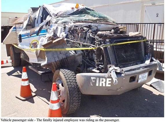
Engine rollover fatality that occurred June 9, 2012 on the Montezuma Fire in Arizona.
The recently released 2012 Incident Review Summary mentioned a report that we were not aware had been released — the engine rollover fatality that occurred June 9, 2012 on the Montezuma Fire in Arizona. Killed in the accident was the Bureau of Indian Affairs engine boss, Anthony Polk, 31, of Yuma, Arizona. Two crewmembers were injured, one very seriously.
The three-person crew was en route to their assignment that morning. The AD crewmember driving was in his first fire season and had started work five days before. He received a valid Federal Motor Vehicle Operator’s ID card on May 3, 2012 about a month before he started work.
Approximately 0745-0800 – The engines left the spike camp with Engine 1252 in the lead. Engine 6351 followed Engine 1252. Engine 6351 was being driven by Crewmember 2. Crewmember 1 occupied the middle seat, and the ENGB occupied the passenger side of the engine. The engines headed south on Indian Reservation Route 19. The engines drove up a moderate grade for the first couple of miles, crested the hill, and then started down a slight decline.
Approximately 0800 – The driver (Crewmember 2) stated that as they were driving and without prompting, the ENGB passed Crewmember 2 a bottle of water that had been on the dashboard on the passenger side where Crewmember 2 had previously been sitting. Crewmember 2 took the bottle and put it between his legs. The ENGB passed Crewmember 2 a second bottle of water and told Crewmember 2 to put the bottle behind his back.
As Crewmember 2 put the water bottle behind the back of his seat, he drifted off the right hand side of the road. He tried to steer the engine back onto the road, but overcorrected and went across both lanes of the road into the dirt on the other side. The engine flipped forward, landing with the weight on the hood and cab. The engine bounced, landed on its wheels and coasted across the highway (from east to west), coming to rest on the west side of the highway.
Findings, from the report:
The driver (Crewmember 2) was an AD Employee who was on his first off-unit fire assignment.
The driver (Crewmember 2) had no previous experience driving an engine.
The driver (Crewmember 2) was distracted, as water bottles were passed to him while he drove Engine 6351 on Indian Reservation Route 19.
No manual direction exists within the Bureau of Indian Affairs to ensure employees are qualified to drive Type 6 and larger engines.
Indian Reservation Route 19 is a relatively narrow road with no shoulder. The drop off from the paved surface to dirt is 4 to 6 inches. There is no “rumble strip” in place to alert the driver to the outside edge of the road surface.
Engine 6351 is a Chevrolet C-5500 engine platform (Model 52) rated as 19,500 GVW that has unique road handling characteristics that differ from the average sedan or pickup.
1. While this vehicle does not have a CDL requirement, the weight of the vehicle (19,500 GVW) contributes to its unique road handling characteristics.
2. The front axle width is approximately 15” wider than standard size vehicles. The axle width results in the vehicle encountering road surface irregularities differently than a vehicle with a narrower axle width.
One of our readers has spotted what he says are three helicopters and one air tanker that show up in satellite imagery visible on Google Earth. Brian found them on satellite photos taken June 12, 2011 which show the Wallow Fire in eastern Arizona actively burning.
Last month on Wildfire Today we had information about three aircraft that showed up on Google Earth satellite photos taken October 26, 2006 during the Esperanza fire in southern California. This link is a Google Earth KLM file that has place marks for all three aircraft. On that imagery, the air tankers were clearly visible. The four reported on the Wallow fire are not as clear, partly because three of them are helicopters, which of course are smaller than air tankers.
But check it out yourself. Here is the information provided by Brian. You can copy the lat/long and paste it into the search box on Google Earth.
AE350B helicopter: 33 32 40.27 -109 24 10.21
B212 helicopter: 33 32 46.02 -109 24 01.06
S64 helicopter: 33 32 55.26 -109 23 13.25
P2V air tanker: 33 32 44.35 -109 26 33.99
Even if the aircraft are not super clear, it is interesting seeing the photos of the active Wallow fire which started May 29, eventually becoming the largest fire in Arizona history, burning 538,040 acres, which includes 15,407 acres after it crossed the border into New Mexico.
Two men who are cousins have been ordered to pay $3.7 million for accidentally starting what became the largest fire in Arizona history. Last May David and Caleb Malboeuf left a campfire unattended in the eastern part of the state which escaped and became the Wallow Fire, eventually burning 538,040 acres, which includes 15,407 acres after it crossed the border into New Mexico.
The Malboeufs have asked the U.S. Magistrate to set the monthly payments for Caleb at $500 and $250 for David. At that rate it will take them about 4,900 years to pay it off.
The $3.7 million only includes claims that have been filed and approved by the court for actual damages that occurred, mostly on private land. The U.S. Forest Service agreed not to seek repayment for $79 million in suppression costs. However the agency and any of the victims could later initiate civil actions against the Malboeufs.