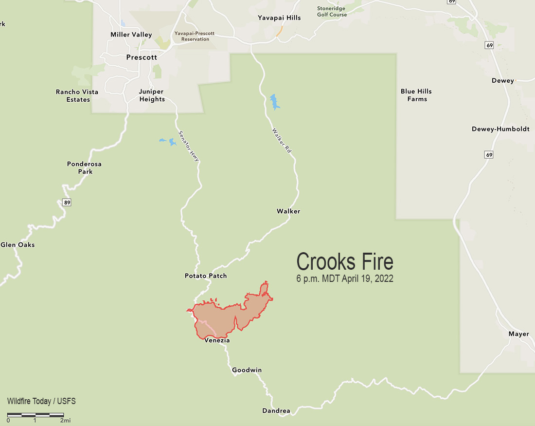
The Crooks Fire 8 miles south-southeast of Prescott, Arizona was 1,612 acres when it was mapped at 6 p.m. Tuesday. Most of the growth was toward the northeast as it burned south of Potato Patch and past Mt. Union as it approached Big Bug Mesa Road.
Red flag conditions in rugged terrain on Tuesday challenged firefighters and grounded aircraft through the day. Crews are looking for opportunities to construct indirect line hoping to keep the fire south of FSR 261 road and restrict its spread to the north.
A Type 1 Incident Management Team, California IMT 4, will assume command of the fire Wednesday at 6 p.m.
Resources assigned include 7 hand crews, 14 fire engines, and 5 helicopters for a total of 292 personnel.
Information about evacuations can be found at the Yavapai County Sheriff’s Department Facebook page.
1:16 p.m. MDT April 19, 2022
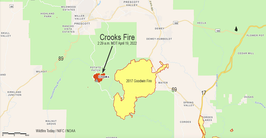
Map of the Crooks Fire showing heat detected by satellites at 2:39 a.m. MDT April 19, 2022.
A new fire, the Crooks Fire, broke out Monday eight miles south of Prescott, Arizona. Fire authorities said Tuesday the fire had burned 600 acres in the Prescott National Forest.
The fire is about two miles west of the Goodwin Fire that burned more than 28,000 acres in 2017.
The area is under a Red Flag Warning until 8 p.m. MDT Tuesday for 25 to 35 mph winds gusting out of the southwest at up to 50 mph with relative humidity around 10 percent.
Information from the Incident Management organization late Tuesday morning:
Ryan Barela’s Arizona Central West Zone Type 3 Incident Management will assume command of the Crooks Fire [Tuesday] at 6:00 PM. The fire remained active last night as crews worked through the night on structure protection and burning fuels along Forest Road (FR) 261 and along Senator Highway. Firefighters will focus today on keeping the fire south of FR 261 and east of Senator Highway. Fires in Prescott, AZ typically are driven by southwestern winds that push the fire to the northeast, therefore, we are prioritizing working on the northeastern part of the fire.
The Southwest Area Coordination Center said Tuesday afternoon that a Type 1 Incident Management Team from California, led by Incident Commander Gamboa, has been ordered.
(This article was corrected at 1:53 p.m. MDT Tuesday April 19 to correct conflation with the Crooks Peak Fire which is also in the Southwest Geographic Area.)
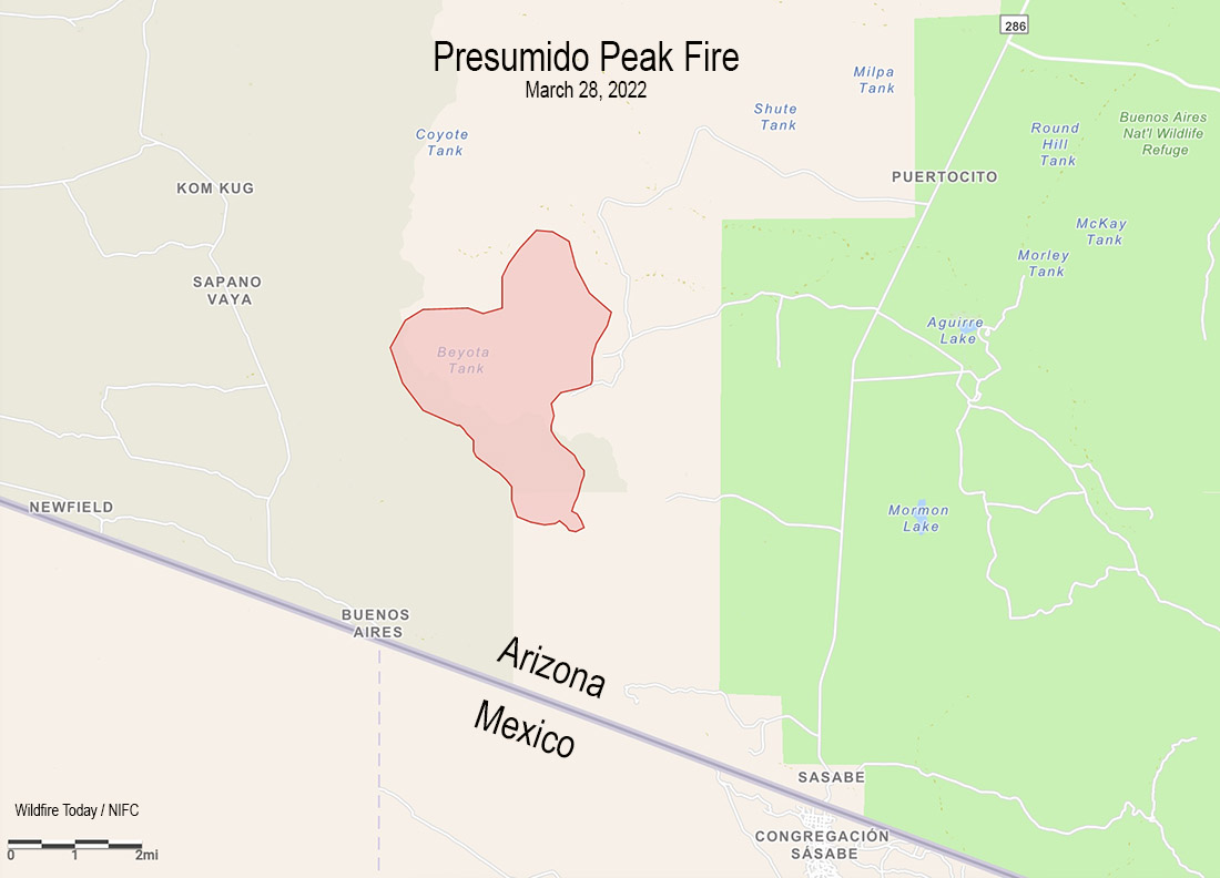
Vicinity map of the Presumido Peak Fire, March 28, 2022.
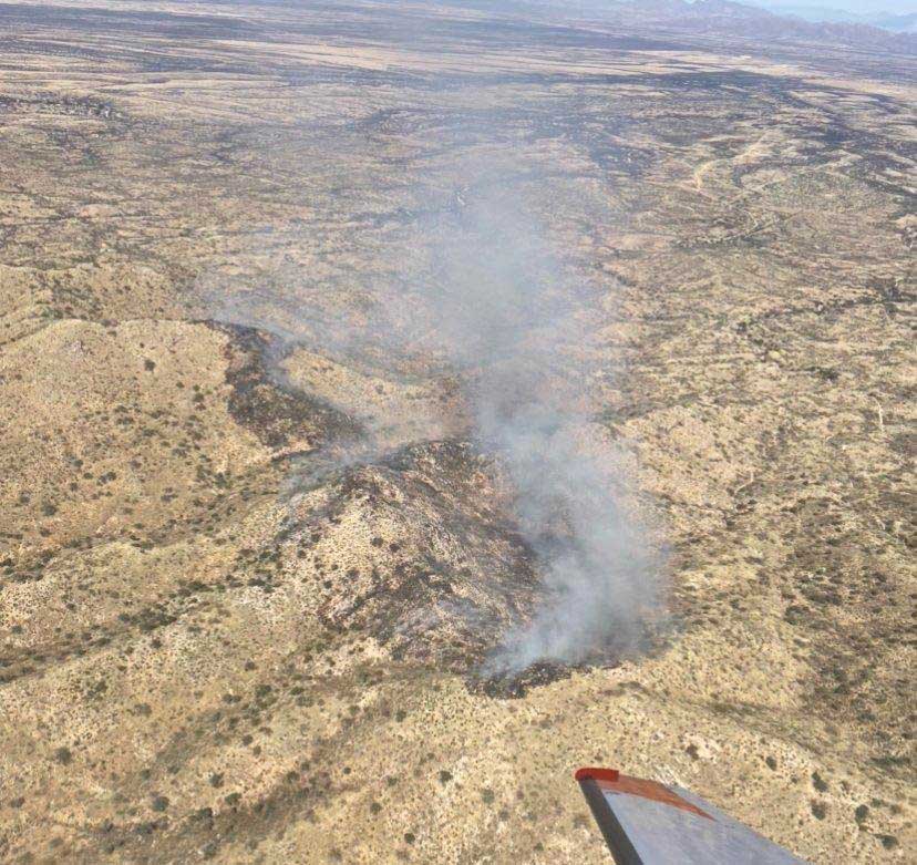
The Presumido Peak Fire in Southern Arizona had burned about 2,600 acres of grass, brush, oak, and juniper when it was mapped Monday. That number will be updated today after it made wind-driven runs Monday afternoon during Red Flag Warning conditions.
It is about 20 miles northwest of the border town Sasabe, two miles north of the US/Mexico border, on the edge of the Tohono O’odham Nation Reservation, and two miles west of the Buenos Aires National Wildlife Refuge.
Presumido Peak Fire map March 28, 2022. Incident Management Team.
On Monday the fire received light showers which decreased fire activity significantly. The forecast for Tuesday calls for 54 degrees and cloudy skies with a 70 percent chance of 0.10″ rain, with clouds clearing by 11 p.m. On Wednesday and Thursday firefighters should expect mostly clear skies, temperatures of 68 to 75, winds out of the west and then south at 15 mph, and relative humidity in the low 20s and high teens.
Monday night the management of the incident transitioned to a Type 3 organization with approximately 70 personnel assigned. Aircraft remain assigned and on standby, if needed. The human-caused blaze was discovered Saturday afternoon near Presumido Peak
Presumido Peak Fire, March 28, 2022. Incident Management Team.
Cameron Peak Fire smoke plume at Boyd Lake, InciWeb, Oct. 14, 2020.
In an effort to improve forest resilience and reduce the risk of catastrophic wildfires in the Interior West, three organizations are receiving a total of $20 million from the U.S. government.
The funds are part of the Infrastructure Investment and Jobs Act passed by Congress with bipartisan support and signed by President Joe Biden in 2021, which will go to enhancing key systems and processes to mitigate the impact of forest fires.
The award will be made to the Southwest Ecological Restoration Institutes (SWERI) which includes the Colorado Forest Restoration Institute (CFRI), Highlands University’s New Mexico Forest and Watershed Restoration Institute, and Northern Arizona University’s Ecological Restoration Institute. The SWERI were created through congressional legislation passed in 2004 which charged the three institutes with promoting adaptive management practices to restore the health of fire-adapted forest and woodland ecosystems of the Interior West.
The Colorado Forest Restoration Institute is housed in the Department of Forest and Rangeland Stewardship in CSU’s Warner College of Natural Resources.
The three institutes will work collaboratively on three key components with the funding, to:
Develop a national database of existing data on fuel treatments and wildfires,
Work with managers, planners, and policymakers to facilitate use and applications of the data, and,
Research outcomes of forest management and wildfires to learn what works.
“The work we’re charged with developing under the Infrastructure measure will create opportunities for land and fire managers, scientists and community stakeholders to co-produce actionable knowledge to lessen the harmful effects of wildfire events to people and the environment,” said Tony Cheng, director of the CFRI and professor in the Department of Forest and Rangeland Stewardship.
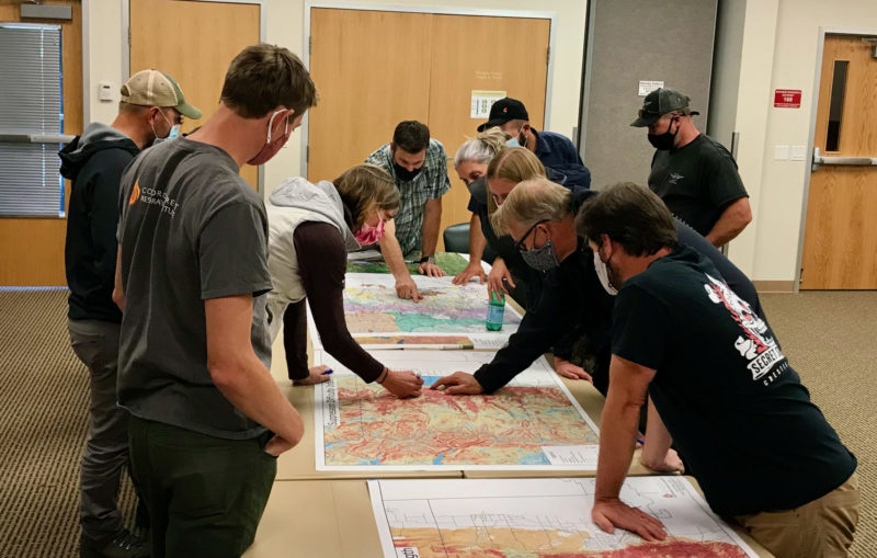
Land and fire managers and community stakeholders in Boulder County huddled around CFRI geospatial mapping products aided by CFRI’s science and outreach staff. Photo by Tony Cheng.
According to Cheng, the new funding aligns with the CSU land-grant mission and offers an opportunity to grow CFRI’s existing data management, application, and research efforts to be accessible for a wider audience.
The funding is prompted by climate change-driven increases in fire activity and fire season length, continued development in the wildland-urban interface, and interactions between fire and disturbances like pest and pathogen disturbance.
The CFRI recently completed a statewide database of forest vegetation management and wildfires for Colorado, complementing a similar effort for New Mexico and southern Colorado led by the New Mexico Forest and Watershed Restoration Institute. The data serve as a foundation for the decision support tools and collaborative processes that CFRI deploys around the state and throughout the Interior West. The national database will be developed using similar types of data across the country.
The data are only the starting point, said Brett Wolk, one of CFRI’s assistant directors. Making data meaningful for land and fire managers, scientists, policymakers, and community stakeholders working in their specific places is a critical function the institutes excel at and is called out in the Infrastructure provisions.
“Unless the data is situated within a social context where people can understand how it applies to their work, all the best data and science in the world won’t change decisions or outcomes on the ground,” said Wolk. “That’s why SWERI works to co-develop solutions with partners and empower decisions that are science informed but also locally relevant.”
A third component of the funding is researching outcomes of past treatments to improve future decisions. This will build on deep research expertise at the Arizona and Colorado institutes, exemplified by a recent CFRI co-led publication and accompanying podcast evaluating accomplishments of the Forest to Faucets partnership aimed at protecting Denver’s water supply from devastating wildfires.
The challenge, Wolk said, is applying the collective institutes’ knowledge and expertise across the entire U.S. At the same time, there is an opportunity for other states to benefit from the collective knowledge across the institutes.
“It’s a massive opportunity to help fast-track implementation of what’s working in forest and fire management. But research also shows big gaps in who has access to and contributes knowledge towards these forestry data and decision-making processes. If we can increase the application of science, while making incremental change to expand equity of ideas and resources among wider audiences, those will be our measures of success.”
The incident occurred at about noon during initial attack efforts on the Cedar Basin Fire, which is 14 miles east of Wikieup in northwestern Arizona.
Pilot Matthew Miller, 48, and Air Tactical Group Supervisor Jeff Piechura, 62, were on board a Beechcraft King Air C-90 aircraft conducting visual reconnaissance and aviation command and control over the fire. Mr. Miller was a fire pilot with Falcon Executive Aviation, Inc. contracted by the U.S. Forest Service. Mr. Piechura was an employee with the Coronado National Forest. Their remains have been recovered from the accident site.
Often eyewitness accounts are wrong.
But, the Arizona Republic interviewed a woman who saw the aircraft from her home coming down at a “steep angle” and then “slam into the ground.” An hour later she and her husband drove to an area near the crash. They said Bureau of Land Management employees told them they they witnessed a wing fall off the plane in the air before it crashed.
We are aware of four other wildland fire related aircraft crashes in North America this year in a 46-day period, for a total of 7 fatalities:
A helicopter went into Lake Shastina July 7 while working on the Lava Fire in Northern California. The pilot swam away.
Four were killed in the May 25 crash of a helicopter at Leesburg, Florida.
In 2020 during a 49-day period that began July 7 there were six crashes of firefighting aircraft — three helicopters and three air tankers. In addition, three members of the crew of a C-130 from the U.S. died when their air tanker crashed January 23, 2020 while fighting a bushfire in New South Wales, Australia.
The article was edited to show that there were no reported serious injuries in the June 15 helicopter crash.
3-D map of the Tiger Fire at 9:30 p.m. MDT July 2, 2021, looking northwest.
The Tiger Fire three miles northwest of Black Canyon City, Arizona was very active Friday night. In the six hours after it was mapped at 9:30 p.m. it ran north for almost two miles, according to data collected by a satellite at 4:04 a.m. Saturday (see map above). It was burning aggressively in the footprint of the 4,900-acre Rattlesnake Fire of 2015.
Early Saturday morning the Tiger Fire was about 2 miles west of Interstate 17 and 5 miles southeast of Crown King. At 9:30 p.m. Friday it had burned 5,567 acres, but the later additional spread could have added more than 1,000 acres.
Map of the Tiger Fire. The white line was the perimeter at 9:30 p.m. MDT July 2, 2021. The red areas represent heat detected by a satellite at 4:06 a.m. MDT July 3, 2021. North is at the top.
The lightning-caused fire was reported at 2 p.m. on June 30.
Resources assigned to the fire Friday evening June 2, included 2 hand crews, no fire engines, and 2 helicopters for a total of 63 personnel.
Firefighters are scouting the west side to plan locations for potential fire lines to control the growth. On the east side they are identifying old mines and other hazards and looking at values of risk for future structure protection.
Due to severe drought the vegetation, or fuels, are dry or dead which can accelerate the spread of the fire.
In a Saturday morning update the Incident Management Team said, “Access into the Castle Creek Wilderness is limited by the steep terrain making it unsafe for firefighters to fight the fire directly at the edge. The incident management team is being strategic on the placement of firefighting resources to ensure safe ingress/egress. Protection of life is the highest priority.”
Tiger Fire. Posted on Inciweb around July 2, 2021.
Firefighters have made progress on the 77,102-acre Rafael Fire in Arizona. In a video briefing Monday morning Operations Section Chief Rocky Gilbert said due to the firing operations completed on the northeast side there is no longer a threat to the city of Flagstaff.
Their map shows that at least half of the perimeter is held fire line (the black line), and officially the Incident Management Team reports that the fire is 48 percent contained. There is still much work to be done on the northwest and south sides. The map below of heat detected by a satellite Sunday night shows quite a bit on the northwest side, but almost none on the southern perimeter.
The red areas on the map represent heat detected by satellites on the Rafael Fire at 1:45 a.m. MDT June 28, 2021. The red line was the perimeter at 1:45 a.m. June 28.
The Rafael Fire is:
6 miles south of Interstate 40
13 miles southwest of Flagstaff
7 miles west of Highway 89A, and
10 miles northwest of Sedona
Firefighters on the Rafael Fire conduct a burnout June 27, 2021. Photo by Michelle Herrin.