It is extremely dry in much of California, southern Idaho, and Nevada.

News and opinion about wildland fire

Investigators used GPS tracking devices to gather evidence about a former firefighter who is accused of setting several wildfires in California, including the Clover Fire that killed one resident, burned 8,073 acres, and destroyed 60 homes.
Zane Wallace has been charged with over 200 arson-related counts, including 60 for arson to occupied structures. The fires occurred in September and October of 2013 in Shasta County.
According to information uncovered by the Redding Searchlight, investigators interviewed Mr. Wallace the day after the Clover Fire started, and later placed the tracking devices on two of his vehicles, which were later recorded at the location of some of the fires that started after the GPS devices were in place.
The U.S. Forest Service confirmed that Mr. Peterson was a former employee on the Mendocino National Forest. He worked as a firefighter (Forestry Technician) and fire engine operator from May 15, 2005 until October 22, 2012.
Thanks and a hat tip go out to Dick
January wildfires in northern California
Even though a major winter storm has caused 4,121 flights to be cancelled and another 11,284 to be delayed today across the United States, northern California has experienced four medium to large fires already this year.
On Sunday the U.S. Forest Service activated one large air tanker, Minden’s Tanker 48. CAL FIRE has been using multiple helicopters and air tankers on these fires.
Timeline released for Colorado’s Black Forest Fire
The El Paso County Sheriff’s Office has released their own timeline for the early stages of the Black Forest Fire near Colorado Springs that burned 486 homes beginning on June 11, 2013. Below is an excerpt from an article at The Denver Channel:
The El Paso County Sheriff’s Office has released its own timeline of events for the Black Forest Fire which indicates the fire was first reported nearly two hours earlier than the Black Forest Fire/Rescue District reported.
In a Dec. 10 news release, the Black Forest Fire/Rescue District said the fire was first located at 1:45 p.m. on June 11.
However, the sheriff’s office timeline released Monday shows callers to 911 started reporting a haze and the smell of smoke at 11:54 a.m.
At 1:40 p.m., emergency radio traffic is heard saying, “you might start getting more call of localized smoke,” but they blamed it on the Royal Gorge wildfire burning in Canon City, saying”looks like there is a fire in Canon City.”
However, in the same report, the person says, “pretty good column on Hodgen Rd.,” which is near the Black Forest area.
County Sheriff Terry Maketa has been EXTREMELY critical of Bob Harvey, the Fire Chief responsible for the first two hours of the initial attack of the fire.
Prescribed fire workshops in Nebraska
Prescribed fire workshops will be held in eight locations across Nebraska between January 21 and March 19, 2014. Hosted by Pheasants Forever, Nebraska Game and Parks, and several other organizations, the one-day sessions are broken down into basic and advanced classes.
The workshops for landowners will discuss benefits of prescribed fire and how to safely conduct a project. Topics covered include equipment and safety, environmental factors, techniques for conducting prescribed fires, briefings, items to consider when writing a burn plan, possible funding sources, and how to factor in weather conditions. There will also be an exercise on how to write a burn plan. The registration fee of $10 includes lunch and training materials.
In order to conduct a prescribed fire in Nebraska, a landowner needs to have a burn plan and a permit from the local fire department.
More information, including dates and locations.
Recent articles at Fire Aviation
Here is what you may have missed at Fire Aviation:
Drought Monitor
The Drought Monitor shows that most of California, Nevada, and southern Idaho are in either a severe or extreme drought. This could be an interesting winter fire season if it continues.
Arizona State Forestry Division wants to almost double budget
The state organization responsible for managing the Yarnell Hill Fire is requesting a budget for the Arizona State Forestry Division that is nearly double what they received in the fiscal year that ends June 30. According to an article at Azcentral, State Forester Scott Hunt wants to add $6.2 million to this year’s budget of $7.3 million. The additional funds would be used to hire 15 additional staffers, replace firefighting and communications equipment, and allocate $2 million to remove hazardous vegetation on state and private lands. The budget request was filed in October, after 19 firefighters died on the Yarnell Hill Fire but before the state Division of Occupational Safety and Health issued their report on the fire and recommended a $550,000 fine be imposed on the Arizona State Forestry Division as a result of the fatalities on the fire.
Retired smokejumper interviewed on Montana Public Radio
Retired smokejumper Wayne Williams is featured in an interview on Montana Public Radio. In the 11-minute recording Mr. Williams speaks eloquently from his decades of experience. It is refreshing to hear someone interviewed about wildland fire in the media who knows the subject matter. The audio is HERE, and a short article with his photo is HERE.
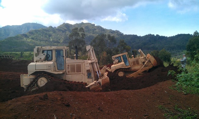
Army attempts to prevent wildfires at Schofield Barracks

In October and November two wildfires started at a range used for controlled detonations to dispose of unexploded ordnance at Schofield Barracks west of Honolulu, Hawaii. The fire that started October 15 burned more than 250 acres. It was fought for five days, then two days later rekindled and was finally extinguished October 28. Another fire in November burned about 30 acres.
In order to reduce the chances of vegetation fires igniting from the explosions, soldiers are using dozers to increase the height of the dirt berm surrounding the range from 7 feet to 22 feet. During the project, which was conducted 24 hours a day between December 9 and 13, they moved 5,800 cubic yards of dirt.
Wildfire Tweets
Below are a couple of messages on Twitter that had photos of fires — at Valparaiso, Chile and Lake Tahoe, California (which may be a prescribed fire).
MT @JoviEspinoza86 2 January: #Wildfire continues in the hills of #Valparaiso, #Chile. #incendioforestal #brushfire pic.twitter.com/yObLzZ3M3y
— The Disaster Channel (@DisasterChannL) January 3, 2014
Happy Friday from #LakeTahoe, CA! #Seattle #RealEstate #Photography #wildfire #tornado http://t.co/VvTYDhYz82 pic.twitter.com/K0u4cV2mJ3
— TCPetersonPhoto (@TCPetersonPhoto) January 3, 2014
Thanks and a hat tip go out to Dick and Chris
Red Flag Warnings for elevated wildfire danger have been issued by the National Weather Service for some areas in California through 4 p.m. PST Monday for very low humidities in the southern Sierra Nevada and the Tehachapi Mountains. This includes the Kern County Mountains, the Sierra Nevada from Yosemite National Park to Kings Canyon National Park, and the Tulare County Mountains.
Winds are expected to be northeast at 5 to 15 mph with gusts to 20, along with relative humidities of 10 percent or less.
The Red Flag Warning map was current as of 10:41 a.m. MDT on Monday. Red Flag Warnings can change throughout the day as the National Weather Service offices around the country update and revise their forecasts. For the most current data, visit this NWS site.
(Originally published at 9:29 a.m. PST, December 28, 2013; updated at 10 a.m. PST December 29, 2013)
 The National Weather Service has issued Red Flag Warnings for elevated wildfire danger in some areas of California Saturday night through Sunday. The areas affected include the greater Bay area, the southern Sierras, and in southern California the counties of Los Angeles and Ventura. Santa Ana winds are expected to gust in the 50 to 60 mph range across the mountains with occasional gusts to 70 mph. In the coastal and valley areas 40 to 55 mph winds are expected. Humidities will likely lower into the teens and single digits on Sunday. The winds will diminish Sunday night but the warm and dry conditions will persist into Monday.
AT 9:53 PST on Sunday morning the weather station at Chilao north of Los Angeles recorded 8 percent relative humidity, sustained winds of 42 mph, and wind gusts to 67 mph.