Lightning ignites multiple fires in Trinity County, California and prompts evacuations

Monument Fire and McFarland Fire are two of the largest

1:51 p.m. PDT August 2, 2021
Map McFarland Fire
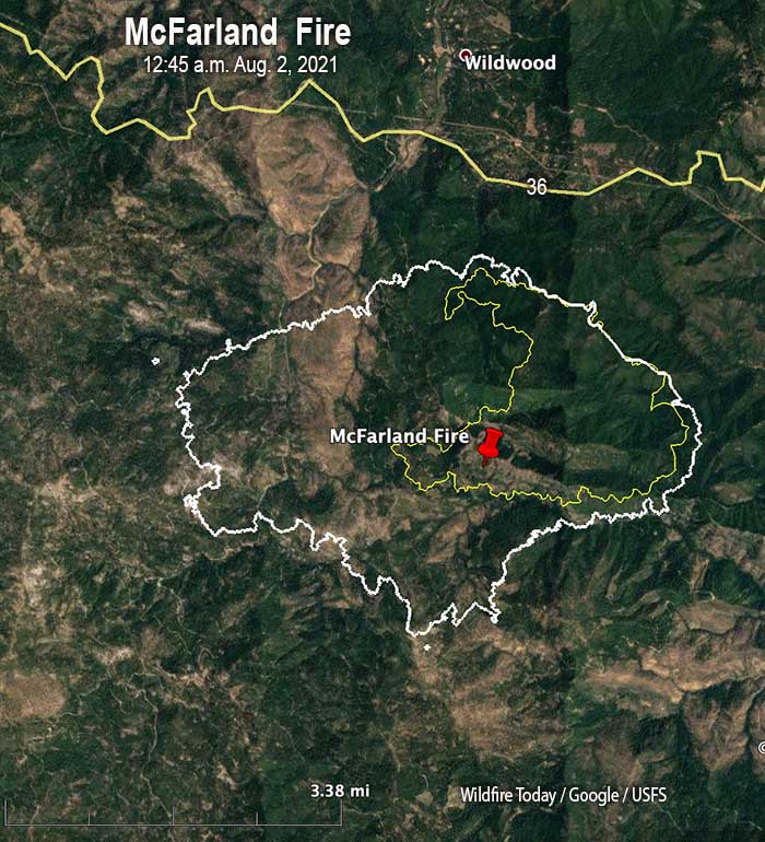
Map of the McFarland Fire. The white line was the perimeter at 12:45 a.m. PDT Aug 2, 2021. The yellow line was the perimeter approximately 24 hours earlier. (scroll down to see a map with a wider view)

The McFarland Fire South of Wildwood, California burned intensely Sunday afternoon, spreading two miles to the west and a mile south. A mapping flight at 12:45 a.m. Monday showed it had consumed about 5,000 additional acres in the previous 24 hours to bring the total to approximately 7,400 acres. It moved a little closer to Highway 36 and during the flight was about three-quarters of a mile south of the highway.

The Shasta-Trinity National Forest reported on their Facebook page Monday at noon that overnight “the fire spotted three miles to the west around Hell To Find Lake.” We confirmed with FS, “A spot fire occurred three miles west of the main fire?” and they said yes.

On Monday the fire became established in the upper headwaters of Beegum Canyon, with tree torching, spotting and rollout in the steep terrain. Fixed wing air tankers made retardant drops to slow fire spread and allow ground resources the opportunity to construct containment hand lines in some areas along the fire perimeter.

McFarland Fire
McFarland Fire. Looking south from the Hayfork2 camera at 9:47 a.m. PDT Aug 2, 2021.

The McFarland Fire is about a mile north of a large fire from 2020, the Hopkins Fire which merged with several other fires to become the Elkhorn Fire. It is a few miles south of the 2008 Telephone Fire and the 2015 Sheill Fire. Two other fires from 2008 are several miles to the east, the Gulch and Noble Fires.

A Type 2 Incident Management Team was expected assume command Sunday night.

Map Monument Fire
Map of the Monument Fire. The white line was the perimeter at 12:10 a.m. PDT Aug. 2, 2021. The yellow line was the perimeter approximately 24 hours earlier. (scroll down to see a map with a wider view)

The Monument Fire two miles west of Big Bar, California was very active Sunday afternoon spreading about a mile to the north, coming close to Highway 299, but it slowed overnight in calmer winds. A mapping flight at 12:10 a.m. Monday determined it had burned 3,114 acres, an increase of about 2,000 acres in approximately 24 hours.

Crews are focusing on building direct containment lines and assessing and preparing structures in Del Loma, Big Bar, and Pattison Ranch.

Evacuation warnings are in effect for these communities. More information can be found at the Trinity County Sheriff’s Office Facebook page.

Highway 299 has been closed intermittently due to active fire behavior and rolling material.

A Type 1 National Incident Management Organization (NIMO) Incident Management Team has been ordered for the incident.

So far, the fire is burning entirely in the footprint of the 2008 Cedar Fire, part of the Iron Complex of fires, and firefighters are opening some of the dozer lines used 13 years ago. Nine firefighters and pilots were killed when a Sikorsky S-61N helicopter crashed while working on the Iron 44 Fire that was part of that complex.

Below is a map showing the fires that have occurred in the area of these two fires, McFarland and Monument, since 2000.

Monument & McFarland Fire history
Monument & McFarland Fires, history of fires in the area since 2000. NIFC.

7:33 p.m. PDT August 1, 2021

Map of the Monument & McFarland Fires
Map of the Monument & McFarland Fires at approximately 3 a.m. PDT Aug 1, 2021.

Lightning on July 29 started more than a half-dozen fires in Northern California’s Trinity County. As of Sunday afternoon two have burned more than 1,000 acres each and prompted evacuations. According to satellite photos and heat data from satellites Sunday afternoon both were very active. Very large smoke plumes were photographed moving north-northwest toward southwest Oregon,

Sunday morning the McFarland Fire, discovered July 31, was south of Cold Creek Road (Highway 36) a mile or two south of Wildwood, California. It is 7 air miles west of Platina, 15 miles southeast of Hayfork, and 38 miles southwest of Redding. At about 6 p.m. the Trinity County Sheriff’s office issued an evacuation order “for the town of Wildwood, CA. Evacuation areas are SR 36 @ Wildwood Road, north on Wildwood Road for 10 miles.”

At 9 a.m. Sunday the Shasta-Trinity National Forest said the McFarland Fire had burned 2,100 acres, but judging from the satellite imagery at 6 p.m. local time it likely has grown substantially since then. A Type 2 Incident Management Team will assume command Sunday night.

Satellite photo Monument & McFarland Fires
Satellite photo of smoke from the Monument & McFarland Fires at 6:31 p.m. PDT Aug 1, 2021. NASA.

The Monument Fire is about 28 air miles northwest of the McFarland Fire. A mapping flight very early Sunday morning showed it was about a half mile south of Highway 299, which is now closed, and about two miles west of Big Bar. The Forest service said the fire’s movement Saturday was primarily to the east. By 2 p.m. Sunday satellite data indicated it had spread north closer to the highway.

Sunday morning the Shasta-Trinity National Forest said the Monument Fire had burned 1,000 acres, but like the McFarland Fire, it has probably also grown substantially since then.

The Trinity County Sheriff’s Office issued evacuation warnings for structures on both sides of the Trinity River near Del Loma along Highway 299 at approximately 10 p.m. Saturday night. A Type 1 National Incident Management Organization (NIMO) Incident Management Team has been ordered for the incident.

McFarland Fire
McFarland Fire, looking south from the Hayfork2 camera at 7:29 p.m. Aug 1, 2021

Video of lightning -struck tree burning is impressive

This video of a lightning-struck tree burning is mesmerizing. Michael Bogan of the University of Arizona filmed it July 31 in Southern California near Big Bear Lake. The US Forest Service responded, Mr. Bogan said, and suppressed the fire.

Be sure your sound is turned on while viewing it.

Washington Governor, “Everything we need to fight forest fires is in dire need across the Western United States”

Multiple governors asked President Biden for aerial assets, firefighters, help in obtaining aviation fuel, and aggressive initial attack

Air resources on the Cedar Creek Fire
Aviation resources on the Cedar Creek Fire in Washington, July 29, 2021. InciWeb.

Friday President Biden hosted his second virtual meeting to discuss wildfire preparedness. This session was with the Governors of three western states, Montana, Washington, and California. The earlier meeting on the topic was June 22, 2021.

The Governors told Mr. Biden that their states need more aviation resources, they need help with obtaining aviation fuel, they need more boots on the ground, and they encourage aggressive initial attack.

“Everything we need to fight forest fires is in dire need across the Western United States,” said Governor Jay Inslee of Washington.

These requests, coming from multiple states in late July with the meat of the fire season still possibly on the horizon, are astonishing.

The President began the meeting with a few remarks before asking the three Governors what the Federal government could do to help.

“Our resources are already being stretched to keep up,” Mr. Biden said.  “We need more help, particularly when we also factor in the additional nationwide challenges of pandemic-related supply chain disruptions and our ongoing efforts to fight COVID. We’ve had a few COVID clusters at our fire camps, which further limits resources.  It’s just one more reason why it’s so darn important that everyone get vaccinated, I might add. Sadly, we’ve also lost two brave firefighters in the last month in a plane crash in Arizona, and five were seriously injured last week battling the Devil’s Creek fire in Montana. It’s — to state the obvious, and you governors know it better than anybody — it is really, really dangerous work, and it takes incredible bravery to do it.  And these heroes deserve to be paid — and paid well — for their work.  That’s why, last month, I was able to announce — and it’s not paying that well, in my view, to be honest with you — immediate action to make all federal firefighters making at least $15 an hour.  I think they deserve more than that. We’re also working with Congress to make sure that our firefighters are paid better permanently.  Permanently.”

Governor Greg Gianforte of Montana was called on first. He spoke briefly, saying that aggressive initial attack was important. “Without that commitment,”Governor Gianforte said,  “we would have had many more large scale fires. And we ask that our federal partners join us in applying this operating principle. Whether it’s a fire that starts on private, state, or federal land — fires are easier to manage when they’re smaller.”

Governor Gianforte then went on to talk about active forest management.

Below are quotes from the other two Governors.

Governor Jay Inslee, Washington

My biggest concern might surprise you because all of the governors share these immediate concerns.  We have a huge need for additional aerial assets, additional dozer bosses so we can get our dozers into fire lines.  We need new tra- — more trained people.  We do have an emerging concern about our fuel supply for our aerial assets.  Everything we need to fight forest fires is in dire need across the Western United States, not just in Washington State.  We’ve had a thousand fires.  It’s burned four times more at this time of year than normal.  We’ve had two and a half times more acreage burn in the last decade than the previous.

Governor Gavin Newsom, California

Look, I just want to briefly — because there’s so many of us — a quick update.  We’re blowing past every record, and not in a good way.  We’re at over 5,700 fires year-to-date.  We suppressed 59 just yesterday with some initial attacks.  Over half a million acres already burned in California. To put in perspective — a record-breaking year.  Last year, we were at 130,000 acres burned.  We’re at 504,000 as I speak to you today.

Here’s the answer to your question.  And forgive me for being so pointed again, respecting your time, but I want to be a little bit more specific. Jay referenced it obliquely.  Please pay attention to this fuels issue.  We had to get our National Guard to get some emergency fuel supplies for our aerial fleet a week ago.  This is a major issue, and it’s not just impacting our aerial suppression strategies on the West Coast.  It’s increasingly, as you may know, impacting commercial aviation.  It is a major issue.

Number two, we just simply need more boots on the ground.  We can’t do without you.  We’ve got 7,400 people — 7,400 already.  We’re not in fire season.  Fire season in California is late September, October, into November.  We’re in July.  We already have 7,400 personnel actively working to suppress fires. Last year, the federal government asked us for over 5,000 mutual aid support that we could not provide.  That gives you a sense of what the federal government wanted from California last year to send to other states.  That should give you a sense of how far behind we are with federal support.

We have four DC-10s, Mr. President.  Four.  Now, DC-10s aren’t the answer to every problem.  They don’t fly over 35 knots.  They have restrictions; there are legendary restrictions.  But the reality is there is four for the country, and we’re competing.  They’re all contracted.  We compete with you.  We compete with other states.  We don’t even have access right now to DC-10s. We lost that 747 — that iconic 747 — that now has been converted to a cargo plane.  You’ve seen that in Australia, not just across the West Coast.  That’s now been grounded by a private contractor.

We are the largest civil aviation fleet for firefighting in the world — California.  We do not come close to having the tools in the air that we need.  We need your support to su- — to dramatically increase the aerial support, in addition to boots on the ground.

But here’s the final thing, and it’s the elephant in the room.  I was with Governor Sisolak two days ago in his state of Nevada.  The reason why is we had a fire that was on federal property.  Fifty-seven percent of the forest property in California is federal, just three percent under California jurisdiction.  Three percent.  Fifty-seven percent under U.S. Forest Service.  U.S. Forest Service is spectacular.  We have deep admiration and respect, but there’s a culture that, too often, is, “Wait and see.”  We can’t afford that any longer.  This was a federal fire.  They waited.  And what we saw is the fire took off because we didn’t put enough initial assets.

Greg was making an oblique point here.  I want to be a little bit more explicit: We need your help to change the culture, in terms of the suppression strategies, in this climate, literally and figuratively, to be more aggressive on these federal fires. That fire bled into Nevada and, obviously, impacted not just our two states, but deeply impacted the redundancy of this concern that comes out every year around jurisdictions and incident command and the imperative that we’re all on the same page, in terms of those initial attack strategies.

Firefighters are utilizing tactical firing operations to slow spread of the Dixie Fire

The blaze south of Chester, California has burned more than 212,000 acres

Dixie Fire map,
Dixie Fire map. The white line was the perimeter at 11 p.m. PDT July 27, 2021. The green line was the perimeter about 48 hours earlier. The red dots represent heat detected by a satellite at 2:49 a.m. PDT July 28, 2021.

A mapping flight Tuesday night found that the Dixie Fire south of Chester, California grew by about 14,000 acres in 24 hours, to bring the total up to 212,799 acres. Much of the expansion was on the northwest side where crews are preparing firelines and conducting burning operations when the weather cooperates. There was also movement on the east side north of Bucks Lake where difficult, rocky terrain is a challenge for firefighters, and near Twain and Crescent Mills. Another burning operation has been ongoing on the Mt. Hough road northeast of Quincy.

To see all articles on Wildfire Today about the Dixie Fire, including the most recent, click HERE.

The Incident Management Team reports that 34 structures have been destroyed, in addition to another 19 described as minor.

Resources assigned to the fire Tuesday evening included 82 crews, 319 engines, and 34 helicopters, for a total of 5,301 personnel.

The thick layer of smoke over the southern half of the fire lifted Tuesday morning and early afternoon, but smoke settled into the lower elevations in the evening. Air operations were also active Tuesday, including on the south perimeter near Bucks Lake. Trace amounts of rain fell in localized spots of the fire which slowed the progression of the fire and limited firefighters’ tactical firing operations.

Channel 7 KRCR has an interesting story about how firefighters have been applying large amounts of water about two miles northeast of the fire in the community of Taylorsville, in an effort to keep things wet in case of an ember shower.

Man fires several shots at Firehawk helicopter in Southern California

The person was found and arrested after an hours-long search

Joshua James Chimarusti
Joshua James Chimarusti. Photo by Ventura County Sheriff’s Department.

On Thursday morning, July 22, 2021, Joshua Chimarusti was arrested after he fired several rounds from a handgun at a Ventura County Firehawk helicopter in Southern California.

On July 21, 2021 at approximately 9:15 PM, the crew of Ventura County Firehawk Copter 4 was conducting nighttime training operations in Lake Casitas when they became aware of gunfire directed at them. The pilot of Copter 4 took evasive action and identified a suspect vehicle leaving the area at a high rate of speed.  Copter 4 followed the suspect vehicle into Oak View where it came to a stop in the 200 block of Olive Street. The suspect, who was later identified as Joshua Chimarusti, exited the vehicle, and fired additional shots from a handgun at Copter 4. Mr. Chimarusti ran away to avoid being arrested.

An extensive search of the area was conducted by by patrol Deputies, various investigative units, K9, UAV, a small SWAT contingent, and Ventura County Copter 3. Mr. Chimarusti was ultimately located and taken into custody in the early morning hours of July 22, 2021. The handgun he used during both shootings was also located and seized as evidence. Ventura County Copter 4 did not sustain any damage from the incident.

Mr. Chimarusti was arrested and booked for attempted murder, assault with a firearm upon a peace officer or fire fighter, shooting at an occupied aircraft, discharge of a firearm with gross negligence, prohibited person in possession of a firearm, and carrying a loaded unregistered firearm. He had a court appearance scheduled for arraignment in Ventura County Superior Court on July 26.

Ventura County FireHawk
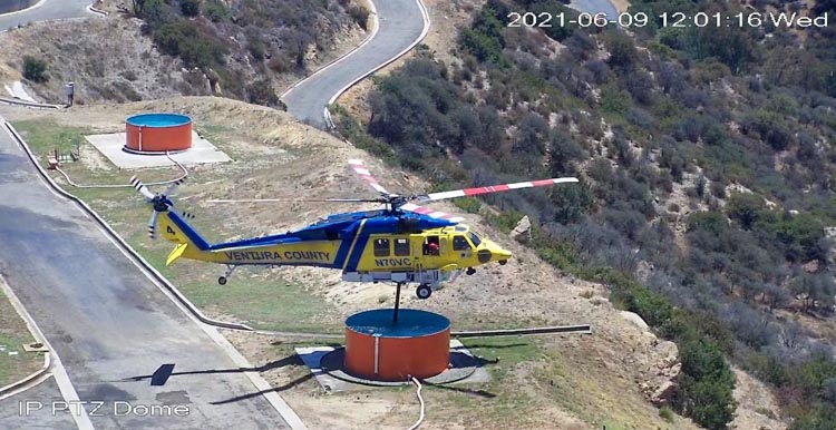
File photo of Ventura County FireHawk Copter 4 testing new tanks at 69Bravo, June 9, 2021 near Topanga, California . Photo from 69Bravo cameras.

Ventura County purchased three military HH-60L Blackhawk helicopters and is converting them into FIREHAWKS that will be used for fighting wildland fires, personnel transport, search and rescue, law enforcement, and medical evacuation.

The County has a joint Fire Department and Sheriff’s Department Aviation Unit. In addition to the FIREHAWKS, they have one Bell 206 Jet Ranger, one Bell 212 HP, one Bell 205B, and two UH-1A Hueys.

Tamarack Fire lifts evacuation orders for nearly 2,000 residents

The fire 15 miles southeast of South Lake Tahoe has burned more than 67,000 acres in California and Nevada

10:32 a.m. PDT July 26, 2021

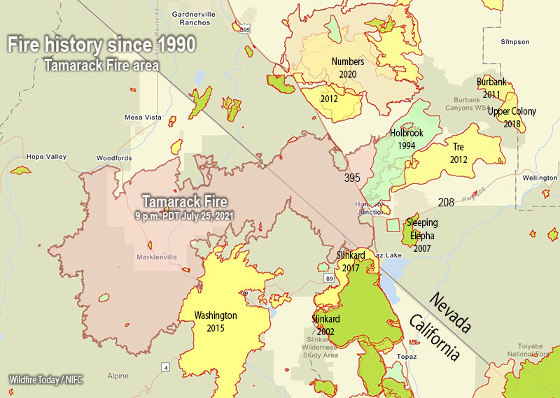
Fire history, Tamarack Fire
Map showing the perimeter of the Tamarack Fire July 25, and the history of fires in the area since 1990.

Law enforcement authorities in Alpine and Douglas Counties ended evacuations Sunday in 15 communities near the Tamarack Fire 15 miles southeast of South Lake Tahoe, enabling nearly 2,000 residents to return to their homes. The number of people still under evacuation orders is now approximately 300. A map is available showing the current status of evacuations.

The fire has burned 67,764 acres.

Monday morning authorities reopened Highway 395 on the east side of the fire and Highway 88 on the west.

The fire history map above shows that the Tamarack Fire burned into the footprints of multiple fires from previous years, including Washington (2015), Slinkard (2017), Holbrook (1994), and possibly Tre (2012). Not shown on the map is the East Fork Fire that burned in the notch in the perimeter east of Woodfords a few weeks before the Tamarack Fire. Depending on the vegetation type and the recency of the earlier burn, a new fire will usually slow down when it encounters a fire footprint, exhibiting less resistance to control. If it is not too windy, a combination of aerial and ground-based firefighters can often be effective in slowing or stopping the spread in those areas.

Tamarack fire
Tamarack fire July 25, 2021. The brown areas represent evacuation zones. Map produced by the fire Incident Management Team. Accessed at 9:30 a.m. PDT July 26, 2021.

The National Situation Report indicates that 15 structures have burned. A map is available showing the location of destroyed and damaged structures.

Hand crews were able to complete containment of the northern edge and several other critical locations on the fire Sunday. Monday’s priorities include finishing containment on the northeast corner and securing more of the southern edge.

Thunderstorms are in the forecast Monday afternoon, and there is a chance for rain into the evening.

Southeast side of Tamarack Fire
Southeast side of Tamarack Fire July 25, 2021. InciWeb.