Should homes be banned in fire-prone areas?

Jurisdictions need to develop standards for structures, the home ignition zone, and community infrastructure

before after camp fire paradise california homes burned
A neighborhood on Debbie Lane in Paradise, California, before and after the Camp Fire that started November 8, 2018. The homes were 14 to 18 feet apart.

In the weeks after 86 people were killed and over 14,000 homes and businesses were destroyed in the Camp Fire at Paradise, California three influential individuals and organizations urged the consideration of banning or restricting development in areas that are at high risk from wildfires.

First there was the Los Angeles Times Editorial Board on November 24 writing that “To rebuild Paradise as it was, would be land-use malpractice.” The Board continued, “The question facing state and local authorities is whether Paradise — and other towns that have burned — can be rebuilt to withstand the next, inevitable wildfire. If not, how does California relocate communities and restrict new construction while respecting property rights and not worsening the state’s affordable housing crisis? At a minimum, cities should remap fire-prone areas and focus reconstruction in areas with lower risk. “

Then on December 10 the group 1000 Friends of Oregon released “A New Vision for Wildfire Planning” that recommended avoiding development in high risk areas.

Chief Ken Pimlott
Chief Ken Pimlott, March 22, 2016. Photo by Bill Gabbert.

Five days before he retired on December 15 Ken Pimlott, Director of the California Department of Forestry and Fire Protection, was quoted by the Associated Press as saying officials should consider banning home construction in areas vulnerable to wildfires.

Cities, counties, and planning boards (where they exist) are often under pressure to approve new housing developments. They want to expand their tax base. Developers try to fit as many homes into a new subdivision as possible to maximize their investment. This too often results in homes that are 20-feet apart. If one is ignited by a burning ember that may have traveled a quarter of a mile from a fire (or a burning home) the radiant heat alone can ignite the homes on both sides. Then you can have a self-powered conflagration spreading house to house through a city. As long as the structures are that close together, the homeowners have not reduced the fuel in the Home Ignition Zone within 100 feet of the structure, and the home itself is not built to FireWise standards, a massive disaster can be the result.

firewise wildfire risk home tree spacing
Firewise vegetation clearance recommendations. NFPA.

The NFPA and the FireWise program recommend reducing flammable material within 100 feet of structures, and spacing trees at least 18 feet apart that are within 30 feet of the home. At the 60 to 100-foot distance tree canopies should be at least 6 feet apart. Another house that is 15 to 50 feet away is also fuel and if it ignites will be a serious threat.

If a homeowner wants, or is required, to reduce the flammable material within 100 feet of their residence, what are they expected to do if there is another home 20 feet away that is really a large assembly of flammable material?

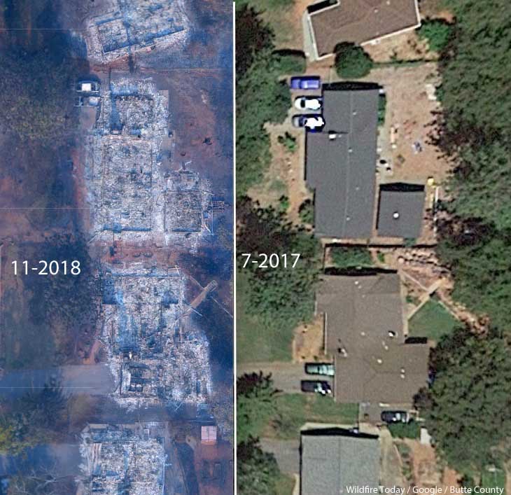
Some of the homes in Paradise, California that burned were less than 20 feet apart. According to measurements using Google Earth, the structures in the photo at the top of this article were 14 to 18 feet from each other.

Photo: Anchor Point Group, Boulder, CO

The National Institute of Standards and Technology released a report on the Waldo Canyon Fire that burned 344 homes and killed two people in Colorado Springs, Colorado in June, 2012. They concluded that current concepts of defensible space did not account for hazards of burning primary structures, hazards presented by embers, and the hazards outside of the home ignition zone. In addition, NIST recommended:

High-density structure-to-structure spacing in a community should be identified and considered in [Wildland Urban Interface] fire response plans. In the Waldo Canyon fire, the majority of homes destroyed were ignited by fire and embers coming from other nearby residences already on fire. Based on this observation, the researchers concluded that structure spatial arrangements in a community must be a major consideration when planning for WUI fires.

After studying the Carr Fire that destroyed 1,079 residences at Redding, California earlier this year, retired CAL FIRE Battalion Chief Royal Burnett reached similar conclusions.

It was easy to figure out why the houses on the rim burned — they were looking right down the barrel of a blowtorch. Even though they had fire resistant construction, many had loaded their patios with flammable lawn furniture, tiki bars and flammable ornamental plants. Palm trees became flaming pillars, shredded bark became the fuse, junipers became napalm bombs. Under current standards houses are build 6 to an acre; 10 feet to the property line and only 20 feet between houses. Once one house ignited, radiant heat could easily torch the next one.

We have to learn to live with fire

Reducing the chances that a fire in a populated area will turn into a disaster that burns thousands of homes involves at least three categories of factors, in addition to weather:

  • Envelope of the structure itself: characteristics of the roof, vents, siding, doors, windows, foundation, fences, eaves, and decks. A FEMA publication (13 MB) has excellent detailed recommendations. Headwaters Economics found that the cost of building a fire-resistant home is about the same as a standard home.
  • Home Ignition Zone, as described above — topography and fuel within 100 feet.
  • Community infrastructure and planning: distance to nearby structures, evacuation capability, safety zones, road and driveway width, turnarounds at the end of roads, signage, and emergency water supply. Again, the FEMA document has great recommendations.

Someone asked me recently what needs to be done to keep from repeating disasters like we have seen within the last year at Paradise, Redding, and the Napa Valley. I told him that there is no one thing that needs to be done, such as raking or “forest management”, it requires a comprehensive holistic approach.

The items we have listed here only apply within communities. There is of course much that can be done surrounding the places where people live that would reduce the vegetation or fuel and decrease the intensity and ember generation potential of a fire as it approaches an urban area. Large scale fuel management including fuel breaks and prescribed fire programs are usually conducted by state and federal agencies.

The weakest link in the chain principle applies here. If one of these categories is sub-par, the individual structures and the entire community in a fire-prone environment is at risk. And if a homeowner does not do their part, it can endanger their neighbors.

The warming climate is demonstrating that wildfires are becoming increasingly perilous. It is unlikely that local governments or states are going to ban development in fire-prone environments, but it is their responsibility to protect their citizens by enacting sensible standards.

New satellites can aid in management of wildfires

Imagery from GOES 16 showed dramatic smoke plumes from the Camp Fire

Screenshot from the GOES 16 time-lapse of the Camp Fire.

The NASA article below lays out how the agency believes the imagery from recently launched satellites can assist in the detection and management of wildfires.


GOES-16, operating as NOAA’s GOES East satellite, is proving to be an invaluable asset in detecting wildfires and helping forecasters provide proactive tactical decision-support services. The satellite’s main instrument, the Advanced Baseline Imager (ABI), offers three times more spectral channels, four times increased resolution, and five times faster coverage than the previous GOES imager. This means a much more detailed look at fire conditions, faster detection of hot spots, and the ability to track fire progression and spread in real time.

National Weather Service (NWS) incident meteorologists (IMETs) are using GOES-16 data to assist firefighting efforts. IMETs who deploy to wildfires are instrumental to the mission. An IMET’s first priority is to keep firefighters and the public safe amid rapidly changing wildfire conditions. During the peak of the Camp Fire in northern California in November 2018, the fire was advancing at a rate of over 100 football fields every minute. A shift in the winds could easily put firefighters in danger.

GOES East captured imagery of the Camp Fire in northern California on November 8, 2018. The wildfire developed in the early morning hours and spread quickly within very windy and dry weather conditions. Hot spots and a large plume of smoke are seen in this fire temperature RGB (red-green-blue) imagery is created with Advanced Baseline Imager bands 7, 6, and 5 (shortwave and near infrared bands), which are used to detect hot spots. To make this animation, the fire temperature imagery is made partially transparent and placed over a GeoColor enhancement, so both the fire’s hot spots and smoke plume are visible.

Timely satellite imagery is critical, life-saving information in a dynamic fire environment. In the past, IMETs had a single low-resolution image that updated every 15 minutes – typically the image was already 20 minutes old when it arrived to the forecaster. Now, GOES-16 frequently detects fires before they are spotted on the ground – often 10 to 15 minutes before emergency notifications to 911.

Alex Hoon, the NWS IMET for both the Camp and Carr Fires in California in 2018, says GOES-16 is crucial to an IMET’s mission to protect lives and property. “Now, forecasters are able to get incredible high-resolution images of the fire every single minute in the field, directly supporting firefighters who are engaged in the fire. Not only is this helping firefighters to more effectively fight fire, but more importantly, it’s helping to keep firefighters safe so that they can also come home to their families,” said Hoon.

GOES-16 is also used to pinpoint the exact location of a fire after reports of smoke. On July 2, 2018, the Pueblo County, Colorado, Emergency Management Office called the NWS Pueblo Weather Forecast Office (WFO) for assistance locating the source of smoke reported near Custer/Fremont/Pueblo County lines. GOES-16 showed a hotspot in northeast Custer County and the Pueblo WFO was able to provide the exact coordinates of what would become the Adobe Fire. Being in a remote and wooded area, the early and more precise geolocation of the fire was helpful for getting crews on the scene quickly.

GOES-16 observations are not just valuable for detecting wildfires but are also critical to observing and monitoring smoke from those fires. GOES-16’s ability to monitor smoke plumes in near-real time is particularly useful in directing firefighting efforts from the air. Deploying airplanes and helicopters to spray fire retardant is often hampered due to poor visibility. GOES-16 can help guide decisions for deploying flights by providing information on the exact location and motion of smoke from a fire. The smoke detection and monitoring information also enable better air quality forecasts.

The benefits from GOES-16 aren’t just seen during a fire but are also important in monitoring burn scars and predicting flash flood events from rain events after a fire. GOES-16 provides critical data for the entire lifecycle of a fire disaster – from drought to fire to floods and landslides.

The new capabilities from GOES-16 are a game-changer for fire weather forecasts and warnings. Soon, GOES-16 will be joined by its twin satellite, GOES-17, as NOAA’s operational GOES West. GOES-17 will provide even better resolution for U.S. West Coast firefighting efforts than GOES-16 due to its location over the Pacific Ocean.

New channels on the ABI provide more information to forecasters and the high resolution and rapid scanning give them high-definition images as often as every minute. Data from the ABI is helping forecasters locate hotspots, detect changes in a fire’s behavior, predict a fire’s motion, and monitor the post-fire landscape like never before. Providing this information to firefighters, emergency managers, and state and county agencies helps NOAA’s Satellite and Information Service meet its mission of protecting the nation’s environment, security, economy and quality of life.

A documentary about the Camp Fire at Paradise, California

There will probably be numerous documentaries released about the Camp Fire that erased much of Paradise, California as it killed at least 86 people and destroyed over 14,000 homes. Below is one of the first.

The fire will be an important part of California history, but it remains to be seen if it will be eclipsed in the next few years by even more unimaginable and disastrous fires as the climate becomes warmer and more prone to extreme events.

The film below, produced by Paradise-area film maker Golden Eagle Films, contains many interviews with residents that survived the inferno.


Thanks and a tip of the hat go out to Dave. Typos or errors, report them HERE.

California woman arrested who claimed fake firefighter husband to solicit donations

She is accused of defrauding individuals who believed they were donating to benefit firefighters working on the Holy Fire

Above: An S-2T air tanker comes past the smoke to drop retardant near the communication towers on Santiago Peak August 8, 2018 as the Holy Fire approaches. HPWREN image.

While the Holy Fire was burning last August in Orange and Riverside Counties in Southern California, a woman posted requests for donations on several social media sites. Ashley Bemis was arrested this week on multiple felony counts for collecting thousands of dollars worth of cash, food, and equipment that she said was going to be used to help firefighters working on the fire.

Ms. Bemis, 28, of San Juan Capistrano, posted pictures of herself and her fictitious firefighter husband asking for donations. She asked for items she claimed would benefit the firefighters working alongside her husband battling the blaze that ultimately burned more than 23,000 acres in the Cleveland National Forest and destroyed 18 structures.

Ashley Bemis. Orange Co. Sheriff’s Office

After the social media posts, multiple individuals and companies in San Clemente and the surrounding area contacted Ms. Bemis to donate. She is suspected of collecting more than $2,000 in donations, both cash and items like socks, sports drinks, water, and camping equipment, from individuals, stores and companies.

A captain with a local fire agency became suspicious of the requests and contacted the Orange County Sheriff’s Department to investigate. Investigators interviewed victims and obtained search warrants for Ms. Bemis’ vehicle, residence and garages.

San Clemente Police Services investigators also became aware, through additional social media posts from members of the community, of past fraudulent activity by Ms. Bemis, including multiple prior faked pregnancies in an attempt to illegally obtain money from unsuspecting victims.

She is being held on $50,000 bail.

Prosecutors looking at a dozen fire investigations that could implicate PG&E

camp fire smoke column
The Camp Fire, Friday morning November 9, 2018. SJSU FireWeatherLab.

Already on probation after the 2010 San Bruno gas line explosion that killed eight, injured 58, and destroyed 38 homes, the Pacific Gas and Electric Company could be responsible for causing November’s Camp Fire at Paradise, California and 12 other Northern California blazes that burned thousands of houses in 2017.

CAL FIRE investigators are looking at two possible PG&E power line failures that may have ignited the Camp Fire resulting in the deaths of 86 people. The agency has already prepared investigation reports on 12 fires from last year for which they believe PG&E likely violated state laws. It is now up to the seven county prosecutors and the state Attorney General to determine if they are going to file criminal charges.

PG&E’s actions before and after the gas line explosion in 2010 could be noted in combination with the recent fires likely caused by the electrical equipment, leading to additional probation controls imposed by the court.

Below is an excerpt from Wikipedia about the federal charges related to the gas line explosion:

“On April 1, 2014, PG&E was indicted by a federal grand jury in U.S. District Court, San Francisco, for multiple violations of the Natural Gas Pipeline Safety Act of 1968 relating to its record keeping and pipeline “integrity management” practices. An additional indictment was issued by the grand jury on July 29, 2014, charging the company with obstruction of justice for lying to the NTSB regarding its pipeline testing policy, bringing the total number of counts in the indictment to 28. Under the new indictment, the company could be fined as much as $1.3 billion, based on profit associated with the alleged misconduct, in addition to $2.5 billion for state regulatory violations.

“On January 21, 2017, PG&E was fined $3 million and ordered to perform 10,000 hours of community service for criminal actions of violating the Natural Gas Pipeline Safety Act and for obstruction of justice. In addition, it must institute a compliance and ethics monitoring program and spend up to $3 million to “publicize its criminal conduct”. These actions were imposed after the company was found guilty by a federal jury in August, 2016 of six of the twelve charges against the company in US District Court.”

Los Angeles Fire Department’s crew of volunteer firefighters

Los Angeles Fire Department's Crew 3 volunteers
Los Angeles Fire Department Crew 3 constructs fireline. Screenshot from LAFD video below.

Volunteer firefighters are the backbone of many fire departments around the world — many active departments have no paid personnel. Usually volunteer firefighters are found in small or perhaps medium-sized towns and cities, especially in rural areas.

I have to admit —  I was surprised to discover that the second most populous city in the United States has volunteer firefighters. Los Angeles, with a population of almost 4 million people, uses volunteers in their Fire Department on what they call Crew 3, a crew that uses hand tools to construct fireline on the edge of fires in order to stop the spread.

Every member on the crew must take the required online training courses, pass the Pack Test, and then participate in two weeks of field training.

Most of the crew members hope the experience on the crew will pave the way to a full time job with the fire department.