Lawsuit filed alleging steam engine train started 416 Fire

The fire burned over 54,000 acres north of Durango, Colorado in June, 2018

At least six local residents and business owners in the Durango, Colorado area have filed a lawsuit against the company that operates the steam engine-powered train that hauls tourists on a 50-mile route between that city and Silverton. The Durango & Silverton Narrow Gauge Railroad locomotive burns coal which heats water, converting it to steam. Similar powered trains are known to start fires when burning embers are produced along with the smoke. The suit alleges that the train started a fire on June 1  north of Durango that eventually burned over 54,000 acres in very steep terrain west of Highway 550.
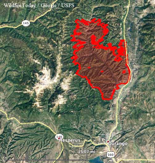
map 416 fire
The 416 Fire, July 4, 2018.

When the fire first started it was named the “Train xx Fire”. But instead of the “xx” there was a number, which gave the impression that a train had also started other fires in the area. After the fire quickly grew very large, the name was changed to “416 Fire”. The U.S. Forest Service investigated to determine the cause, but according to an article in the Durango Herald they have not released the results, which will likely be reviewed by Colorado State Attorney General’s office before they are revealed in late fall or early winter.

The people that filed the lawsuit claim the fire adversely affected tourism, causing a 5.6 percent drop in sales tax and a 13.2 percent drop in lodgers tax  over the same period in 2017.
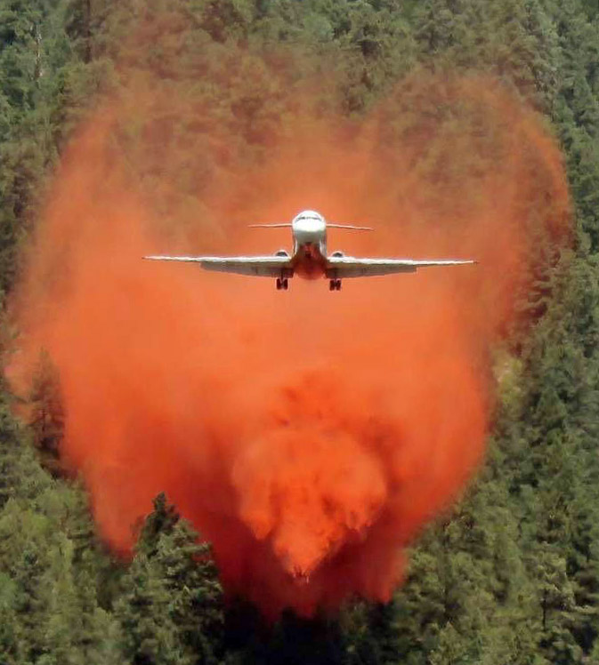
MD87 air tanker drops 416 Fire
An MD87 air tanker drops on the 416 Fire June 7, 2018. Photo by Dan Bender, La Plata County Sheriff’s Office.

Below are excerpts from the Herald’s article:

Plaintiffs say the company and its owner knew, or should have known, of the drought conditions that existed at the time the fire started.

The company did work to prevent this possibility. The train has its own firefighting tactics, such as having pop cars with water tankers follow a train to extinguish small fires and a helicopter to tackle fires from the air.

But plaintiffs say the railway operator was not equipped to extinguish this blaze. It had just laid off its veteran crew of firefighters at the beginning of the year, the lawsuit states, and replaced them “with employees much less experienced in fire mitigation and firefighting techniques.”

Fire crews “were unable to put down the fire because they were insufficiently trained by the defendant and/or because the firefighting equipment provided on the pop car was wholly insufficient to appropriately respond to the fire,” attorneys wrote in the lawsuit.

The video below is an interview with Cres Fleming who was the second person on scene at the 416 Fire June 1, 2018.

Thanks and a tip of the hat go out to Gary.
Typos or errors, report them HERE.

Fire activity picks up in Utah and Colorado

At least five large wildfires are growing in the two states

Above: Satellite photo at 5:37 p.m. MDT Sept. 13, 2018 showing smoke from wildfires in Utah and Colorado.

(Originally published at 7:16 p.m. MDT September 13, 2108)

The Red Flag Warning that brought strong winds and very low humidities Wednesday and Thursday contributed to the rapid growth of several wildfires in Utah and Colorado.

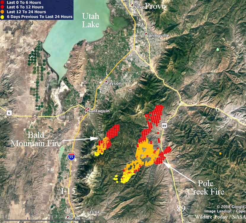
In Utah two fires about 18 miles south of Provo spread very rapidly Wednesday night and Thursday. The Pole Creek and Bald Mountain Fires, between Highways 54 and 89, are only about five miles apart. Two Type 1 Incident Management Teams are en route to these fires.  Todd Pechota’s team will manage the Bald Mountain Fire and Beth Lund’s team will take the Pole Creek Fire.

To see all articles on Wildfire Today about the Pole Creek and Bald Mountain Fires, including the most current, click HERE.

Map Pole Creek Bald Mountain Fires
Map of the Pole Creek and Bald Mountain Fires showing heat detected by a satellite as late as 2:36 p.m. MDT September 13, 2018.

At 2:36 p.m. MDT a satellite detected heat on the Pole fire indicating that it had spread over a relatively narrow path 14 miles long and had crossed Highway 89. This information from a satellite 200 miles overhead is preliminary and needs to be confirmed by someone closer to the ground.

The Bald Mountain Fire appeared to have spread about five miles. Both fires were pushed by strong southwest winds, causing them to grow to the northeast.

Our extremely rough very unofficial estimate of the size of the two fires in Utah, based on the 2:36 p.m. MDT satellite data on Friday — at that time the Bald Mountain Fire had burned approximately 2,000 acres and the Pole Creek Fire had grown to about 14,000 acres.

Two fires along Highway 318 in northwest Colorado 10 and 24 miles northwest of Maybell were quite active Thursday. They are named the Three Wash and Boone Gulch Fires.

The Silver Creek Fire 16 miles northwest of Kremmling, Colorado continued to spread toward Highway 40. Thursday afternoon it was about three miles west of the highway.

Silver Creek fire near Kremmling, Colo. awakens

The fire made a 4-mile run on Wednesday

Above: Airline pilot Chad Andrews photographed the Silver Creek Fire as it spread to the northeast September 12, 2018.

(Originally published at 10:15 a.m. MDT September 13, 2018)

The Silver Creek fire 19 air miles northwest of Kremmling, Colorado had been quiet for weeks, but strong winds and very low humidity on Wednesday brought it back to life in the Buffalo Park area. The 12 mph southwest wind gusting at 24 mph combined with 11 percent relative humidity caused the fire to spread four miles to the northeast, prompting fire officials to evacuate hunters in the area.

Our very unofficial analysis from satellite data indicates that approximately 1,100 acres burned Wednesday, which would bring the size up to 5,800 to 6,000 acres.

Silver Creek Fire
This is a screengrab from video footage shot Wednesday of the Silver Creek Fire by Colorado’s MultiMission Aircraft.

Additional firefighting resources are being ordered.

The fire is 19 air miles southeast of Steamboat Springs, west of Highway 40.

Map Silver Creek Fire
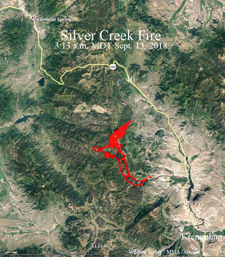
Map of the Silver Creek Fire. The red line was the perimeter on August 23. The red shaded area on the northeast side represents heat detected by a satellite at 3:13 a.m. MDT September 13, 2018.

Thursday’s weather forecast is not good news for firefighters. With a Red Flag Warning in effect it is a little more severe than conditions on Wednesday. Firefighters should expect southwest winds at 12 to 17 mph gusting up to 27 mph along with humidities as low as 9 percent. This could result in additional fire spread to the northeast if fuels are available.

Silver Creek fire
A photo posted on InciWeb September 3 showed a mosaic burn pattern on the Silver Creek Fire.

Introduction to the Benchmark fire lookout in Colorado

Above: Richard Freimuth and his wife staff the Benchmark fire lookout in southwest Colorado. Screen grab from the video.

The SWC Wildfire Coalition posted this video to You Tube featuring Richard Freimuth and his wife who staff the Benchmark fire lookout on the San Juan National Forest in southwest Colorado.

The description posted with the video:

Even in today’s high tech world, humans are still the best when it comes to detecting fires. A bygone, iconic fire watchtower and lookout still have relevance in today’s infrared satellite world.
https://www.facebook.com/SanJuanNF/

After demob, rental car rolls over

Driver suffered a broken right arm and left shoulder

Rental car rollover, Frisco, Colorado
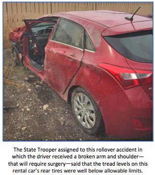
Rental car rollover, Frisco, Colorado.

Vehicle rollovers on fire assignments are not restricted to trucks, water tenders and dozers.

Below is the text from a Rapid Lesson Sharing report about an accident that occurred on Interstate 70 near Frisco, Colorado on August 21, 2018.


“Narrative
A Public Information Officer trainee was traveling in a rental car from the Cabin Lake Fire to Denver for a demob flight the following day.

“While driving on I-70 near Frisco, Colorado, she became caught in a severe storm with heavy rainfall. Her vehicle began to hydroplane, went off the road, and overturned.

“She received a broken right arm and left shoulder, was treated at a local hospital, and kept overnight. When she returns home, she will require surgery.

“Lessons

  • “The State Trooper investigating this accident said that the tread levels on rental car’s rear tires were well below the allowable limits.
  • With all the mobilization that’s going on around the West right now, there are surely a lot of vehicles being rented from various sources.
  • We look for dents and dings when we pick up a rental vehicle, but rarely think to check for tire wear.”
    (end of report)

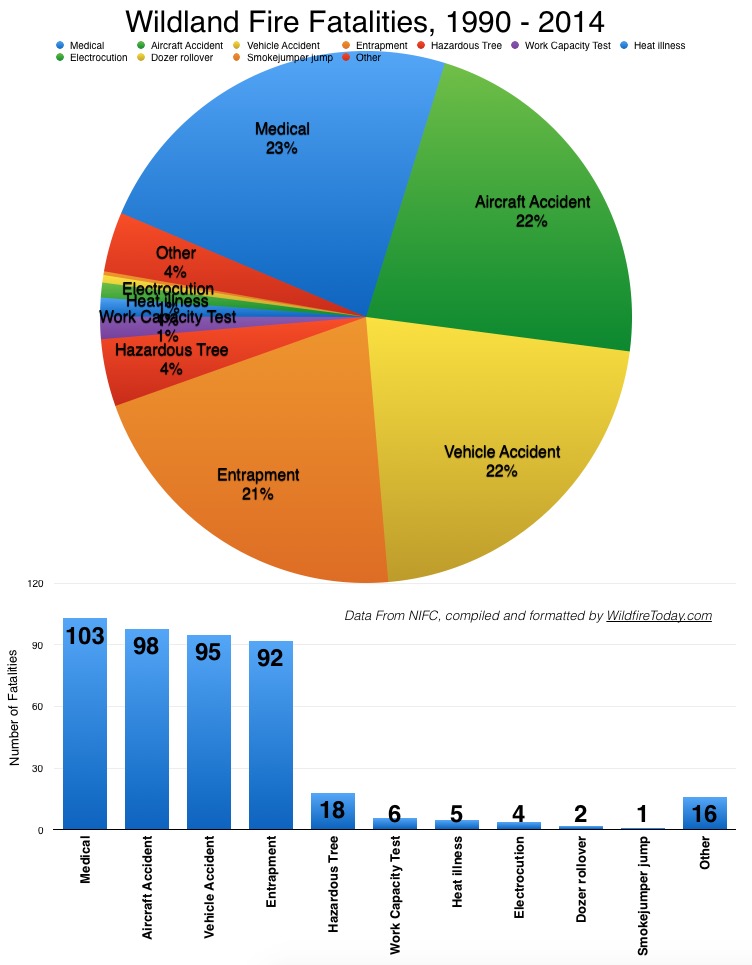
Almost a quarter of the wildland firefighter fatalities between 1990 and 2014 occurred in vehicle accidents.

Wildland firefighter fatalities 1990-2014

Wildfire activity increases in Colorado

Fires western Colorado
Fires in western Colorado, July 31, 2018.

After having received some monsoonal moisture, Western Colorado apparently is drying a bit, and has quite a few active fires.

Below is information provided by the Rocky Mountain Coordination Center July 31, 2018. Some of the larger ones that are active are listed below, north to south.

Cabin Lake: 350 acres, 103 personnel. White River N.F. ICT3 (Thompson) 16 miles SE of Meeker, CO. Fuel model 4 and 10. Extreme fire behavior with crowning, wind-driven runs and spotting. Residential structures and powerlines threatened. Road, trail and area closures in effect.

Red Canyon: 1,500 acres; 136 personnel. White River BLM. ICT4 (Jacob) 45 miles SW of Meeker, CO. Fuel model 5 and 2. Moderate fire behavior with running, uphill runs and spotting. Residential structures, oil and gas infrastructure and FAA Tower threatened. SWA IMT (Andrews) transition of command anticipated 2400 7/30.

Cache Creek: 325 acres; 50 personnel. White River N.F. ICT3 (Spetter/Ottoson(T)) 8 miles SW of Rifle, CO. Fuel model 10. Moderate fire behavior with single tree torching, group torching and long-range spotting. Oil and gas infrastructure, watershed and private timber interests threatened. RMA IMT2 (Esperance) in-brief 2000 7/30.

Lake Christine: has been burning since July 3, 2018. 12,588 acres, 313 personnel. Eagle County. RMA IMT2 (Greer). One mile NW of Basalt, CO. Fuel model 8 and 2. Minimal fire behavior with smoldering and creeping. Threat to residential structures, private inholdings and high voltage transmission lines, communications infrastructure, water supply infrastructure, commercial airline corridor. Road, area and trail closures in effect. Transfer of command to local IMT3 (Anderson) planned for 7/31. Expected containment 8/2.

Buttermilk:  671 acres, (no more information)

Plateau: 1,200 acres, 87 personnel. San Juan N.F. ICT3 (Seekins/Stark (T)). 13 miles N of Dolores, CO. Fuel model 10 and 2. Moderate fire behavior with short range spotting, isolated torching, group torching and wind driven runs. Road and area closures in effect.