Update and map of the Fourmile fire near Boulder, Sept. 8

UPDATE @ 8:00 p.m., Sept. 8

The Rocky Mountain Area Coordination Center had the following update about the Fourmile fire at 7:20 p.m. today:

Four Mile Canyon Fire Update: (CO-BLX) , 5 miles west of downtown Boulder, CO. Single tree torching with creeping in Douglas-fir, Ponderosa pine and grass was observed today. Transition expected from Type 2 (Richardson) to Type 1 (Thomas) will occur at 1800 Tomorrow. Red flag predicted for tomorrow for high winds and low humidity. Currently at 6,365 acres, 10% contained.

=====================================

UPDATE @ 6:15 p.m., Sept. 8

The Boulder County Sheriff’s Office has provided a list of 140 structures that have been destroyed by the Fourmile Canyon wildfire and another 24 that have been damaged by the fire.

======================================

UPDATE @ 4:00 p.m., Sept. 8

My favorite quote so far about the Fourmile fire is from an article today at the Daily Camera:

The fire burned in on itself, shrinking its overall size to 6,168 acres.

We need to figure out how to harness that technology or phenomenon, whatever it is, but it might put firefighters out of a job.

By the way, some of the comments on that article are interesting.

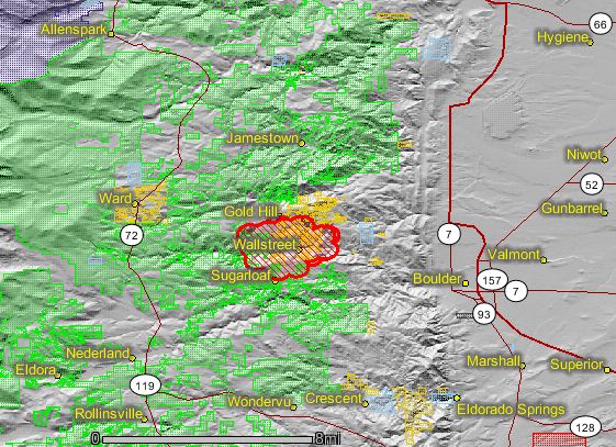
Boulder County has posted a new map of the fire.

======================================
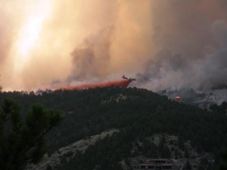
Fourmile fire air tanker
Air tanker making a drop on the Fourmile fire, Sept. 6, 2010. Photo: InciWeb

UPDATE @ 1:05 p.m., Sept. 8

Adam K. plotted the locations of the structures that have been reported by the Boulder Office of Emergency Management as having burned as of 9:42 p.m. on September 7. The information is preliminary and incomplete, and Wildfire Today assumes no responsibility for the accuracy of the data. Here is how the list of addresses with burned structures was described by the Boulder OEM:

9:42 p.m. – Sept. 7, 2010 – The Boulder County Sheriff’s Office is providing this information to residents who have been affected by the fire. The addresses listed below are of houses that the Sheriff’s Office has identified as destroyed by the Fourmile Canyon Fire. These addresses were determined from only 5-10% of the burned area, as that is the only area that could be safely surveyed today. Some parts of the burned area are more densely populated than others. In most cases, Sheriff’s deputies were able to identify addresses by the homes’ mailboxes, some of which are grouped with other mailboxes, so while we intend this to be an accurate list of addresses, we are working under difficult conditions in determining the actual address of each home.

We will continue to post more information as it becomes available following additional investigative work on Wednesday.
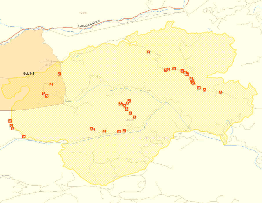
Fourmile fire preliminary map of burned structures
An overview map.

More detailed maps:

West side

Northeast side

Center area

Thanks Adam.

There is a report that nine volunteer firefighters lost their homes in the fire.

.

Continue reading “Update and map of the Fourmile fire near Boulder, Sept. 8”

Update and map of Fourmile fire near Boulder, Sept. 7

UPDATE @ 10:50 p.m., Sept. 7

The Boulder Office of Emergency Management, after surveying 5-10% of the burned area, has identified 53 houses that have been destroyed by the Fourmile fire. Due to the fire activity, they were not able to collect data in other areas.

ABC7 has information about the early stages of the fire, including transcripts from radio conversations and a report that a vehicle colliding with a propane tank may have started the fire.

At 8 p.m. the Rocky Mountain Area Coordination Center reported:

Type 1 Incident Management Team, Thomas in briefing at 1000 on 09/08. 6,128 acres. IR [fixed-wing Infrared] flight tonight to determine size. Counting of structures lost will begin tomorrow. 20 Subdivisions west of Boulder have been evacuated and 3 major county roads are closed. Fire is growing around the entire perimeter. Crowning, running, and spotting fire behavior has been observed.

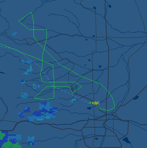
In fact, one of the US Forest Service infrared aircraft, a Super King Air 200 twin-turboprop, N149Z, has already flown over the Fourmile fire, and it looks like the Cow fire in Rocky Mountain National Park as well. The map below shows the aircraft’s flight path as it arrived into the area from Boise, flew over the two fires, possibly dodged some rain or thunderstorms, and landed at Rocky Mountain Metro Airport at 8:08 p.m. It has the capability to downlink the digital imagery wirelessly via Aircell while airborne. Then an Infrared Interpreter retrieves the files from a server, analyzes the data, produces a map showing the heat sources, draws an accurate fire perimeter, and calculates the acreage of the fire.

So, within a matter of hours we should have an accurate fire perimeter and acreage.

Infrared flight track

=========================================

UPDATE @ 6:15 p.m., Sept. 7

At a 4 p.m. press briefing today fire officials said that 7,100 acres had burned (later changed to 6,168 acres at the InciWeb site) and the fire had forced the evacuation of 3,000 residents. An inversion in the morning prevented air tankers from taking off, but later in the day eight air tankers had dropped 90,000 gallons of fire retardant by the time of the briefing. Three helicopters are also working on the fire. About 2,000 residences are without electricity in the fire area. With about half of the burned area being surveyed, they have identified 63 structures that have burned.

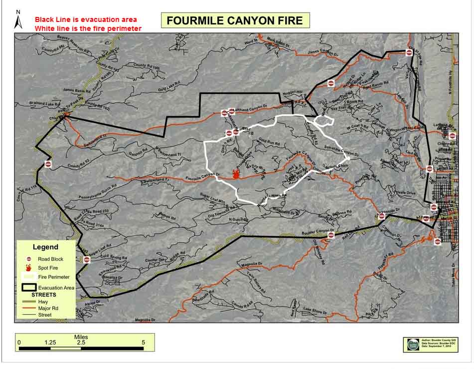
Here is a map produced today by Boulder County showing the perimeter and the evacuation area for the Fourmile fire. (We added the notes in red at the top.) The original higher resolution version of the map is HERE.

Click the map to enlarge it.

Fourmile fire evacuation and perimeter

Another map of the fire perimeter can be found at the InciWeb site.

=============================================

UPDATE @ 5:00 p.m., Sept. 7

Here are some updated maps of the Fourmile fire near Boulder, Colorado.

Fourmile fire map perimeter
The perimeter of the Fourmile fire, as of 6:00 a.m. Sept. 7, 2010. Click to enlarge.
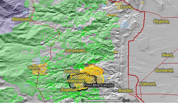
Fourmile fire map
Map of the Fourmile fire, showing heat detected by satellites at 1:05 p.m. on Sept. 7, 2010. The yellow line with the cross-hatching is the perimeter as mapped by firefighters today.

HERE is a link to a topographic map showing the fire perimeter as of noon today, but it is difficult to make out much detail.

Continue reading “Update and map of Fourmile fire near Boulder, Sept. 7”

Fast-moving wildfire near Boulder, CO burns a fire truck and thousands of acres

UPDATE @ 9:00 p.m., Sept. 6

CBS4 in Denver is reporting that  four of the firefighters who were working on the fire lost their homes in the blaze, according to Laura McConnell of the fire’s Incident Management Team. After they were notified, they were released from the fire.

CBS4 also reports that the fire has burned 3,500 acres. The Rocky Mountain Area Coordination Center reported at 7:45 p.m. that the fire had burned 3,000 acres and 12 structures.

There is another time-lapse video of the fire HERE.

====================================================

UPDATE @ 6:21 p.m., Sept. 6

According to Boulder Channel 1 news, the Fourmile fire near Boulder started when a propane truck crashed in Fourmile Canyon.

Sometime after 5 p.m. today the winds decreased enough to allow the first air tankers to be dispatched to the fire. They had been staged at Rocky Mountain Metro Airport, waiting for weather conditions that would allow them to safely attack the fire.

Fourmile fire near Boulder air tanker drop
After 5:00 p.m. on Monday, air tankers were first able to work the fire after the strong winds decreased. Photo: Graham Stewart

===================================================

UPDATE @ 5:00 p.m., Sept. 6

Here is 17-second time-lapse video showing 6 minutes of fire activity on the Fourmile fire near Boulder, Colorado.

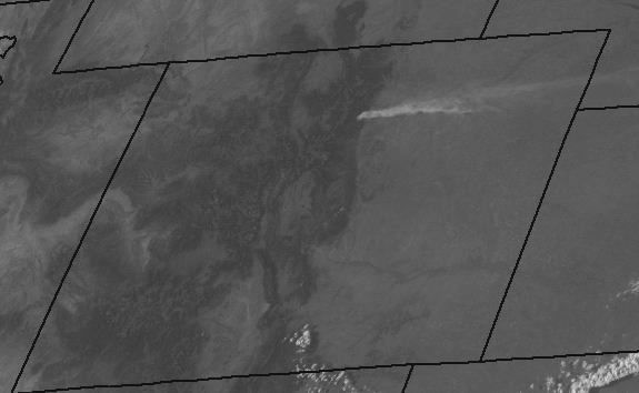
Fourmile fire map
This satellite photo of the Colorado shows smoke from the Fourmile fire being pushed by a strong west wind, at 4:50, 9-6-2010.

==============================================================

UPDATE @ 4:20 p.m., Sept. 6

The maps below of the Fourmile fire near Boulder show heat that was detected by the MODIS satellite earlier today.

Map of the Fourmile fire near Boulder
Map of the Fourmile fire northwest of Boulder, showing heat detected by a satellite in the afternoon of Sept. 6, 2010

Continue reading “Fast-moving wildfire near Boulder, CO burns a fire truck and thousands of acres”

South Canyon fire, 16 years ago today

South Canyon Fire
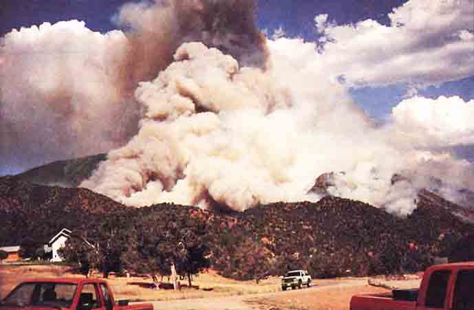
The blow-up at the South Canyon fire, between 1630 and 1700. Photo from the report.

On the afternoon of July 6, 1994 near Glenwood Springs, Colorado the South Canyon fire spotted across the drainage and beneath firefighters, moving onto steep slopes and into dense, highly flammable Gambel oak. Within seconds, a wall of flame raced up the hill toward the firefighters on the west flank fireline. Failing to outrun the flames, 12 firefighters perished. Two helitack crew members on top of the ridge also died when they tried to outrun the fire to the northwest. The remaining 35 firefighters survived by escaping out the east drainage or by seeking a safety area and deploying their fire shelters.

The firefighters who lost their lives that day:

Kathi Beck
Tami Bickett
Scott Blecha
Levi Brinkley
Robert Browning
Doug Dunbar
Terri Hagen
Bonnie Holtby
Rob Johnson
Jon Kelso
Don Mackey
Roger Roth
James Thrash
Richard Tyler

For more info.

Terry Barton released from prison

Terry Barton, convicted of starting the 138,000 acre Hayman fire in 2003, was released from prison this morning. She started the fire while she worked as a Fire Prevention Technician on the Pike National Forest in Colorado.

The fire burned 133 homes and forced 8,000 people to evacuate, including the judge who presided over one of the proceedings related to the case. She served six years in a federal prison in Fort Worth, Texas.

Wildfire Today covered other aspects of this story HERE.

The picture is from 2002 when she appeared in court, courtesy of the Denver Post.

CO: Details about SEAT crash

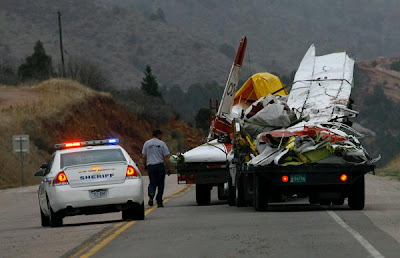
More information has been released about the single engine air tanker that crashed on April 15 near Fort Carson in Colorado.

Gert Marais reported a mayday and said, “I’m going down,” just before his single-engine air tanker crashed while fighting the 9,800-acre Fort Carson fire last week, the National Transportation Safety Board reports.

But the preliminary report from the NTSB does not identify a crash cause.


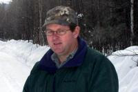
Marais, 42, of Fort Benton, Mont., (see photo below) was a pilot and mechanic and worked as a contractor for Aero Applicators of Sterling.

The Colorado State Forest Service had called the company to help fight the fire.

Two planes left Sterling at 5 p.m. with full fuel tanks, 500 gallons of water and Class A foam, the report said. Marais was flying an Air Tractor AT-602.

When the planes arrived at the site, a U.S. Forest Service agent on the ground maderadio contact to give the pilots directions.

The agent worked with Marais to do a practice run over the drop site, a line of pine trees to the north of a gravel road bordering the wildfire. The goal was to douse the trees in case the fire jumped the road.

Marais flew over the site, the NTSB report said, with the other plane about 500 feet overhead as a spotter.

Then Marais made the real drop. He flew over the top of a tall pine tree and released his load 500 feet west of the target, right on top of the U.S. Forest Service agent and his car.

A second or two later, the agent told investigators he heard Marais report a series of maydays and say, “I’m going down.”

The agent watched the plane’s right wing hit the ground on a grassy hill just off Colorado 115. The time was 6:10 p.m.

The tanker landed upright, with the right wing and fuselage crushed. The U.S. Forest Service agent told investigators that wind gusts at the time were 30 to 40 knots.

Fire investigators with the U.S. Army and the El Paso County Sheriff’s Office have yet to release the cause and specific point of origin of the fire on the base, which was declared fully contained Wednesday.

A funeral for Marais, who was a native of South Africa, will be Friday in Montana.

His wife, Esme, and the couple’s children had planned to move to Sterling this summer.

The couple were married 10 years ago this month. He was already caring for three of his children from a previous marriage, ages 19, 17 and 12, and together he and Esme had a 5-year-old.

Photos and excerpt courtesy of the Denver Post.