Firefighters in Minnesota say the video provided by a drone gave them critical information and situational awareness at a propane fire near Callaway on March 24. The 200-person town was evacuated when a propane tanker truck collided with a freight train, causing a major derailment and fire.
Propane fires can be extremely dangerous. A BLEVE — Boiling Liquid Expanding Vapor Explosion — can kill anyone nearby.
…Piloted by a Perham firefighter, the drone flew over the scene of a derailment and propane tanker truck fire last week, giving firefighters a critical bird’s-eye view of the dangerous situation, said Callaway Fire Chief Keith Heinlein, who was in charge at the scene.
“My decisions are only as good as the information I have,” he said.
Information from the drone was invaluable, letting firefighters see “what was burning and where,” including areas that were blocked from view because of overturned grain cars, he said.
Emergency responders watched the live video feed from the drone on a screen inside their on-site command center.
Heinlein said they were joined in “the war room” by Cenex Harvest State Propane professionals who, thanks to the drone video, could see the propane tanker burning, including close-ups of valves and other parts, “and tell us exactly what was happening,” he said.
The propane tanker truck burned for about 10 hours, all the while being cooled by a steady stream of water shot by firefighters, before the liquid propane had burned off and was replaced by more volatile propane gas, Heinlein said.
The propane fire got too hot at one point and the tanker vented, causing a visible flare-up before firefighters cooled it down again, Heinlein said.
Later it heated up again in spite of firefighter efforts to keep it cooled down. “We got behind it,” couldn’t keep it cool enough, and it exploded, Heinlein said…
The Kiowa County Media Center, a non-profit organization, shot this very impressive footage of the Anderson Creek Fire that has burned close to 400,000 acres in Kansas and Oklahoma. They uploaded it to YouTube on March 25, 2016.
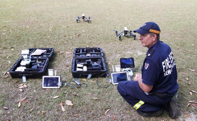
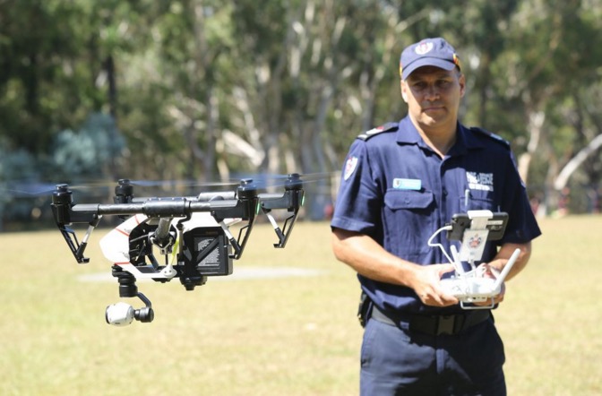
Fire and Rescue New South Wales (FRNSW) recently introduced to the Australian public examples of a multi-million-dollar batch of new technological devices they have added to the firefighters’ tool box.
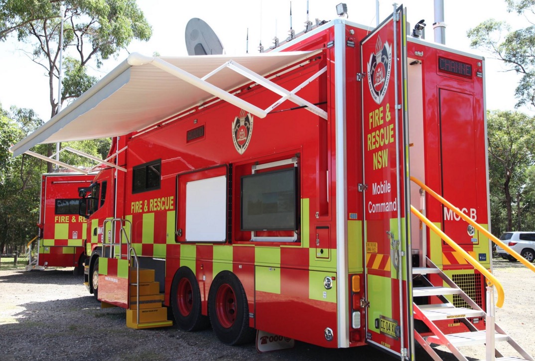
Drones are the latest weapon in the fight against fire, chemical spills and natural disasters, providing firefighters with real-time images of areas too dangerous to access and enabling rapid damage assessments. Two new drones are part of this new package, which also includes two custom-built mobile command centers and the installation of more than 180 mobile data terminals in fire trucks across NSW.
Below is an excerpt from an article at Mashable:
The two mobile command centres feature radio and video feeds, as well as communication services such as high-speed satellite and 4G. The mobile data terminals will give firefighters access to weather data and local hydrant, gas and electricity maps as they head to incidents.
The drones, paired with six trained firefighters to operate them, will give response crews a view of the emergency site from above, whether during a fire, flood or chemical spill.
“Each vehicle has high speed internet and a 100-meter Wi-Fi bubble which could be invaluable to communities cut off from technology following a catastrophic fire or storm event,” Fire and Rescue NSW Commissioner Greg Mullins said in the statement.
“This new technology improves the information available for first responders and will ensure that we remain a world class fire, rescue and hazmat service.”
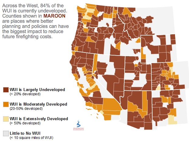
Headquarters Economics released a report about how five cities have used innovative land use planning techniques as a way to adapt to the growing threat from wildfires. The authors met with city planners, elected officials, and firefighters in Austin, Texas; Boulder, Colorado; Flagstaff, Arizona; San Diego, California; and Santa Fe, New Mexico—all communities with a recent history of wildfire and a reputation for being problem solvers.
Headwaters Economics
Prescribed fire escapes in Florida
In St. Johns County, Florida on Tuesday a prescribed fire intended to treat 140 acres off County Road 208 escaped control when an unexpected 20-25 mph wind gust scattered burning embers. About 270 acres later the Florida Forest Service was able to contain the blaze.
Spokesperson Julie Maddux said statewide in 2015 the Florida Forest Service burned more than 236,000 acres during prescribed fires and none of them got out of control.
U.S. Forest Service releases findings on the effects of drought for forests and rangelands
“Our forests and rangelands are national treasures, and because they are threatened, we are threatened,” said Agriculture Secretary Tom Vilsack. “This report confirms what we are seeing, that every region of the country is impacted by the direct and indirect effects of drought conditions and volatile weather patterns. Sixty million Americans rely on drinking water that originates on our 193 million acres of national forest and grasslands. They support 200,000 jobs and contribute over $13 billion to local economies every year.”
Utah seeks jail time for drone operators that interfere with wildfire operations
Last year there were numerous instances across the West of drones flying into the airspace above active fires and interfering with the operations of firefighting aircraft.
From the AP:
..A new proposal in the Utah Legislature aims to address the growing problem by creating a possible penalty of jail time for people who fly drones within 3 miles of a wildfire.
A House committee was scheduled to discuss the proposal Tuesday afternoon but the hearing was postponed.
Republican Rep. Kraig Powell of Heber City, the proposal’s sponsor, said he asked to postpone the meeting so he could get more input from interested parties. He said he may add exemptions for certain entities, such as public utility companies that need to use drones to see if the fire will impact gas lines.
Jason Curry of the Utah Division of Forestry said he hopes lawmakers back the bill…
“I really hope it doesn’t take a major mishap and somebody to lose their life for the public to take it seriously,” Curry said.
Washington state treats less land with prescribed fire than their neighbors
Washington lags far behind neighboring states in using controlled burns to thin out dangerously overgrown woodlands.
After back-to-back years of catastrophic forest fires, some state lawmakers want that to change.
“I’ve had it. I think it is time to delve into the policy,” said state Sen. Linda Evans Parlette, R-Wenatchee, who represents a large swath of North Central Washington scorched in last year’s record-setting fires that burned more than 1 million acres.
Parlette is sponsoring a pair of “fight fire with fire” bills that would require more controlled burns on state lands and loosen smoke regulations to make it easier for federal and private land managers to conduct burns.
Experts say expanding the use of controlled burns is vital to restoring forests to health, leaving them less vulnerable to massive blazes when the summer fire season hits.
But some U.S. Forest Service officials and other critics say the state’s Department of Natural Resources (DNR), led by Commissioner of Public Lands Peter Goldmark, has discouraged controlled burns in recent years because of fears over smoke drifting into communities.
Firefighters found the body of a 90-year-old man in a brushfire on November 3 near Bainbridge, Ohio. Preliminary indications are that Melvin B. Elliott was raking leaves during the early stages of the fire, but the cause of death has not been determined.
California city bans drones during emergencies
The city council of Poway, California passed a new ordinance this week that prohibits launching, operating or landing drones in any part of the city where an emergency has been declared. The objective is to eliminate conflicts between unmanned aerial vehicles and helicopters or fixed wing aircraft responding to the incident. Several times this year hobby drones flown near wildfires have required firefighting helicopters and air tankers to be grounded for safety reasons.
Efforts to wrest control of federal lands can’t be ignored
The movement to grab federal lands, such as national forests, BLM land, and national parks, and turn it over to states or private landowners can’t be ignored. The efforts are real and are not going away. At least 37 land transfer bills have been introduced in state legislatures with six of them passing; another four have been finalized as “study” legislation.
Below is an excerpt from an article in Wyofile written by Angus M. Thuermer Jr., in which the view is expressed that one of the tactics is to starve federal agencies by reducing their funding, then accuse them of mismanagement, and arguing that states, individuals, or large companies would be better land managers.
[The views of Whit Fosburgh, president and CEO of the Theodore Roosevelt Conservation Partnership] illuminate the seriousness with which some in the conservation community are now viewing the renewed Sagebrush Rebellion. The movement is supported by a strategy that’s decades old — starving land management agencies — transfer critics say. Launched under the guise of deficit reduction and fiscal responsibility, budget cutting is also a cynical ploy to sow dissatisfaction of federal western land management at the grassroots level, Fosburgh contends.
Typically when aerial ignition is used to light a prescribed fire or a burnout operation on a wildfire, it is done with a large plastic sphere dispenser mounted in a conventional helicopter, as in the photo below.
Dennis Kirkley of Kaibab Helitack loads the plastic sphere dispenser (ping pong ball machine) with plastic spheres. Grand Canyon Helitack’s A-Star was used to do aerial ignition on the Sitgreaves Complex in northern Arizona August 8, 2014. Photo by Tom Story.
The University of Nebraska is developing an unmanned aerial vehicle that can use plastic spheres to ignite fires. What could possibly go wrong?
Below is an article from the university written by Leslie Reed.
****
Sebastian Elbaum (from left), Dirac Twidwell and Carrick Detweiler have developed a new patent for setting range fires with small drones. The drone injects a liquid into plastic spheres to start a delayed fiery process that allows the balls to fall to the ground before igniting. Elbaum and Detweiler are holding flaming tennis balls similar to those carried by the drones. University of Nebraska photo by Craig Chandler.
A new drone under development at the University of Nebraska-Lincoln could change the way wildfires are fought – and encourage the use of prescribed burns for conservation purposes.
The Unmanned Aerial System for Fire Fighting, or UAS-FF, is under development by a multidisciplinary team of UNL experts in drone technology, fire ecology, conservation and public policy.
The Great Plains, California and other locations around the world are seeing an increasing number of bigger and more intense wildfires in recent years, said Dirac Twidwell, a team member and a range ecology expert and faculty member in the Department of Agronomy and Horticulture.
Twidwell said it’s a trend that results from land management practices, including a decline in human use of fire for ecosystem management, as well as exotic species invasions, drought and climate change.
The aerial robot would have the ability to ignite and monitor fires in remote areas. Novel technology would allow it to operate in harsh environments with limited supervision, enhancing the capabilities of fire management personnel.
“The idea is to provide a safe mechanism for people to perform fire management tasks with less risk and higher efficiency,” said Sebastian Elbaum, a computer science and engineering professor and drone researcher.
The team has successfully performed indoor tests on a prototype. Carrick Detweiler, a faculty member in the computer science and engineering department, said the researchers have been working with the Federal Aviation Administration and hope to have authorization from the FAA and fire departments for a field test of the fire-starting drone as early as March.
“Unmanned aerial devices have the potential to carry out key resource management strategies and could help us deal with something as big as the international increase in severe wildfires,” Twidwell said.
Prescribed burns, where grasslands are burned off according to a predetermined plan, are widely recognized as an effective conservation tool that eliminates invasive species, restores native plants and reduces the risk of wildfire. However, they are underutilized because of perceived safety concerns.
A recent study from Twidwell’s lab shows prescribed fires are actually less less risky to landowners than other commonly used management techniques, and using drones would further reduce the risks posed by lighting prescribed burns by hand and using all-terrain vehicles and suppression vehicles in rough and remote areas.
Many federal agencies use helicopters to ignite such areas, but it’s too costly to use helicopters on private lands.
Elbaum and Detweiler built upon their prior research as co-founders of the Nebraska Intelligent Mobile Unmanned Systems, or NIMBUS, Laboratory to design aerial robots small enough to fit in a firefighter’s backpack, yet smart enough to safely interact with the environment
The drones carry a cargo of ping pong-like balls filled with [a chemical]. Before being dropped through a chute, each ball is manipulated and injected with [another chemical], creating a flame after several seconds. A similar method now is used to start fires for conservation purposes with helicopters and hand-held launchers, Detweiler said.
“We wanted to use proven technology that the prescribed-burn community is already familiar with,” he said.
The drones would have the ability to drop the balls in a precise pattern over the landscape – on the perimeters and interior of a rectangular plot, for example. Detweiler said the robots could be programmed so they don’t fly into areas that are too hot or windy for safe use.
The team is seeking grant funding to develop the next generation prototype with more sophisticated sensing and actuation capabilities, including the ability to operate as a swarm.
Other team members are Craig Allen, research professor and director of Nebraska Cooperative Fish and Wildlife Research, and Lisa Pytlik Zillig, research associate professor at UNL’s Public Policy Center. James Higgins, a mechanical engineering graduate student, designed the prototype’s mechanics, while Christian Laney, a computer science and engineering undergraduate student, was responsible for the control electronics.
The drones could be an especially effective tool in battling Eastern Red Cedar, an invasive tree species that some experts view as one of the region’s most serious ecological threats. It causes extinctions of many grassland plants and birds, collapses forage production important to the beef industry and is contributing to dangerous wildfires.
Detweiler and Elbaum said the drones also might be used in place of manned aircraft and hotshot teams of firefighters dropped by parachute in some wildfire-fighting situations.
“What we’re doing is supporting the expert and the user in the field,” Elbaum said. “The drone and the operator work together to make the job safer, more efficient and cheaper.” “
Launching an Aerosonde Mark 4.7. Aerosonde file photo.
Managers on the Tepee Spring Fire on the Payette National Forest in Idaho are testing a drone, or unmanned aerial system (UAS), collecting intelligence at night when other firefighting aircraft are grounded. Below are excerpts from an AP article:
Testing of the 55-pound craft with a 12-foot wingspan [was] scheduled to start Thursday night [September 17, 2015], Air Operations Branch Director Gary Munson of the U.S. Forest Service said. “If the night flights go well, we hope to gradually integrate it into daytime operations,” Munson said.
The Aerosonde Mark 4.7 operated by Textron Systems launches from a catapult and is recovered with a large net. It can cruise at up to 70 mph. The company in an email to The Associated Press said the system has more than 100,000 flight hours with flights in hurricanes and in the Arctic, but this is its first use on wildfires.
The “aircraft’s sensors can give responders real-time date on fire growth, burn intensity, fuels and heat concentrations,” the company said. It also said data supplied by the vehicle can be used by fire managers to look at erosion risks and impacts on wildlife and vegetation in remote areas.
Brad Koeckeritz, unmanned aircraft manager for the U.S. Department of the Interior, said the tests in Idaho are one of three demonstrations being done this fire season and include two other companies. Earlier this summer, officials tested a drone made by Boeing subsidiary InSitu on a wildfire in Washington states’ Olympic National Park.
“It was very successful,” Koeckeritz said. “We were able to look through very thick smoke and assist the helicopter pilots with bucket drops and see where the drops hit.”
The article states a couple of times that the sensors on the UAS can see through clouds, but I would be very surprised if that is true. (We didn’t include those sections here.) The moisture in clouds has its own heat signature which is impenetrable to the equipment on the U.S. Forest Service infrared line scanning aircraft. The sensors can detect heat through smoke, however, as long as it is not an extremely active convection column with a great deal of particulate matter, debris, or burning embers.
The video below demonstrates how the Aerosonde UAS is used on a ship.
The Aerosonde Mark 4.7 is recovered at the end of the flight by flying into a net deployed from the trailer-mounted launcher. Screen grab from Aerosonde video.
This Rapid Lesson Sharing, below, about a fire in southern California was distributed by the Wildland Fire Lessons Learned Center.
****
“At approximately 1430 hours, a report is radioed to Dispatch of a 1/4-acre vegetation fire located directly behind our Mill Creek Fire Station. Stepping outside the office, my swamper and I see heavy smoke to the north of the compound. We quickly make our way to the transport to off-load the dozer and engage the fire.
Upon size-up of the rapid rate-of-spread and eliminating the option of anchoring at the heel and cutting direct due to steepness of terrain, I prioritize my tactics to protection of life and property. I then make a decision to track my dozer up an indirect route—knowing there are homes and property owners at risk at the top of the ridge in the fire’s path.
At this point, one ridge to my north separates the ridge I am tracking up and the main fire. Air resources are enroute. At the pace I am ascending the ridge, I figure the air resources will arrive on scene and slow the forward rate-of-spread down long enough to allow me to reach the homes.
Fire Advances Toward Homes
As I crest the ridge, I only have a shallow drainage to cross—in which the fire has established itself just below me and is making a strong push toward the homes. At that moment, emergency traffic airs over command frequency that all aircraft have been grounded due to a drone sighted in the fire area.
As the fire advances, I make eye contact with the property owner across the drainage. At this time, the only option I have is to hope the fire will crest the ridge and minimize in intensity long enough for me to cross the drainage to the homes.
I take a moment to size-up and reevaluate my escape route and safety zone and try to develop a contingency plan with my swamper.
Drone Operator Confronted
Fortunately, the fire does as I had hoped. My swamper and I are able to cross the drainage and engage the fire directly, assisting the crews and engine personnel behind the threatened homes. Next, the drone clears the area and air suppression resources reengage.
When the drone is spotted returning, a U.S. Forest Service employee is able to follow it and confront the person responsible. His vehicle information is documented and he is notified that the authorities are enroute to educate him on drone use in wildfire areas.
However, the drone operator refuses to wait and flees the scene.
LESSONS
With the recent high frequency of drone use affecting wildfire suppression tactics, this incident has raised my awareness to the impact that drones have on wildfire suppression tactics.
In the future I plan on being more cautious when implementing air support into my tactical decisions and suppression efforts.”
****
Note from Bill: I know someone will say planned firefighting tactics should not depend on the predicted availability of aviation resources. However, to give the dozer operator the benefit of the doubt, his initial plan may have been to wait for the expected retardant drops to slow the spread of the fire before he committed himself to crossing the drainage to defend the structures.
Saskatchewan Premier wants a national fire cache and a fire mapping plane
The Premier of Saskatchewan, Brad Wall, wants the national government to establish a national cache of firefighting supplies and equipment that could be distributed when a province, or provinces, have multiple large fires ongoing. Perhaps he is thinking of a system similar to the one used in the United States, which has a national cache in Boise at the National Interagency Coordination Center.
“Some of those basic things that we would normally just call Manitoba or B.C. and say, ‘We need these things,’ well they were all fighting fires,” Mr. Wall said Wednesday. “Why, as a country, wouldn’t we have a cache? A national store to draw from if there is an occasion again where so many provinces are involved in fighting major fires?”
Mr. Wall also would like the see Canada acquire and operate a fire mapping plane that would use infrared detection equipment to see through smoke to map the perimeters and intensely burning areas of wildfires.
“If we could have at least one of those available nationally to provinces, because when it’s smokey, you have this whole flight … that’s grounded, and you might lose a little bit of ground that you might otherwise gain in better weather,” Wall said.
Wall will raise the idea at the premiers meeting in St. John’s, where he was heading on Wednesday.
Another drone shuts down aerial firefighting equipment
Sunday afternoon firefighting air tankers had to cease their operations on a fire near Yucaipa, California for about eight minutes when a drone was spotted over the fire.
Firefighting soldier takes bathroom break, gets lost for six hours
One of the 600 soldiers helping to suppress wildfires in Saskatchewan took a break to relieve himself Monday and didn’t return. His absence was noticed at 2 p.m. and a search began.
Below is an excerpt from an article at CBC.ca:
“I am happy to report, he is uninjured except for his pride, and many lessons, a number of lessons to be learned about this,” Brig.-Gen. Wayne Eyre said.
The Canadian Army said the soldier, one of some 600 from the Prairies deployed in the forest fire zone, had walked into the forest to relieve himself in privacy and got lost.
When others noticed he was missing at around 2:20 p.m. CST, a massive search began, involving soldiers, the Wildfire Management Centre, the RCMP, Canadian Rangers and other agencies.
The search virtually shut down firefighting in the area yesterday afternoon.
Eyre acknowledges that there should have been a buddy system in place, and the soldier, described as experienced, should have stayed in one spot.