FEMA awards grants to reduce risks from wildfires on communities

Two of three appear to be well deserved

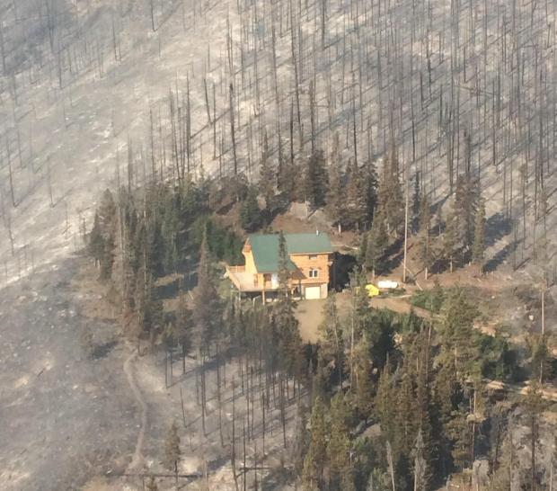
Beaver Creek fire saved structure
Beaver Creek Fire, Colorado, 2016. InciWeb.

The Federal Emergency Management Agency has recently awarded millions of dollars through their Disaster Mitigation Grant program.

Boulder County, Colorado

Boulder County will receive a $1.2 million Pre-Disaster Mitigation Grant for two wildfire mitigation actions. The first is to create defensible space for approximately 500 properties. The second is hazardous fuels reduction in an area of about 160 acres that will provide further protection on 27 properties where defensible space creation was previously completed.

Homeowner efforts to create defensible space will not just be a one-time effort. They will join the county’s wildfire mitigation program, Wildfire Partners, to support continued maintenance of defensible space over the long-term and conduct comprehensive mitigation efforts to effectively reduce wildfire risk in a community that has been severely affected by wildfire.

FEMA is providing 75 percent of the project costs, a total of $1,215,630. Funding is provided through FEMA’s Pre-Disaster Mitigation Grant Program, which is designed to assist states, U.S. territories, federally-recognized tribes, and local communities in implementing a sustained pre-disaster natural hazard mitigation program. The goal is to reduce overall risk to the population and structures from future hazard events, while also reducing reliance on federal funding in future disasters.

Ashland, Oregon

The city of Ashland, Oregon will receive a $3 million Pre-Disaster Mitigation Grant to create wildfire defensible space around 1,100 homes and to replace 23 wood shake roofs with ignition-resistant roof material.

The City of Ashland in Oregon’s Jackson County is in a high wildfire risk zone. In the fall of 2020, neighboring communities of Talent and Phoenix were devastated by the Almeda Fire, which burned 2,977 acres and destroyed over 2,300 structures.

This mitigation project will help protect structures from wildfires and will help homes in the Ashland area comply with recommended local best practices for wildfire risk reduction. Replacing wood shake roofs and providing defensible space to structures reduces the risk of wildfire spread and diminishes the likelihood of wildfires starting from embers. Once these highly flammable roofs are replaced, these types of roofs will no longer be allowed in Ashland.

The City is contributing a $1 million cost-share, making the total value of this grant $4 million.

The project includes hiring a project manager, preliminary assessments of identified homes, surveys for vegetation removal, scheduling and training of pre-approved contractors, removal of vegetation, and reconstruction of roofs.

Rolling Hills, California

A $1.1 million grant is going to the Los Angeles community of Rolling Hills. The funds will replace overhead power lines and poles with nearly 2,000 feet of underground cables and relocate transformers to an area with less wildfire risk. The Los Angeles Fire Department identified the area as a Very High Fire Hazard Severity Zone, the highest designation with the greatest fire risk.

The $1.5 million project includes a $1.1 million grant from FEMA’s Hazard Mitigation Grant Program (HMGP), with the remaining $381,000 from non-federal sources.


Our take

As we wrote last September, grants to mitigate wildfire risk and improve community resiliency is a worthwhile investment:

Provide grants to homeowners that are in areas with high risk from wildland fires. Pay a portion of the costs of improvements or retrofits to structures and the nearby vegetation to make the property more fire resistant. This could include the cost of removing some of the trees in order to have the crowns at least 18 feet apart if they are within 30 feet of the structures — many homeowners can’t afford the cost of complete tree removal.

But the limited amount of Federal taxpayer funds available must be distributed where they can get the most bang for the buck and assist a significant number of residents.

Rolling Hills is a gated community of private roads on a hill overlooking the Pacific Ocean in Los Angeles where the median household income is $239,375 and the poverty rate is 1.6%. The project will reduce wildfire ignitions along 2,000 feet of power lines.

Boulder County has a median household income of $83,019 and a poverty rate of 10.7%. Their grant will mitigate hazards on 527 properties.

Ashland, Oregan has a median income of $56,315 and a poverty rate of 18.4%. More than 1,100 homes will be affected by the project.

Putting 2,000 feet of power lines underground in Rolling Hills could reduce the chance of poorly designed or maintained electrical lines starting fires. But a case could be made that the project should not rank high enough nationwide to prevent other grants from being approved that would have a much greater beneficial effect on larger numbers of people with far less disposable income. In this affluent Los Angeles community improvements on the electrical lines, in this case, should be funded by the Los Angeles Department of Water and Power.

There is probably more than one resident in Rolling Hills who could write a check for the project then go into the backyard and finish their game of tennis.


FEMA has more information about the Pre-Disaster Mitigation and Hazard Mitigation Grant programs.

Studying a wildland urban interface maintained by Native Americans from 1100 to 1650

Ancestors of the Jemez Pueblo used fire 27 different ways

Conceptual map of landscape zones Hemish people
Figure 2 from the publication. Conceptual map of landscape zones and 27 fire and wood uses for Hemish people.

A paper being published this week looks at an area in Northern New Mexico that was populated by Native Americans living within a wildland urban interface (WUI) that was sustainable from approximately 1100 to 1650.

Below are excepts from the publication.


Researchers combined ethnography, archaeology, paleoecology, and ecological modeling to infer intensive wood and fire use by Native American ancestors of Jemez Pueblo and the consequences on fire size and intensity. Initial settlement of northern New Mexico by Jemez farmers increased fire activity within an already dynamic landscape that experienced frequent fires. Wood harvesting for domestic fuel and architectural uses and abundant, small, patchy fires created a landscape that burned often but only rarely burned extensively.

Depopulation of the forested landscape due to Spanish colonial impacts resulted in a rebound of fuels accompanied by the return of widely spreading, frequent surface fires. The sequence of more than 500 years of perennial small fires and wood collecting followed by frequent “free-range” wildland surface fires made the landscape resistant to extreme fire behavior, even when climate was conducive and surface fires were large. The ancient Jemez WUI offers an alternative model for fire management in modern WUI in the western United States, and possibly other settings where local management of woody fuels through use (domestic wood collecting) coupled with small prescribed fires may make these communities both self-reliant and more resilient to wildfire hazards.

Policy implications

The Jemez ancient wildland urban interface (WUI) obviously contrasts with modern WUI in the American West in ways that make the ancient WUI an imperfect analog for modern conditions. The economic, technological, and political differences are irreconcilable but they do not obviate the relevance of the ancient WUI for modern problems. The cultural contrasts between ancient and modern WUI highlight opportunities to cultivate more resilient communities by supporting particular cultural values.

Two of the important characteristics of the Jemez ancient WUI are: 1) That it was a working landscape, in which properties of the fire regime were shaped by wood, land, and fire use that supported the livelihoods of the residents; and 2) that there was much greater acceptance of the positive benefits of fire and smoke.

We emphasize that these are malleable cultural features, because reshaping western United States culture by learning from indigenous cultural values may be critical for building adaptive and transformative resilience in modern communities. Learning to value the positive benefits of fire and smoke and to tolerate their presence will undoubtedly be critical to WUI fire adaptations.

Furthermore, the ancient WUI highlights two key processes that may make modern WUI more resistant to extreme fires: 1) Intensive wood collecting and thinning, particularly in close proximity to settlements; and 2) using many small, patchy fires annually (approximately 100 ha) rather than using larger burn patches (thousands of hectares) to restore fire and reduce fuel hazards, particularly closer to settlements.

Many WUI communities—especially rural and Indigenous communities—rely on domestic biomass burning for heat during the winter. Public/private–tribal partnerships to thin small diameter trees and collect downed and dead fuel for domestic use could have dual benefits for the community by meeting energy needs and reducing fuel loads. Tribal communities that have deep histories in a particular forested landscape may be ideal partners for supervising such a program. Lessons from the Jemez ancient WUI also suggest that federal and state programs to support prescribed burning by Native American tribes, WUI municipalities, and private land owners would provide equal benefit to modern communities.

It is imperative that we understand the properties and dynamics of past human–natural systems that offer lessons for contemporary communities . The Jemez ancient WUI is one of many such settings where centuries of sustainable human–fire interaction offer tangible lessons for adapting to wildfire for contemporary communities.


Authors of the paper: Christopher I. Roos, Thomas W. Swetnam, T. J. Ferguson, Matthew J. Liebmann, Rachel A. Loehman, John R. Welch, Ellis Q. Margolis, Christopher H. Guiterman, William C. Hockaday, Michael J. Aiuvalasit, Jenna Battillo, Joshua Farella, and Christopher A. Kiahtipes.

Measuring live fuel moisture with satellites

Satellite Fuel Moisture map
Estimated Live Fuel Moisture Content for the first 15-day periods of June, August, and October of 2019. Grey pixels indicate LFMC estimates were unavailable. LFMC estimates were unavailable when Sentinel-1 or Landsat-8 cloud- and snow-free surface reflectance were unavailable in the 3 months prior to time of estimation or when the land cover class of a pixel was absent from the training data.

BY JOSIE GARTHWAITE

As California and the American West head into fire season amid the coronavirus pandemic, scientists are harnessing artificial intelligence and new satellite data to help predict blazes across the region.

Anticipating where a fire is likely to ignite and how it might spread requires information about how much burnable plant material exists on the landscape and its dryness. Yet this information is surprisingly difficult to gather at the scale and speed necessary to aid wildfire management.

Now, a team of experts in hydrology, remote sensing and environmental engineering have developed a deep-learning model that maps fuel moisture levels in fine detail across 12 western states, from Colorado, Montana, Texas and Wyoming to the Pacific Coast.

The researchers describe their technique in the August 2020 issue of Remote Sensing of Environment. According to the senior author of the paper, Stanford University ecohydrologist Alexandra Konings, the new dataset produced by the model could “massively improve fire studies.”

According to the paper’s lead author, Krishna Rao, a PhD student in Earth system science at Stanford, the model needs more testing to figure into fire management decisions that put lives and homes on the line. But it’s already illuminating previously invisible patterns. Just being able to see forest dryness unfold pixel by pixel over time, he said, can help reveal areas at greatest risk and “chart out candidate locations for prescribed burns.”

The work comes at a time of growing urgency for this kind of insight, as climate change extends and intensifies the wildfire season – and as the ongoing COVID-19 pandemic complicates efforts to prevent large fires through controlled burns, prepare for mass evacuations and mobilize first responders.

Getting a read on parched landscapes
Fire agencies today typically gauge the amount of dried-out, flammable vegetation in an area based on samples from a small number of trees. Researchers chop and weigh tree branches, dry them out in an oven and then weigh them again. “You look at how much mass was lost in the oven, and that’s all the water that was in there,” said Konings, an assistant professor of Earth system science in Stanford’s School of Earth, Energy & Environmental Sciences (Stanford Earth). “That’s obviously really laborious, and you can only do that in a couple of different places, for only some of the species in a landscape.”

The U.S. Forest Service painstakingly collects this plant water content data at hundreds of sites nationwide and adds them to the National Fuel Moisture Database, which has amassed some 200,000 such measurements since the 1970s. Known as live fuel moisture content, the metric is well established as a factor that influences wildfire risk. Yet little is known about how it varies over time from one plant to another – or from one ecosystem to another.

For decades, scientists have estimated fuel moisture content indirectly, from informed but unproven guesses about relationships between temperature, precipitation, water in dead plants and the dryness of living ones. According to Rao, “Now, we are in a position where we can go back and test what we’ve been assuming for so long – the link between weather and live fuel moisture – in different ecosystems of the western United States.”

AI with a human assist
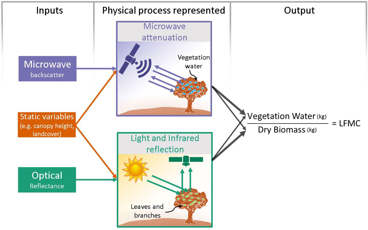
The new model uses what’s called a recurrent neural network, an artificial intelligence system that can learn to recognize patterns in vast mountains of data. The scientists trained their model using field data from the National Fuel Moisture Database, then put it to work estimating fuel moisture from two types of measurements collected by spaceborne sensors. One involves measurements of visible light bouncing off Earth. The other, known as synthetic aperture radar (SAR), measures the return of microwave radar signals, which can penetrate through leafy branches all the way to the ground surface.

Satellite Fuel Moisture diagram
Conceptual model linking Live Fuel Moisture Content to inputs variables. The physical process representation is for illustrative purposes only; the empirical model estimates LFMC directly from the inputs. Thicker arrows from the physical process representation to the output represent relatively greater sensitivity. For example, microwave backscatter, due to microwave attenuation, has relatively higher sensitivity to vegetation water as compared to optical and IR reflection.

“One of our big breakthroughs was to look at a newer set of satellites that are using much longer wavelengths, which allows the observations to be sensitive to water much deeper into the forest canopy and be directly representative of the fuel moisture content,” said Konings, who is also a center fellow, by courtesy, at Stanford Woods Institute for the Environment.

To train and validate the model, the researchers fed it three years of data for 239 sites across the American west starting in 2015, when SAR data from the European Space Agency’s Sentinel-1 satellites became available. They checked its fuel moisture predictions in six common types of land cover, including broadleaf deciduous forests, needleleaf evergreen forests, shrublands, grasslands and sparse vegetation, and found they were most accurate – meaning the AI predictions most closely matched field measurements in the National Fuel Moisture Database – in shrublands.

Rich with aromatic herbs like rosemary and oregano, and often marked by short trees and steep, rocky slopes, shrublands occupy as much as 45 percent of the American West. They’re not only the region’s biggest ecosystem, Rao said, “they are also extremely susceptible to frequent fires since they grow back rapidly.” In California, fires whipped to enormous size by Santa Ana winds burn in a type of shrubland known as chaparral. “This has led fire agencies to monitor them intensively,” he said.

The model’s estimates feed into an interactive map that fire agencies may eventually be able to use to identify patterns and prioritize control measures. For now, the map offers a dive through history, showing fuel moisture content from 2016 to 2019, but the same method could be used to display current estimates. “Creating these maps was the first step in understanding how this new fuel moisture data might affect fire risk and predictions,” Konings said. “Now we’re trying to really pin down the best ways to use it for improved fire prediction.”


Konings is also Assistant Professor, by courtesy, of Geophysics in Stanford’s School of Earth, Energy & Environmental Sciences. Co-author A. Park Williams is affiliated with Lamont-Doherty Earth Observatory at Columbia University. Co-author Jacqueline Fortin Flefil, MS ’18, is now an engineer at Xylem, Inc.

The research was supported by Amazon Web Services (AWS) Cloud Credits for Research, the NASA Earth and Space Science Fellowship, the UPS Endowment Fund at Stanford, the Stanford Woods Institute for the Environment, and the Zegar Family Foundation.

Federal wildfire policy and the responsibilities of community planners and homeowners

If communities are to become truly fire-adapted, suppression efforts must be complemented with other preventative mitigation measures.

fire Whiskeytown National Recreation Area, California, 2009
Whiskeytown National Recreation Area, California, 2009. NPS photo.

This is an excerpt from an article at Headwaters Economics written by Kimiko Barrett titled “Federal wildfire policy and the legacy of suppression.” Most of the original piece lays out the history of wildfires and the related government policies. Below is the last part that covers the 2018 wildfire budgeting fix and the responsibilities of individual homeowners and the government. It is used here with permission.


…To end the cycle of deficit spending and wildfire borrowing, a massive appropriations bill was passed in 2018—which was also the worst wildfire season in decades and saw the death of over 80 civilians from the Camp Fire in Paradise, California. Captured as a provision in the omnibus bill, the “wildfire fix” treats wildfires similar to other natural disasters and establishes a reserve fund to use during extreme wildfire seasons. Starting in 2020, a wildfire disaster fund of $2.25 billion was created and will be gradually increased over the following 10 years. When the Forest Service’s suppression costs exceed annual appropriations, based on FY2015 levels, funds can be withdrawn from the reserve budget rather than borrowing from nonfire programs. The spending bill also increases funding for fuels reduction projects, grants environmental review exemptions for projects meeting categorical exclusion, extends land stewardship programs, and initiates the process of wildfire risk mapping.

The 2018 wildfire fix was widely applauded by nongovernmental organizations, industries, and policymakers for stabilizing agency budgets and ending wildfire borrowing. While the new legislation provides the Forest Service with the financial flexibility to accommodate soaring suppression costs, it reaffirms the government’s prioritization of fire control and the protection of people and homes at any price.

From Federal Policy to Local Action

Continued reliability on wildfire suppression shifts responsibility for home protection from the individual homeowner and local jurisdictions to the federal government. Yet local communities bear the economic, environmental, and social costs of wildfire disasters, and some of the most essential mitigation actions need to be taken at the scale of individual communities and homes.

At the neighborhood and community scale, land use planning provides a suite of mitigation measures. Land use planning tools, such as regulations, zoning, and building codes can influence how, where, and under what conditions homes can be built in high wildfire hazard areas. Through the proactive lens of planning and anticipating wildfires, people and communities can learn to live with wildfire on the landscape.

By performing basic home mitigation measures, such as trimming trees, managing vegetation, safely storing flammable materials away from the home, and reducing other vulnerabilities within the home ignition zone (HIZ), a home’s chances of surviving a wildfire greatly increase. Constructing a home using wildfire-resistant building materials can also contribute to a home’s survivability during a wildfire.

Conclusion

Large and extreme wildfires are inevitable and efforts to extinguish them are costly, dangerous, and unrealistic. The federal government’s ongoing commitment to wildfire suppression is rooted in early 20th century policies that haven’t kept pace with current science and knowledge on wildfire behavior. If communities are to become truly fire-adapted, suppression efforts must be complemented with other preventative mitigation measures.

This post is based on an article originally published in the Idaho Law Review, Volume 55(1).

Kimiko Barrett has a deep interest in rural landscapes and the people who live there. Born and raised in Bozeman, Montana, she appreciates the outdoors and the intimate connections people have with the land. After obtaining undergraduate degrees in Political Science and Japanese, Kimi completed a Master’s in Geography from Montana State University and a Ph.D. in Forestry from University of Montana. Her doctorate research focused on climate change impacts in high mountain ecosystems and took her to remote places in the western Himalayas.

Researchers say thinning forests or prescribed fire before drought reduced tree loss

Treated areas had 15 percent less mortality

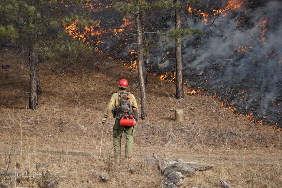
Whaley prescribed fire
A firefighter monitors the Whaley prescribed fire in the Black Hills National Forest, January 13, 2016. Photo by Bill Gabbert.

From the University of California – Davis

Thinning forests and conducting prescribed burns may help preserve trees in future droughts and bark beetle epidemics expected under climate change, suggests a study from the University of California, Davis.

The study, published in the journal Ecological Applications, found that thinning and prescribed fire treatments reduced the number of trees that died during the bark beetle epidemic and drought that killed more than 129 million trees across the Sierra Nevada between 2012-2016.

“By thinning forests, we can reduce water stress and make forests more resilient to drought and climate change,” said the study’s lead author, Christina Restaino, a postdoctoral scholar at UC Davis in the Department of Environmental Science and Policy when the study was conducted.

The study also indicated that current rates of treatment are not sufficient to reduce the impacts of hotter droughts and large-scale bark beetle outbreaks. Expanding the use of managed fire under moderate fire-weather conditions, along with strategic thinning and prescribed burn treatments, may increase resilience across the forest, the researchers said.

“There are currently too many straws in the cup,” said Restiano. “Denser forests use more water. We’re learning that fuel treatments used to reduce fire risk have multiple benefits. Forests that are more open and less dense are stronger in the face of insect outbreaks, too.”

TREATMENT HELPS

For the study, researchers collected plot data in 2017 at 10 pairs of treated and untreated sites stretching from Eldorado National Forest to Sierra National Forest in the central and southern Sierra Nevada. They compared the effects of pre-drought thinning and prescribed burn treatments at those sites for four major species: ponderosa pine, sugar pine, white fir and incense cedar.

Treated areas generally had lower stand densities, bigger tree diameters and more pines, which were historically dominant.

Ponderosa pine experienced the greatest mortality of the species studied (40 percent) during the drought and beetle outbreak. But its mortality was significantly lower in treated stands. In untreated areas, the chance any one tree would die was about 45 percent. In treated stands, that chance went down to 30 percent.

Both ponderosa and sugar pine trees died more in places where their diameters were larger, suggesting insects may prefer larger trees, especially when the trees are stressed. The study demonstrates that removing smaller trees through thinning and prescribed burns can help reduce the stress in larger trees, which restoration efforts prioritize.

BE PROACTIVE

“It’s important to be proactive,” said coauthor Derek Young, a postdoctoral researcher in the UC Davis Department of Plant Sciences. “This is not the kind of thing to start only when the drought starts. It has to be done beforehand.”

The study also notes that forest managers in the Sierra Nevada might consider cultivating a broader variety of species to buffer against insects and disease, as well as shifting from pines to more resilient hardwood species, like oaks and madrone — a transition underway in other semi-arid and Mediterranean climates.

Funding was provided for the study by the USDA Forest Service Forest Health Protection program, the USDA Forest Service Pacific Southwest Region, and the US Geological Survey Southwest Climate Science Center.


Ecological Applications, which published the study paid for by the US Forest Service and the USGS, is charging taxpayers $49 if they want a copy.

Statements from five presidential candidates about wildland fire

They were asked about how to break the cycle of more severe weather, homes in fire-prone areas, and fire suppression that puts forests at greater risk for more catastrophic fires in the future

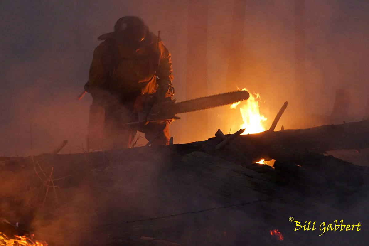
North Pole Fire South Dakota
Chain saw operator on the North Pole Fire west of Custer, SD March 10, 2015. Photo by Bill Gabbert.

In an effort to provide for our readers information about positions the presidential candidates have taken on wildland fire issues, today we have the second article in the series. Earlier this month we searched the websites of the candidates and were able to find the issue addressed by only one, Mike Bloomberg, which we put in a February 15 article.

We wrote:

To be clear, Wildfire Today is not endorsing any candidates, but in an effort to inform voters we will be happy to write about all substantive written positions related to fire that are taken by presidential Candidates as long as they have more than 2 percent in a reliable nationwide poll on the election such as this one at fivethirtyeight.

We have already covered the incumbent’s plan, the proposed budget for next fiscal year.

After seeing that article one of our readers, Su Britting, informed us that she had seen a piece in the Desert Sun featuring the candidates’ responses to a fire-related question posed by a Research Scientist for the U.S. Forest Service who also teaches at the University of California at Davis.

Below is an excerpt from the article, used here with permission from Executive Editor Julie Makinen. The only part not included are a few introductory paragraphs written by the reporter, Sam Metz. The candidates’ statements in the Desert Sun article are included in their entirety.


…We enlisted Professor Malcolm North, a fire ecologist with the U.S. Forest Service who also teaches at UC Davis, to ask the candidates running in the Democratic Party’s presidential primary a question about wildfire policy.

North wanted to see how candidates would balance California’s need for more housing with the hazards of building in wildfire-prone regions and how they’d address concerns surrounding fire suppression and its potential to exacerbate the problem. Each candidate was given the same set of questions to answer within a specific timeframe.  Some campaigns responded in the third person (e.g. “Senator Klobuchar believes …”) while other candidates responded themselves (e.g. “As president, I’ll invest …”). Candidates that are not featured did not provide a response.

Like most of the western United States, California’s wildfires are becoming more destructive with more severe weather, unchecked home building in fire-prone areas, and fire suppression that puts forests at greater risk for larger, more catastrophic fires in the future. As president, how would you do to help break this cycle for the sake of both people and ecosystems? — Malcolm North, Research Scientist, U.S. Forest Service, Mammoth Lakes, Calif.

Elizabeth Warren: Climate change is an existential threat to all life on this planet — and Californians are already seeing the dangers of climate change first hand.  Elizabeth Warren is an original co-sponsor of the Green New Deal resolution and has more than 10 climate plans that detail how a Warren administration will achieve domestic net zero emissions by 2030.

Wildfires pose an especially serious threat to low-income communities, people with disabilities, and seniors. That’s why Elizabeth has committed to:

  • Improving fire mapping and prevention by investing in advanced modeling with a focus on helping the most vulnerable — incorporating not only fire vulnerability but community demographics.
  • Prioritize these data to invest in land management, particularly near the most vulnerable communities, supporting forest restoration, lowering fire risk, and creating jobs all at once.
  • Invest in microgrid technology, so that we can de-energize high-risk areas when required without impacting the larger community’s energy supply.
  • Collaborate with Tribal governments on land management practices to reduce wildfires, including by incorporating traditional ecological practices and exploring co-management and the return of public resources to indigenous protection wherever possible.

She’s also committed to prioritizing at-risk populations in disaster planning and response and strengthening rules to require disaster response plans to uphold the rights of vulnerable populations. A Warren administration will center a right to return for individuals who have been displaced during a disaster and while relocation should be a last resort, when it occurs, she is committed to improving living standards and keeping communities together whenever possible.

Pete Buttigieg: California’s devastating wildfires are one example of the accelerated impacts of climate change. This is one of the most pressing security challenges of our era and it will absolutely be a top priority under my administration. To stem the impacts of climate change my administration will get our country to net-zero emissions no later than 2050, by implementing a bold and achievable Green New Deal. We will enact a price on carbon and use the revenue to send rebates directly to Americans’ pockets. We will also quadruple federal clean energy R&D funding to invest more than $200 billion in developing new technologies as well as create three investment funds to spur clean technology development and fund locally-led clean energy projects, particularly in disadvantaged communities.

Promoting resilient infrastructure is crucial to preparing communities against climate change. The American Clean Energy Bank and Regional Resilience Hubs that I am proposing will finance local investments in resilient infrastructure. My administration will develop federal guidelines for investments in and implementation of new approaches, including nature-based solutions, that make our natural resources and communities safer and more resilient. We will also establish a National Catastrophic Extreme Weather Insurance (CEWI) program to provide stability to individuals and communities who experience the major disruptions caused by climate change and other natural risks such as earthquakes. We will build a resilient nation that can stand up to the extreme weather and sea level rise we are already facing, and lead the world in bringing our international partners and local leaders together to solve this crisis.

Tom Steyer: I began this campaign because despite several Democratic candidates talking about the climate crisis, the seriousness of the threat was not getting the attention it demanded.  I am the only candidate who will make addressing climate change my number one priority as President of the United States. Climate change doesn’t just represent a serious threat — it is also a great opportunity to build a sustainable American infrastructure and an economy that restores prosperity to all Americans, not just the wealthy. In order to break the cycle of the catastrophic effects of climate change, we need to build resilient infrastructure and a renewable economy. We also need to invest in individual ecosystems (forests, lakes, oceans) in the context of climate change. This will mean undoing the negligence of the Trump administration’s policies and creating collaboration between the states and the federal government to address the problems of designing, building and maintaining climate-resilient communities.

As part of my Justice Centered Climate Plan, I will invest nearly $500 billion in the upkeep and protection of our watersheds, wetlands, national parks, and forests — and this includes fire management as well as protecting our clean drinking water. Because while some of the impacts of climate change are already here, there are levelheaded preventative measures we can take to protect ourselves and our forests from the worst dangers. My plan puts $555 billion into developing climate-smart communities and housing and an additional $755 billion into adaptation, resilience, and green infrastructure. This will ensure that the people who are displaced from fires and flooding have affordable places to live with access to green space. And it will also ensure that they have good-paying jobs building our new climate-resilient infrastructure, protecting our lands and waters, and serving communities hit by the climate crisis as long-term disaster recovery workers.

Bernie Sanders: We’re already seeing the devastating effects of climate change. In California, 15 of the 20 largest fires in the state’s history have occurred since 2000. We must invest now in mitigating these more frequent and severe wildfires, making our infrastructure more resilient, and preparing for disaster response. We must change our framework of fire suppression and forest management to take the whole local ecosystem into account, including the rural communities who are most vulnerable.

In California, developers are building houses in fire hazard zones, a move partially driven by the housing shortage. Bernie is committed to fully closing the 7.4 million unit shortage of affordable housing to guarantee housing to all as a right. We will work to ensure housing growth is climate-resilient, with experts and impacted communities included every step of the way.

We’ll expand the wildfire restoration and disaster preparedness workforce. We’ll increase federal funding for firefighting by $18 billion to deal with the increased severity and frequency of wildfires. Furthermore, we must facilitate community evacuation plans that include people experiencing homelessness, and increase social cohesion for rapid and resilient disaster recovery to avoid the use of martial law and increased policing in disaster response.

We’ll also amend the Stafford Act to ensure that FEMA ensures that recovery and rebuilding efforts make affected communities stronger than they were before the disaster so they are more resilient to the next disaster.

Michael Bloomberg: First and most importantly, we’ve got to act aggressively to curb the carbon pollution and climate change that is like pouring accelerant on our western forests, making fires bigger and more catastrophic — this will be a top priority for my presidency. In addition, we’ve got to transition from the old fire suppression approach to managing our forests to restore healthy ecosystems that are inherently more resilient to catastrophic fire.

I’m calling for an effort on the scale of FDR’s response to the Dust Bowl, making this a top priority for the Forest Service. I will direct them to work with other federal land agencies, states, tribes, and local communities to develop a far-reaching fire prevention and management plan for each state at risk, aiming to reduce the loss of lives and property by half within four years.