Man charged with setting fire in Southern Oregon that burned 15 properties

Michael Bakkela
Michael Bakkela. Photo: Jackson County Sheriff office.

A grand jury has indicted a 41-year old man for setting a fire in Phoenix, Oregon on September 8, the day the Almeda Drive Fire started near Ashland. Michael Jarrod Bakkela was arraigned on 2 counts of Arson in the First Degree, 15 counts of Criminal Mischief in the First Degree, 14 counts of Recklessly Endangering Another Person, and one count for Unlawful Possession of Methamphetamine.

Mr. Bakkela, who is being held on bail of $5 million, is accused of starting a fire that damaged 15 properties between Phoenix and Medford that contributed to the Almeda Drive Fire.

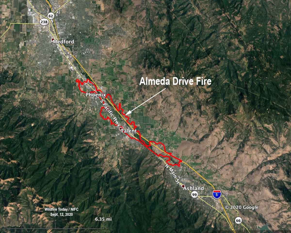
The Jackson County Sheriff’s Office announced September 15 that at least 2,357 structures were destroyed in the Almeda Drive Fire, which started north of Ashland and rapidly spread northwest through Talent, then Phoenix, and was finally stopped south of Medford.
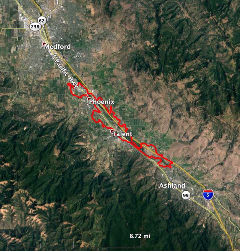
Almeda Drive Fire map
Map of the Almeda Drive Fire in Southern Oregon, September 10, 2020. Google/Wildfire Today/NIFC

The wording of the indictment implies that the fire allegedly started by Mr. Bakkela merged with the Almeda Drive Fire.

From Oregon Live:

According to the county Sheriff’s Office, residents in the 1100 block of Quail Lane called 911 at 5:09 p.m. Sept. 8 to report that a man, later identified as Bakkela, was lighting a fire near the railroad tracks behind their home. A deputy took Bakkela into custody a short time later.

Detectives suspect Bakkela drove into a gated area, parked a vehicle, started a fire and then fled north before he was stopped, according to the Sheriff’s Office.

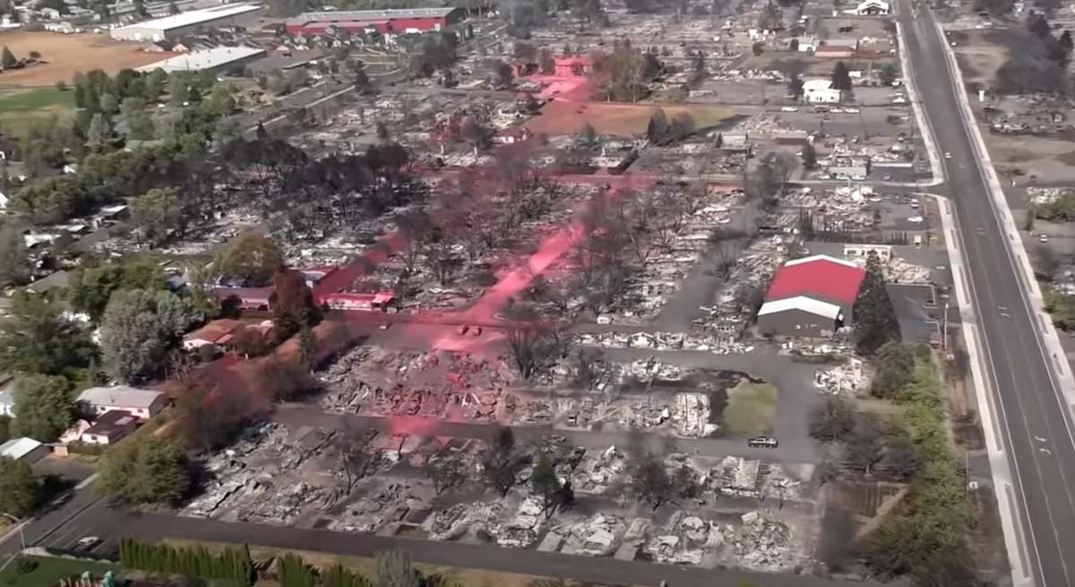
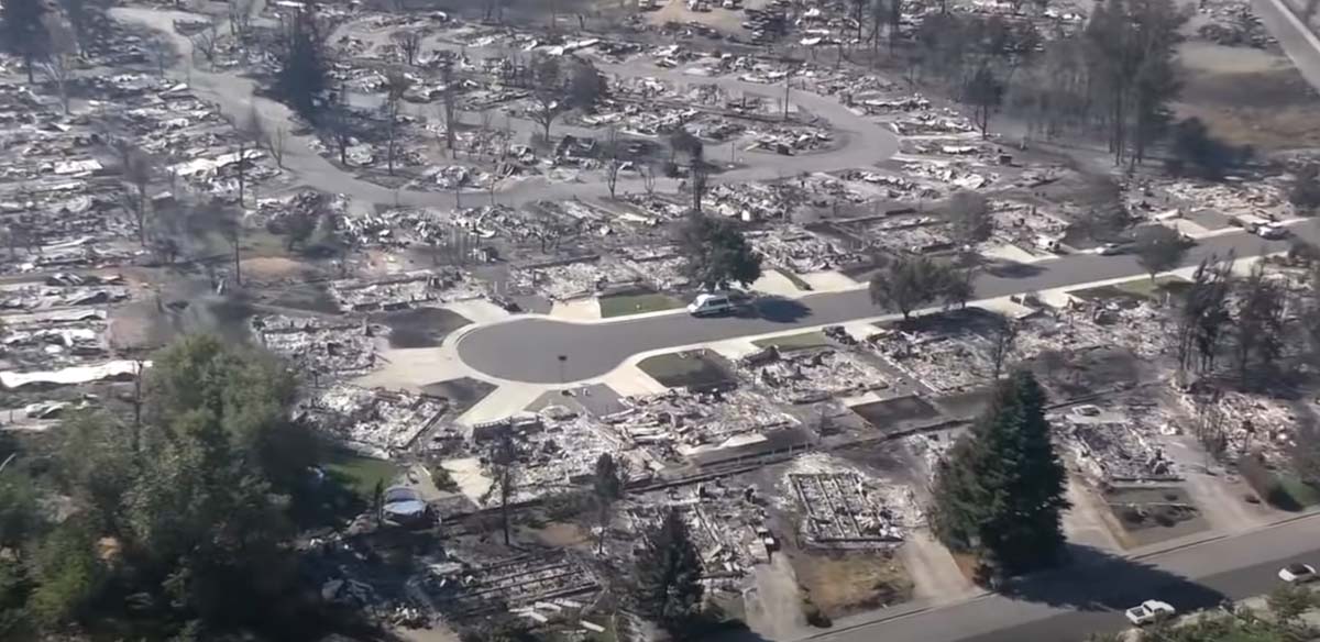
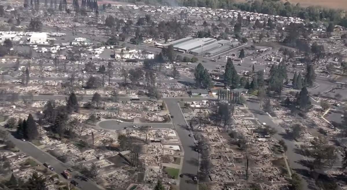
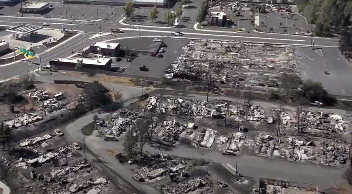
Video shows large number of structures burned during the Almeda Drive Fire in southern Oregon

It impacted the cities of Talent and Phoenix, September 8, 2020

structures burned Almeda Fire Phoenix Talent Oregon
Devastation from the Almeda Drive Fire in the area of Phoenix and Talent in southern Oregon. Screenshot from video shot by Jackson County on September 8, 2020.

The latest official estimate of the number of structures destroyed in the Almeda Drive Fire in southern Oregon on September 8 is 600 homes and 100 commercial buildings. A video appears to indicate that number is conservative.

(Update November 19, 2020: Jackson County estimates 2,357 residences were destroyed in the 3,200-acre fire.)

Authorities have confirmed two deaths. Since lightning and power lines can be ruled out, they have concluded it was human-caused. It is possible the number of fatalities could rise as searches are conducted. It was weeks before searches were concluded after the Camp Fire at Paradise, California. There will be lists of people that are unaccounted for, but many of them will be safe and having difficulty communicating with family and friends.

map Almeda Drive Fire
Map of the Almeda Drive Fire

The Oregonian reports officials are considering arson as a possible cause:

Authorities are investigating the Almeda fire as an arson after discovering human remains in Ashland, the city police chief said. The Jackson County’s Major Assault/Death Investigation Unit is investigating the nature of the death of the person found, according to Ashland Police Chief Tighe O’Meara.

“One thing I can say is that the rumor it was set by Antifa is 100% false information,” the police chief said by email. “We have some leads, and none of it points in that direction.”

structures burned Almeda Drive Fire Phoenix Talent Oregon
Devastation from the Almeda Drive Fire in the area of Phoenix and Talent in southern Oregon. Screenshot from video shot by Jackson County on September 8, 2020.

The FBI is asking the public to not waste the time of law enforcement with conspiracy theories and misinformation.

FBI information fires Oregon

To have been so destructive, it is a little surprising that the fire only burned 3,200 acres. The 40 to 45 mph wind on September 8 was from the southeast, which aligned with the Interstate 5 corridor as it burned like a blowtorch for 8 miles, starting north of Ashland and tearing through the cities of Talent and Phoenix. Photos of what remains of the area show retardant drops made by air tankers, a DC-10 and two MD-87s, but they were largely ineffective. This is no surprise, since a wind stronger than 15 or 20 mph can scatter the retardant off target, or if the wind is stronger and turbulent it can be unsafe to operate an aircraft flying low and slow.

The video shot by Jackson County authorities on September 8 is below. It begins near Ashland, then continues up the Interstate 5 corridor through Talent and Phoenix.

Below are more screenshots from the video.

Continue reading “Video shows large number of structures burned during the Almeda Drive Fire in southern Oregon”

Oregon fires have burned about a million acres

An Area Command Team has been mobilized to assist local units in the state

structures burned Almeda Fire Phoenix Talent Oregon
Devastation from the Almeda Drive Fire in the area of Phoenix and Talent in southern Oregon. Screenshot from video shot by Jackson County on September 8, 2020.

It could take some time to count all of the structures that have burned in western Oregon. What is known so far about the huge fires that have burned approximately a million acres in the state is the deaths of seven people have been documented according to state officials. Dozens more, they said, are unaccounted for, but many of those could be safe and are having difficulty communicating with friends and relatives.

The number of people that have evacuated has been fluctuating wildly. The Oregonian reported that the state in a news release Thursday night said an “estimated 500,000 Oregonians have been evacuated and that number continues to grow.” The half-million figure received widespread attention, but after an analysis by the newspaper determined that number could not be accurate, Gov. Kate Brown acknowledged Friday the true number to be far lower, about 40,000. She explained that the higher figure included everyone in some category of evacuation, including “Be Set,” and “Be Ready.”

Map heat wildfires western U.S.
Map of heat detected on wildfires in the western U.S. by satellites September 12, 2020.

The weather next week is expected to be cooler, with decreasing winds and a slight chance of rain on Tuesday and Thursday. This should slow the spread of the blazes and enable firefighters to shift from evacuations to constructing fireline on the perimeters. Up until now, a very, very small percentage of the edges of the fires have containment line.

Doug Grafe, chief of fire protection at the Oregon Department of Forestry, said eight of the large fires “will be on our landscape until the winter rains fall. Those fires represent close to 1 million acres … We will see smoke and we will have firefighters on those fires up until the heavy rains.”

Three Area Command Teams (ACT) were mobilized Thursday to assist local units in suppressing the fires in the western states. One of them, led by Area Commander Joe Stutler, will be coordinating the efforts in northwest Oregon. The other two will be California.

Typically an ACT is used to oversee the management of large incidents or those to which multiple Incident Management Teams have been assigned. They can take some of the workload off the local administrative unit when they have multiple incidents going at the same time. Your typical Forest or Park is not usually staffed to supervise two or more Incident Management Teams fighting fire in their area. An ACT can provide decision support to Multi-Agency Coordination Groups for allocating scarce resources and help mitigate the span of control for the local Agency Administrator. They also ensure that incidents are properly managed, coordinate team transitions, and evaluate Incident Management Teams.

structures burned Almeda Fire Phoenix Talent Oregon
Devastation from the Almeda Drive Fire in the area of Phoenix and Talent in southern Oregon. Screenshot from video shot by Jackson County on September 8, 2020.
Satellite photo smoke wildfires
Satellite photo showing smoke from wildfires at 5:17 p.m. PDT September 11, 2020.

Glendower Fire (aka Almeda Fire) burns toward Medford, Oregon

Multiple structures have burned

Updated September 9, 2020 | 9:04 a.m. PDT

Map Almeda Drive and South Obenchain Fires
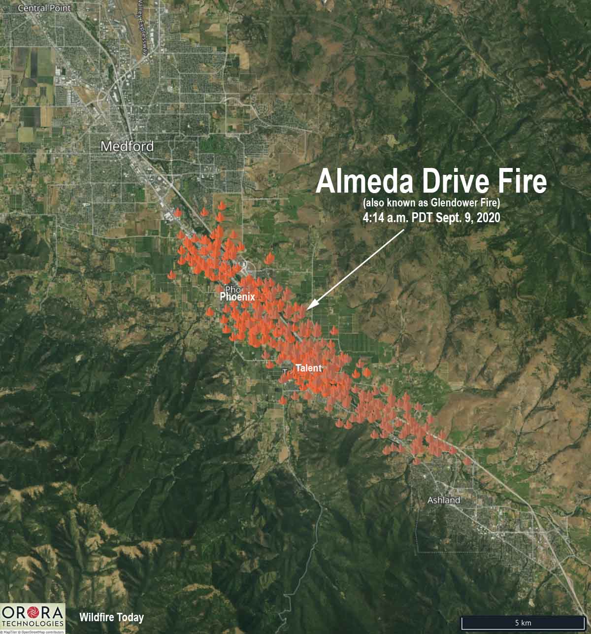
Map of the Almeda Drive and South Obenchain Fires at 4:14 a.m. PDT Sept 9, 2020.

A second fire in the Medford, Oregon area, the South Obenchain Fire north of the city, is prompting evacuations in the Shady Cove and Eagle Point areas. Evacuation maps are HERE.


September 9, 2020 | 8:33 a.m. PDT

Map of the Almeda Drive Fire
Map of the Almeda Drive Fire (Glendower Fire) at 4:14 a.m. PDT Sept. 9, 2020. The icons represent heat detected by satellites.

Here is an updated map of the Almeda Drive Fire (previously known as Glendower) showing heat detected by satellites at 4:14 a.m. PDT September 9, 2020. There has been much confusion about the name of the fire, but we have information from a fire official that the correct name is Almeda Drive.

The blaze started north of Ashland late Tuesday morning and roughly followed the Interstate 5 corridor as strong winds pushed it northwest. It burned through parts of Talent and by 4:14 a.m. Wednesday was at Phoenix.

Oregon Governor Kate Brown declared the Almeda Drive Fire a conflagration, a large fire which destroys a great deal of land or property. This will allow the state to send resources to assist local agencies.

At about 12:15 Wednesday morning the Oregon Department of Forestry estimated the blaze had burned 2,500 to 3,000 acres.

The Oregon State Fire Marshal incident management team arrived on scene at 1:50 a.m. Wednesday.

Evacuations are in effect for parts of Jackson County and the Medford area. Jackson County and MedfordAlert have evacuation information.


September 8, 2020  |  10:10 p.m. PDT

map Glendower Fire
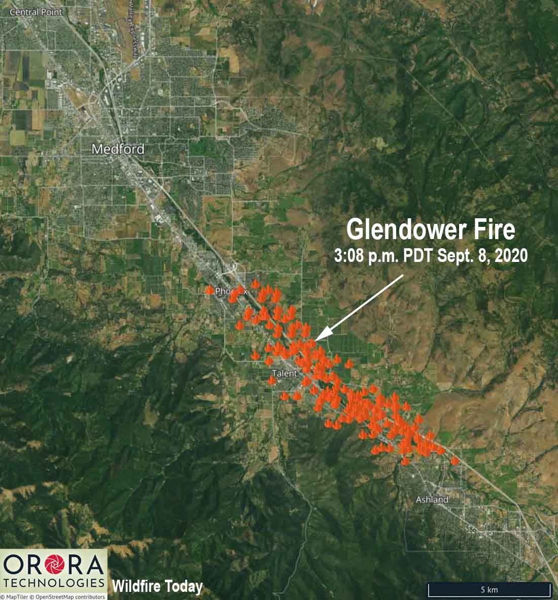
The icons represent heat detected on the Glendower Fire by satellites at 3:08 p.m. PDT September 8, 2020.

The Glendower Fire started north of Ashland, Oregon Tuesday morning then spread northwest along the Interstate 5 corridor (see the map above). At 5 p.m. it prompted evacuations of the entire city of Phoenix, Oregon. The incident is also known as the Almeda Fire.

By 8:45 p.m. evacuations were ordered in areas of Medford and multiple structures had burned. Jackson County and MedfordAlert have evacuation information. MedfordAlert said at 9:56 p.m. an evacuation center has been established at the Josephine County Fairgrounds on Redwood Avenue in Grants Pass. The Jackson County Expo is full.

Tuesday evening sections of Interstate 5 were closed north of the California/Oregon border. TripCheck has current status of the Interstate.

A Red Flag Warning is in effect for the Medford area Tuesday night and Wednesday. The wind direction in Medford will be variable Tuesday night at 3 to 5 mph with the humidity in the teens. On Wednesday the wind will increase at 11 a.m. from the southeast at 15 mph gusting to 23 while the humidity decreases to 7 percent. Wednesday’s high temperature will be 100.