Five of the most active wildfires in the South

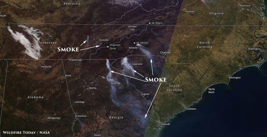
Above: Three fires were generating the smoke detected by a satellite on November 27: Rock Mountain, Camp Branch, and Pinnacle Mountain Fires.

The wildfire activity in the southern states has slowed a bit over the last few days. The day before Thanksgiving there were about 4,100 personnel assigned to fires in the area. By Saturday that number had decreased to 3,400.

The smoke generated by fires that has plagued residents for weeks has also diminished considerably. Today’s satellite photo, above, only shows three fires that are creating enough smoke to be seen from hundreds of miles overhead. These are the Rock Mountain (Georgia and North Carolina), Camp Branch (North Carolina), and Pinnacle Mountain Fires (South Carolina).

Just five fires in the Southern Geographic Area reported size increases on Saturday — a major change from recent weeks.

Rock Mountain Fire

The Rock Mountain Fire in Georgia and North Carolina grew by 2,578 acres in the last 48 hours and now has covered 20,647 acres, which is considered huge in this part of the country. It has spread to within 4 miles of Otto, NC and 4 miles of Dillard, GA. The fire was mapped Saturday by Colorado’s MultiMission Aircraft. Firefighters reported active surface spread in hardwood leaf litter in all directions, aspects and elevations on Saturday. Where it was not impacted by suppression it spread for half a mile. About 130 structures are threatened.

Camp Branch Fire

The 1,483-acre Camp Branch Fire is 9 miles west of Franklin, NC, an increase of 120 acres over the previous report. About 113 personnel are assigned to this fire which currently threatens 140 structures. On Saturday firefighters successfully conducted burnout operations on the northwest and southeast sides.

Pinnacle Mountain Fire

The Pinnacle Mountain Fire in Table Rock State Park added 217 acres Saturday to bring the total up to 9,147 acres. It is in northwest South Carolina 9 miles south of Brevard, North Carolina. The incident management team reports that 255 personnel are assigned and 1,133 structures are threatened. A burnout operation on Saturday brought the perimeter to the containment lines on the west and north sides of the fire.
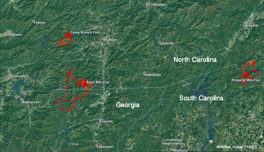
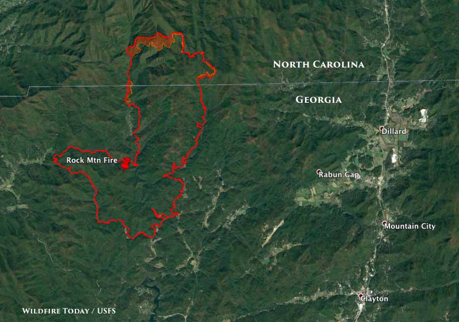
map Rock Mountain, Camp Branch, and Pinnacle Mountain Fires
Map showing the perimeters of the Rock Mountain, Camp Branch, and Pinnacle Mountain Fires.

OTHER FIRES

Clear Creek Fire

The Clear Creek Fire is 7 miles northwest of Marion, NC. I has burned 2,986 acres, an increase of 363 acres. About 352 structures are reported to be threatened. The fire is staffed by 489 personnel.

Mount Pleasant Fire

The Mount Pleasant Fire, 9 miles west of Buena Vista, Virginia has blackened 11,200 acres, an increase of 200. High humidity Friday night aided suppression efforts, but that was followed by strong winds on Saturday. Area road and trail closures, including part of the Appalachian Trail, are in effect. The fire has burned across the Appalachian Trail between Road 507 and Cow Camp Gap. The increase in acreage was the result of a large burnout operation on Saturday.

For the latest articles at Wildfire Today about how smoke from the wildfires is affecting various locations in the South, check out the articles tagged “smoke”.

Wildfire smoke decreases in Southeastern U.S. on Sunday, increases on Monday

Above: Satellite photo from Sunday afternoon, November 20, showing plumes of smoke.  

The amount of smoke created by wildfires in the southeastern United States decreased on Sunday. In satellite photos from last week smoke could be seen that covered large portions of South Carolina, Georgia, and North Carolina. However as you can see in the photo below, the smoke increased on Monday.

The amount and location of the smoke varies depending on the wind direction and the fire activity. It is difficult to predict more than a day in advance the quantity and location of smoke.

wildfire smoke map
Satellite photo from November 21 showing wildfire smoke. NASA

Below are maps predicting air quality information and the location of smoke for today, November 21.

Continue reading “Wildfire smoke decreases in Southeastern U.S. on Sunday, increases on Monday”

Progress made on some wildfires in the South, while others still grow

Chestnut Knob Fire
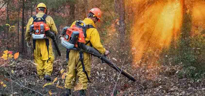
Firefighters with leaf blowers on the Chestnut Knob Fire. The fire is 6 miles south of Morganton, NC and at the last report grew by 9 acres. InciWeb.

While several large fires in the southern states are still actively spreading, firefighters have made progress on dozens of others.

On Monday the Southern Geographic Area reported 52 large uncontained fires, for a total of 133,146 acres. There were 185 new fires of all sizes for 1,477 acres; most of those were suppressed while still small. That was considered “moderate” initial attack activity.

Firefighting resources assigned in the South:

  • 78 aircraft
  • 83 hand crews
  • 1,011 pieces of equipment
  • 4,476 personnel
map wildfires south
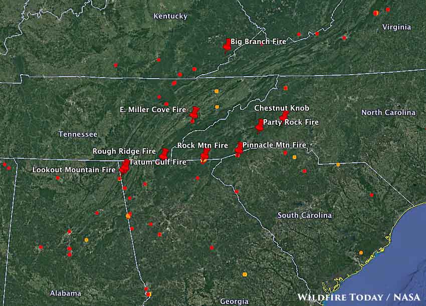
Map showing the location of some of the large fires in the southern states. The red dots represent heat detected by a satellite at 2:22 am November 21, 2016.

On Sunday evening four fires reported 24-hour growth of more than 100 acres:

Rock Mountain Fire

Map Rock Mountain Fire
Map of the perimeter of the Rock Mountain Fire at 6 p.m. ET November 20, 2016.

The Rock Mountain Fire that started about 10 miles northwest of Clayton Georgia has spread north into North Carolina. At the last report it had burned 11,287 acres, an increase of 862 acres. On Sunday it was very active, moving through the hardwood leaf litter in all directions at a rate of about one mile each day. Evacuations are still in place for Dream Catcher Cove north of Tate City, Georgia.

On Saturday strong winds pushed the blaze across the Appalachian Trail on the north end of the fire. Winds blowing leaves still falling from trees are creating problems for firefighters, covering existing firelines and causing some areas to re-burn.

East Miller Cove

The East Miller Cove Fire is just east of Walland, Tennessee, 16 miles south of Knoxville. On Sunday evening the incident management team reported it had burned 1,492 acres, an increase of 1,292 acres, threatening 100 structures north of Great Smoky Mountains National Park.

Big Branch

The Big Branch Fire is in southeast Kentucky three miles south of Roxana and five miles northeast of Cumberland. It has burned 625 acres, an increase of 175 acres.

Oakwood 1 Fire

This fire is in Arkansas, listed at 468 acres, an increase of 278. No other information is available.

Chestnut Knob Fire
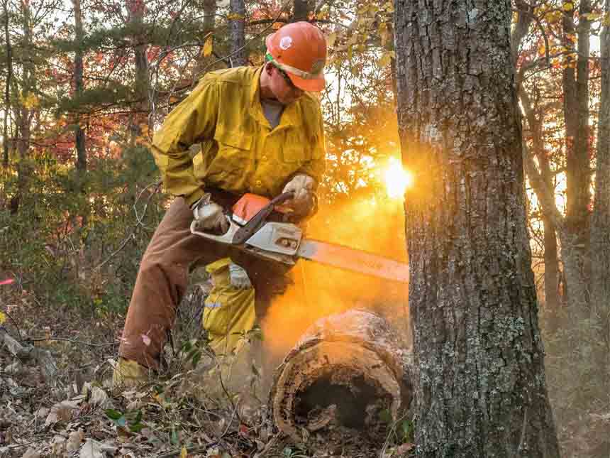
A firefighter on the Chestnut Knob Fire. InciWeb.

For the latest articles at Wildfire Today about how smoke from the wildfires is affecting various locations in the South, check out the articles tagged “smoke”.

North Carolina to receive the worst of the smoke on Friday

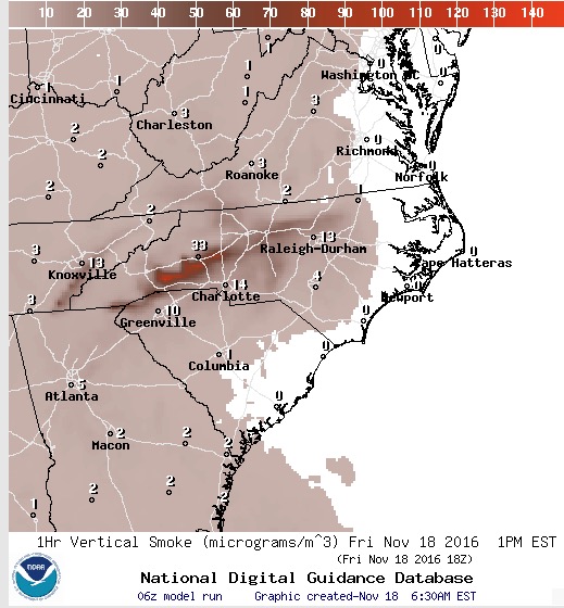
Above: Forecast for wildfire smoke at 6 p.m. ET November 18, 2016. Created at 1 a.m. ET November 18, 2016.

Most of the eastern one-third of the United States will be experiencing some degree of wildfire smoke on Friday. But by far the heaviest concentrations are being created by the wildfires in the South. The winds on Friday will cause the much of the smoke to pass through areas in western Tennessee, northern Georgia, and western North Carolina.

Forecast for wildfire smoke at 1 p.m. ET November 18, 2016, created at 6:30 a.m. ET November 18, 2016.

Continue reading “North Carolina to receive the worst of the smoke on Friday”

Wildfire smoke forecast for November 17, 2016

Above: In this satellite photo taken during the afternoon of November 16, smoke from wildfires is clearly visible in Georgia, North Carolina, and South Carolina.

Smoke from wildfires in the South continues to drift across Georgia, North Carolina, and South Carolina.

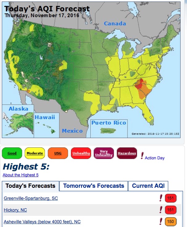
When the Air Quality Index (AQI) is between 101 and 150 due to smoke (the brown color in the AirNow map below) persons with heart and lung disease, older adults, and children are at greater risk. If the AQI is 151 to 200 (red in the map below) according to AirNow everyone may begin to experience health effects; members of sensitive groups may experience more serious health effects.

air quality index wildfire smoke

*

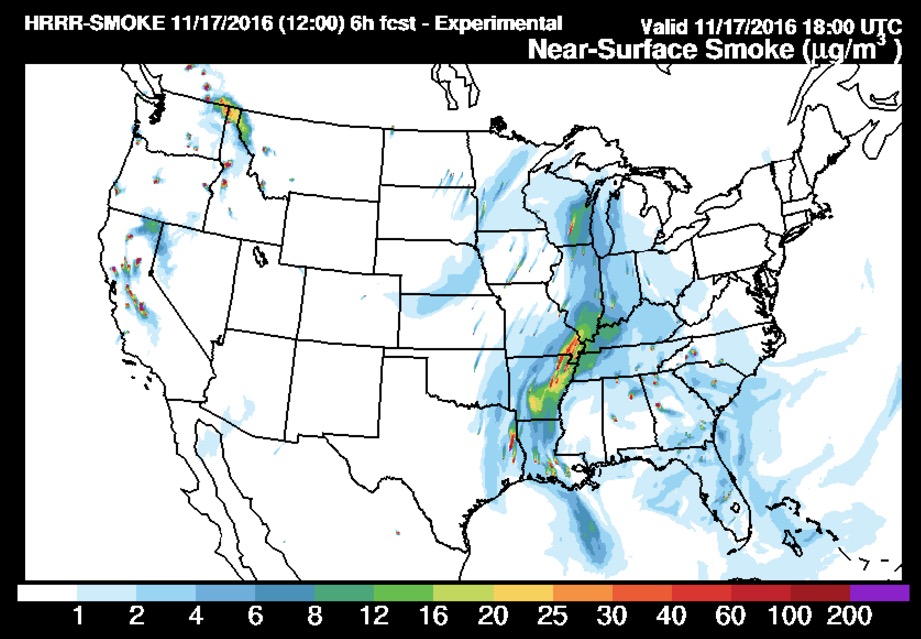
smoke forecast
Forecast for smoke from vegetation fires at 1 p.m. ET, November 17, 2016. In addition to the wildfires in Georgia, North Carolina, and South Carolina, it appears that smoke from agricultural burning and prescribed fires in Louisiana and Arkansas is having a significant effect on the air in those two states as well as the midwest. Created at 7 a.m. ET November 17. NOAA.

Many of our readers in the comments sections are asking about the smoke conditions in various locations. Keep in mind that the distribution of smoke is entirely dependant on the location of the fires and the wind direction. A large fire may affect areas in almost any direction if the wind blows it that way. For instance, it can be clear in Gatlinburg, TN one day and the next day it can be smoky.

It can be difficult to predict the impacts of smoke more than a day or two into the future. For one thing, exact wind direction and speed are hard to forecast accurately. And fire activity is even trickier to predict. New fires can break out, older ones can run out of fuel, and the effectiveness of firefighters can vary.

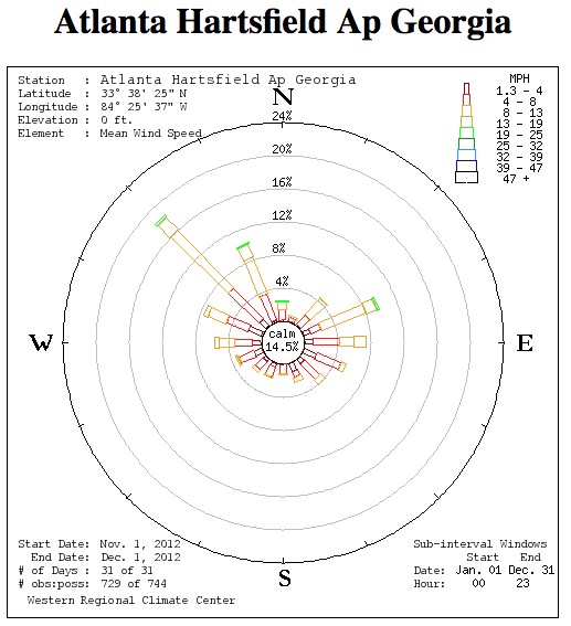
wind rose Atlanta
The “wind rose” for Atlanta, November, 2012. The bars point to the direction the wind was coming from. Western Regional Climate Center.

As you can see in the image above, at Atlanta the most common wind directions during November of 2012 were from the northwest and east, but other directions are also represented.

For the latest articles at Wildfire Today about how smoke from the wildfires is affecting various locations in the South, check out the articles tagged “smoke”.
Update on six wildfires in the South, November 16, 2016

Above: The map shows the locations of some of the larger wildfires currently burning in Tennessee, South Carolina, North Carolina, and Georgia.

Firefighters continue to battle dozens of fires in the southern United States while the residents in the area try to figure out how to live with the smoke.

Fire managers are hoping for a break in the weeks-long dry period, but through Friday at least they should expect more of the same. However there is a chance for rain on Saturday.

Here we will look at six of the larger fires in Georgia, North Carolina, and South Carolina.

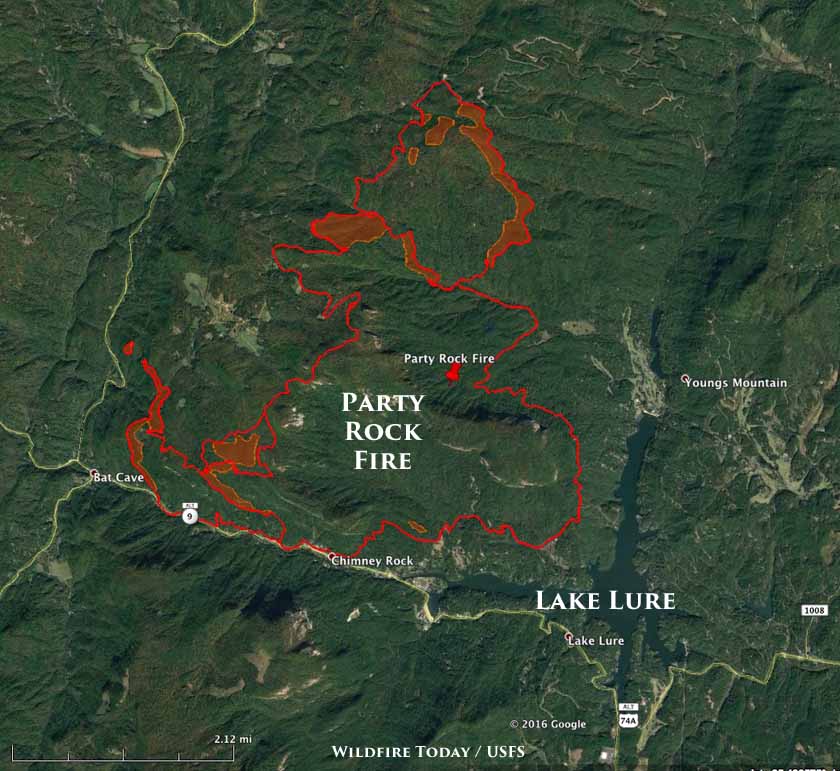
Party Rock Fire

map Party Rock Fire
Perimeter of the Party Rock Fire in North Carolina, 3 a.m. ET November 16, 2016.

The Party Rock Fire has been burning just north of Lake Lure, North Carolina since November 5. It has blackened 4,480 acres, an increase of 736 acres, and forced evacuations at Bat Cave and residences on the east side of Hwy 9. In recent days it has been most active on the north and southwest sides.

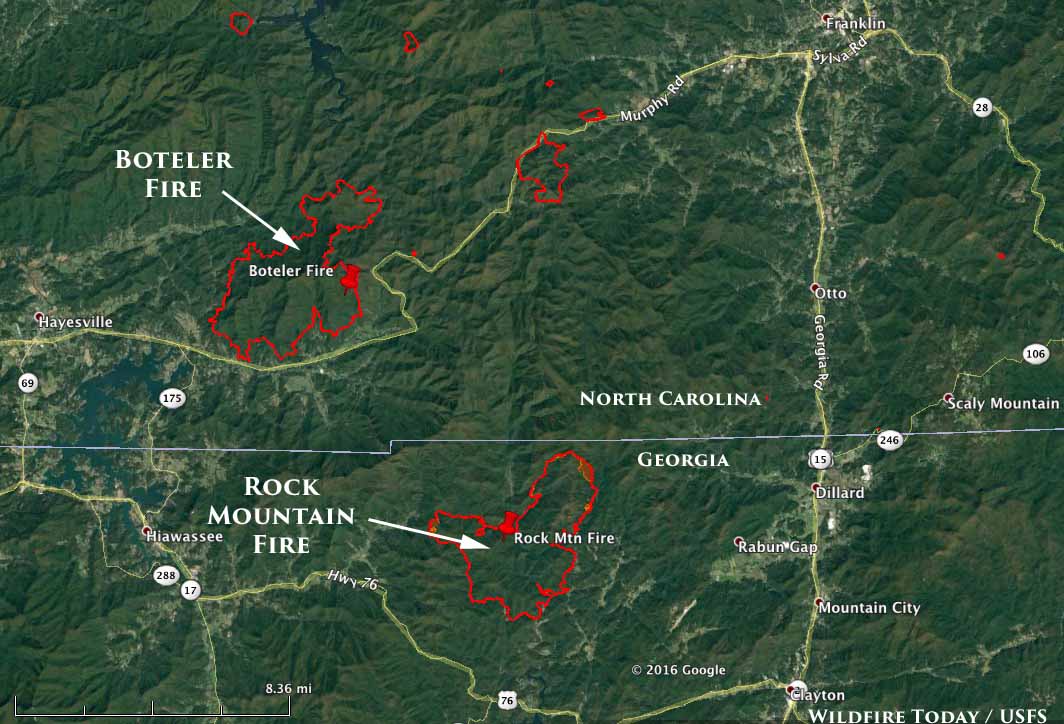
Rock Mountain Fire

map Rock Mountain Fire Boteler Fire
Perimeters of the Boteler Fire in NC at 11:45 p.m. ET November 15, 2016, and the Rock Mountain Fire in GA at 2 a.m. ET November 16, 2016.

The Rock Mountain Fire has burned 6,747 acres in the northeast corner of Georgia, an increase of 1,263 acres over the previous 24 hours primarily on the northeast and west sides. The Type 1 Incident Management Team reports that 75 structures are threatened, but none have been destroyed.

Continue reading “Update on six wildfires in the South, November 16, 2016”