Maps of wildfires in the Northwest U.S.

More than 27,000 firefighters are deployed on wildfires in the United States.

(Originally published at 10:35 a.m. MDT September 6, 2107)
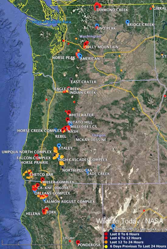
Large wildfires Washington Oregon northern California
Large wildfires currently active in Washington, Oregon, and Northern California. The red, yellow, and orange dots represent heat detected by a satellite in the 24 hour period ending at 10 a.m. MDT September 6.
These maps show the locations of large wildfires that are currently active in the Northwest United States. The red, yellow, and orange dots represent heat detected by a satellite in the 24 hour period ending at 10 a.m. MDT September 6.

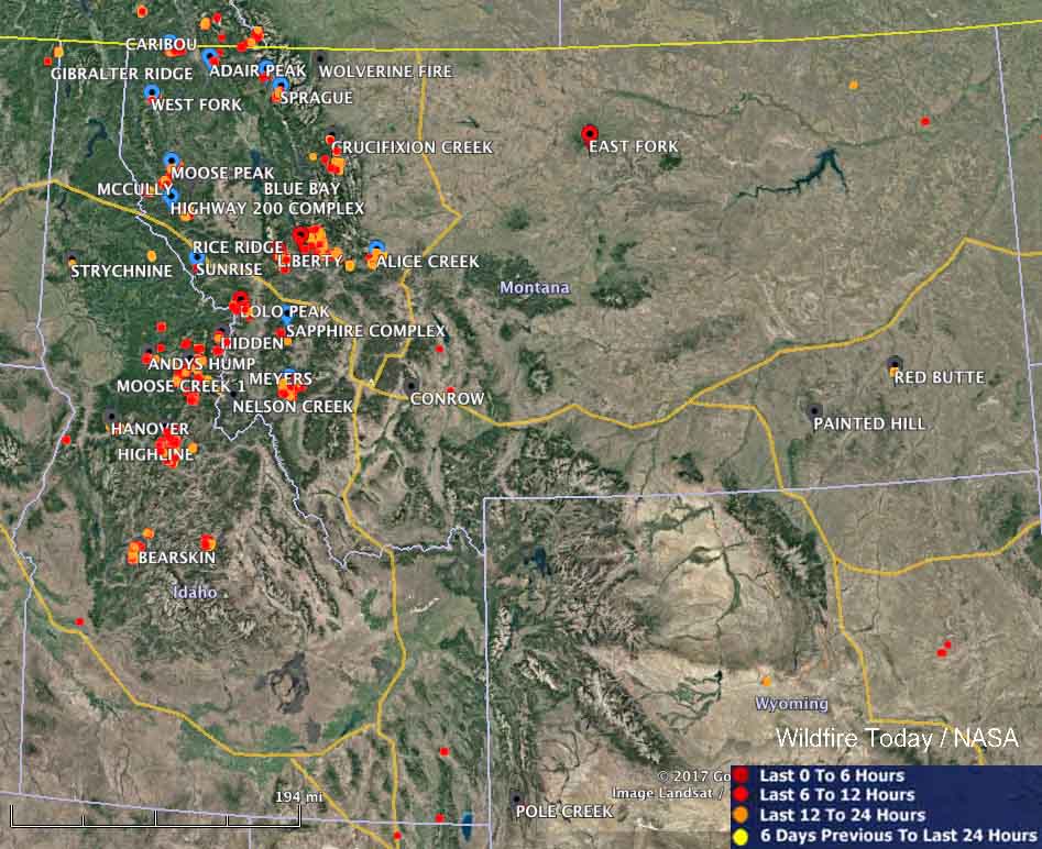
large wildfires map idaho montana
Large wildfires currently active in Idaho and Montana. The red, yellow, and orange dots represent heat detected by a satellite in the 24 hour period ending at 10 a.m. MDT September 6.

According to the National Interagency Coordination Center, today there are 50 large uncontained wildfires in the United States that are being aggressively suppressed. In addition, there are another 35 fires that are not being fully suppressed.

Very large numbers of firefighting resources are currently assigned across the United States, including 560 hand crews, 1,865 engines, and 222 helicopters, for a total of 27,256 personnel.

As of yesterday 7.9 million acres has burned this year nationally, which compares to the 10-year average of 5.4 million acres for this date.

The video below shows heat and smoke in Idaho and Montana detected by a satellite on September 3 and 4, 2017.

Dozens of wildfires very active in Montana and Idaho

Above: Wildfires in Montana and Idaho September 3, 2017. The map shows heat detected by a satellite during the 24-hour period ending at 10 p.m. MDT September 3, 2017.

(Originally published at 5:47 a.m. MDT September 4, 2017.)

Residents in eastern Montana and northern Idaho have been living with wildfires that are nearby for a couple of months and the situation continues today. Dozens of large fires are still eating up the acreage and creating heavy smoke and sometimes “unhealthy” air quality according to the monitoring services of the EPA and other organizations.

Satellite photo, wildfires in the Northwest U.S.

Click on the photo a couple of times to see a larger version.

Three Idaho firefighters injured when gas can falls off truck and ignites

Three firefighters with the Downey Fire Department in southeast Idaho (map) were injured when a gas can fell off their truck while fighting a vegetation fire. They were backing at the time and one of the tires on the five-ton, 6×6 truck ran over the can. The spilled gas ignited from an ember in the burned over area where they were at the time. The intense fire that developed burned all three firefighters, one of them over 40 percent of his body.

All three were transported to a hospital and two were transferred to the University of Utah Burn Center in Salt Lake City where a spokesperson said one was in critical condition and another was in serious condition. The third was treated and released. One of them also suffered a broken leg.

The truck was destroyed and the fire was knocked down after it spread to six acres.

Updated satellite photo of wildfires in Western Montana and Northern Idaho

Above: Satellite photo of smoke from fires in Western Montana and Northern Idaho, August 22, 2017. The red dots represent heat detected by a satellite.

(Originally published at 3:03 p.m. MDT August 22, 2017)

It has been many days since we were able to find a satellite photo free of clouds enough to see smoke from the wildfires in Western Montana and Northern Idaho, but today there were few clouds in the area. This photo from Tuesday afternoon shows less heat (the red dots) than what we were seeing one to two weeks ago.

Dozens of active wildfires in the Northwest U.S.

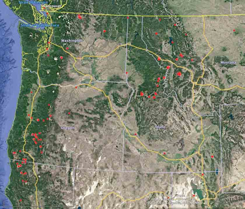
Above: Active wildfires in Washington, Oregon, Idaho, Western Montana, and Northern California at 4:18 a.m. MDT August 16, 2017.

(Originally published at 10:21 a.m. MDT August 16, 2017)

Dozens of wildfires are active in the Northwest one-quarter of the United States. Many of them have been burning for several weeks under a limited suppression strategy. The states of Washington and Oregon have a total of 32 large uncontained fires that have spread over 810,171 acres.

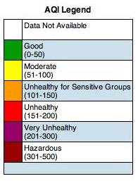
Air Quality Index LegendAt times the area around Missoula has been heavily affected by smoke. Here are some PM 2.5 readings from Wednesday morning:

  • Seeley Lake: 180
  • Missoula: 33
  • Lolo: 54
  • Superior: 180
  • French Town: 19
  • Clinton: 26
wildfires near Missoula, Montana
Satellite photo showing smoke from wildfires near Missoula, Montana, August 15, 2017.
wildfires northwest california
Satellite photo showing smoke from wildfires in northwest California, August 15, 2017.
wildfires northwest united states
Active wildfires (without added name tags) in Washington, Oregon, Idaho, Western Montana, and Northern California at 4:18 a.m. MDT August 16, 2017.