
During a 90-day detail to Nevada this year Micah Booze recorded video which he put together in the finished product below. It appears that he had an active three months. The video shows some pretty fancy editing. Thanks Micah.
News and opinion about wildland fire

During a 90-day detail to Nevada this year Micah Booze recorded video which he put together in the finished product below. It appears that he had an active three months. The video shows some pretty fancy editing. Thanks Micah.
In addition to the personnel injured in the helicopter crash, two rescuers became victims

A report has been released for a helicopter crash in a very remote area of Nevada that started a fire, injured two passengers, and resulted in rescuers being burned over. It happened August 18, 2018 about 10 miles north of Battle Mountain.
One of the passengers called 911 on a cell phone at 1357:
We just got into a helicopter crash…three occupants, all of us are alive and managed to get out…started a big fire, fire is burning all around us right now…one of the guys hit his head pretty hard…you’re gonna have to get a helicopter, it’s the only way to get in here.
Adding to the complexity was the fact that several different agencies and organizations had various responsibilities: Lander County Dispatch, Battle Mountain Volunteer Fire Department, local EMS services, a medical helicopter, Elko Interagency Dispatch Center, and Central Nevada Interagency Dispatch Center.
As might be expected the complex communication chain between the victims and the actual emergency responders created some difficulties, including a delay in extracting the three personnel.
The Facilitated Learning Analysis does not speculate what caused the crash of the helicopter that was transporting two biologists on a chukar survey, but it started a fire, which was named Sheep Creek. The biologists and the pilot self-extracted, one of them with what appeared to be a serious head injury, and they all hiked up a steep slope to a flat bench where they awaited a helicopter. About two hours after the 911 call the three were evacuated from the scene by a firefighting helicopter that was on scene, and possibly also a medical helicopter. The report is not clear about this.

Meanwhile a volunteer fire department Type 4 engine that had responded in a search and rescue mode toward the crash site found that the condition of the road they were traveling on deteriorated from a 2-track road to a 4×4 trail, and finally ended. At that point the fire was closing in on their location. The rookie firefighter and the Fire Chief got out, and leaving their wildland fire personal protective gear in the truck, began to spray water around the vehicle.
From the report:
Within seconds, the fire was all around Pumper- 2. Both individuals were caught outside of the vehicle while trying to spray water. Neither had on their personal protective equipment (PPE) when the burnover occurred. The Chief stated, “We were in a rescue mission, so we had no PPE on.”
During the burnover, the firefighter jumped off the back of Pumper-2, started to run around the vehicle and then took refuge under Pumper-2. “I was burning and screaming and hunkered down underneath behind the rear tires.” After the burnover, the Chief yelled for the firefighter, whom he could not see anywhere. He eventually located the firefighter under Pumper-2.
After sustaining significant burns, both the Chief and firefighter got back into the vehicle, with the Chief driving, continuing down drainage. The fire was behind them as they continued driving through the black towards the bottom of the drainage. Pumper-2 drove through the bottom of the drainage over the rough terrain until getting stuck. Both individuals got out of the vehicle and proceeded to hike up the steep ridge until they got on top of the ridge to establish communications.
At 1646, Lander County Dispatch received a 911 call from the firefighter, who said he and the Chief had been burned. “We need help.” Dispatch was asking questions to establish a location, but the cell phone was breaking up. The firefighter said, “We might need a helicopter because we are on the ridge…in the black…wearing a red shirt and just uphill right of the engine.”
Suppression resources were actively engaged on the wildland fire during the burnover of the Pumper-2. The Incident Commander of the wildland fire was unaware that Pumper-2 was on the fire until well after the burnover occurred. The dispatch centers did not know the location of Pumper-2.
At 1745 the injured firefighters were located and extracted by the air medical and suppression helicopters to awaiting ground medical resources at Battle Mountain Airport. At about 1900, fixed-wing aircraft flew the injured firefighters to the University of Utah Burn Center in Salt Lake City, Utah.
The FLA points out a number of organizational and human issues that are worthy of consideration. One topic that was not thoroughly addressed in the report was the dispatchers and firefighting personnel at times did not know the exact location of the crash site or the victims, and were not aware that the engine was responding or it’s location following the injuries to the two firefighters.
Even when, eventually, the location of emergency responders will be able to be tracked on an incident, biologists and volunteer firefighters will probably be some of the last personnel to employ this capability on a routine basis.
Above: screenshot from the video of the Martin Fire.
(UPDATED at 8:58 a.m. MDT July 9, 2018)
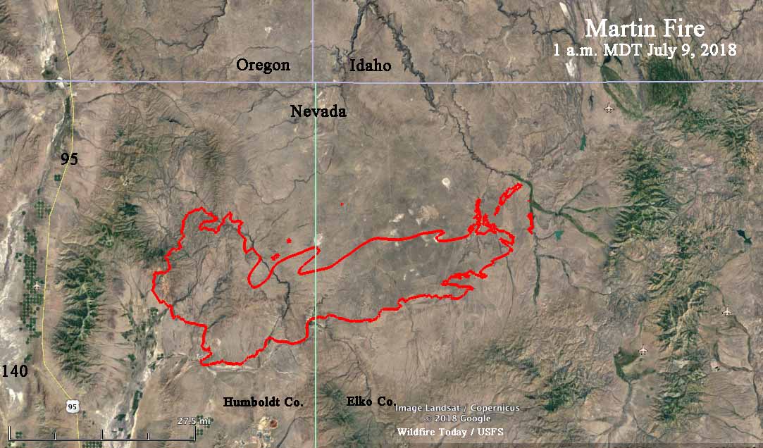
A new map of the rapidly growing Martin Fire in Northern Nevada reveals that it has exploded to 399,429 acres, according to the Incident Management Team. During an overnight fixed wing mapping flight some areas of light vegetation burned and then cooled, again making it difficult to fill in some of the holes where no heat was detected by the sensors.
The Martin Fire is 57 miles long, west to east.
(UPDATED at 6:30 a.m. MDT July 9, 2018)
The incident management team has posted an updated map of the Martin Fire on InciWeb.
(UPDATED at 6:50 p.m. MDT July 8, 2018)
According to satellite data acquired at 1:54 p.m. MDT Sunday the Martin Fire in Northern Nevada was extremely active at that time. It may have progressed over 20 miles during the previous 24 hours, reaching a total length of approximately 54 miles, west to east. At 1:54 p.m. it was 13 miles west of highway 11/226. Our very, very unofficial guestimate of the size at that time was about 380,000 acres. This is difficult to determine, because much of the vegetation that is burning is light, and can burn and then cool before the next infrared-sensing satellite overflight, occurring about every 12 hours. Our guess involved assuming some of the “unburned” holes had actually burned, but were undetectable by the satellite.
The map below shows approximately the same area as the one farther down dated July 7.

(UPDATED at 2:21 MDT July 8, 2018)
InciWeb is saying the Martin Fire has burned 164,000 acres but this map puts it at over 239,000 acres.
7/8 Sunday #MartinFire, north Nevada. This July 8 briefing map says 239,289 acres.. 3.0MB PDF file: https://t.co/FaVM8KUklu#GeoSpatialpic.twitter.com/fuXPlTFNb4
— Joseph Elfelt (@MappingSupport) July 8, 2018
(Originally published at 1:45 p.m MDT July 8, 2018)
The robotic cameras operated by the Nevada Seismological Lab have scored again, capturing some great time-lapse video of the Martin Fire in Northern Nevada as pyrocumulus clouds are being created. The video was shot from 6 to 7 p.m. on July 7, 2018.
The Martin Fire has burned 164,000 acres according to InciWeb, and on Saturday it spread from Humboldt County into Elko County.
 Fire perimeter produced by the Incident Management Team. Text notations by Wildfire Today.
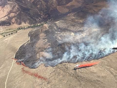
Rod Dines of the Payette National Forest took these photos from an aircraft while flying over a wildfire near Winnemucca, Nevada.

Above: Smoke from the Roosters Comb Fire was captured in a photo by the (non-operational) GOES-16 satellite at 7:30 p.m. MDT July 10, 2017.
(Originally published at 7:20 a.m. MDT July 11, 2017)
Four wildfires in northeast Nevada and southern Idaho are large enough that satellites are able, in some cases, to see the smoke and the blackened burned areas. These photos were taken late in the afternoon on Monday July 10.
The one putting up the most smoke Monday was the Roosters Comb Fire which as of Monday evening had burned approximately 25,000 acres in Nevada 17 miles northeast of Battle Mountain. It was reported at 9 p.m. Sunday July 9. The fire is spreading rapidly through grass, sagebrush, and pinyon-juniper.

Farther to the east in Nevada is the Tabor Flats Fire 27 miles northeast of Elko close to Interstate 80. The reported size of this fire is also 25,000 acres. The fire behavior in the tall grass is described as “extreme, running, flanking, wind driven runs”.
In Idaho the Loveridge Fire has burned over 38,000 acres 18 miles south of Mountain Home. It was shown as contained in the Tuesday morning national situation report. The heat detected by the satellite in that area (shown as red dots) could either be from the Loveridge Fire or a new fire in the same area.
The Antelope Fire at Shoshone, Idaho just south of Interstate 84 has covered 29,500 acres. It is exhibiting extreme fire behavior with wind-driven runs.
This satellite photo shows three wildfires near Reno, Nevada as seen by a satellite July 5, 2017 — the Earthstone, Truckee, and Winnemucca Ranch Fires. The burned areas appear very dark and the red dots represent heat.


