Structures burn in Oklahoma wildfire

A fire in the panhandle has burned over 29,000 ares

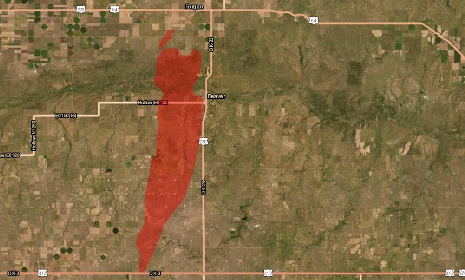
Map 412 Fire in Beaver County, Oklahoma
Map of the 412 Fire in Beaver County, Oklahoma. Data from 1:30 p.m. CDT March 8, 2020, by Oklahoma Forestry Services. The map shows a small fire northwest of the larger 412 Fire which is the Beaver Road Fire that occurred Sunday, March 1, 2020.

(UPDATED at 8:01 p.m. CDT March 8, 2020)

After more accurate mapping the Oklahoma Forestry Services reported Sunday afternoon that the Beaver Fire in Beaver County has burned 29,120 acres and is 50 percent contained. Crews continue to improve fireline and mopup hot spots.

On Saturday Cody Rehder of the Oklahoma Highway Patrol wrote on Twitter, “The town of Beaver is being evacuated at this time. The fire has reached the SW edge of town. Structures are on fire and the HS football field as burned.”
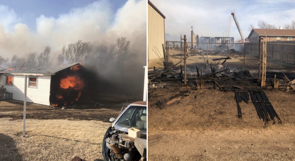
412 Fire in Beaver County, OK
Photos from the 412 Fire in Beaver County, OK. Photos by Cody Rehder of the OK Highway Patrol, March 7, 2020.

(UPDATED at 12:55 p.m.CST March 8, 2020)

The Beaver fire in the panhandle of Oklahoma is still estimated to be 13,000 acres, but that could change after more accurate mapping is complete. Saturday the Oklahoma Forestry Services responded to 30 new wildfires.

In a Sunday morning update the OFS said, “OFS are over the fire in an [Oklahoma Highway Patrol] aircraft mapping the fire and coordinating with ground resources. Rain chances do enter the southwestern part of the state this afternoon and gradually move east through the state, but going fires from yesterday will remain active.”
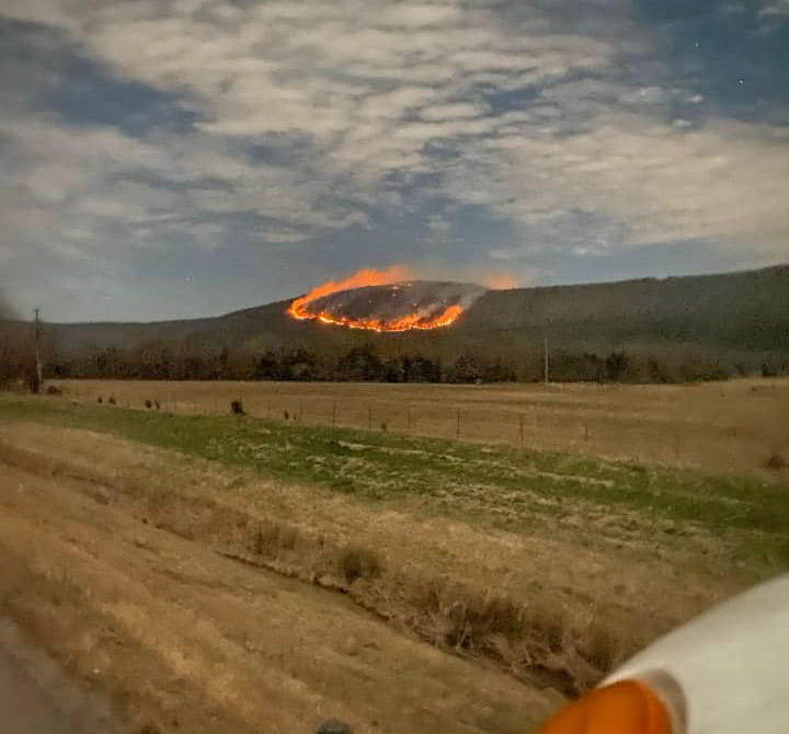
Crow Fire in Latimer County
A new fire Sunday morning, the Crow Fire, in Latimer Co. near Panola Mtn. OFS photo.

(Originally published at 9:37 p.m. CST March 7, 2020)

The 412 Fire in the Oklahoma panhandle has destroyed structures and burned approximately 13,000 acres, the Oklahoma Forestry Services (OFS) announced in an update at about 8 p.m. CST Saturday. At about 7:30 p.m. Saturday the OFS said fire had been at least temporarily stopped at the EW 100 road three miles north of Beaver.

The communities of Beaver and Forgan are under evacuation orders.  Firefighters from Oklahoma, Texas, and Kansas are battling the fire along with Air Tanker 95, a privately owned S-2 aircraft formerly operated by the California Department of Forestry and Fire Protection. The air tanker is under a call when needed arrangement in Kansas, operated by Ag Air Service out of Nikerson, Kansas. The aircraft can carry up to 800 gallons and still has the radial engines, unlike the S-2s operated by CAL FIRE today that have been converted to turbine engines.
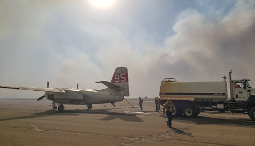
Air Tanker 95
Air Tanker 95. Photo by Kansas Forest Service.

There are no details available as to the number of structures that have been destroyed or the locations. Damage assessments are underway.
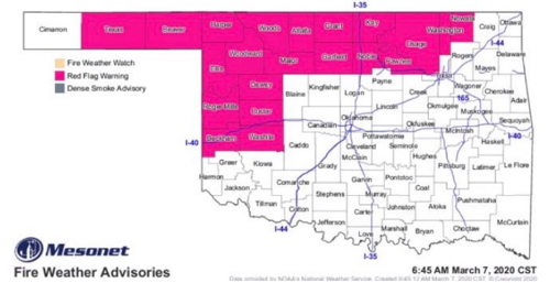
Red Flag Warnings Oklahoma
Red Flag Warnings in northwest Oklahoma, March 7, 2020.

The area was under a Red Flag Warning on Saturday. Strong winds pushed the fire approximately 14 miles across plains.

The 412 Fire occurs one day after the three-year anniversary of the huge Starbuck Fire that burned half a million acres across Oklahoma and Kansas. State and county officials estimated the fire caused at least $50 million in damages.

The 412 Fire near Beaver was one of 19 wildfires the OFS responded to across the state Saturday.
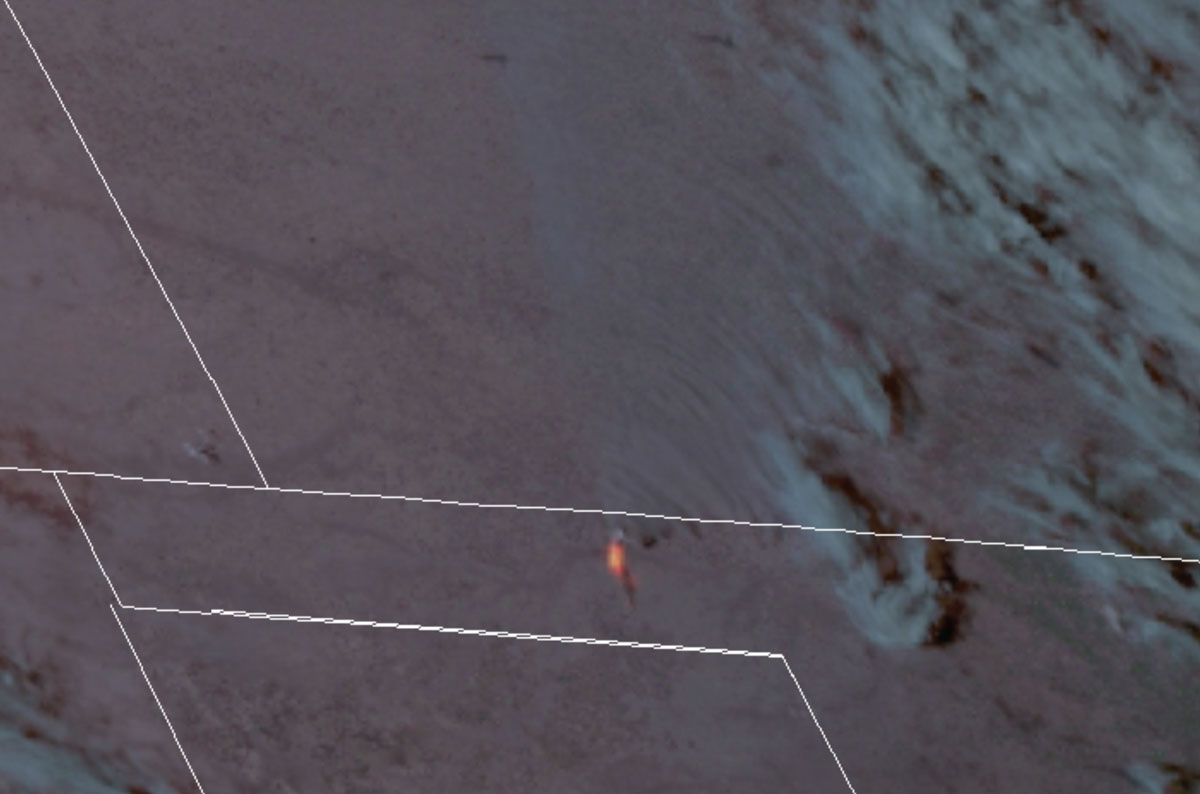
 

Oklahoma 412 fire wildfire Beaver
Satellite image showing heat detected on the 412 Fire in the Oklahoma panhandle at 5 p.m. DST March 7, 2020. GOES-17 NASA image.
Oklahoma 412 fire wildfire Beaver smoke
412 Fire, March 7, 2020. Photo by Oklahoma Forestry Services.

Thanks and a tip of the hat go out to Matt. Typos or errors, report them HERE.

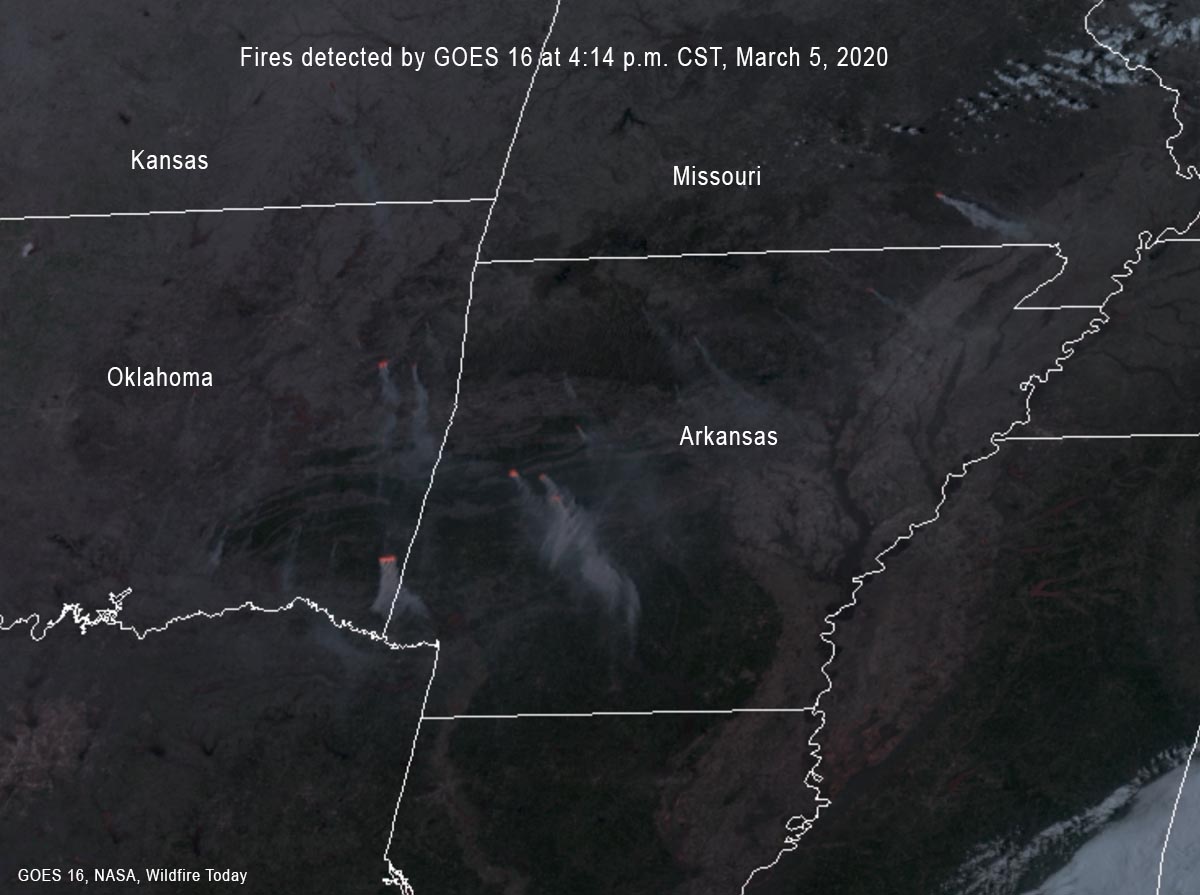
Satellite image of fires in Arkansas, March 5, 2020

Fires also detected in eastern OK and southeast MO

fires and smoke in Arkansas, Oklahoma, and Missouri
At 4:14 p.m. CST the GOES 16 satellite detected fires and smoke in Arkansas, Oklahoma, and Missouri. NASA data, processed by Wildfire Today.

At 4:14 p.m. CST on March 5 the GOES 16 satellite detected fires and smoke in Arkansas, eastern Oklahoma, and southeast Missouri. It is difficult to tell if they are wildfires, prescribed fires, or agricultural burning, but most of them appear to in forested areas.

The March 5 prediction for Red Flag Warnings designated areas of enhanced wildfire danger north and northwest of Arkansas.

wildfires Red Flag Warnings, March 5, 2020
Red Flag Warnings, March 5, 2020.

Oklahoma firefighter suffered severe burns after becoming entrapped

The firefighter was operating a UTV when it became disabled

Oklahoma Map EntrapmentOn September 12, 2019 an Oklahoma firefighter operating a UTV became entrapped during the initial attack of a wildfire in the southeast part of the state 24 miles northeast of Antlers.   The Oklahoma Forestry Services released the following preliminary information about the incident.


“On September 12, 2019 during initial attack efforts on the Jack Creek Fire, an Oklahoma Forestry Services firefighter from the Southeast Area / Antlers District was involved in an entrapment and subsequent burnover while scouting control line opportunities. The fire was burning in steep, rugged terrain dominated by dense pine forest with occasional hardwood glades. The firefighter was operating a UTV scouting logging roads for access and suppression opportunities when the UTV became disabled. The firefighters escape route was compromised when fire behavior increased due to the fire making an uphill run in the flashy understory fuels and crown fire in the canopy fuels. The firefighter did not deploy his fire shelter.

“The dispatch office requested an ambulance at the time of the incident while Oklahoma Forestry Services and local fire department personnel located the firefighter. The firefighter was transported to ground ambulance then transferred to air ambulance taking the firefighter to a burn center. The firefighter remains at the burn center and is being treated for second and third degree burns on >30% of his body with the most intense burns to his face and hands.

“An Incident Review Team has been assembled.”


Thanks and a tip of the hat go out to Matt. Typos or errors, report them HERE.
Over 2 million acres burned in Flint Hills in 28 days

map Flint Hills burning
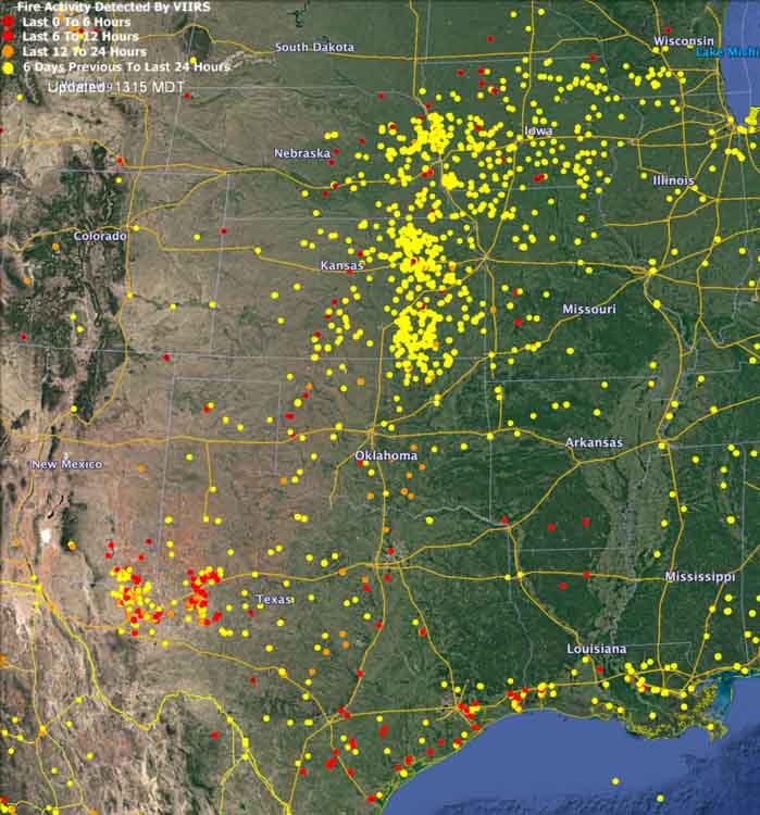
Map showing heat detected by satellites during the last seven days. Updated at 1 p.m. CDT April 19, 2019.

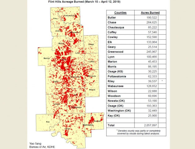
The Kansas Department of Health and Environment (KDHE) says the average annual acreage burned in the Flint Hills during the prescribed fire season was almost matched over the past month. Most of the burning is related to agriculture, improving pastures or preparing crop lands.

map flint hillsAlmost 2.1 million acres of grassland were treated with fire between March 15 and April 12. KDHE said roughly 2.5 million acres are burned annually.

The reporting time period includes 21 counties in Kansas and Oklahoma.

KDHE said burns from April 8-9 caused six air quality exceedances across parts of Kansas, Missouri and Oklahoma. There were no air quality exceedances due to burns last year.

acres burned county flint hills

Thanks and a tip of the hat go out to Matt. Typos or errors, report them HERE.
Burning sky lantern lands on Oklahoma man’s home

sky lantern
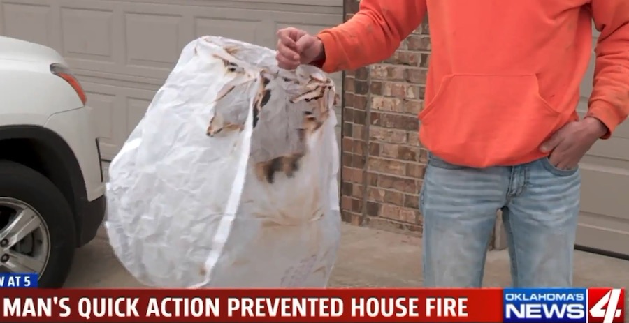
Screengrab from Fox61 video below.

As a man in Moore, Oklahoma pulled into his driveway he saw a burning sky lantern on the roof of his house. He was able to get it off the roof before the house caught fire, but was not pleased someone’s irresponsible act almost destroyed his home.

These dangerous devices use burning material to loft a small paper or plastic hot air balloon into the air. The perpetrator has no control over where it lands. Usually the fire goes out before it hits the ground, but not always. Sometimes the envelope catches fire while in flight. Numerous fires have been started by sky lanterns. Even if they don’t ignite a fire, they leave litter on the ground. Metal parts have been picked up by hay balers causing serious problems when fed to livestock. They are banned in most U.S. states and many countries.

Report released on fatality of Oklahoma grader operator

grader Jack Osben wildfire fatality
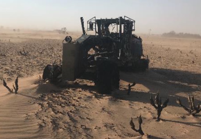
The grader that Jack Osben was operating. Photo taken two days after the burnover. From the FLA.

The Wildland fire Lessons Learned Center has released a Facilitated Learning Analysis on the fatality of Jack Osben, the grader operator who was burned over while working on the Shaw Fire in Western Oklahoma April 12, 2018. The tragedy occurred during extreme conditions — extended drought, 100 degrees, 5 percent relative humidity, 45 mph winds, and the fire was burning in thick grass that had not been grazed or hayed in seven to eight years.

The executive summary is below. The entire document can be downloaded (4 MB file).


*Except for Jack Osben, all names are pseudonyms

On April 12th, 2018, 61-year-old Jack Osben, a motor grader operator for Roger Mills County in Oklahoma and volunteer firefighter died as a result of thermal burns while providing initial attack to the Shaw Fire. The wildfire grew to approximately 3,500 acres in a mixture of grass and shrubs during a Red Flag Warning day. The employees of Roger Mills County were in a state of readiness due to a mixture of prolonged drought, extreme heat, and gusting winds that had created extremely dangerous wildfire conditions.

Shaw Fire grader fatality
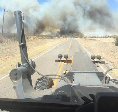
The Shaw Fire, as seen from a grader approaching the fire. From the FLA.

Jack was performing progressive line construction using a motor grader on the Shaw Fire. While he had been working as a grader operator for a few years, he had limited experience using the grader related to fire suppression activities. Between 1400-1430 hours Jack met up and began working with Alex, a fellow grader operator who had more than two decades of experience fighting fire.

Although they entered the field at different locations, they converged almost immediately. Alex instructed Jack to fall in line behind him to improve the initial grader line. After working together to establish line for about 4,000 feet, Alex lost sight of Jack’s grader in the smoke and flames, which had grown significantly and shifted directions quickly.

Due to the fire’s shift in direction, Alex was forced to abandon his grader. He began to walk toward a nearby road when he spotted Jack, who was also on foot emerging from the smoke. They spoke briefly when they met. Alex observed that Jack had visible burns to his arms and was possibly suffering from smoke inhalation. The reality was that Jack’s injuries were much worse than they appeared. He died as a result of thermal burns either during transit in the ambulance or right after arriving at the hospital.

This accident took place in Western Oklahoma where the tactical use of motor graders for wildland fire line construction is common. Additionally, there is different emphasis on values at risk, namely that firefighters in Western Oklahoma commonly protect grass for cattle grazing. Other regions may rank grass as a low value-at-risk but it is absolutely a consideration for how people in this region fight fire and manage land1.

This is the first Facilitated Learning Analysis (FLA) to emerge from the State of Oklahoma. In brief, the FLA process is meant to facilitate learning from unintended outcomes by interviewing people who were involved in the event, and sharing a collective story of their experiences. We also offer lessons learned from those involved and with their help, generate recommendations that may be useful for people within and outside of the region.

For many readers, this analysis will serve as an introduction to a different way of fighting fire with some of these methods appearing unconventional. But, in the words of one of the grader operators, “you make do with what you have.” Even if the methods and context are different, this statement ties together the ethos of wildland firefighters everywhere. It is also important to note that the men and women of Roger Mills County are exceptional at what they do and have an impressive record of doing it safely.