Wildfire potential February through May

On February 1 the Predictive Services section at the National Interagency Fire Center issued their Wildland Fire Potential Outlook for February through May, 2016. The data represents the cumulative forecasts of the ten Geographic Area Predictive Services Units and the National Predictive Services Unit.

If their forecasts are accurate it looks like mild fire potential until April and May when conditions could become more favorable to the spread of fires in the Midwest and south-central Alaska. Hawaii could become busy starting in February or March.

Here are the highlights from their outlook.

February

February wildfire potential

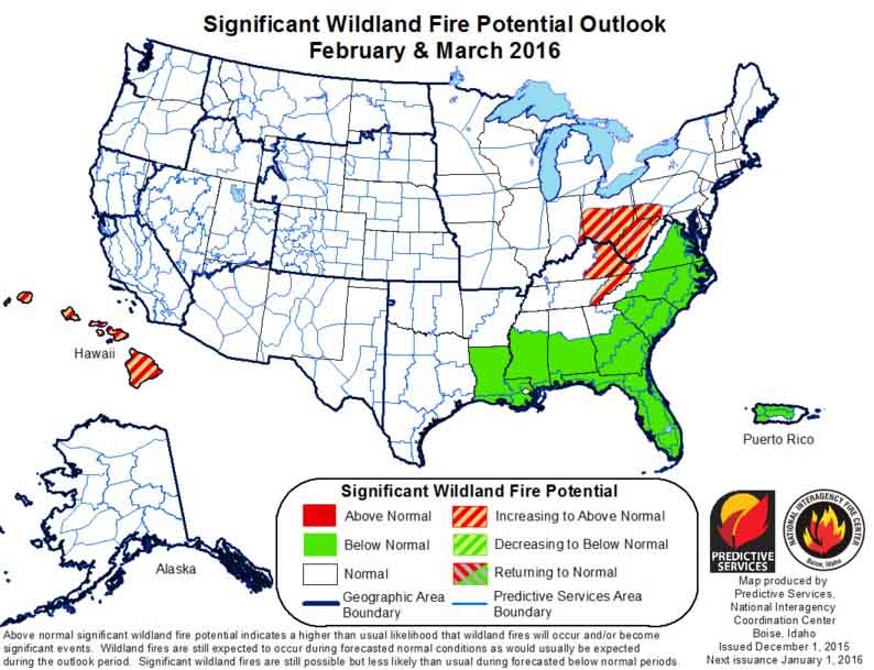
  • Below normal significant fire potential will persist across most of the Southeastern U.S., mid-Atlantic and Puerto Rico as El Nino storm systems continue to bring significant moisture to most of these areas.
  • Significant fire potential is normal across the remainder of the U.S., which indicates little significant fire potential.

March

March wildfire potential

  • Below normal significant fire potential will continue across most of the Southeastern U.S., mid-Atlantic and Puerto Rico as El Nino continues to bring significant moisture.
  • Above normal fire potential will also develop across the Hawaiian Islands thanks to long term drought.
  • Significant fire potential will remain normal across the remainder of the U.S., though potential for pre-greenup fire activity increases through early spring.

April and May

April May wildfire potential

  • Above normal significant fire potential will develop across the Great Lakes into the Ohio and Tennessee Valleys where less precipitation has occurred.
  • An area of above normal fire potential is also likely to develop across south central Alaska because warm temperatures and rain have limited snowpack.
  • Above normal fire potential will continue across the Hawaiian Islands as drought persists. Below normal significant fire potential will continue across most of the Southeastern U.S. and Puerto Rico.
  • Significant fire potential continues normal across the remainder of the U.S.

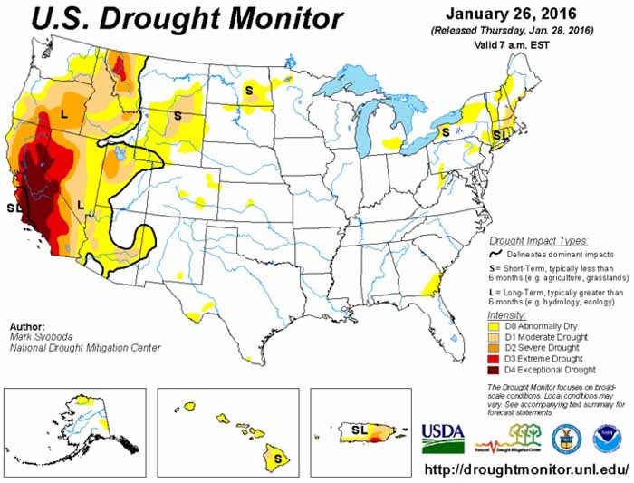
In addition to NIFC’s outlook, here’s bonus #1: the Drought Monitor released January 28, 2016.

Drought Monitor 1-28-2016

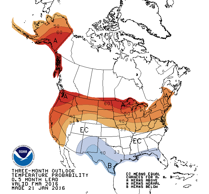
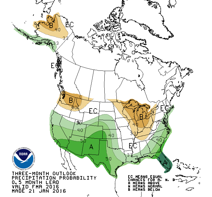
Bonuses #2 and #3, 90-day temperature and precipitation outlooks:


90 day temperature outlook

=================

90 day precipitation outlook

Wildfire potential through March, 2016

On December 1 the Predictive Services section at the National Interagency Fire Center issued their Wildland Fire Potential Outlook for December, 2015 through March, 2016. The data represents the cumulative forecasts of the ten Geographic Area Predictive Services Units and the National Predictive Services Unit.

If their forecasts are accurate, it looks like a continuation of pretty benign conditions across the United States this winter.

Here are the highlights from their outlook.

December
December wildfire 2015 Outlook

  • Significant fire potential is normal across the majority of the U.S.
  • Below normal significant wildland fire potential will persist across most of the Southeastern U.S. and Puerto Rico.

January
January 2016 wildfire Outlook

  • Significant fire potential is normal across the majority of the U.S.
  • Below normal significant wildland fire potential will persist across most of the southeastern U.S. and Puerto Rico.

February-March
February-March 2016 wildfire Outlook

  • An area of above normal significant fire potential will develop across the central interior portion of the eastern U.S. Above normal potential will also affect the Hawaiian Islands.
  • Below normal significant wildland fire potential will persist across most of the Southeastern U.S. and Puerto Rico.
  • Significant fire potential is normal across the majority of the U.S.

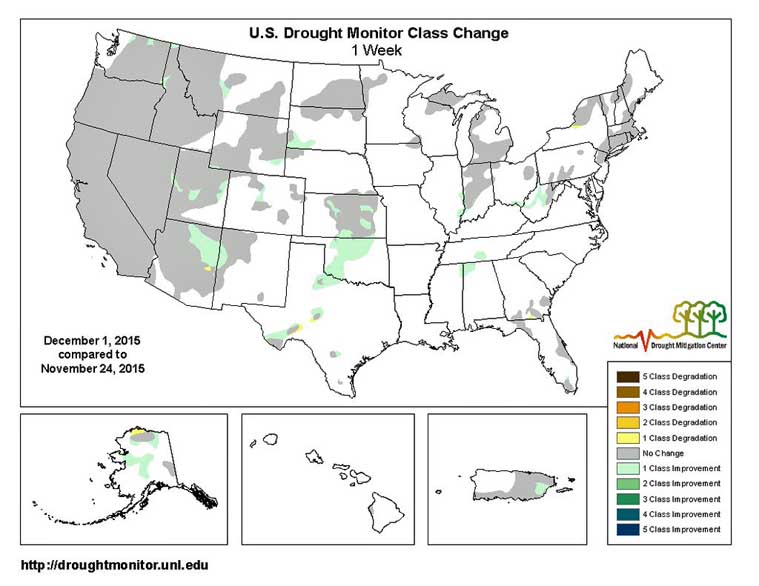
And as a bonus — the Drought Monitor:

Drought Monitor December 1, 2015

Drought Monitor Change

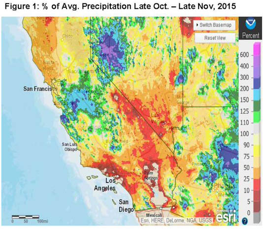
Bonus #2, Percent of Normal Precipitation:

Precip percent of normal California

Wildfire potential through February, 2016

The Predictive Services section at the National Interagency Fire Center issued their Wildland Fire Potential Outlook through February, 2016. The data represents the cumulative forecasts of the ten Geographic Area Predictive Services Units and the National Predictive Services Unit.

If their forecasts are accurate, it looks like pretty benign conditions across the United States this winter except for southern California in November.

Here are the highlights from their outlook.

November

wildfire potential

  • Significant fire potential has reduced to normal fall conditions across most of the U.S.
  • Above normal significant fire potential will continue across southern California due to continued drought. All areas of above normal potential should return to normal by the end of November.
  • A Large portion of the southern U.S. will see below normal significant fire potential. Typical fire activity should be less than usual across a majority of the eastern U.S. for the fall.
  • Puerto Rico and the Hawaiian Islands will see below normal conditions as well.
  • Elsewhere normal fall conditions will prevail.

December

wildfire potential

  • No areas of above normal significant fire potential will remain in the U.S.
  • Portions of the Southeastern U.S., Hawaiian Islands and Puerto Rico will continue to see below normal potential.
  • Normal conditions are expected elsewhere.

January-February, 2016

wildfire potential

  • Portions of the Southeastern U.S, and Puerto Rico will continue to see below normal potential.
  • Normal conditions are expected elsewhere.

Wildfire potential through January, 2016

The Predictive Services section at the National Interagency Fire Center issued their Wildland Fire Potential Outlook through January, 2016. The data represents the cumulative forecasts of the ten Geographic Area Predictive Services Units and the National Predictive Services Unit.

If their forecasts are accurate, the only areas with above normal wildfire potential during that period will be in California and Minnesota.

Here are the highlights from their outlook.

October

wildfire potential October 2015

  • Significant fire potential has reduced to normal fall conditions across most of the areas where fire activity concerns were prevalent through September.
  • Above normal significant fire potential will continue across central and southern California due to continued drought and dry fuels. Central portions of the state will return to normal by the end of the month.
  • Northwestern Minnesota will see short term elevated significant fire potential through October.
  • Portions of the Mississippi and Ohio Valleys, Puerto Rico and the Hawaiian Islands will see below normal conditions.
  • Elsewhere normal fall conditions will prevail.

November

wildfire potential November , 2015

  • The remainder of the above normal potential will return to normal by the end of November in California.
  • Portions of the Southeastern U.S., Hawaiian Islands and Puerto Rico will continue to see below normal potential.
  • Normal conditions are expected elsewhere.

December, 2015 and January, 2016

wildfire potential December January

  • Portions of the Southeastern U.S., Hawaiian Islands and Puerto Rico will continue to see below normal potential.
  • Normal conditions are expected elsewhere.

(end of Fire Potential report)

****

Below is the Drought Monitor analysis

Drought Monitor

Precipitation, departure from normal

The map below shows the how the amount of precipitation recorded during September, 2015 departed from normal for that period.

Precip, departure from normal

Outlook for wildfire potential, September through December, 2015

The Predictive Services section at the National Interagency Fire Center has issued their Wildland Fire Potential Outlook for September through December, 2015. The data represents the cumulative forecasts of the ten Geographic Area Predictive Services Units and the National Predictive Services Unit.

If their forecasts are accurate, above normal wildfire potential will continue in the Northwest and southern California through September, but beginning in October it will exist only in southern California, and temporarily in a portion of central Texas.

Here are the highlights from their outlook.

September

September wildfire outlook

  • Significant fire potential will remain above normal across much of Washington, northeastern Oregon, northern Idaho and northwestern Montana.
  • Above normal significant fire potential will continue across the mountains of southern California.
  • Below normal fire potential will occur over the Mid-Mississippi and Ohio Valleys and most of Florida.

October

Ocdtober wildfire outlook

  • The southern California coastal region will remain in above normal fire potential while the central coast and the Sierras return to normal fire potential.
  • Below normal fire potential will spread across the Ohio, Tennessee and Mid-Mississippi Valleys.

November through December

November wildfire outlook

  • Southern California will return to normal in November.
  • Below normal fire potential will spread over the coastal states from Texas to North Carolina.

Outlook for wildfire potential, August through November, 2015

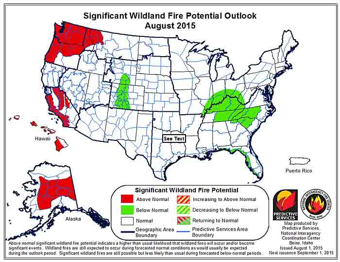
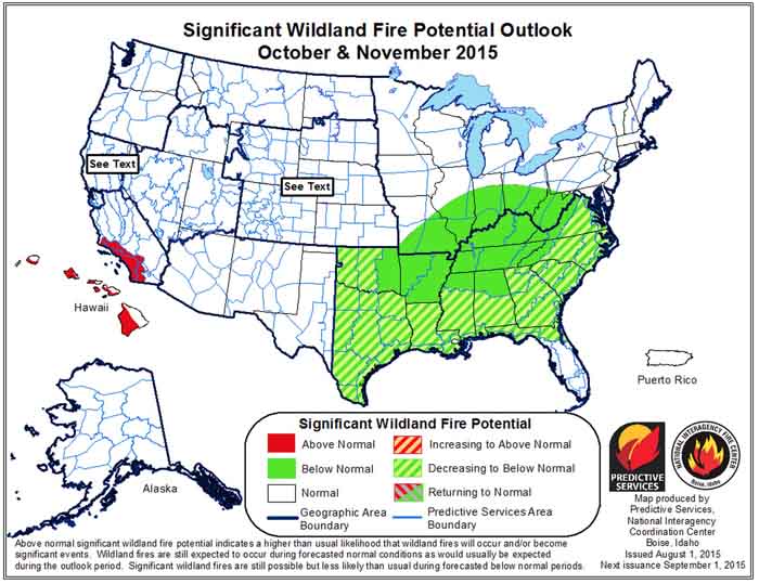
The Predictive Services section at the National Interagency Fire Center has issued their Wildland Fire Potential Outlook for August through November, 2015. The data represents the cumulative forecasts of the ten Geographic Area Predictive Services Units and the National Predictive Services Unit.

If their forecasts are accurate, portions of Idaho, Washington, Oregon, California, Alaska, and Montana will have above normal wildfire activity through September.

It is interesting that northern California, where many fires are growing at very, very rapid rates, has “normal” wildfire potential according to the analysis for August, perhaps because of this statement in the document about northern California:

The strengthening El Niño pattern will cause occasional monsoon surges, mainly in August.

Here are the highlights from their outlook.

****

August

wildfire potential August

  • Drier than normal fuels and little forecasted relief have led to above normal significant fire potential for most of the Northwest and western
    portions of the Northern Rockies.
  • Long term drought will keep significant fire potential above normal in Southern California.
  • Alaska will see continued periodic acreage growth from established fires which will lead to overall above normal significant fire potential.
  • Elsewhere mostly normal activity should be expected; which includes frequent significantfires and plentiful initial attack for August.

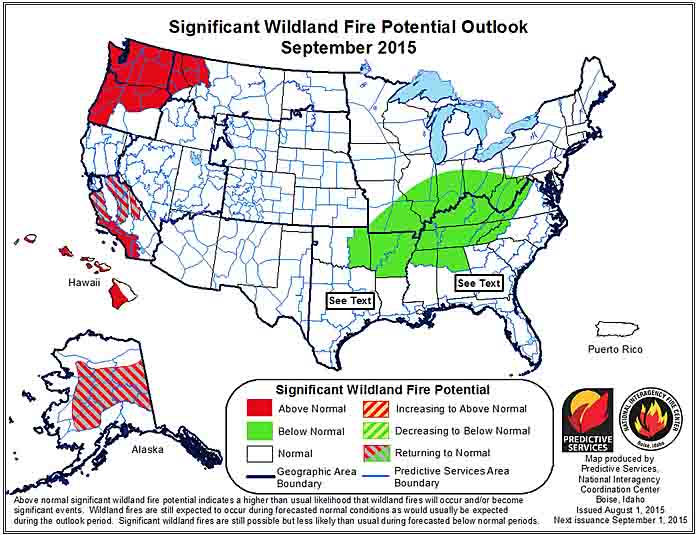
September

wildfire potential September

  • Central California and Alaska will see significant fire potential return to normal; however dry conditions are expected to persist in the Northwest, western Northern Rockies and far Southern California. 
  • Elsewhere primarily normal activity should be prevalent. For September, this means a rapid decline in both numbers of fires and acres burned for most Areas.

October-November

wildfire potential October November

  • Far Southern California will remain above normal for October and November; while most of the rest of the U.S. will be normal in many areas indicating little or no fire activity.
  • Below normal significant fire potential across most of the eastern U.S. for this period thanks to frequent moisture inputs represents a reduced fall and winter fire season for U.S. overall.

****

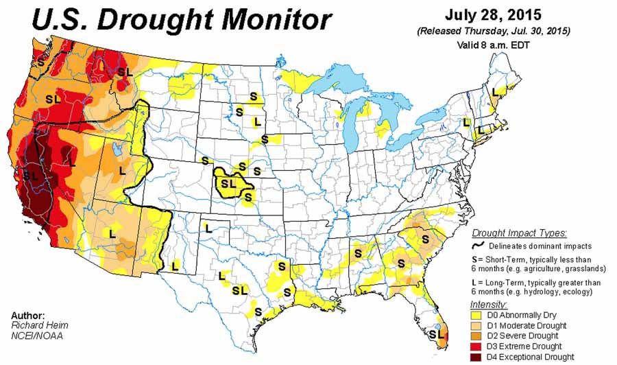
As a bonus, here is the Drought Monitor from July 28, 2015:

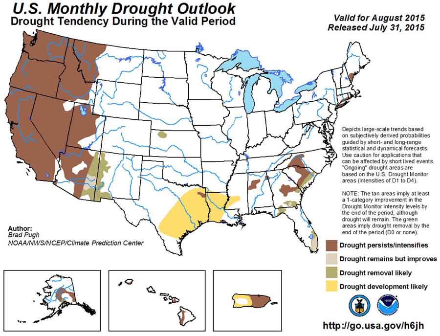
Drought Monitor July 28, 2015And, the U.S. Drought Outlook for August:

US Drought Outlook, August, 2015